
Myanmar–Thailand border

The Myanmar–Thailand border is the international border between the territory of Myanmar (formerly Burma) and Thailand. The border is 2,416 km (1,501 mi) in length and runs from the tripoint with Laos in the north to the Andaman Sea coast in the south.[1]
Description
The border starts in the north at the tripoint with Laos at the confluence of the
History
The border regions have historically been contested between the various Thai and Burmese states.
In 1868 Britain and Siam signed a treaty delimiting the Burma-Thai border from the Salween south to the Andaman Sea.[2] Following some confusion as to the border's location, on the ground demarcation of the border commenced from 1889 to 1892.[2] In 1892 the northern section of the border delimited and then demarcated on the ground from 1893 to 1894, with a final boundary treaty with maps signed on 17 October 1894.[2] The northern terminus of the border was fixed in 1896 when the British and French agreed that the Mekong would serve as the Burma-Laos border.[2] Some minor boundary adjustments occurred in 1929 and 1934.[2] In 1941, following Japan's invasion of Burma, parts of Burma were ceded to Siam as the Saharat Thai Doem territory, however these areas were returned to Burma in 1946 following Japan's defeat and since then the border has remained in place.[2][5][6] In 1937 Burma was separated from India and became a separate colony, gaining full independence in 1948, at which point the border became an international frontier between two sovereign states.[2]
At present there is an outstanding dispute over the ownership of some small islands in the Andaman Sea.[7]
From 2010 to 2012 there were clashes along the border between the Myanmar army and the Karen National Liberation Army.[8][9]
In 2021, the Myanmar military clashed with civilians in the border areas. Many of them fled and ended up in Thailand. [10]
In 2023 there were more clashes and the governments of both countries have decided to form a humanitarian task force. [11][12]
Border crossings
As of 2019[update], there were 6 permanent border crossings, 1 temporary border crossing, 13 checkpoints for border trade and 1 special checkpoint for border trade.[13]
Permanent border crossings
| No | Myanmar | Thailand | Notes | ||
|---|---|---|---|---|---|
| Border post | Road | Border post | Opening hours | ||
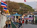
| 1 | Tachileik, Shan State | 1 | Mae Sai 1, Mae Sai District, Chiang Rai
|
0630 - 2100 | The border crossing is via the First Bridge over the Sai River. |
| 2 | 1041 | Mae Sai 2, Mae Sai District, Chiang Rai
|
0630 -1830 | The border crossing is via the Second Bridge over the Sai River. | |
| 3 | Myawaddy, Kayin State | 12 | Mae Sot 1, Mae Sot District, Tak
|
0530 - 2030 | The border crossing is via the First Thai-Myanmar Friendship Bridge over the Moei River. |
| 4 | 130 | Mae Sot 2, Mae Sot District, Tak
|
0630 - 1830 | The border crossing is via the Second Thai-Myanmar Friendship Bridge over the Moei River. | |
| 5 | Htee Kee, Dawei, Tanintharyi Region | 3229 | Ban Mueang Kanchanaburi District, Kanchanaburi
|
0600 - 2000 | |
| 6 | Kawthaung, Tanintharyi Region | - | Bang Rin Fisheries Pier, Mueang Ranong District, Ranong | 0630 - 0000 | Ferry Border Crossing. Consists of checkpoints located adjacent to 4 separate piers on the Thai side. |
| Pak Nam Ranong, Mueang Ranong District, Ranong | |||||
| Ranong Customs Pier, Mueang Ranong District, Ranong | |||||
| Andaman Club Pier, Mueang Ranong District, Ranong | |||||

Temporary border crossings
These border crossings are open for foreigners for travel purposes only.
| No | Myanmar | Thailand | Notes | ||
|---|---|---|---|---|---|
| Border post | Road | Border post | Opening hours | ||
| 1 | Payathonzu, Kayin State | 323 | Dan Phra Chedi Sam Ong (Three Pagodas Pass), Sangkhla Buri District, Kanchanaburi | 0830 - 1800 | |
Checkpoints for border trade
These border crossings are open for cross-border local trade only. There are 13 checkpoints for border trade officially recognized by the Ministry of Interior, located in Chiang Rai, Chiang Mai, Mae Hong Son and Ranong provinces. Entering the opposite country beyond these checkpoints and their associated markets is illegal.
Special checkpoint for border trade
One special checkpoint for border trade is planned as a future permanent crossing. Entering the opposite country beyond these checkpoints and their associated markets is currently[may be outdated] illegal.
| No | Myanmar | Thailand | Notes | ||
|---|---|---|---|---|---|
| Border post | Road | Border post | Opening hours | ||
| 1 | Mawdaung, Tanintharyi Region | 1039 | Mueang Prachuap Khiri Khan District, Prachuap Khiri Khan
|
0630 - 1800 | |
Gallery
-
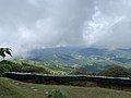 A scenic viewpoint of the border along theMae Sai District
 -
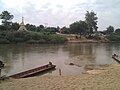
 Pier at Kawthaung
 -
 The border along the Moei river, with Myanmar on the opposite bank
 -
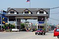
 Border gate at Mae Sai
 -
 The border bridge at Tachilek
 -
 Mae Sot border crossing
 -
 Border control gate at Dan Sing Khon


See also
References
- ^ "Burma". CIA World Factbook. Retrieved 19 September 2020.
- ^ a b c d e f g h i j "International Boundary Study No. 63 – Burma – Thailand Boundary" (PDF). US Department of State. 1 February 1966. Retrieved 19 September 2020.
- ISBN 978-9749480502.
- ISBN 978-9748496252.
- ^ Donald M. Seekins, Historical Dictionary of Burma (Myanmar), p. 251
- ^ "A Forgotten Invasion: Thailand in Shan State, 1941–45"
- ^ Sophal, Sek (13 January 2020). "New subs sign of troubles to come?" (Opinion). Bangkok Post. Retrieved 13 January 2020.
- ^ "Thousands flee Myanmar clashes". Al Jazeera. 8 November 2010. Retrieved 9 November 2010.
- ^ "Civil war threatens following Burma's election". ABC News. November 9, 2010. Retrieved 9 November 2010.
- ^ "Myanmar army air raids send hundreds fleeing into Thailand".
- ^ "Thailand trying to rescue 162 nationals as tens of thousands flee Myanmar fighting". Retrieved 2024-02-08.
- ^ "Thailand, Myanmar to form aid task force as border unrest intensifies". Retrieved 2024-02-08.
- ^ "ข้อมูลช่องทางผ่านแดนและความตกลงเรื่องการสัญจรข้ามแดน". Foreign Affairs Division Office, Office of the Permanent Secretary, Ministry of the Interior.
Borders of Myanmar | |
|---|---|