
Nagaoka, Niigata
You can help expand this article with text translated from the corresponding article in Japanese. (February 2022) Click [show] for important translation instructions.
|
Nagaoka
長岡市 | |||||||||||||||||||
|---|---|---|---|---|---|---|---|---|---|---|---|---|---|---|---|---|---|---|---|
| |||||||||||||||||||
|
UTC+9 (Japan Standard Time) | |||||||||||||||||||
| Phone number | 0258-35-1122 | ||||||||||||||||||
| Address | 1-4-10 Otedori, Nagaoka-shi, Niigata-ken 940-8501 | ||||||||||||||||||
| Climate | Cfa | ||||||||||||||||||
| Website | Official website | ||||||||||||||||||
| Symbols | |||||||||||||||||||
| Fish | Nishiki koi | ||||||||||||||||||
| Flower | Azalea | ||||||||||||||||||
| Tree | Zelkova serrata | ||||||||||||||||||


Nagaoka (長岡市, Nagaoka-shi) is a
Geography

Nagaoka is in the center of Niigata prefecture and the surrounding
Surrounding municipalities
- Niigata Prefecture
- Tsubame
- Yahiko
- Nishikan-ku, Niigata
- Izumozaki
- Kashiwazaki
- Kariwa
- Tōkamachi
- Ojiya
- Uonuma
- Sanjō
- Mitsuke
Climate
Nagaoka has a humid climate (Köppen Cfa) characterized by warm, wet summers and cold winters with heavy snowfall. The average annual temperature in Nagaoka is 13.3 °C (55.9 °F). The average annual rainfall is 2,349.3 mm (92.49 in) with September as the wettest month. The temperatures are highest on average in August, at around 26.2 °C (79.2 °F), and lowest in January, at around 1.6 °C (34.9 °F).[3]
| Climate data for Nagaoka (1991−2020 normals, extremes 1976−present) | |||||||||||||
|---|---|---|---|---|---|---|---|---|---|---|---|---|---|
| Month | Jan | Feb | Mar | Apr | May | Jun | Jul | Aug | Sep | Oct | Nov | Dec | Year |
| Record high °C (°F) | 15.0 (59.0) |
18.9 (66.0) |
23.3 (73.9) |
30.4 (86.7) |
32.8 (91.0) |
37.0 (98.6) |
39.4 (102.9) |
39.4 (102.9) |
38.3 (100.9) |
35.3 (95.5) |
26.5 (79.7) |
19.9 (67.8) |
39.4 (102.9) |
| Mean daily maximum °C (°F) | 4.5 (40.1) |
5.2 (41.4) |
9.4 (48.9) |
16.5 (61.7) |
22.3 (72.1) |
25.7 (78.3) |
29.1 (84.4) |
30.9 (87.6) |
26.7 (80.1) |
20.6 (69.1) |
14.0 (57.2) |
7.6 (45.7) |
17.7 (63.9) |
| Daily mean °C (°F) | 1.6 (34.9) |
1.8 (35.2) |
4.9 (40.8) |
11.0 (51.8) |
16.9 (62.4) |
21.0 (69.8) |
24.8 (76.6) |
26.2 (79.2) |
22.0 (71.6) |
15.9 (60.6) |
9.6 (49.3) |
4.2 (39.6) |
13.3 (56.0) |
| Mean daily minimum °C (°F) | −0.7 (30.7) |
−1.1 (30.0) |
1.1 (34.0) |
6.0 (42.8) |
12.1 (53.8) |
17.1 (62.8) |
21.4 (70.5) |
22.5 (72.5) |
18.3 (64.9) |
12.0 (53.6) |
6.0 (42.8) |
1.5 (34.7) |
9.7 (49.4) |
| Record low °C (°F) | −9.7 (14.5) |
−11.8 (10.8) |
−6.3 (20.7) |
−2.8 (27.0) |
2.9 (37.2) |
9.0 (48.2) |
13.0 (55.4) |
14.1 (57.4) |
8.1 (46.6) |
2.5 (36.5) |
−1.9 (28.6) |
−8.4 (16.9) |
−11.8 (10.8) |
| Average precipitation mm (inches) | 294.4 (11.59) |
165.5 (6.52) |
140.8 (5.54) |
103.7 (4.08) |
97.8 (3.85) |
136.9 (5.39) |
235.0 (9.25) |
163.9 (6.45) |
165.6 (6.52) |
184.6 (7.27) |
289.0 (11.38) |
372.2 (14.65) |
2,349.3 (92.49) |
| Average snowfall cm (inches) | 197 (78) |
155 (61) |
52 (20) |
1 (0.4) |
0 (0) |
0 (0) |
0 (0) |
0 (0) |
0 (0) |
0 (0) |
1 (0.4) |
76 (30) |
477 (188) |
| Average precipitation days (≥ 1.0 mm) | 25.8 | 20.5 | 18.7 | 13.4 | 10.6 | 11.5 | 13.8 | 11.1 | 13.6 | 15.1 | 19.9 | 24.7 | 198.7 |
| Average snowy days (≥ 3 cm) | 17.1 | 15.2 | 5.9 | 0.1 | 0 | 0 | 0 | 0 | 0 | 0 | 0.2 | 7.1 | 45.6 |
| Mean monthly sunshine hours | 37.3 | 60.6 | 117.9 | 170.8 | 201.3 | 155.4 | 143.9 | 193.5 | 141.0 | 132.4 | 88.3 | 49.3 | 1,493.9 |
| Source: Japan Meteorological Agency[4][3] | |||||||||||||
| Climate data for Teradomari, Nagaoka (2001−2020 normals, extremes 2001−present) | |||||||||||||
|---|---|---|---|---|---|---|---|---|---|---|---|---|---|
| Month | Jan | Feb | Mar | Apr | May | Jun | Jul | Aug | Sep | Oct | Nov | Dec | Year |
| Record high °C (°F) | 14.6 (58.3) |
21.7 (71.1) |
23.3 (73.9) |
26.8 (80.2) |
31.2 (88.2) |
33.0 (91.4) |
39.4 (102.9) |
40.6 (105.1) |
38.0 (100.4) |
32.1 (89.8) |
24.2 (75.6) |
18.8 (65.8) |
40.6 (105.1) |
| Mean daily maximum °C (°F) | 5.7 (42.3) |
6.7 (44.1) |
10.7 (51.3) |
15.9 (60.6) |
21.1 (70.0) |
25.0 (77.0) |
28.3 (82.9) |
30.6 (87.1) |
26.7 (80.1) |
20.8 (69.4) |
14.6 (58.3) |
8.6 (47.5) |
17.9 (64.2) |
| Daily mean °C (°F) | 2.6 (36.7) |
2.9 (37.2) |
5.9 (42.6) |
10.7 (51.3) |
16.0 (60.8) |
20.3 (68.5) |
24.1 (75.4) |
25.9 (78.6) |
21.9 (71.4) |
16.0 (60.8) |
10.2 (50.4) |
5.1 (41.2) |
13.5 (56.2) |
| Mean daily minimum °C (°F) | −0.1 (31.8) |
−0.3 (31.5) |
1.8 (35.2) |
6.3 (43.3) |
11.9 (53.4) |
16.7 (62.1) |
21.1 (70.0) |
22.5 (72.5) |
18.4 (65.1) |
12.2 (54.0) |
6.5 (43.7) |
1.9 (35.4) |
9.9 (49.8) |
| Record low °C (°F) | −6.6 (20.1) |
−6.4 (20.5) |
−5.3 (22.5) |
−1.3 (29.7) |
4.6 (40.3) |
10.0 (50.0) |
14.4 (57.9) |
15.6 (60.1) |
7.9 (46.2) |
3.9 (39.0) |
−1.6 (29.1) |
−3.3 (26.1) |
−6.6 (20.1) |
| Average precipitation mm (inches) | 181.6 (7.15) |
111.3 (4.38) |
114.8 (4.52) |
103.4 (4.07) |
91.3 (3.59) |
127.9 (5.04) |
273.7 (10.78) |
150.4 (5.92) |
160.5 (6.32) |
154.3 (6.07) |
219.0 (8.62) |
247.4 (9.74) |
1,962.9 (77.28) |
| Average precipitation days (≥ 1.0 mm) | 22.8 | 17.8 | 16.3 | 12.4 | 10.3 | 9.5 | 14.4 | 10.7 | 12.6 | 13.7 | 19.2 | 23.8 | 183.5 |
| Mean monthly sunshine hours | 46.1 | 76.8 | 140.9 | 187.3 | 212.3 | 194.7 | 160.1 | 216.9 | 168.0 | 141.4 | 86.5 | 49.5 | 1,675.3 |
| Source: Japan Meteorological Agency[5][6] | |||||||||||||
Demographics
Per Japanese census data,[7] the population of Nagaoka peaked at around 1995 and has declined steadily since.
| Year | Pop. | ±% |
|---|---|---|
| 1960 | 284,026 | — |
| 1970 | 279,395 | −1.6% |
| 1980 | 289,234 | +3.5% |
| 1990 | 290,923 | +0.6% |
| 2000 | 292,887 | +0.7% |
| 2010 | 282,674 | −3.5% |
| 2020 | 266,539 | −5.7% |
History


The area of present-day Nagaoka was part of ancient
With the Meiji period creation of the modern municipalities system on April 1, 1889, the towns of Nagaoka and Nagaoka-honmachi were established. The two towns were merged on November 1, 1901 with the towns of Senju, Kusouzu, Ara, and village of Ouchi to form the modern town of Nagaoka, which was then raised to city status on April 1, 1906.
Municipal timeline

- April 1, 1906: The city of Nagaoka is established.
- August 1, 1945: Nagaoka is reduced to rubble by 125 Bombing of Nagaoka in World War II. 1,470 lives are lost.
- January 1963: A record-breaking heavy snowfall hits Nagaoka.
- November 15, 1982: Joetsu Shinkansenservice arrives at Nagaoka Station.
- July 12–13, 2004: A heavy downpour causes extensive flooding in Nagaoka.
- October 23, 2004: The Chūetsu earthquake strikes, causing extensive damage in Nagaoka and surrounding areas.
- February 2005: Nagaoka experiences the heaviest snowfall in 19 years.
- April 1, 2005: The town of Oguni (from Kariwa District), the village of Yamakoshi (from Koshi District), the town of Nakanoshima (from Minamikanbara District), and the towns of Koshiji and Mishima (both from Santō District), were absorbed into Nagaoka.[8][9]
Prior to the merger, the size of Nagaoka was 262.45 km² and the population was 192,292.
- January 1, 2006: The city of Tochio, the towns of Teradomari and Yoita, and the village of Washima (all from Santō District) were absorbed into Nagaoka.[10][11]
- April 1, 2007: Nagaoka is designated a special city with increase local autonomy
- March 31, 2010: The town of Kawaguchi (from Kitauonuma District) was absorbed into Nagaoka.[12]
Government

Nagaoka has a
Economy
Industry
The manufacturing industry prospered in Nagaoka following World War II, due in part to favorable location and good transportation infrastructure. Current industrial production includes precision instruments and machine tools.
- Nippon Seiki, a manufacturer of automotive instruments, is headquartered in Nagaoka.
- TDK-Lambda, a manufacturer of switched-mode power supplies, has a plant in Nagaoka.
- Schlumberger, an oilfield services company has a location in Nagaoka.
Education
Universities and colleges
- Nagaoka University of Technology
- National Institute of Technology, Nagaoka campus
- Nagaoka University
- Nagaoka Institute of Design
Primary and secondary education
The city of Nagaoka operates 61 public elementary schools and 27 public middle schools. There is also one public middle school operated by the national government. Nagaoka also has nine public high schools operated by the Niigata Prefectural Board of Education and three private high schools. The prefecture also operates three special education schools in the city.
Transportation

Railway
- Echigo-Kawaguchi – <Ojiya> – Echigo-Takiya – Miyauchi – Nagaoka
- Tsukayama – Echigo-Iwatsuka – Raikōji – Maekawa – Miyauchi – Nagaoka – Kita-Nagaoka – Oshikiri
- Myōhōji – Ojimaya – Kirihara – Teradomari
Bus
Local bus service in Nagaoka is managed by
Road
Expressway
Nagaoka JCT is a strategic interchange which connects two expressways,
 Hokuriku Expressway – Ōzumi PA – Nagaoka JCT – Nagaoka-kita Bus stop – Nagaoka-kita IC(ETC Only) – Nakanoshima-Mitsuke IC
 Kan-etsu Expressway – Echigo-Kawaguchi IC/SA – Ojiya IC* – Nagaokaminami-Koshiji IC(ETC Only) – Nagaoka IC – Nagaoka JCT
- Ojiya IC is in Ojiya city
Japan National Route
 National Route 8
 National Route 17
 National Route 116
 National Route 117
 National Route 290
 National Route 291
 National Route 351
 National Route 352
 National Route 402
 National Route 403
 National Route 404
 National Route 460
Twin towns – sister cities
 Fort Worth, Texas, United States (1987)
- Honolulu, Hawaii, United States (2002)
 Romainmôtier-Envy, Vaud, Switzerland (2006)
 Taiarapu-Ouest, French Polynesia (1991)
 Trier, Rhineland-Palatinate, Germany (2006)
Friendship city
- Bamberg, Upper Franconia, Germany (1995)
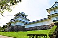
Local attractions
Places of interest
- Kome HyappyoMonument
- Tsuginosuke Kawai Monument in Yukyuzan Park
- Haibu Nagaoka Stadium
- The Niigata Prefectural Museum of Modern Art
- Niigata Prefectural Museum of History
- Yukyuzan Park
- National Government Echigo Hillside Park
- Nagaoka Lyric Hall
- Nagaoka City Local Museum
National Historic Sites
-
 Ote-dori Street and Nagaoka Station
 -
 Quina Saffron Winery
 -
 Hasegawa Family Residence
 -
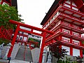 Houtokusan Inari Taisya Shrine
 -
 Nagaoka City Local Museum
 -
 Bull wrestling in Yamakoshi
 -
 Nakayama tunnel
 -
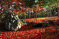 Momijien
 -
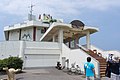 Teradomari Aquarium
 -
 The Niigata Prefectural Museum of Modern Art
 -

-
 Kawai Tsuginosuke Memorial Museum
 -
 Yamamoto IsorokuMemorial Museum
 -
 Ryōkan's grave (Ryusenji)


Festivals
- Nagaoka Festival and Grand Fireworks Festival (August)
- Nagaoka Aki Matsuri (Autumn Festival) and Kome HyappyoFestival (October)
Notable people from Nagaoka
- Ryō Hirohashi (voice actor)
- Tomoko Hoshino (actress)
- El Desperado (professional wrestler)
- Etsu Inagaki Sugimoto (writer)
- philosopher and founder of Toyo University)
- Yuki Kondo (mixed martial artist)
- Jūshirō Konoe (actor)
- Koharu Kusumi (Morning Musume)
- Haruo Minami (Enka singer)
- manga artist)
- Isoroku Yamamoto (Commander of the Imperial Japanese Navy during the first four years of World War II)
- Tomokazu Yoshida (former actor, acupuncturist)
References
- ^ "人口と世帯数 (Population and number of households)". Nagaoka City Website (in Japanese). Archived from the original on 5 August 2020. Retrieved 12 August 2021.
- ^ "プロフイール (Profile)". Nagaoka City Website. Archived from the original on 19 July 2013.
- ^ a b 気象庁 / 平年値(年・月ごとの値). JMA. Retrieved March 24, 2022.
- ^ 観測史上1~10位の値(年間を通じての値). JMA. Retrieved March 24, 2022.
- ^ 観測史上1~10位の値(年間を通じての値). JMA. Retrieved March 24, 2022.
- ^ 気象庁 / 平年値(年・月ごとの値). JMA. Retrieved March 24, 2022.
- ^ "Japan: Niigata Prefecture, Cities, Towns and Villages". City Population. Archived from the original on 12 July 2021. Retrieved 12 August 2021.
- ^ 住民基本台帳人口移動報告年報 (in Japanese). 総務庁統計局. 2005. p. 139.
Nakanoshima-machi, Koshiji-machi, Mishima-machi, Yamakoshi-mura and Oguni-machi were incorporated into Nagaoka-shi as of April 1, 2005.
- ^ "越路町と長岡市との合併 | 長岡市よくある質問(Q&A)". 長岡市. Retrieved 2024-02-04.
平成17年4月1日に南蒲原郡中之島町、三島郡三島町、古志郡山古志村、刈羽郡小国町と一緒に長岡市に編入合併しました。
- ^ "市町村合併に伴う町名変更一覧". Nagaoka City (in Japanese). Retrieved 2024-02-04.
- ^ 住民基本台帳人口移動報告年報 (in Japanese). 総務庁統計局. 2006. p. 135.
Tochio-shi, Washima‐mura, Teradomari‐machi and Yoita‐machi were incorporated into Nagaoka-shi as of January 1, 2006.
- ^ https://www.yomiuri.co.jp/dy/national/20100402TDY03T01.htm[dead link]
- ^ "Sister Cities and Friendship City". niea.or.jp. Nagaoka International Exchange Association. Retrieved 2020-04-07.
External links
- Official Website (in Japanese)
| Niigata |
| |||
|---|---|---|---|---|
| Special cities | ||||
| Cities | ||||
| Districts | ||||
| Former Districts | ||||
| 2,000,000 and more | |
|---|---|
| 1,000,000–1,999,999 | |
| 500,000–999,999 | |
| 200,000–499,999 |
|
| International | |
|---|---|
| National | |
| Geographic | |
| Academics | |