
Nahal Sorek

Naḥal Sorek (
Etymology
Folk etymology mentioned in the Midrash (Numbers Rabbah 9) states that the sorek is a "fruitless tree" (the word ריק req means "empty" in Hebrew), implying a moral lesson and metaphor suggesting that Samson's involvement in his affair with Delilah was eventually "fruitless".
Etymology suggests that "sorek" means "special vine" and refers to the grapes and wines grown in the area.
In the Bible
Nahal Sorek was the place where Delilah lived, and Samson came to meet her for the first time. It was also the place she enticed him to tell her the secret of his strength, and where he was eventually captured by the Philistines:
And Samson went to Gaza ... And it came to pass afterward, that he loved a woman in the brook/valley of Sorek, whose name was Delilah. And the lords of the Philistines came up to her, and said to her: 'Entice him, and see wherein his great strength lies, and by what means we may prevail against him, that we may bind him to afflict him ...
— Judges 16[4]
Land property along the river
In 1921, lands that bounded Nahal Sorek (Wadi es Surar / Wad Issarar) which passed to the south of Artuf were designated as "Mara land," meaning, pasture land reserved primarily for the use of the adjoining villages.[5]
Road and railway

In the 19th century, Nahal Sorek served as an important connection between the two major cities in the area,
Nature Reserve
The Nahal Sorek Nature Reserve, first declared in 1965, and since expanded, spans over 11000 dunams,[6] from the Avshalom Cave Nature Reserve near Beit Shemesh, to moshav Nes Harim.
Desalination plants
Near the mouth of the Sorek River are two large seawater desalination plants, Palmachim and Sorek, the latter being, when used at full capacity, the largest of its kind in the world (as of 2013).[7]
Gallery
-
 Distant mountain rising above Nahal Sorek
 -
 Forested mountains above Nahal Sorek
 -
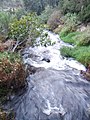 Running waters of brook in Nahal Sorek
 -
 Looking towards the east from Tur Shimon
 -
 View of Tur Shimon in Nahal Sorek
 -
 Ancient wall of Tur Shimon (Hurvat Tura)
 -
 Remnants of material culture in Nahal Sorek
 -
 View of Nahal Sorek from the ruins of Tur Shimon
 -
 Tur Shimon rising from Nahal Sorek
 -
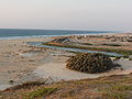 The place where the Sorek valley empties into the sea
 -
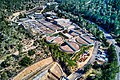 Sorek Wastewater Treatment Plant in Nahal Sorek, near Road 386


_in_Nahal_Sorek.jpg)


.jpg)
.jpg)


See also
- Nahal Sorek Regional Council, administrative district in central Israel situated along Sorek Valley
- Soreq Nuclear Research Center, a research and development institute
- Timnah, Philistine city mentioned in the Bible, identified with Tel Batash in the Sorek Valley
- Zorah, biblical town in Judah, identified with a site overlooking the Sorek Valley
References
- ^ Protecting The Environment
- ^ Office for Subject Cataloging Plicy, Collections Services (1992). Library of Congress Subject Headings. Vol. IV Q-Z (15 ed.). Washington, D.C.: Library of Congress. Retrieved 24 May 2018.
- ISBN 9780472052127. Retrieved 24 May 2018.
....the Soreq riverbed, which on the British map I brought them is called Wadi Qalunya.
- ^ Judges 16:1, 16:4–5
- ^ Israel Government Archives (Land Registry Office of Jerusalem - Register of Deeds), p. 39 (Mandatory Organizations); letter written by M. Doukhan, Advocate, on 19 January 1941. "Mara lands," same as "Arazi Metruké" in the Ottoman Land Code, of which there were two kinds: the first being "pasture land" that has been allotted to a village or number of villages, and which cannot be cultivated or turned into private property or belong to individuals (Art. 97 of the Ottoman Land Code). Such lands were used principally as pasture land for grazing; the second being "pasture land" that was privately owned, and which could be used for general cultivation, such as ploughing and sowing (Article 5 of the Law of Disposition of Immovable Property of the year 1913 (1331)), without the necessity of obtaining special authority.
- ^ "List of National Parks and Nature Reserves" (PDF) (in Hebrew). Israel Nature and Parks Authority. Archived from the original (PDF) on 2012-03-13. Retrieved 2010-09-27.
- ^ Sales, Ben (May 30, 2013) With desalination, a once unthinkable water surplus is possible. The Times of Israel
| International | |
|---|---|
| National | |