
Nanchang
Nanchang
南昌市 | |
|---|---|
Camphor Laurel | |
| Website | nc |
| Nanchang | ||
|---|---|---|
Tâi-lô | Lâm-tshiong | |
Nanchang[a] is the capital of Jiangxi Province, China. Located in the north-central part of the province and in the hinterland of Poyang Lake Plain, it is bounded on the west by the Jiuling Mountains, and on the east by Poyang Lake. Because of its strategic location connecting the prosperous East and South China, it has become a major railway hub in Southern China in recent decades.
As the
History
This section needs additional citations for verification. (February 2013) |


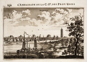
The territories encompassing modern-day Jiangxi Province—including Nanchang—was first incorporated into China during the Qin dynasty, when it was conquered from the Baiyue peoples and organized as Jiujiang Commandery (Chinese: 九江郡).[6] In 201 BC, during the Han dynasty, the city was given the Chinese name Nanchang and became the administrative seat of Yuzhang Commandery (豫章郡), and was governed by Guan Ying, one of Emperor Gaozu of Han's generals.[6] The name Nanchang means "southern flourishing", derived from a motto of developing what is now southern China that is traditionally attributed to Emperor Gaozu himself.[6]
In AD 589, during the
In 653 the
In 959, under the
During the Yuan Dynasty, it might have been the centre of porcelain trade[10]
During the reign of the Wanli Emperor of the Ming dynasty, it housed relatives of the emperor who had been exiled because they were potential claimants of the imperial throne, members of the imperial family constituting about one quarter of the city's population; as a result of this, Matteo Ricci came here when trying to gain entry to Beijing.[11]
In the 1850s it suffered considerably as a result of the Taiping Rebellion (1850–64), and its importance as a commercial centre declined as the overland routes to Canton were replaced by coastal steamship services in the latter half of the 19th century. Nanchang has, however, remained the undisputed regional metropolis of Jiangxi.
On August 1, 1927, Nanchang was the site of one of a series of insurrections organized by the
In 1939, the
By 1949 Nanchang was still essentially an old-style administrative and commercial city, with little industry apart from
Since 1949 Nanchang has been extensively industrialized. It is now a large-scale producer of
Geography
This section needs expansion. You can help by adding to it. (May 2013) |

Nanchang is located in inland southeastern China, 130 km (81 mi) south of the

Climate
Nanchang has a humid subtropical climate (Köppen Cfa) with four distinct seasons. Winters are short and cool with occasional frosts; it begins somewhat sunny and dry but becomes progressively wetter and more overcast. Spring begins especially gloomy, and from April to June, each month has more than 220 mm (8.7 in) of rainfall. Summer is long and humid, with amongst the highest temperatures of any Chinese provincial capital, and with the sun shining close to 60 percent of the time in July and August, is the sunniest time of year. Autumn is warm to mild with the lowest rainfall levels of the year. The monthly 24-hour average temperature ranges from 5.9 °C (42.6 °F) in January to 29.6 °C (85.3 °F) in July, while the annual mean is 18.5 °C (65.3 °F). Annual precipitation stands at around 1,704 mm (67 in); with monthly percent possible sunshine ranging from 27 percent in March to 56 percent in August, the city receives 1,809 hours of sunshine annually in average. Extremes since 1951 have ranged from −9.7 °C (15 °F) on 29 December 1991 to 40.6 °C (105 °F) on 23 July 1961.[15]
| Climate data for Nanchang (1991–2020 normals, extremes 1951–present) | |||||||||||||
|---|---|---|---|---|---|---|---|---|---|---|---|---|---|
| Month | Jan | Feb | Mar | Apr | May | Jun | Jul | Aug | Sep | Oct | Nov | Dec | Year |
| Record high °C (°F) | 25.3 (77.5) |
28.7 (83.7) |
32.5 (90.5) |
34.6 (94.3) |
36.5 (97.7) |
37.7 (99.9) |
40.6 (105.1) |
39.7 (103.5) |
38.6 (101.5) |
38.6 (101.5) |
32.3 (90.1) |
26.1 (79.0) |
40.6 (105.1) |
| Mean daily maximum °C (°F) | 9.2 (48.6) |
12.1 (53.8) |
16.1 (61.0) |
22.6 (72.7) |
27.3 (81.1) |
29.9 (85.8) |
33.7 (92.7) |
33.3 (91.9) |
29.6 (85.3) |
24.6 (76.3) |
18.3 (64.9) |
11.9 (53.4) |
22.4 (72.3) |
| Daily mean °C (°F) | 5.9 (42.6) |
8.4 (47.1) |
12.2 (54.0) |
18.4 (65.1) |
23.3 (73.9) |
26.2 (79.2) |
29.6 (85.3) |
29.2 (84.6) |
25.6 (78.1) |
20.3 (68.5) |
14.2 (57.6) |
8.2 (46.8) |
18.5 (65.2) |
| Mean daily minimum °C (°F) | 3.5 (38.3) |
5.7 (42.3) |
9.4 (48.9) |
15.1 (59.2) |
20.0 (68.0) |
23.3 (73.9) |
26.4 (79.5) |
26.2 (79.2) |
22.6 (72.7) |
17.2 (63.0) |
11.1 (52.0) |
5.4 (41.7) |
15.5 (59.9) |
| Record low °C (°F) | −7.7 (18.1) |
−9.3 (15.3) |
−1.7 (28.9) |
2.4 (36.3) |
10.0 (50.0) |
14.8 (58.6) |
18.9 (66.0) |
19.5 (67.1) |
13.3 (55.9) |
3.5 (38.3) |
−0.8 (30.6) |
−9.7 (14.5) |
−9.7 (14.5) |
| Average precipitation mm (inches) | 83.6 (3.29) |
95.3 (3.75) |
191.5 (7.54) |
213.0 (8.39) |
218.4 (8.60) |
341.6 (13.45) |
176.3 (6.94) |
120.0 (4.72) |
65.3 (2.57) |
49.8 (1.96) |
92.4 (3.64) |
56.3 (2.22) |
1,703.5 (67.07) |
| Average precipitation days (≥ 0.1 mm) | 12.9 | 12.8 | 17.3 | 16.5 | 15.6 | 16.1 | 11.0 | 10.5 | 6.6 | 6.7 | 9.5 | 9.5 | 145 |
| Average snowy days | 3.0 | 1.8 | 0.6 | 0 | 0 | 0 | 0 | 0 | 0 | 0 | 0 | 1.0 | 6.4 |
| Average relative humidity (%)
|
74 | 75 | 78 | 77 | 76 | 81 | 75 | 74 | 73 | 68 | 72 | 70 | 74 |
| Mean monthly sunshine hours | 87.1 | 90.0 | 101.1 | 132.7 | 155.5 | 145.3 | 237.5 | 227.5 | 191.0 | 175.3 | 138.1 | 127.8 | 1,808.9 |
| Percent possible sunshine | 27 | 28 | 27 | 34 | 37 | 35 | 56 | 56 | 52 | 50 | 43 | 40 | 40 |
| Source: China Meteorological Administration[16][17][18] | |||||||||||||
As of the
Administration

| Map | |||||||||||
|---|---|---|---|---|---|---|---|---|---|---|---|

Donghu Xihu Qingyunpu Xinjian Qingshanhu Honggutan | |||||||||||
| Division code[21] | English | Chinese | Pinyin | Area in km2[22] | Seat | Postal code | Subdivisions[23] | ||||
Subdistricts
|
Towns
|
Townships
|
Residential communities | Villages | |||||||
| 360100 | Nanchang | 南昌市 | Nánchāng Shì | 7194[24] | Honggutan District |
330000 | 32 | 49 | 31 | 625 | 1161 |
| 360102 | Donghu District
|
东湖区 | Dōnghú Qū | 30 | Gongyuan Subdistrict (公园街道) | 330000 | 9 | 159 | 21 | ||
| 360103 | Xihu District
|
西湖区 | Xīhú Qū | 43 | Chaoyangzhou Subdistrict (朝阳洲街道) | 330000 | 10 | 1 | 136 | 13 | |
| 360104 | Qingyunpu District
|
青云谱区 | Qīngyúnpǔ Qū | 40 | Sanjiadian Subdistrict (三家店街道) | 330000 | 5 | 1 | 63 | 12 | |
| 360111 | Qingshanhu District
|
青山湖区 | Qīngshānhú Qū | 250 | Jingdong (京东镇) | 330000 | 3 | 6 | 116 | 101 | |
| 360112 | Xinjian District
|
新建区 | Xīnjiàn Qū | 2160 | Changleng (长堎镇) | 330100 | 10 | 9 | 39 | 300 | |
| 360113 | Honggutan District
|
红谷滩区 | Hónggǔtān Qū | Shajing Subdistrict (沙井街道) | 330100 | 2 | 1 | ||||
| 360121 | Nanchang County | 南昌县 | Nánchāng Xiàn | 1811 | Liantang (莲塘镇) | 330200 | 11 | 7 | 47 | 311 | |
| 360123 | Anyi County | 安义县 | Ānyì Xiàn | 660 | Longjin (龙津镇) | 330500 | 7 | 3 | 16 | 105 | |
| 360124 | Jinxian County | 进贤县 | Jìnxián Xiàn | 1946 | Minhe (民和镇) | 331700 | 9 | 2 | 37 | 263 | |
- Honggutan New District(红谷滩新区) is an economic management area and not a formal administrative division.
Economy

Nanchang is a regional hub for agricultural production in
In 2017, the city's gross regional product (GDP) was 500.319 billion yuan(US$80.03 billion ), an increase of 9.0% over the previous year. The primary industry's added value was 19.213 billion yuan, an increase of 4.0%; the secondary industry's added value was 266.61 billion yuan, an increase of 8.4%; The added value of the three industries was 214.496 billion yuan, an increase of 10.2%. The per capita GDP of 81,598 yuan was converted to 12,285 US dollars according to the average annual exchange rate, and the total fiscal revenue for the year was 78.282 billion yuan, an increase of 14.3% over the previous year.

The GDP of Nanchang in 2008 was 166 billion Yuan (US$24.3 billion ). The GDP per capita was 36,105 Yuan (US$5,285). The total value of imports and exports was 3.4 billion US dollars. The total financial revenue was 23 billion Yuan.[27]
Industrial zones
National level development zones[28]
- Nanchang Export Processing Zone
Nanchang National Export Expressing Zone is located in Nanchang Hi-Tech Industrial Development Zone, it was approved by the State Council on May 8, 2006, and passed the national acceptance inspection on Sep 7th, 2007. It has a planning area of 1 km2 and now has built 0.31 km2. It enjoys simple and convenient customs clearances, and special preferential policies both for Nanchang National Export Expressing Zone and NCHDZ.[29]
- Nanchang National High-tech Industrial Development Zone
Nanchang National High-tech Industrial Development Zone (NCHDZ for short hereafter) is the only national grade high-tech zoned in Jiangxi, it was established in Mar. 1991. The zone covers an area of 231 km2 (89 sq mi), in which 32 km2 (12 sq mi) have been completed. NCHDZ possesses unique nature condition and sound industry foundation of accepting electronics industry. NCHDZ has brought 25 percent industrial added value and 50 percent industrial benefit and tax to Nanchang city by using only 0.4 percent land area.[30]
- Nanchang Economic and Technological Development Zone[31]
Provincial level development zones[28]
- Jiangxi Shanghai Economic and Technological Development Zone
- Nanchang Yingxiong Economic and Technological Development Zone
Special economic district[28]
- Honggutan New DistrictGanJiang New District
Transportation

Nanchang has an advantageous geographic location and convenient transportation. It is praised as the “three rivers and five lakes, and the control of the finer and better lakes”[citation needed]. It relies on high-speed railways and aviation hubs to connect three important economic circles (Yangtze River Delta, Pearl River Delta, Inter-provincial traffic corridors in Haixi District). Nanchang is one of the country's comprehensive transportation hubs and one of the most important integrated transportation hubs in Jiangxi.
Rail
The Nanchang is an important rail hub for southeastern China. The
Air

Nanchang Changbei International Airport (KHN) built in 1996 is the main international airport. It is situated in Lehua Town, 26 kilometres north of the CDB area. Changbei International Airport is the only one in Jiangxi Province which has an international air route. The airport is connected to major mainland cities such as Shenzhen, Guangzhou, Haikou, Shanghai and Beijing.[32] There is a military/civilian airport near Liantang, Nanchang County.
Nanchang Changbei International Airport is the largest airport in Jiangxi Province. In 2014, Nanchang Changbei Airport opened up to 10 international destinations. The airport handled 7.25 million passengers in 2014, an increase of 6.3%. Among them, the Nanchang aviation port exceeded 280,000 passengers, an increase of nearly 40%, becoming the airport's traffic volume. The important force of growth, and will continue to maintain rapid development. On December 6, 2017, the annual passenger throughput of Nanchang Airport exceeded 10 million passengers, making it the nation's 31st “million-grade airport”. In 2017, passenger throughput reached 10.93 million, a year-on-year increase of 39.0%, a net increase of passenger throughput of 3.07 million passengers; flights took off and 89,000 vehicles, a year-on-year increase of 35.2%; and cargo and mail throughput of 52,000 tons, an increase of 3.3%. In order to cooperate with the construction of the Beijing-Kowloon high-speed railway and Nanchang North Station airport complex transportation hub, large-scale expansion and upgrades are being carried out recently.
Road
The road transport infrastructure in Nanchang is extensive. A number of national highways cross through the city. They are the National roads No.105 from Beijing to Zhuhai, No.320 from Shanghai to Kunming, and No.316 from Fuzhou to Lanzhou. The major transport companies that operate in Nanchang are the Chang'an Transport Company Limited, the Nanchang Long-distance Bus Station, and the Xufang Bus Station. National Highway G70 crosses through Nanchang. Nanchang also built its round-city highway G70_01 opening in 2007.
The Nanchang Long-distance Bus Station serves long-distance routes to Nanjing, Shenzhen, Hefei and other cities outside Jiangxi Province. The Xufang Bus Station operates routes to cities, towns and counties within Jiangxi Province.[32]
Metro
Nanchang Rail Transit is the first rail transportation system in Jiangxi Province, the world's leading MRT system, the second batch of rail transit cities in China. It will connect Nanchang's main downtown area and each satellite city, the Nanchang Metro has been in service since 26th Dec 2015. Nanchang is the 25th city in mainland China to put into operation. The planning of Nanchang rail transit project started in 1999 and was officially started in 2009. The first phase of the No. 1 and No. 2 lines was 50,996 kilometers (the first line is the underground line). Line 1 was officially opened and operated at the end of 2015, and Line 2 of the “First Section” began trial operation on August 19, 2017.
Water
Nanchang is situated on the Gan River, the Fu River, Elephant Lake, Qingshan Lake, and Aixi Lake. Hence the water routes for Nanchang are critically important for the economy, trade and shipping. Nanchang Port is the biggest port on the Gan River. Passengers can take Nanchang Port and travel by boat to the Jinggang Shan and Tengwang Pavilion. There are passenger ships that also visit Poyang Lake, Stone Bell Hill, Poyang Lake Bird Protection Area, Dagu Hill and other attractions.
Landmarks

- Tengwang Pavilion, a towering pavilion dating to 653, on the east bank of the Gan River and is one of "the Four Great Towers of China"
- Poyang Lake, the largest fresh water lake in China, it is also called "the Migrator Birds Paradise".
- Honggutan District[33]
- Qiushui Square, established on 28 January 2004 with the largest music fountain group with music in Asia.[citation needed]
- Jiangxi Provincial Museum and Bada Shanren Exhibition Hall
- People's Park, the largest park in downtown Nanchang[34]
- Bayi Square and Memorial, at the center of Nanchang, commemorates the founding of the Nanchang Uprisingof 1 August (Ba Yi in Mandarin) in 1927, which led to the formation of the People's Republic of China in 1949.
Education
Colleges and universities (note that institutions without full-time bachelor programs are not listed):
- Jiangxi University of Finance and Economics (江西财经大学)
- Nanchang University (南昌大学)
- Jiangxi Normal University (江西师范大学)
- Nanchang Hangkong University (南昌航空大学)
- Jiangxi Agricultural University (江西农业大学)
- East China Jiaotong University (华东交通大学)
- East China University of Technology, Nanchang Campus (东华理工大学)
- Jiangxi Institute of Traditional Chinese Medicine(江西中医学院)
- Nanchang Institute of Technology (南昌工程学院)
- Jiangxi Science and Technology Normal University (江西科技师范学院)
- Jiangxi Manufacturing and Vocational College (江西制造职业技术学院)
- Jiangxi University of Traditional Chinese Medicine (江西中医药大学)
High schools:
- Affiliated Middle School of Jiangxi Normal University (江西师范大学附属中学)
- Nanchang No.2 Middle School (南昌市第二中学)
- Nanchang No.1 Middle School (南昌市第一中学)
- Nanchang No.3 Middle School (南昌市第三中学)
- Nanchang No.10 Middle School (南昌市第十中学)
International schools:
- Nanchang International School (南昌国际学校)
Sport
Nanchang is the site of Jiangxi International Women's Tennis Open.[35]
Notes
- ^ UK: /nænˈtʃæŋ/, US: /nɑːnˈtʃɒŋ/;[3] Chinese: 南昌; pinyin: Nánchāng
References
- ^ "China: Jiāngxī (Prefectures, Cities, Districts and Counties) - Population Statistics, Charts and Map".
- ISBN 978-7-5037-7809-4. Archived from the originalon 2018-05-11. Retrieved 2017-06-05.
- ^ "Nanchang". Lexico UK English Dictionary. Oxford University Press. Archived from the original on May 19, 2021.
- ^ Schwartz, Benjamin, Chinese Communism and the Rise of Mao, Harper & Row (New York: 1951), p. 93.
- ^ "Leading 200 science cities | Nature Index 2022 Science Cities | Supplements | Nature Index". www.nature.com. Retrieved 2022-11-27.
- ^ ISBN 9787532617432.
- ^ Wang: 236-246.
- ^ Wang: 1.
- ^ Wang: 31.
- ^ "Wang Dayuan - Singapore History". eresources.nlb.gov.sg. Retrieved 2021-04-01.
- ISBN 0-571-22517-9, 2011, p. 103
- ^ Hsu Long-hsuen and Chang Ming-kai, History of the Sino-Japanese War (1937–1945), 2nd Ed., 1971. Translated by Wen Ha-hsiung, Chung Wu Publishing; 33, 140th Lane, Tung-hwa Street, Taipei, Taiwan Republic of China. pp. 293-300 Map. 14-15
- ^ Peattie, M., Drea, E. & Ven, H. (2011). The battle for China : essays on the military history of the Sino-Japanese War of 1937-1945. Stanford, Calif: Stanford University Press.
- ^ http://surfcity.kund.dalnet.se/sino-japanese.htm Archived 2015-08-13 at the Wayback Machine Sino-Japanese Air War 1937–45
- ^ "无标题文档". Archived from the original on 2013-03-18. Retrieved 2013-02-18.
- ^ 中国气象数据网 – WeatherBk Data (in Chinese (China)). China Meteorological Administration. Retrieved April 15, 2020.
- ^ "Experience Template" CMA台站气候标准值(1991-2020) (in Chinese). China Meteorological Administration. Retrieved 12 September 2023.
- ^ 中国气象局 国家气象信息中心 (in Simplified Chinese). China Meteorological Administration. August 2010. Archived from the original on 2013-03-18. Retrieved 2010-05-04.
- ^ "Main Data of the Seventh National Population Census". www.stats.gov.cn. Retrieved 24 January 2024.
- ^ "Modern Urban District - Nanchang Municipal People's Government". www.nc.gov.cn. Retrieved 24 January 2024.
- National Bureau of Statistics of the People's Republic of China. 2012. Archived from the originalon 2013-04-05. Retrieved 2013-01-27.
- ^ 《贵阳统计年鉴2011》[full citation needed]
- ^ 《中国民政统计年鉴2011》[full citation needed]
- Ministry of Land and Resources.[citation needed]
- ^ "Jiangling Motors Corporation, Ltd. website". Archived from the original on 2008-12-28. Retrieved 2009-01-01.
- ^ [1] Archived April 14, 2010, at the Wayback Machine
- ^ "Jiangxi". Unescap.org. Archived from the original on 2004-06-26. Retrieved 2012-01-16.
- ^ a b c "NanChang China". English.nc.gov.cn. Archived from the original on 2012-03-25. Retrieved 2012-01-16.
- ^ "Nanchang Export Processing Zone". RightSite.asia. Archived from the original on 2012-05-03. Retrieved 2012-01-16.
- ^ "Nanchang High-Tech Industrial Development Zone". RightSite.asia. Archived from the original on 2012-05-03. Retrieved 2012-01-16.
- ^ "Nanchang Economic & Technological Development Zone". RightSite.asia. Archived from the original on 2012-05-03. Retrieved 2012-01-16.
- ^ a b "Nanchang Transportation, Get to the City: by Air, Train, Bus, Water". Travelchinaguide.com. Archived from the original on 2011-10-27. Retrieved 2012-01-16.
- ^ "China claims world's largest Ferris wheel - Boston.com". Archived from the original on May 1, 2007.
- ^ 南昌-人民公园 [People's Park, Nanchang] (in Simplified Chinese). Xinhua. 2008-04-01. Archived from the original on 2011-07-18. Retrieved 2014-05-04.
- ^ "WTA". Archived from the original on 2018-10-03. Retrieved 2018-10-03.
- Wang, Qiaolin (王巧林 (1996). 江南名胜 滕王阁 [Jiangnan Famous Site: The Pavilion of Prince Teng]. Baihuazhou Literary Press (百花洲文艺出版社. ISBN 7-80579-797-8.; 247 pages