
Nanda Devi
| Nanda Devi | |
|---|---|
List of Indian states and territories by highest point | |
| Coordinates | 30°22′33″N 79°58′15″E / 30.37583°N 79.97083°E[1][2] |
| Geography | |
 Nanda Devi Location in India  Nanda Devi Nanda Devi (India) | |
| Location | Garhwal Himalaya |
| Climbing | |
| First ascent | 29 August 1936 by Noel Odell and Bill Tilman[3][4] |
| Easiest route | south ridge: technical rock/snow/ice climb |
Nanda Devi is the second-highest mountain in
Nanda Devi was considered the highest mountain in the world before computations in 1808 proved Dhaulagiri to be higher. It was also the highest mountain in India until 1975, when Sikkim, an independent kingdom until 1948 and a protectorate of India thereafter, became a state of India. It is located in the Chamoli district of Uttarakhand, between the Rishiganga valley on the west and the Goriganga valley on the east.
The peak, whose name means "Bliss-Giving Goddess",
Description and notable features
Nanda Devi is a
state.In addition to being the
On the northern side of the massif lies the
Exploration and climbing history

The ascent of Nanda Devi necessitated fifty years of arduous exploration in search of a passage into the Sanctuary. The outlet is the Rishi Gorge, a deep, narrow canyon which is very difficult to traverse safely, and is the biggest hindrance to entering the Sanctuary; any other route involves difficult passes, the lowest of which is 5,180 m (16,990 ft). Hugh Ruttledge attempted to reach the peak three times in the 1930s and failed each time. In a letter to The Times he wrote that 'Nanda Devi imposes on her votaries an admission test as yet beyond their skill and endurance', adding that gaining entry to the Nanda Devi Sanctuary alone was more difficult than reaching the North Pole.[1] In 1934, the British explorers

When the mountain was later climbed in 1936 by a British-American expedition, it became the highest peak climbed by man until the 1950 ascent of Annapurna, 8,091 metres (26,545 ft). (However, higher non-summit elevations had already been reached by the British on Mount Everest in the 1920s, and it is possible that George Mallory reached Everest's summit in 1924.) It also involved steeper and more sustained terrain than had been previously attempted at such a high altitude.[4] The expedition climbed the south ridge, also known as the Coxcomb Ridge, which leads relatively directly to the main summit.[3] The summit pair were H. W. Tilman and Noel Odell; Charles Houston was to be in place of Tilman, but he contracted severe food poisoning. Noted mountaineer and mountain writer H. Adams Carter was also on the expedition, which was notable for its small scale and lightweight ethic: it included only seven climbers, and used no fixed ropes, nor any Sherpa support above 6,200 m (20,300 ft). Eric Shipton, who was not involved in the climb itself, called it "the finest mountaineering achievement ever performed in the Himalaya."[4]
After abortive attempts by Indian expeditions in 1957 and 1961, the second ascent of Nanda Devi was accomplished by an Indian team led by N. Kumar in 1964, following the Coxcomb route.
CIA mission
From 1965 to 1968, attempts were made by the
Subsequent climbs

A difficult new route, the northwest buttress, was climbed by a 13-person team in 1976. Three Americans, John Roskelley, Jim States and Louis Reichardt, summited on 1 September. The expedition was co-led by Reichardt, H. Adams Carter (who was on the 1936 climb,) and Willi Unsoeld, who climbed the West Ridge of Everest in 1963. Unsoeld's daughter, Nanda Devi Unsoeld, who was named after the peak, died on this expedition.[10][11] She had been suffering from "diarrhea and flare-up of an inguinal hernia, which had shown up originally on the second day of the approach march", and had been at 7,200 metres (23,600 ft) for nearly five days.[12]
In 1980, the Indian Army Corps of Engineers made an unsuccessful attempt.
This was followed in 1981 by another Indian Army expedition of the Parachute Regiment, which attempted both main and eastern peaks simultaneously. The expedition had placed a memorial to Nanda Devi Unsoeld at the high altitude meadow of Sarson Patal prior to the attempt. The successful attempt lost all its summiteers.
In 1993, a 40-member team of the Indian Army from the Corps of Engineers was given special permission. The aim of the expedition was multifold: to carry out an ecological survey, clean up the refuse left behind by previous expeditions, and scale the summit. The team led by Lt Col V.K. Bhatt included a number of wildlife scientists and ecologists from Wildlife Institute of India, Salim Ali Centre for Ornithology and Natural History, World Wide Fund for Nature and Govind Ballabh Pant Institute for Himalayan Environment and Development amongst others. The expedition carried out a comprehensive ecological survey and removed from the park, by porter and helicopter, over 1,000 kilogrammes of litter. Additionally, five summiteers reached the summit: Amin Naik, Anand Swaroop, G. K. Sharma, Didar Singh and S. P. Bhatt.[13]
Recent history and conservation

After the re-opening of the sanctuary in 1974 to foreign climbers, trekkers and locals, the fragile ecosystem was soon compromised by firewood cutting, littering and grazing. Serious environmental problems were noted as early as 1977, and the sanctuary was closed again in 1983.
2021 flood
On 7 February 2021 it was reported that a portion of the Nanda Devi glacier
Gallery
-
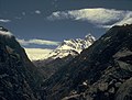
 Nanda Devi peak view from the west near Deodi camp in Rishi Ganga gorge
 -
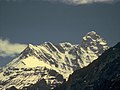
 Nanda Devi peak view from outer Sanctuary near Bujgara
 -
 Nanda Devi peak view from outer Sanctuary near Bujgara closeup
 -
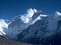
 Nanda Devi peaks wide view SE from slopes of Kalanka in Changabang Gal
 -
 Nanda Devi peak N face view from slopes of Deo Damla
 -
 Nanda Devi north face viewed from Deo Damla approach valley


See also
References
- ^ a b c "High Asia I: The Karakoram, Pakistan Himalaya and India Himalaya (north of Nepal)". Peaklist.org. Retrieved 28 May 2014.
- ^ The Himalayan Index gives the coordinates of Nanda Devi as 30°22′12″N 79°58′12″E / 30.37000°N 79.97000°E.
- ^ ISBN 0-8212-2502-2, pp. 254–257.
- ^ ISBN 0-340-64931-3.
- ^ "Kanchenjunga", Encyclopedia Britannica, 17 April 2023, retrieved 13 May 2023,
Kanchenjunga, also spelled Kangchenjunga or Kinchinjunga, Nepali Kumbhkaran Lungur, world's third highest mountain, with an elevation of 28,169 feet (8,586 metres). It is situated in the eastern Himalayas on the border between Sikkim state, northeastern India, and eastern Nepal, 46 miles (74 km) north-northwest of Darjiling
- ^ Kumaoun -Himalaya-Ost, 1:150,000 scale topographic map, prepared in 1992 by Ernst Huber for the Swiss Foundation for Alpine Research, based on maps of the Survey of India.
- ^ Garhwal-Himalaya-Ost, 1:150,000 scale topographic map, prepared in 1992 by Ernst Huber for the Swiss Foundation for Alpine Research, based on maps of the Survey of India.
- ^ a b Ranvijay Singh Hada (18 September 2020). "Nanda Devi's Nuclear Secret and a Botched CIA Operation". Retrieved 22 February 2021.
- ^ Jose, Vinod K. (1 December 2010). "River Deep Mountain High". Caravan Magazine. Retrieved 20 May 2013.
- ISBN 0-89886-739-8
- ^ American Alpine Journal, 1977.
- ^ Unsoeld, Willie (1977). "Darkness at Noon: The life and death of Nanda Devi Unsoeld". THE AMERICAN ALPINE JOURNAL.
- ^ ISBN 81-224-0752-8
- ^ Nanda Devi and Valley of Flowers National Parks – UNESCO World Heritage Centre
- ^ "Nanda Devi Bio Diversity Conservation and Ecotourism Declaration" (PDF). icimod.org/. 14 October 2001. Retrieved 22 December 2018.
- ^ Misra, Neelesh (15 September 2006). "Nanda Devi opens door". Hindustan Times. Retrieved 22 December 2018.
- ISSN 0971-751X. Retrieved 8 February 2021.
- ISSN 0261-3077. Retrieved 8 February 2021.
Books
- ISBN 0-14-024045-4.
- ISBN 0-7006-1223-8.
- Jose, Vinod (2010). River Deep, Mountain High, The Caravan Magazine.
- ISBN 978-1463529390
- Roskelley, John. (2000). Nanda Devi: The Tragic Expedition, The Mountaineers Books. ISBN 0-89886-739-8.
- Sanan, Deepak. (1995) Nandadevi – Restoring Glory – New Age International (Wiley Eastern Ltd), New Delhi. ISBN 81-224-0752-8.
- ISBN 0-89886-721-5.
- Sircar, J. (1979) Himalayan Handbook, (private pub., Calcutta).
- Takeda, Peter. (2006) An Eye at the Top of the World: The Terrifying Legacy of the Cold War's Most Daring C.I.A. Operation, Thunder's Mouth Press. ISBN 1-56025-845-4.
- Thomson, Hugh (2004) Nanda Devi: A Journey to the Last Sanctuary, Weidenfeld & Nicolson ISBN 0-297-60753-7
- Tilman, H. W., The Ascent of Nanda Devi, Cambridge University Press. 1937.
External links
- "Kargil war hero missing in Nanda Devi snowstorm" Indianexpress.com
- Nanda Devi Campaign – web site of the local inhabitants
- "Nanda Devi". Peakware.com. Archived from the original on 4 March 2016. – photos
- Unesco World Heritage Site on Nanda Devi
- GMVN – Uttarakhand Tourism page on Nanda Devi National Park
- 'High heaven: a trek to the top of the world' The Independent- article describing the Nanda Devi Sanctuary
| International | |
|---|---|
| National | |