
Nanded district
Nanded District | |
|---|---|
| Government | |
| • Type | District Council (Janpad Panchayat) |
| • Body | Nanded Zilha Parishad |
| • Guardian Minister | Girish Mahajan (Cabinet Minister MH) |
| • Office bearers |
|
| • DM cum Collector |
|
| • CEO, Zilla Parishad |
|
| • DFO cum Conservator |
|
| Area | |
| • Total | 10,528 km2 (4,065 sq mi) |
| Population (2011) | |
| • Total | 3,361,292 |
| • Density | 320/km2 (830/sq mi) |
| • crores (2019-20)[3] | |
| Website | nanded |
Nanded district (Marathi pronunciation:
is the district headquarters.History
Geography
The district of Nanded lies between 180 15' to 190 55' North latitudes and 770 to 78025' East longitudes. It covers an area of 10,332 sq km. Nanded District lies in the eastern part of Maharashtra state as well as the eastern portion of
Nanded is bounded on the north by Yavatmal district of the Vidarbha region, with Latur on south-west, Parbhani and Hingoli districts on the west. On the eastern side lies Adilabad, Nirmal, Nizamabad and Kamareddy districts of Telangana state, and on the south lies Bidar of Karnataka state. The area presents undulating topography with uneven hills, plateau, gentle slopes and valley planes.
The Godavari River flows through the district. Physio-graphically, the district can be divided into 2 major parts, the hilly region on the North and North East and low-lying area on the banks of the rivers Godavari, Manjra, Manyad, Penganga.
Demographics
| Year | Pop. | ±% p.a. |
|---|---|---|
| 1901 | 550,261 | — |
| 1911 | 671,066 | +2.00% |
| 1921 | 649,825 | −0.32% |
| 1931 | 706,773 | +0.84% |
| 1941 | 784,289 | +1.05% |
| 1951 | 883,531 | +1.20% |
| 1961 | 1,079,674 | +2.03% |
| 1971 | 1,397,762 | +2.62% |
| 1981 | 1,749,334 | +2.27% |
| 1991 | 2,330,374 | +2.91% |
| 2001 | 2,876,259 | +2.13% |
| 2011 | 3,361,292 | +1.57% |
| source:[4] | ||
According to the
Languages
At the time of the
Economy
In 2006 the
Industrial Estates are located in Nanded, Dharmabad, Loha, Degloor, Kinwat, Krushnoor (SEZ).
Governance
Members of Parliament
- Nanded)
- Latur)
- Hingoli)
Guardian Minister
| Guardian Minister for Nanded District | |
|---|---|
| पालकमंत्री-नांदेड जिल्हा करीता | |
Chief Minister of Maharashtra | |
| Term length | 5 years / No time limit |
| Website | mumbaicity |
List of Guardian Minister
| Name | Term of office |
|---|---|
| Ramdas Kadam | 31 October 2014 - 8 November 2019 |
| Ashok Chavan | 9 January 2020 - 29 June 2022 |
| Girish Mahajan | 24 September 2022 - Incumbent |
Culture
Nanded is mentioned in the
The
-
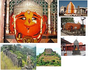 Temples and forts in Mahur, Nanded district
 -
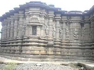 Sidhheshwar Temple near Hottal, Nanded district
 -
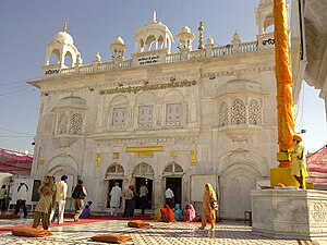 Hazur Sahib, a Sikh shrine located in the Nanded city


Education
- Swami Ramanand Teerth Marathwada University (SRTMU), located in Nanded, was established in 1994 as a state public university of Maharashtra state.
- Dr. Shankarrao Chavan Government Medical College
- Shri Guru Gobind Singhji Institute of Engineering and Technology
Administration
District Collectorate
| District Magistrate / Collector, Nanded | |
|---|---|
| जिल्हाधिकारी तथा जिल्हादंडाधिकारी, नांदेड | |
 Emblem of India | |
Incumbent Shri. Abhijeet Raut (IAS) since 2022 | |
| Residence | Civil Lines, Nanded |
| Appointer | Government of Maharashtra |
| Term length | 3 yrs. (Only once) |
| Website | nanded |
List of District Collector
| Name | Term of office |
|---|---|
| Shrikar Pardeshi | 2009 - 2012 |
| Vipin Itankar | 2020 - incumbent |
Superintendent of Police
| logo = Maharashtra Police Insignia (India).svg | logocaption = Emblem of the Maharashtra Police Department
Notable people
- Vaman Pandit, a Marathi scholar and a poet.
- Sikh Guruwho died in Nanded.
- Banda Singh Bahadur, the Sikh military commander.
- Shankarrao Chavan, the former Chief minister and former Home minister of Maharashtra state.
- Ashok Chavan, former Chief Minister of Maharashtra state and former Member of Parliament of the Nanded Loksabha constituency.
- Amir) of Jamaat-e-Islami Hind (JIH), Vice President of All India Muslim Personal Law Board.
- Prataprao Govindrao Chikhalikar, current Member of Parliament and former MLA
- Kamalkishor Kadam, a former minister of education.
- Nagnath Lalujirao Kottapalle, former Vice-chancellor of BAMU, an educationalist and an author.
- Datta Bhagat, an Ambedkarite author.
- Narhar Ambadas Kurundkar, a scholar, critic and author.
- Vivek Ram Chaudhari, Chief of the Air Force (India).[12]
See also
- Make in Maharashtra
- Marathwada
- Wajegaon
References
- ^ "Nanded Pin code". pin-code.net. Retrieved 9 February 2021.
- ^ Records, Official. "District Per capita income of Maharashtra 2020-21". Planning Department, Government of Maharashtra, India. Maharashtra Vidhanmandal.
- ^ Records, Official. "District Nominal gross Domestic Product of Maharashtra 2020-21". Planning Department, Government of Maharashtra, India. Maharashtra Vidhanmandal.
- ^ Decadal Variation In Population Since 1901
- ^ "Population by Religion - Maharashtra". censusindia.gov.in. Registrar General and Census Commissioner of India. 2011.
- ^ a b c d e f "District Census Hand Book – Nanded" (PDF). Census of India. Registrar General and Census Commissioner of India.
- ^ US Directorate of Intelligence. "Country Comparison:Population". Archived from the original on 13 June 2007. Retrieved 1 October 2011.
Uruguay 3,308,535 July 2011 est.
- ^ "2010 Resident Population Data". U. S. Census Bureau. Retrieved 30 September 2011.
Connecticut 3,574,097
- ^ a b "Table C-16 Population by Mother Tongue: Maharashtra". censusindia.gov.in. Registrar General and Census Commissioner of India.
- ^ a b Ministry of Panchayati Raj (8 September 2009). "A Note on the Backward Regions Grant Fund Programme" (PDF). National Institute of Rural Development. Archived from the original (PDF) on 5 April 2012. Retrieved 27 September 2011.
- ^ Mahurghat Archived 11 September 2014 at the Wayback Machine Government of India.
- ^ "IAF chief Vivek Ram Chaudhari: Ready for any eventuality, focus on being atmanirbhar".
External links
Places adjacent to Nanded district | |
|---|---|
| Topics | |||||||||||||
|---|---|---|---|---|---|---|---|---|---|---|---|---|---|
| Regions | |||||||||||||
| Divisions and Districts |
| ||||||||||||
| Million-plus cities in Maharashtra | |||||||||||||
| Other cities with municipal corporations | |||||||||||||
| Governmant | |||||||||||||


| International | |
|---|---|
| National | |