
Nanyuki
Nanyuki | |
|---|---|
Town | |
 Nanyuki main street | |
 Nanyuki Location in Kenya | |
| Coordinates: 0°01′N 37°04′E / 0.017°N 37.067°E | |
| Country | |
| County | Laikipia County |
| Government | |
| • Governor | Joshua Irungu |
| Population (2019) | |
| • Total | 72,813 |
Nanyuki is a market town in Laikipia County of Kenya lying northwest of Mount Kenya along the A2 road and at the terminus of the branch railway from Nairobi. The name is derived from Enyaanyukie Maasai word for resemblance.
It is situated just north of the
History
Maasai herders found red ochre in Nanyuki, the ground resembled roan coated cattle. The town saw
Climate
Nanyuki is relatively cool year-round, experiences weakly trimodal rainfall, with a distinct dry season in January and February.
| Climate data for Nanyuki | |||||||||||||
|---|---|---|---|---|---|---|---|---|---|---|---|---|---|
| Month | Jan | Feb | Mar | Apr | May | Jun | Jul | Aug | Sep | Oct | Nov | Dec | Year |
| Mean daily maximum °C (°F) | 25 (77) |
26 (79) |
25 (77) |
23 (74) |
23 (73) |
23 (74) |
22 (72) |
23 (73) |
24 (76) |
24 (75) |
23 (73) |
23 (74) |
24 (75) |
| Mean daily minimum °C (°F) | 7 (45) |
8 (47) |
9 (49) |
11 (51) |
10 (50) |
9 (48) |
8 (47) |
8 (47) |
8 (46) |
8 (47) |
9 (49) |
8 (47) |
9 (48) |
| Average precipitation mm (inches) | 13 (0.5) |
23 (0.9) |
46 (1.8) |
120 (4.7) |
81 (3.2) |
51 (2) |
69 (2.7) |
66 (2.6) |
48 (1.9) |
64 (2.5) |
86 (3.4) |
38 (1.5) |
700 (27.5) |
| Source: Weatherbase[3] | |||||||||||||
Economy and overview

Nanyuki municipality had an
There is little large-scale industry in Nanyuki. The Mount Kenya Textile (Mountex) Mills went bankrupt in 1978, was reopened briefly under new management, but eventually closed.[5] There have been a number of sawmills in Nanyuki. However, with the almost total ban on tree felling on Mount Kenya (sometimes indifferently enforced), these either closed down or are now eking out a difficult existence.[6] Recently, large horticultural operations have come to the Nanyuki area, including Likii flower farm, Traco farm, Kongoni farm and several others along Nanyuki- Timau road. The revived railway transport between Nanyuki and Nairobi has increased trade in the town. Main retail centers are Cieni, Cedar Mall and Quick Mart.
A city park lies in the centre of the town and two rivers, the Nanyuki and LikiI Rivers, pass through it. The Equator passes through the southern part of Nanyuki. One crosses it when approaching Nanyuki on the A2 from the south. This spot is popular with tourists who have themselves photographed there. Some people are usually at hand to show them the supposed effect of the Coriolis force, which they say makes draining water swirl clockwise or anticlockwise depending on whether one is on the northern or southern hemisphere, though as noted in the article about the Coriolis force, the effect is detectable only in the laboratory and the "demonstrations" at the Equator are merely engaging diversions.
Tourism
The
Nanyuki has some of the cleanest water in Kenya because the source originates from Mt. Kenya. The entire water system is gravity fed, from the supply to the sewer system.
Education
Academic institutions in Nanyuki include Nanyuki High School, Moi Equator Girls' High School, St Christopher's School (formerly the Beehive School), Braeburn International School Nanyuki, Nanyuki Primary School, Mary Immaculate Primary School, Baraka School, Brickwoods School, St. Jude Nturukuma secondary, Loise Girls high school, and others.
Images
-
 Municipal market
 -
 Matatu stage (bus station)
 -
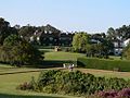 Mount Kenya Safari Club
 -
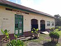 Nanyuki Train Station


.jpg)
See also
References
- ^ "The Tatham Family of County Durham".
- ^ "Major Digby Tatham-Warter".
- ^ "Weatherbase: Historical Weather for Nanyuki, Kenya". Weatherbase. 2011. Retrieved on November 24, 2011.
- ^ "NANYUKI".
- ^ "Nanyuki Town Kenya - A Guide to Nanyuki Kenya". Softkenya.com. 2010-01-11. Retrieved 2017-06-29.
- ^ Emerton, Lucy. "Mount Kenya: The Economics of Community Conservation" (PDF). International Institute for Environment and Development.
- ^ "Mount Kenya Wildlife Conservancy - Magical Kenya". Magical Kenya. Retrieved 2017-06-29.
- ^ "Closer look: Ol Pejeta Conservancy". Fauna and Flora International. Retrieved 16 February 2016.
External links
| International | |
|---|---|
| National | |
| Geographic | |