
Naypyidaw
Naypyidaw
နေပြည်တော် NPT | |
|---|---|
Water Fountain Garden, Ministry Zone, Gems Museum, Union Parliament | |
 Naypyidaw Location of Nay Pyi Taw, Myanmar  Naypyidaw Naypyidaw (Asia) | |
| Coordinates: 19°44′51″N 96°06′54″E / 19.74750°N 96.11500°E | |
| Country | |
| Division | Naypyidaw Union Territory[1] |
| Subdivisions | 8 townships |
| Settled | 2005 |
| Incorporated | 2008 |
| Seat | Nay Pyi Taw City Hall |
| Government | |
| • Body | Naypyidaw Development Committee |
| • Chairman | Myo Aung (Mayor) |
| Area | |
| • Total | 7,054.37 km2 (2,723.71 sq mi) |
| Elevation | 115 m (377 ft) |
| Population | |
| • Total | 924,608 |
| • Density | 131.1/km2 (339.5/sq mi) |
| Time zone | UTC+06:30 (MMT) |
| Area code | 067 |
Naypyidaw, officially
As the seat of the government of Myanmar, Naypyidaw is the site of the
Etymology
Naypyidaw is Burmese for "abode of the king", and is generally translated as "royal capital",[8] "seat of the king", or "abode of kings".[3] Traditionally, it was used as a suffix to the names of royal capitals, such as Mandalay, which was called Yattanarbon Naypyidaw (ရတနာပုံနေပြည်တော်).
History
Naypyidaw was founded on a
On 27 March 2006, more than 12,000 troops marched in the new capital in its first public event: a massive military parade to mark Armed Forces Day, the anniversary of Burma's 1945 revolution against the Japanese occupation. Filming was restricted to the concrete parade ground, which contains enormous sculptures of Kings Anawrahta, Bayinnaung and Alaungpaya. The city was officially named Naypyidaw[13] during these ceremonies,[14] and the official, albeit mostly administrative, capital of the country was relocated from Yangon to Naypyidaw.
On April 4, 2024, the
Rationale behind moving the capital
There are several assumptions why the capital was moved: Naypyidaw is more centrally located than the old capital, Yangon. It is also a transportation hub located adjacent to the Shan, Kayah, and Kayin states. It was felt by governmental and military leaders that a stronger military and governmental presence nearby might provide stability to those chronically turbulent regions.[17] The military's purpose appears to have been to build an impregnable citadel, able to withstand foreign invasion or popular uprisings.[18] The official explanation for moving the capital was that Yangon had become too congested and crowded with little room for future expansion of government offices.[3]
Geography and climate
Naypyidaw is located between the Bago Yoma and Shan Yoma mountain ranges. The city covers an area of 7,054 km2 (2,724 sq mi) and has a population of 924,608, according to official figures.[19]
Chaungmagyi Dam is located a few kilometres to the north of Naypyidaw, while Ngalaik Dam is a few kilometres to the south. The Yezin Dam is farther away in the north-east.
Naypyidaw has a tropical savanna climate (Köppen Climate Classification Aw).
| Climate data for Naypyidaw | |||||||||||||
|---|---|---|---|---|---|---|---|---|---|---|---|---|---|
| Month | Jan | Feb | Mar | Apr | May | Jun | Jul | Aug | Sep | Oct | Nov | Dec | Year |
| Mean daily maximum °C (°F) | 32 (90) |
35 (95) |
38 (100) |
39 (102) |
37 (99) |
34 (93) |
33 (91) |
33 (91) |
34 (93) |
35 (95) |
34 (93) |
32 (90) |
34.5 (94.1) |
| Daily mean °C (°F) | 23 (73) |
25 (77) |
29 (84) |
32 (90) |
31 (88) |
29 (84) |
29 (84) |
28 (82) |
29 (84) |
29 (84) |
27 (81) |
24 (75) |
27.9 (82.2) |
| Mean daily minimum °C (°F) | 16 (61) |
17 (63) |
21 (70) |
25 (77) |
26 (79) |
26 (79) |
25 (77) |
25 (77) |
25 (77) |
24 (75) |
22 (72) |
18 (64) |
22.5 (72.5) |
| Average precipitation mm (inches) | 5 (0.2) |
2 (0.1) |
9 (0.4) |
33 (1.3) |
154 (6.1) |
160 (6.3) |
198 (7.8) |
229 (9.0) |
186 (7.3) |
131 (5.2) |
37 (1.5) |
7 (0.3) |
1,151 (45.5) |
| Average precipitation days | 1 | 0 | 1 | 3 | 14 | 21 | 23 | 24 | 19 | 12 | 4 | 1 | 123 |
| Source: Weather2Travel.com. Retrieved 26 March 2013 | |||||||||||||
Cityscape
Naypyidaw is organized into a number of zones.

Residential zones

The residential areas are carefully organised, and apartments are allotted according to rank and marital status.[20] The city has 1,200 four-story apartment blocks.[21] The roofs of apartment buildings are colour-coded by the jobs of their residents; Ministry of Health employees live in buildings with blue roofs and Ministry of Agriculture employees live in those with green roofs.[20] High-ranking government officials live in mansions,[22] of which there are about 50. However, in 2019, quite a few of the ministerial mansions were reported to be unused and left in a neglected state in overgrown compounds.[23]
Ministry zone
.jpg)
The city's Ministry zone contains the headquarters of Myanmar's government ministries. All the ministry buildings are identical in appearance.
Military zone
High-ranking military officers and other key officials live 11 km (6.8 mi) away from regular government employees in a complex said to consist of tunnels and bunkers; this area is restricted to the public.[20] The city also hosts a military base, which is inaccessible to citizens or other personnel without written permission.[9]
Diplomatic zone
The government has set aside 2 hectares (4.9 acres) of land each for foreign embassies and headquarters of United Nations missions. The Chinese embassy formally opened its interim liaison office in 2017. The liaison office is the first foreign office to be permitted to open in Naypyidaw.[26] Bangladesh and Malaysia have also signed agreements to open embassies in Naypyidaw. The government confirms that proposals have been put forward by 11 other countries to move their embassies to Naypyidaw, namely Russia, China, the United States, India, Saudi Arabia, Qatar, the Philippines, Indonesia, Thailand, Turkey and Kuwait.[27] In February 2018, State Counsellor Daw Aung San Suu Kyi chaired a meeting at the Ministry of Foreign Affairs in Naypyidaw where she urged foreign governments to move their embassies to the capital.

Hotel zone
The Hotel zone has a handful of villa-style hotels on the hilly outskirts of the city. There are twelve hotels located in or near Naypyidaw. Eight of these are located within the Naypyidaw Hotel Zone, and two are located in Laeway (
Shopping

Naypyidaw Myoma Market is the commercial centre of Naypyidaw. Other shopping areas include Thapye Chaung Market , Junction Centre Naypyidaw and Naypyidaw Wholesale. Junction Centre is the city's first privately operated shopping centre.[19] There are also local markets and a restaurant area.
Recreation

Ngalaik Lake Gardens is a small water park situated along the Ngalaik Dam, near Kyweshin Village on Ngalaik Lake (about 11 kilometres (7 mi) from Naypyidaw). Opened in 2008, facilities at the Ngalaik Lake Gardens include water slides, natural resorts, lodging and a beach. The gardens are open to the public during Thingyan holidays.[30]
Also opened in 2008, the 81-hectare (200-acre) National Herbal Park has exhibits of plants having medicinal applications from all of the major regions of Myanmar. There are thousands of plants at the park, representing hundreds of different species.[31] Behind the city hall, there is a park with a playground and water fountain complex, which hosts a musical light show every night.[20]
The Naypyidaw Zoological Gardens opened in 2008 with 420 species and now with 1500 animals. The main attraction of the zoo is the climate-controlled penguin house. The animals were shipped to it from the old one in Yangon.[32][33] The Naypyidaw Safari Park officially opened on 12 February 2011.[34][35]
Naypyidaw also has two golf courses, Naypyidaw City Golf Course and Yaypyar Golf Course, and a gem museum.[28]
Landmark
Administration


The Naypyidaw Union Territory is administered at both the State/Region level, and as a municipality at the local level under two different governing bodies. Naypyidaw is one of three cities in the country to have municipal governance, the others being Yangon and Mandalay.[41]
Naypyidaw Development Committee (NPTDC) is the local government body of the territory. The committee is appointed by the President, and must have at least 5 members, but no more than 9.[44] The Chairperson of the Committee becomes the Mayor of Naypyidaw, the vice-chairman becomes the Vice-Mayor, and the Head of Office becomes the Joint Secretary of the committee.[44] Because both laws make the chair of the Council and Committee the mayor, the same person holds both offices. Matters under the jurisdiction of the Committee include: urban planning, land-use planning, planning permission, traffic management, various public works (sewage treatment, water supply, sanitation, roads, bridges, drainage, etc.), and other local competencies.[44] Unlike the NPTC which must request funding for its budget from the Union government, the committee is permitted to levy taxes to fund its work.[44]
The current mayor is Dr. Maung Maung Naing, appointed as the Chair of Naypyidaw Council on 2 February 2021.[45] Dr. Myo Aung of the National League for Democracy party served as Mayor from his appointment on 1 April 2016, until his arrest on 1 February 2021, during the 2021 Myanmar coup d'état.[46][47]
Administrative divisions
Naypyidaw Union Territory consists of 2
- Ottara District
- Ottarathiri Township (ဥတ္တရသီရိ မြို့နယ်, from Pali uttarasiri)
- Pobbathiri Township (ပုဗ္ဗသီရိ မြို့နယ်, from Pali pupphasiri)
- Tatkone
- )
- Dekkhina District
- Dekkhinathiri Township (ဒက္ခိဏသီရိ မြို့နယ်, from Pali dakkhiṇasiri)
- Lewe Township
- Pyinmana Township
- Zabuthiri Township (ဇမ္ဗူသီရိ မြို့နယ်, from Pali jambusiri)
There is sometimes some controversy about land use and changes in land ownership related to the urban spread of Naypyidaw. In late 2014, for example, there were suggestions in parliament that land grabs were occurring near the Dekkhinathiri Township and that existing laws needed to be amended to provide better protection for farmers.[48] There has also been criticism from some members of parliament about the size of the Naypyidaw Union Territory and the fact that money is being spent on urban infrastructure (such as lighting around lakes) although the facilities do not attract much use.[49]
Transport
Roads

The four-lane, 323.2 km (200.8 mi) Yangon-Naypyidaw highway links Naypyidaw with Yangon directly and is part of the 563 km (350 mi) long

Air
Buses and taxis
Public transport services are limited between neighborhoods.[20] Government ministries run shuttle buses in the morning and evening to their respective buildings.[54]
The city has a central bus station
Railways

Naypyidaw Central railway station was opened at milepost No. (233/0), between Ywataw station and Kyihtaunggan station on the Yangon–Mandalay Railway with a station area of 2,700 m × 1,200 m (9,000 ft × 4,000 ft) and a covered area of 334.5 hectares (826.5 acres). Construction began on 8 December 2006 and Naypyidaw railway station was opened on 5 July 2009, even though the overpass, locomotive shed, concrete road leading up to the station, parking lot, passenger lounge and platform were not completed.[56]
Before the opening of Naypyidaw railway station, Naypyidaw was served by Pyinmana and Lewe stations, though only Pyinmana station is on the main rail line (which extends from Yangon-Bago-Naypyidaw-Thazi-Mandalay). Lewe station is on the way from Pyinmana to Kyaukpadaung. It takes nine hours by train to get from Yangon to Pyinmana; trains leave at 12:00 and arrive at 21:30 local time.[57]
In August 2011, Russian news media announced that a Russian-based firm would be constructing a 50-kilometre (31 mi) metro line, which would be the country's first underground rail system, underneath Naypyidaw.[58][59] However, the Rail Transportation Ministry then announced that the plan had been cancelled due to lack of demand and budgetary limits.[60]
Education and research
Higher education
Yezin(a few kilometers north-east of Naypyidaw and Pyinmana)
- Yezin University of Veterinary Science
- Yezin Agricultural University
- Yezin University of Forestry
- University of Technology [61][62]
- Naypyitaw State Academy
Research
- Forest Research Institute (FRI), Yezin[citation needed]
- Department of Agricultural Research (DAR), Yezin[citation needed]
- Southeast Asia Biodiversity Research Institute (SABRI)[63]
Healthcare

The city is served by five public hospitals: 1000-bed Naypyidaw General Hospital, Naypyidaw Women Hospital, Naypyidaw ENT Hospital, 100-bed Naypyidaw Traditional Medicine Hospital, and Naypyidaw Orthopaedic Hospital.[64][65][66][67][self-published source?] There is also a 300-bed Obstetric, Gynaecological and Children's Hospital of Defence Services, which is one of the teaching hospitals of Myanmar Defence Services Medical Academy. The nearby towns of Lewe, Pyinmana, and Tatkone each have one hospital.[28]
Sports
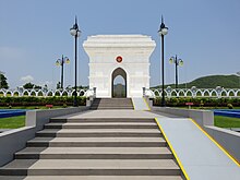
Main sights
Religious sites
Museums and memorials
- Memorial to the Fallen Heroes
- National Museum
- Defence Services Museum
- Naypyidaw Gems Museum
- Planetarium
- The Museum of Sport[68]
Memorial to the Fallen Heroes

Recreation

- Naypyidaw Safari Park
- National Herbal Park
- Naypyidaw Zoological Gardens
- Naypyidaw Water Fountain Garden
- National Landmark Garden
- Naypyidaw Hot Spring Resort
- Wunna Theikdi Stadium
- Wunna Theikdi Indoor Stadium
- Zayarthiri Stadium
Concert halls and theatres
- Myanmar International Convention Centre 1 (MICC-1)
- Myanmar International Convention Centre 2 (MICC-2)
- Open-Air Theatre[69]
Arts and entertainment
The
Media and communications
The headquarters of the Ministry of Information is located in Naypyidaw. Since 2009, Naypyidaw has had mobile phone coverage.
The
Radio
There are a number of AM and FM stations broadcasting in Naypyidaw. The main available channels in Naypyidaw are Myanmar Radio (operated by MRTV), Cherry FM, Mandalay FM, FM Bagan, Padamyar FM, Pyinsawaddy FM, Shwe FM and City FM.
Television
MRTV, MRTV-4 and MWD are the main channels, broadcasting Burmese-language programmes in Naypyidaw. Privately owned enterprise Sky Net provides more than 70 pay-TV channels of local and international origin. MRTV broadcasts 19 free-to-air channels and MWD broadcasts 8 free-to-air channels. Other TV channels such as Channel 7, 5-plus and Myanmar International, the English-language channel that targets overseas audiences are also available.
Costs and issues
One estimate puts the cost in the range of $3–4 billion
There is now continual travel by vehicles along the 300 km (190 mi) highway from Yangon to Naypyidaw, which is four lanes for most of the way. There are relatively few vehicles for much of the time on the road. Most trucks traveling north from Yangon to Naypyidaw and Mandalay are prohibited from using the highway. The Asian Development Bank has estimated that allowing more trucks onto the road would save over $100 million per year in reduced traveling time and other savings.[72] There are plans to turn the road into a six-lane highway for greater safety.[73]
The proportion of housing that meets expatriate needs is limited because the majority of existing apartments are for government employees.[74]
In popular culture
In March 2014, Naypyidaw was one of the locations featured on the British motoring TV show Top Gear during a two-part special event in Myanmar.
In 2018, Naypyidaw was on the TV show Dark Tourist.
See also
Gallery
-
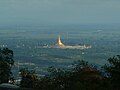 Uppatasanti Pagoda (western view)
 -
 Uppatasanti Pagoda at sunset
 -
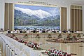 Government reception
 -

-

-
 Planetarium
 -
 Thatta Thattaha Maha Bawdi Pagoda
 -
 Maha Thakya Yan Thi Pagoda
 -
 Naypyidaw Gems Museum
 -
 Naypyidaw hosting the2013 Southeast Asian Games
 -
 Union Parliament (Interior View)
 -
 A press conference in Naypyidaw
 -
 A ceremonial reception in Naypyidaw


.jpg)
.jpg)
References
- Dulyapak Preecharushh, Naypyidaw: New Capital of Burma, 2009, White Lotus. ISBN 978-9744801302
Notes
- ^ a b "Eleven Media Group Co., Ltd" တိုင်းခုနစ်တိုင်းကို တိုင်းဒေသကြီးများအဖြစ် လည်းကောင်း၊ ကိုယ်ပိုင်အုပ်ချုပ်ခွင့်ရ တိုင်းနှင့် ကိုယ်ပိုင်အုပ်ချုပ်ခွင့်ရ ဒေသများ ရုံးစိုက်ရာ မြို့များကို လည်းကောင်း ပြည်ထောင်စုနယ်မြေတွင် ခရိုင်နှင့်မြို့နယ်များကို လည်းကောင်း သတ်မှတ်ကြေညာ. Weekly Eleven News (in Burmese). 20 August 2010. Archived from the original on 11 November 2014. Retrieved 23 August 2010.
- ^ "News Briefs". The Myanmar Times. Myanmar Consolidated Media. 20 March 2006. Archived from the original on 27 June 2006. Retrieved 1 April 2006.
- ^ a b c d Pedrosa, Veronica (20 November 2006). "Burma's 'seat of the kings'". Al Jazeera. Archived from the original on 23 November 2006. Retrieved 21 November 2006.
- ^ Department of Population, Myanmar.
- ^ Dulyapak Preecharushh. "Myanmar's New Capital City of Naypyidaw". Engineering Earth. Academia.edu: 1021–1044. Archived from the original on 1 June 2022. Retrieved 20 October 2020.
- ^ "This 'empty' city is more than four times the size of London". indy100. 21 June 2017. Archived from the original on 10 November 2017. Retrieved 21 June 2017.
- ^ "Inside Burma's ghost town capital city, which is 4 times the size of London with a fraction of the population". The Independent. 23 June 2017. Archived from the original on 18 June 2022. Retrieved 1 October 2021.
- ^ "An Introduction to the Toponymy of Burma (October 2007) – Annex A" Archived 31 October 2008 at the Wayback Machine p. 8, The Permanent Committee on Geographic Names (PCGN), United Kingdom
- ^ a b Marshall Cavendish Corporation (2007). World and Its Peoples: Eastern and Southern Asia. Marshall Cavendish. p. 650.
- ^ "Buki Yuushuu". YouTube. Archived from the original on 24 July 2018. Retrieved 28 June 2017.
- ^ "The lights are on but no one's home in Myanmar's capital Naypyidaw". 4 April 2015.
- ^ "Burma's bizarre capital: A super-sized slice of post-apocalypse suburbia | Cities | the Guardian". Archived from the original on 20 October 2022. Retrieved 20 October 2022.
- ^ "Naypyidaw: Burma". Geographical Names. Archived from the original on 5 May 2013. Retrieved 6 December 2011.
- ^ "Burma's new capital stages parade". BBC News. 27 March 2006. Archived from the original on 3 December 2018. Retrieved 6 April 2006.
- BBC. 4 April 2024.
- ^ "Myanmar Resistance Drones Target Junta Chief's Residence, Military HQ and Airbase in Naypyitaw". The Irrawaddy. 4 April 2024.
- ^ McGeown, Kate (8 November 2005). Burma's confusing capital move Archived 6 January 2009 at the Wayback Machine. BBC News.
- ^ "Myanmar civil war: 'We wish we could go back'". BBC News. 16 April 2023. Archived from the original on 17 April 2023. Retrieved 17 April 2023.
- ^ Xinhua News. 24 December 2009. Archivedfrom the original on 15 October 2012. Retrieved 25 December 2009.
- ^ a b c d e f g Living in a ghost town. Bangkok Post. 18 October 2009.
- ^ Peck, Grant (5 October 2007). "Myanmar's Remote Capital Is Still a Work in Progress". The New York Times. Archived from the original on 16 January 2018. Retrieved 20 May 2010.
- ^ [1][dead link]
- ^ Handa and Ye Mon, 'Official residences in Nya Pyi Daw left to ruin' Archived 21 December 2019 at the Wayback Machine, Frontier Myanmar, 20 December 2019.
- ^ The Australian. "A monument to junta's fear Archived 8 May 2013 at the Wayback Machine". 16 October 2007
- ^ "As poll looms, Myanmar still building parliament". Reuters. 17 January 2010. Archived from the original on 22 October 2021. Retrieved 1 July 2017.
- ^ "China embassy opens interim liaison office in Naypyidaw". The Myanmar Times. Archived from the original on 28 May 2018. Retrieved 27 May 2018.
- ^ Mon, Su Myat. "Govt urges Naypyidaw move for embassies, but obstacles remain". Frontier Myanmar. Archived from the original on 28 May 2018. Retrieved 27 May 2018.
- ^ a b c d "Myanmar Yellow Pages: Naypyidaw Listings". Archived from the original on 2 March 2012.
- ^ "New hotels rise in Naypyidaw ahead of SEA Games". Weekly Eleven. 10 October 2012. Archived from the original on 13 November 2012. Retrieved 22 October 2012.
- ^ "Briefing on construction of Naypyidaw Ngalaik Lake Gardens". Archived from the original on 2 March 2012.
- ^ "National herbal Park". tours in Myanmar. toursinmyanmar. 2010. Archived from the original on 28 May 2018. Retrieved 13 May 2017.
- ^ a b "Built to Order: Myanmar's New Capital Isolates and Insulates Junta". The New York Times. 24 June 2008. Archived from the original on 4 November 2020. Retrieved 22 February 2017.
- ^ "Myanmar unveils zoo in remote new capital | MACAU DAILY TIMES". Macau Daily Times. 27 March 2008. Archived from the original on 28 September 2018. Retrieved 27 September 2018.
- ^ "Safari Park (Naypyidaw) to open on 12 February". Bi-Weekly Eleven. 26 January 2011. Archived from the original on 30 April 2011.
- ^ [2] Archived 14 September 2011 at the Wayback Machine
- ^ "Than Shwe offers golden lotus to Uppatasanti". Archived from the original on 25 February 2012.
- ^ Uppatasanti Pagoda, replica of Shwedagon Pagoda in Nay Pyi Daw Archived 27 April 2011 at the Wayback Machine
- ISBN 978-0-19-539068-1.
- ^ "Naypyidaw's Version of Shwedagon Pagoda Nears Completion". Archived from the original on 11 August 2010.
- ^ Weekly Eleven News Journal, Vol. 1, No. 44 (16 August 2006), p. 9.
- ^ a b "MUNICIPAL GOVERNANCE IN MYANMAR: AN OVERVIEW OF DEVELOPMENT AFFAIRS ORGANIZATIONS" (PDF). The Asia Foundation. Archived (PDF) from the original on 3 December 2021. Retrieved 23 November 2021.
- ^ a b c "The Nay Pyi Taw Council Law (The State Peace and Development Council Law No. 18 /2010 ) The 13th Waxing of Thadinkyut, 1372 M.E. (21st October, 2010)" (PDF). Myanmar Information Management Unit (MIMU). United Nations Development Programme. Archived (PDF) from the original on 23 November 2021. Retrieved 23 November 2021.
- ^ "Archived copy" (PDF). upload.wikimedia.org. Archived from the original (PDF) on 27 April 2011. Retrieved 15 January 2022.
{{cite web}}: CS1 maint: archived copy as title (link) - ^ a b c d "The Nay Pyi Taw Development Law ( The State Peace and Development Council Law No. 4 / 2009) The 14th Waxing of Pyatho, 1371, M.E.(29 December, 2009)" (PDF). Online Burma/Myanmar Library. Burma Peace Foundation. Archived (PDF) from the original on 9 March 2022. Retrieved 23 November 2021.
- ^ "Republic of the Union of Myanmar, State Administration Council Order No (12/2021), 6th Waning of Pyatho 1382 ME, 2 February 2021, Appointment and Assignment of Chairman of Nay Pyi Taw Council". mitv. Myanmar International Television. Archived from the original on 23 November 2021. Retrieved 23 November 2021.
- ^ Swan Ye Htut (5 April 2016). "New Nay Pyi Taw Council chair meets staff". The Myanmar Times. Thein Tun. Archived from the original on 23 November 2021. Retrieved 23 November 2021.
- ^ "Closing argument for section 505 (b) charge against President, State Counselor, Nay Pyi Taw Council chair in next trial". News Eleven. Eleven Media Group Co, Ltd. 3 November 2021. Archived from the original on 23 November 2021. Retrieved 23 November 2021.
- ^ 'Call for amending Naypyitaw Development Law' Archived 3 March 2016 at the Wayback Machine, The Nation, 12 December 2014.
- ^ 'Naypyidaw Union Territory Should Be Shrunk, Says MP' Archived 13 February 2015 at the Wayback Machine, Eleven, 11 February 2015.
- ^ Tun, Aung Hla (16 January 2010). "As poll looms, Myanmar still building parliament". Reuters. Archived from the original on 22 October 2021. Retrieved 1 July 2017.
- ^ from the original on 17 June 2017. Retrieved 2 October 2021.
- ^ "News Briefs (New air destinations)". The Myanmar Times. Myanmar Consolidated Media. 12 June 2006. Archived from the original on 20 February 2012. Retrieved 29 June 2006.
- ^ "Myanmar opens international airport in new capital". Reuters. 19 December 2011. Archived from the original on 28 May 2018. Retrieved 27 May 2018.
- ^ Varadarajan, Siddharth (21 January 2007). In phantom capital, a city slowly takes shape. The Hindu.
- ^ Win Ko Ko Latt (21 March 2011). "Motorbike ban to be expanded in NPT". Myanmar Times. Archived from the original on 16 July 2011. Retrieved 18 August 2011.
- ^ "New railway station reflects dignity of Naypyidaw" (PDF). The New Light of Myanmar. Ministry of Information. 24 November 2009. Archived from the original (PDF) on 27 April 2011. Retrieved 22 July 2010.
- ^ "Import, export licensing moving to Naypyidaw". The Myanmar Times. Myanmar Consolidated Media. 29 May 2006. Archived from the original on 20 February 2012. Retrieved 29 June 2006.
- ^ Nikishenkov, Oleg (5 August 2011). "Moscow exports the metro – to Myanmar". Moscow Times. Russia & India Report. Archived from the original on 15 March 2012. Retrieved 8 August 2011.
- ^ Wade, Francis (2 August 2011). "Russia to build metro in Naypyidaw: reports". Democratic Voice of Burma. Archived from the original on 23 February 2015. Retrieved 8 August 2011.
- ^ Sann Oo (5 September 2011). "Subway plan for Naypyidaw too expensive, says minister". Myanmar Times. Archived from the original on 4 February 2012. Retrieved 3 March 2012.
- ^ "အစိုးရနည်းပညာကောလိပ် (နေပြည်တော်) · P399+75Q, Myinttar Street, Naypyidaw, Myanmar (Burma)".
- ^ "Myanmar to open new university from academic year 2022-2023". Archived from the original on 25 January 2023. Retrieved 25 January 2023.
- ^ "China-Myanmar Established Biodiversity Research Institute Unveiled in Naypyidaw—Chinese Academy of Sciences". english.cas.cn. 13 October 2016. Archived from the original on 20 October 2017. Retrieved 19 October 2017.
- ^ "EYE.ENT Hospital Naypyitaw". EyeMyanmar. 9 March 2016. Retrieved 12 October 2017.
- ^ "Naypyidaw Hospital looks to boost hygiene, reception services". The Myanmar Times. Archived from the original on 12 October 2017. Retrieved 12 October 2017.
- ^ "Orthopaedic Specialist Hospital opens in Naypyidaw – Global New Light Of Myanmar". Global New Light Of Myanmar. 21 July 2015. Archived from the original on 12 October 2017. Retrieved 12 October 2017.
{{cite news}}: CS1 maint: unfit URL (link) - ISBN 9781312884472.
- ^ "The Museum of Sport in Naypyidaw is exhibiting more than 300 medals won by the nation's athletes". Archived from the original on 14 October 2017. Retrieved 13 October 2017.
- ^ "Venues & Rates". travelnaypyitaw.org. Archived from the original on 26 September 2017. Retrieved 19 October 2017.
- ^ "Naypyidaw's Oscar Event". The Irrawaddy. IPG. 12 February 2008. Archived from the original on 19 August 2014.
- ^ "Information Ministry launches 'Naypyitaw Times Journal'". 7 March 2012. Archived from the original on 7 March 2012. Retrieved 28 May 2018.
- ^ Thomas Manch and Kyaw Lin Htoon, 'The road rules costing Myanmar billions' Archived 10 April 2022 at the Wayback Machine, Frontier Myanmar, 14 December 2017.
- ^ Construction on some sections of a six-lane highway are already underway (mid-2014) along the highway. Parts of the highway have already been widened to six lanes, and a number of bridges along the road are in the construction stage of being widened. For a discussion of safety concerns about the national highways to Naypyidaw, see the report about plans to improve the highway linking Naypyidaw and Mandalay at Kyaw Hsu Mon, 'Govt Calls for Foreign Investment in 'Death Highway' Upgrade' Archived 16 October 2015 at the Wayback Machine, The Irrawaddy, 29 December 2014.
- ^ Kyaw Soe Htet, 'More time needed before expatriates consider relocating to Nay Pti Daw' Archived 10 April 2022 at the Wayback Machine, Myanmar Times, 8 October 2019.
External links
- Nay Pyi Daw – A photo album
- Inside Napyidaw, The Flying Dutchman blog, 15 June 2007 (one of first two tourists to visit Naypyidaw, includes many photos)
- Abode of Kings in a Derelict Kingdom, Disposable Words blog, 15 June 2007 (second of first two tourists to visit Naypyidaw, more photos)
- BBC Top Gear Series 21 Episode 6
| International | |
|---|---|
| National | |
| Other | |