
New Amsterdam
This article needs additional citations for verification. (January 2022) |
New Amsterdam
Nieuw Amsterdam ( Dutch settlement | |
|---|---|
 View of New Amsterdam | |
|
UTC–04:00 (EDT ) |
New Amsterdam (
| New Netherland series |
|---|
| Exploration |
| Fortifications: |
|
| Settlements: |
|
| The Patroon System |
|
| People of New Netherland |
| Flushing Remonstrance |
 |
| History of New York City |
|---|
|
Lenape and New Netherland, to 1664 New Amsterdam British and Revolution, 1665–1783 Federal and early American, 1784–1854 Tammany and Consolidation, 1855–1897 (Civil War, 1861–1865) Early 20th century, 1898–1945 Post–World War II, 1946–1977 Modern and post-9/11, 1978–present |
| See also |
|
Transportation Timelines: NYC • Bronx • Brooklyn • Queens • Staten Island Category |
By 1655, the population of New Netherland had grown to 2,000 people, with 1,500 living in New Amsterdam. By 1664, the population of New Netherland had risen to almost 9,000 people, 2,500 of whom lived in New Amsterdam, 1,000 lived near Fort Orange, and the remainder in other towns and villages.[2][4]
In 1664, the English took over New Amsterdam and renamed it
Etymology
The indigenous Munsee term for the southern tip of the island was Manhattoe, and variations of this name were also applied to the first Dutch settlement there. With the construction of Fort Amsterdam, the town also became variously known as "Amsterdam" or "New Amsterdam". New Amsterdam's city limits did not extend north of the wall of Wall Street, and neither the remainder of the island of Manhattan nor of wider New Netherland fell under its definition.
History
Early exploration and settlement (1609–1624)

In 1524, nearly a century before the arrival of the Dutch, the site that would later become New Amsterdam was named
At the time, beaver pelts were highly prized in Europe, because the fur could be felted to make waterproof hats. A by-product of the trade in beaver pelts was castoreum—the secretion of the animals' anal glands—which was used for its medicinal properties and for perfumes. The expeditions by Adriaen Block and Hendrick Christiaensen in 1611, 1612, 1613 and 1614, resulted in the surveying and charting of the region from the 38th parallel to the 45th parallel.[7] On their 1614 map, which gave them a four-year trade monopoly under a patent of the States General, they named the newly discovered and mapped territory New Netherland for the first time. It also showed the first year-round trading presence in New Netherland, Fort Nassau, which would be replaced in 1624 by Fort Orange, which eventually grew into the town of Beverwijck, renamed Albany in 1664.
Spanish trader
The territory of New Netherland was originally a private, profit-making commercial enterprise focused on cementing alliances and conducting trade with the local Indigenous peoples. Surveying and exploration of the region was conducted as a prelude to an anticipated official settlement by the Dutch Republic, which occurred in 1624.
Pilgrims' attempt to settle in the Hudson River area

In 1620 the Pilgrims attempted to sail to the Hudson River from England. However, Mayflower reached Cape Cod (now part of Massachusetts) on November 9, 1620, after a voyage of 64 days.[10] For a variety of reasons, primarily a shortage of supplies, Mayflower could not proceed to the Hudson River, and the colonists decided to settle near Cape Cod, establishing the Plymouth Colony.
Dutch return
The mouth of the Hudson River was selected as the ideal place for initial settlement as it had easy access to the ocean while also securing an ice-free lifeline to the beaver trading post near present-day Albany. Here, Indigenous hunters supplied them with pelts in exchange for European-made trade goods and wampum, which was soon being made by the Dutch on Long Island. In 1621, the Dutch West India Company was founded. Between 1621 and 1623, orders were given to the private, commercial traders to vacate the territory, thus opening up the territory to Dutch settlers and company traders. It also allowed the laws and ordinances of the states of Holland to apply. Previously, during the private, commercial period, only the law of the ship had applied.
In May 1624, the first settlers in New Netherland arrived on Noten Eylandt (Nut or Nutten Island, now Governors Island) aboard the ship Nieu Nederlandt under the command of Cornelius Jacobsen May, who disembarked on the island with thirty families to take legal possession of the New Netherland territory.[11][12] The WIC ordered engineer and surveyor Crijn Fredericxsz for the construction of Fort Amsterdam.[13] A fortification was completed in 1626.[13]
The families were then dispersed to Fort Wilhelmus on Verhulsten Island (Burlington Island) in the South River (now the Delaware River), to Kievitshoek (now Old Saybrook, Connecticut) at the mouth of the Verse River (now the Connecticut River) and further north at Fort Nassau on the Mauritius or North River (now the Hudson River), near what is now Albany.
A fort and sawmill were soon erected at Nut Island. The windmill was constructed by Franchoys Fezard and was taken apart for iron in 1648.
Fort Amsterdam (1624)


The threat of attack from other European colonial powers prompted the directors of the Dutch West India Company to formulate a plan to protect the entrance to the Hudson River. In 1624, 30 families were sponsored by Dutch West India Company moving from Nut Island to Manhattan Island, where a citadel to contain Fort Amsterdam was being laid out by Cryn Frederickz van Lobbrecht at the direction of Willem Verhulst. By the end of 1625, the site had been staked out directly south of Bowling Green on the site of the present U.S. Custom House. The Mohawk-Mahican War in the Hudson Valley led the company to relocate even more settlers to the vicinity of the new Fort Amsterdam. In the end, colonizing was a prohibitively expensive undertaking, only partly subsidized by the fur trade. This led to a scaling back of the original plans. By 1628, a smaller fort was constructed with walls containing a mixture of clay and sand.
The fort also served as the center of trading activity. It contained a barracks, the church, a house for the West India Company director and a warehouse for the storage of company goods.[14] Troops from the fort used the triangle between the Heerestraat and what came to be known as Whitehall Street for marching drills.
1624–1664
_Drawing_1650-1654.jpg)


Verhulst, with his council, was responsible for the selection of Manhattan as a permanent place of settlement and for situating Fort Amsterdam. He was replaced as the company director of New Netherland by
An official letter of November 7, 1626 in which Pieter Schagen informed the
The Dutch introduced
The New Amsterdam settlement had a population of approximately 270 people, including infants.[22] In 1642 the new director Willem Kieft decided to build a stone church within the fort. The work was carried out by recent English immigrants, the brothers John and Richard Ogden. The church was finished in 1645 and stood until destroyed in the Slave Insurrection of 1741.
A pen-and-ink view of New Amsterdam,[23][24] drawn on-the-spot and discovered in the map collection of the Austrian National Library in Vienna in 1991, provides a unique view of New Amsterdam as it appeared from Capske (small Cape) Rock in 1648. It was associated with Adriaen van der Donck's Remonstrance of New Netherland, and may have inspired later views as by Claes Jansz. Visscher. Capske Rock was situated in the water close to Manhattan between Manhattan and Noten Eylant, and signified the start of the East River roadstead.
New Amsterdam received municipal rights by a charter from New Netherland Governor Peter Stuyvesant on February 2, 1653, thus becoming a city.[3]
Albany, then named Beverwyck, received its city rights in 1652. Nieuw Haarlem, now known as Harlem, was formally recognized in 1658.
The first
On September 15, 1655, New Amsterdam was occupied by several hundred Munsee, possibly in response to a Dutch colonist killing a woman stealing peaches from his orchard. No bloodshed occurred until the Munsee were fired upon as they were preparing to depart. This triggered attacks on Pavonia and Staten Island. Stuyvesant reported 28 farms destroyed, 40 deaths and 100 captives taken in what later became known as the Peach War.[29]
In 1661, the
In 1664, Jan van Bonnel built a
-
 Novum Amsterodamum 1650, by Laurens Block
 -
 New Amsterdam in 1660, Scale Model
 -
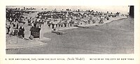 New Amsterdam from the East River in 1660, Scale Model
 -
 Party For New Year's Day In New Amsterdam 1636 (George Boughton)
 -
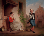 Courtship in New Amsterdam (Fancis W. Edmonds)
_painting_by_Laurens_Block.jpg)

_Museum_of_NYC.jpg)


English capture
On August 27, 1664, while England and the Dutch Republic were at peace, four English frigates sailed into New Amsterdam's harbor and demanded New Netherland's surrender, effecting the bloodless
In 1667, the Treaty of Breda ended the conflict in favor of the Dutch. The Dutch did not press their claims on New Netherland but did demand control over the valuable sugar plantations and factories captured by them that year on the coast of Surinam, giving them full control over the coast of what is now Guyana and Suriname.
On 9 August 1673 (N.S.; 30 July 1673 (O.S.)), during the Third Anglo-Dutch War, the Dutch quickly but briefly retook the colony of New Netherland, which the English called "New York", with a combined fleet of a squadron of ships from Amsterdam and a squadron of ships from Zeeland. The commanders were Jacob Benckes (Koudum, 1637–1677) and Cornelis Evertsen de Jongste (Vlissingen, 1642–1706) under instruction of the States General of the Dutch Republic.[35] Anthony Colve was installed as the first Dutch governor of the province. Previously there had only been West India Company Directors and a Director-General.
Amidst the recapture, New York City would be again renamed, this time to New Orange.[36] However, after the signing of the Treaty of Westminster in February 1674, both the Dutch territories were relinquished to the English. With the effective transfer of control on 10 November 1674 (N.S.), the names New Netherland and New Orange reverted to the English versions of "New York" and "New York City", respectively. Suriname became an official Dutch possession in return.
-
 The Dutch surrender New Amsterdam in 1664
 -

-
 City of New Orange in 1673
_1664_by_Ogden.jpg)
.png)
_1673_sketched.png)
Cartography

The beginnings of New Amsterdam, unlike most other colonies in the New World, were thoroughly documented in city maps. During the time of New Netherland's colonization, the Dutch were the pre-eminent cartographers in Europe. The delegated authority of the Dutch West India Company over New Netherland required maintaining sovereignty on behalf of the States General, generating cash flow through commercial enterprise for its shareholders, and funding the province's growth. Thus its directors regularly required that censuses be taken. These tools to measure and monitor the province's progress were accompanied by accurate maps and plans. These surveys, as well as grassroots activities to seek redress of grievances,[24] account for the existence of some of the most important of the early documents.[37]
There is a particularly detailed city map called the Castello Plan produced in 1660. Virtually every structure in New Amsterdam at the time is believed to be represented, and by cross-referencing the Nicasius de Sille List of 1660, which enumerates all the citizens of New Amsterdam and their addresses, it can be determined who resided in every house.[38]
The city map known as the Duke's Plan probably derived from the same 1660 census as the Castello Plan. The Duke's Plan includes two outlying areas of development on Manhattan along the top of the plan. The work was created for James (1633–1701), the Duke of York and Albany, after whom New York, New York City, and New York's Capital – Albany, were named just after the seizure of New Amsterdam by the English.[39] After that provisional relinquishment of New Netherland, Stuyvesant reported to his superiors that he "had endeavored to promote the increase of population, agriculture and commerce...the flourishing condition which might have been more flourishing if the now afflicted inhabitants had been protected by a suitable garrison...and had been helped with the long sought for settlement of the boundary, or in default thereof had they been seconded with the oft besought reinforcement of men and ships against the continual troubles, threats, encroachments and invasions of the British neighbors and government of Hartford Colony, our too powerful enemies".
The existence of these city maps has proven to be very useful in the archaeology of New York City. For instance, the Castello map aided the excavation of the
Layout
The maps enable a precise reconstruction of the town. Fort Amsterdam was located at the southernmost tip of the island of Manhattan, which today is surrounded by Bowling Green. The Battery is a reference to its battery of cannon.
Broadway was the main street that led out of town north towards Harlem. The town was surrounded to the north by a wall leading from the eastern to the western shore. Today, where the course of this city wall was, is Wall Street. Nearby, a canal which led from the harbor inland was filled in 1676, and is today Broad Street.
The layout of the streets was winding, as in a European city. Only starting from Wall Street going toward uptown did the typical grid become enforced long after the town ceased to be Dutch. Most of the Financial District overlaps with New Amsterdam and has retained its original street layout.
Legacy

The 1625 date of the founding of New Amsterdam is now commemorated in the official Seal of New York City. (Formerly, the year on the seal was 1664, the year of the provisional Articles of Transfer, assuring New Netherlanders that they "shall keep and enjoy the liberty of their consciences in religion", negotiated with the English by Peter Stuyvesant and his council.)
Sometimes considered a dysfunctional trading post by the English who later acquired it from the Dutch, Russell Shorto, author of The Island at the Center of the World, suggests that the city left its cultural marks on later New York and, by extension, the United States as a whole.[42]
Major recent historical research has been based on a set of documents that have survived from that period, untranslated. They are the administrative records of the colony, unreadable by most scholars. Since the 1970s, Charles Gehring of the New Netherland Institute has made it his life's work to translate this first-hand history of the Colony of New Netherland.[43]
The scholarly conclusion has largely been that the settlement of New Amsterdam is much more like current New York than previously thought. Cultural diversity and a mindset that resembles the American Dream were already present in the first few years of this colony. Writers like Russell Shorto argue that the large influence of New Amsterdam on the American psyche has largely been overlooked in the classic telling of American beginnings, because of animosity between the English victors and the conquered Dutch.
The original 17th-century architecture of New Amsterdam has completely vanished (affected by the fires of 1776 and 1835),[44][45] leaving only archaeological remnants. The original street plan of New Amsterdam has stayed largely intact, as have some houses outside Manhattan.
The presentation of the legacy of the unique culture of 17th-century New Amsterdam remains a concern of preservationists and educators. In 2009 the National Park Service celebrated the 400th anniversary of Henry Hudson's 1609 voyage on behalf of the Dutch with the New Amsterdam Trail.[46][47]
The
A similar theme, at greater length, was taken up by writer
One of New York's Broadway theatres is the New Amsterdam Theatre. The name New Amsterdam is also written on the architrave situated on top of the row of columns in front of the Manhattan Municipal Building, commemorating the name of the Dutch colony.
Although no architectural monuments or buildings have survived, the legacy lived on in the form of Dutch Colonial Revival architecture. A number of structures in New York City were constructed in the 19th and 20th centuries in this style, such as Wallabout Market in Brooklyn, South William Street in Manhattan, West End Collegiate Church at West 77th Street, and others.
-
 The Wyckoff Farm in Flatbush, Brooklyn. Some of its construction still dates from the Dutch period of what is currently New York City.
 -
 13–15 South William Street, constructed in the Dutch Colonial Revival architecture evoking New Amsterdam

_Manhattan_NYC.jpg)
See also
Notes
- ^ "ArcGIS REST Services Directory". United States Census Bureau. Retrieved September 20, 2022.
- ^ a b "The Colony of New Netherland", 2009, by Jaap Jacobs, page 32.
- ^ a b "The New York Tercentenary: An Exhibition of the History of New Netherland", in by Victor Hugo Paltsits, in Bulletin of the New York Public Library (October, 1926) p.780
- ^ Park, Kingston Ubarn Cultural. "Dutch Colonization". nps.gov.
- ^ Rankin, Rebecca B., Cleveland Rodgers (1948). New York: the World's Capital City, Its Development and Contributions to Progress. Harper.
{{cite book}}: CS1 maint: multiple names: authors list (link) - ^ Nieuwe Wereldt ofte Beschrijvinghe van West-Indian, uit veelerhande Schriften ende Aen-teekeningen van verscheyden Natien (Leiden, Bonaventure & Abraham Elseviers, 1625) p.83: "/in den jare 1609 sonden de bewindt-hebbers van de gheoctroyeerde Oost-Indischische compagnie het jacht de halve mane/ daer voor schipper ende koopman op roer Hendrick Hudson[...]"("in the year 1609 the administrators of the East Indies Company sent the half moon captained by the merchant Hudson[...]")
- ^ Bancroft, George (October 24, 1886). History of the United States of America: From the Discovery of the Continent. D. Appleton. p. 489 – via Internet Archive.
- ^ Juan Rodriguez monograph. Ccny.cuny.edu. Retrieved 23 July 2013.
- ^ Honoring Juan Rodriguez, a Settler of New York – NYTimes.com. Cityroom.blogs.nytimes.com. Retrieved 23 July 2013.
- ISBN 0-916489-13-2. (page 20).
- ^ Mixit Productions. "The New Amsterdam Trail – A Virtual Tour". nyharborparks.org. Retrieved June 26, 2015.
- ^ ""Battery Park". New York City Department of Parks & Recreation. Retrieved on September 13, 2008". Nycgovparks.org. Archived from the original on May 4, 2009. Retrieved October 4, 2010.
- ^ a b "Amsterdam, fort (New York)". Atlas of Mutual Heritage. December 1, 2022. Archived from the original on February 8, 2023.
- ^ ""The New Amsterdam Trail", National Parks of New York Harbor Conservancy" (PDF). Archived from the original (PDF) on December 4, 2011.
- ^ Benchley, Nathaniel. "The $24 Swindle: The Native Americans who sold Manhattan were bilked, all right, but they didn't mind – the land wasn't theirs anyway." American Heritage, Vol. 11, no. 1 (Dec. 1959).
- ^ Schagenbrief
- ^ Transcriptie Schagenbrief
- ^ According to a calculation by the International Institute of Social History, Amsterdam at International Institute of Social History, Amsterdam, Netherlands
- ISBN 9780199741205. Retrieved January 23, 2023 – via Google Books.
- ISBN 978-0822389811. Retrieved April 14, 2013.
- ISBN 9780471297147. Retrieved April 14, 2013.
- ^ "A Brief Outline of the History of New Netherland". Coin and Currency Collections in the Department of Special Collections University of Notre Dame Libraries. Archived from the original on July 8, 2023. Retrieved July 12, 2018.
- ^ "New York, um 1650". Österreichische Nationalbibliothek. Retrieved May 7, 2023.
- ^ a b de Koning, Joep M.J. (July–August 2000). "From Van der Donck to Visscher" (PDF). Mercator's World. Retrieved February 19, 2013.
- ^ Hertzberg, Arthur (1997). The Jews in America. New York: Columbia University Press. p. 9.
- ^ Hertzberg, Arthur (1997). The Jews in America. New York: Columbia University Press. pp. 7–8.
- ^ Hertzberg, Arthur (1997). The Jews in America. New York: Columbia University Press. pp. 10–11.
- ^ Hertzberg, Arthur (1997). The Jews in America. New York: Columbia University Press. p. 17.
- ^ Trelease, Allan W. (1960). Indian Affairs in Colonial New York: The Seventeenth Century. Ithaca, New York: Cornell University Press.
- ^ Railroad Ferries of the Hudson: And Stories of a Deckhand, by, Raymond J. Baxter, Arthur G. Adams, pg. 46 ,1999, Fordham University Press, 978-0823219544
- ^ a b "The saw-kill and the making of Dutch colonial Manhattan: Sawkill Lumber Co". Sawkil.com. Archived from the original on March 3, 2022. Retrieved April 14, 2013.
- ^ Arthur Bunyan Caldwell (1882). The History of Harlem: An Historical Narrative Delivered at Harlem Music Hall, April 24th, 1882: a Lecture. Small Talk Publishing Company. p. 21. Retrieved April 14, 2013.
74th street Saw Mill.
- ISBN 9781450019408. Retrieved April 14, 2013.
- ^ Henry L. Schoolcraft, "The Capture of New Amsterdam", English Historical Review (1907) 22#88 674–693 in JSTOR
- ISBN 9789462492745.
- ^ "When New York was officially named New Orange". March 7, 2011.
- ^ Robert Augustyn, "Maps in the making of Manhattan" Magazine Antiques, September 1995. Retrieved December 15, 2005.
- ^ Several reproductions of the Castello plan can be found on-line: New Netherland Project Archived July 8, 2009, at the Wayback Machine, New York Public Library, Wikimedia Commons. Colored versions from 1916 can be found here: New York University and here:New York Historical Society. A "Digital redraft of the Castello Plan of New Amsterdam in New Netherland in 1660" is an interactive map that can be found on ekamper.net Archived June 2, 2019, at the Wayback Machine. This map allows you to click in various places to learn more about the ownership and use of the land and buildings. All URLs accessed on February 17, 2010. A Google Earth File of the Castello Plan is posted on bbs.keyhole.com Archived July 7, 2012, at archive.today.
- ^ An image of the Duke's map can be found on-line at the British Library site: THE BRITISH LIBRARY URL accessed on December 15, 2005.
- ^ A slideshow of the famous Stadt Huys dig, a landmark archaeological excavation of one of the central blocks of New Amsterdam, can be found on beatl.barnard.columbia.edu Archived November 4, 2012, at the Wayback Machine. Retrieved February 2, 2011
- ^ A 17th-century picture of the Stadthuys can be found on cr.nps.gov. Retrieved February 2, 2011.
- ISBN 1-4000-7867-9.
- ^ Hakim, Danny (December 26, 2009). "His Specialty? Making Old New York Talk in Dutch". The New York Times. Retrieved October 2, 2019.
- ^ NY Public Library Picture Collection. "Map of Great Fire 1776". Archived from the original on February 10, 2006. Retrieved February 2, 2011.
- ^ CUNY. "Map of Damages – 1835". Archived from the original on June 13, 2010. Retrieved February 2, 2011.
- ^ "The New Amsterdam Trail". National Park Service, New York Harbor Parks. 2009. Archived from the original on June 9, 2009. Retrieved August 27, 2009.
- ^ "The Henry Hudson 400 Foundation". Archived from the original on November 9, 2022. Retrieved August 27, 2009.
Further reading
Secondary sources
- Burrows, Edwin G., and Mike Wallace. Gotham: A History of New York City to 1898 (2000) excerpt and text search
- Goodfriend, Joyce D.; et al., eds. (2008). Going Dutch: The Dutch Presence in America, 1609–2009.
- Jacobs, Jaap. The Colony of New Netherland: A Dutch Settlement in Seventeenth-Century America (2009) excerpt and text search
- Kammen, Michael. Colonial New York: A History New York: Oxford University Press, 1975.
- Kilpatrick, William Heard. The Dutch schools of New Netherland and colonial New York (1912) online
- McFarlane, Jim. Penelope: A Novel of New Amsterdam, Greer, SC: Twisted Cedar Press, 2012. 371 pages. ISBN 9780985112202
- Schmidt, Benjamin, Innocence Abroad: The Dutch Imagination and the New World, 1570–1670, Cambridge: University Press, 2001. ISBN 978-0521804080
- Scheltema, Gajus and Westerhuijs, Heleen, eds. Exploring Historic Dutch New York (Museum of the City of New York/Dover Publications, 2011). ISBN 978-0-486-48637-6
- Schoolcraft, Henry L. (1907). "The Capture of New Amsterdam". JSTOR 550138.
- Swerling, Beverley, City of Dreams: A Novel of Nieuw Amsterdam and Early Manhattan, Simon & Schuster, 2002. ISBN 978-0684871738
- Verde, Tom (November–December 2021). "The New York of Anyhony Jsnsen von Salee". Aramco World: 28–33.
Primary sources
- Jackson, Kenneth T. and David S. Dunbar, eds. Empire City: New York Through the Centuries (2005), 1015 pages of excerpts; excerpt
External links
- Dutch West Indies 1630–1975 on YouTube
- The New Amsterdam Trail, a downloadable audio walking tour of Lower Manhattan
- Nieuw Amsterdam to New York, an audio history from the National Parks of New York Harbor Conservancy
- New Amsterdam from the New Netherland Project
- 3D model of New Amsterdam in 1660, a historical reconstruction based on the Castello Plan
- Mapping Early New York - interactive map and encyclopedia.
- "Conditions as Created by Their Lords Burgomasters of Amsterdam" is a publication, from 1656, about goals to populate New Amsterdam