
New England
New England | |
|---|---|
 .jpg)    .jpg)  Left-right from top: Aquinnah, the Connecticut River valley, skyline of Providence | |
.svg) Flag (unofficial) | |
| Motto(s): None official. "An Appeal to Heaven" and "Nunquam libertas gratior extat" (Latin for 'Never does liberty appear in a more gracious form') are common de facto mottos. | |
 Location of New England (red) in the United States | |
 Location of New England (red) in North America | |
| Composition | |
| Largest metropolitan area | |
| Largest city | Boston |
| Area | |
| • Total | 71,987.59 sq mi (186,447.0 km2) |
| • Land | 62,688.4 sq mi (162,362 km2) |
| Population (2020) | |
| • Total | 15,116,205 |
| • Density | 210/sq mi (81/km2) |
| Demonym(s) | New Englander, Yankee,[1] Novanglian, Novanglican (archaic)[2] |
| GDP | |
| • Total | $1.41 trillion (2023) |
| Dialects | New England English, New England French |
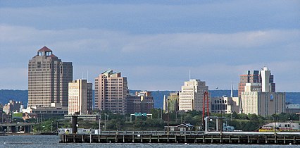
New England is a region comprising six states in the Northeastern United States: Connecticut, Maine, Massachusetts, New Hampshire, Rhode Island, and Vermont. It is bordered by the state of New York to the west and by the Canadian provinces of New Brunswick to the northeast and Quebec to the north. The Gulf of Maine and Atlantic Ocean are to the east and southeast, and Long Island Sound is to the southwest. Boston is New England's largest city and the capital of Massachusetts. Greater Boston is the largest metropolitan area, with nearly a third of New England's population; this area includes Worcester, Massachusetts, the second-largest city in New England, Manchester, New Hampshire, the largest city in New Hampshire, and Providence, Rhode Island, the capital of and largest city in Rhode Island.
In 1620, the
In the late 18th century, political leaders from the New England colonies initiated resistance to Britain's
The physical geography of New England is diverse. Southeastern New England is covered by a narrow
Each state is generally subdivided into small municipalities known as towns, many of which are governed by town meetings. Unincorporated areas are practically nonexistent outside of Maine, and village-style governments common in other areas are limited to Vermont and Connecticut. New England is one of the U.S. Census Bureau's nine regional divisions and the only multi-state region with clear and consistent boundaries. It maintains a strong sense of cultural identity,[4] although the terms of this identity are often contrasted, combining Puritanism with liberalism, agrarian life with industry, and isolation with immigration.
History

The earliest known inhabitants of New England were American Indians who spoke a variety of the
The Penobscots lived along the
As early as the year 1600, French, Dutch, and English traders began exploring the New World, trading metal, glass, and cloth for local beaver pelts.[5][8]
Colonial period

On April 10, 1606, King
In 1616, English explorer
Massachusetts Puritans began to establish themselves in Connecticut as early as 1633.
French and Indian Wars


Relationships alternated between peace and armed skirmishes between colonists and local Native American tribes, the bloodiest of which was the Pequot War in 1637 which resulted in the Mystic massacre.[22] On May 19, 1643, the colonies of Massachusetts Bay, Plymouth, New Haven, and Connecticut joined in a loose compact called the New England Confederation (officially "The United Colonies of New England"). The confederation was designed largely to coordinate mutual defense, and it gained some importance during King Philip's War[23] which pitted the colonists and their Indian allies against a widespread Indian uprising from June 1675 through April 1678, resulting in killings and massacres on both sides.[24] In the aftermath of settler-Native conflicts, hundreds of captive Indians were sold into slavery.[25][26] Up until 1700, Native Americans comprised a majority of the non-white labor force in colonial New England.[27]
During the next 74 years, there were six colonial wars that took place primarily between New England and
The New England Colonies were settled primarily by farmers who became relatively self-sufficient. Later, New England's economy began to focus on crafts and trade, aided by the
Dominion of New England
.svg)

By 1686,
The dominion significantly modified the charters of the colonies, including the appointment of royal governors to nearly all of them. There was an uneasy tension among the royal governors, their officers, and the elected governing bodies of the colonies. The governors wanted unlimited authority, and the different layers of locally elected officials would often resist them. In most cases, the local town governments continued operating as self-governing bodies, just as they had before the appointment of the governors.[37]
After the
New England in the new nation
After the dissolution of the Dominion of New England, the colonies of New England ceased to function as a unified political unit but remained a defined cultural region. There were often disputes over territorial jurisdiction, leading to land exchanges such as those regarding the Equivalent Lands and New Hampshire Grants.[39]
By 1784, all of the states in the region had taken steps towards the abolition of slavery, with Vermont and Massachusetts introducing total abolition in 1777 and 1783, respectively.[40] The nickname "Yankeeland" was sometimes used to denote the New England area, especially among Southerners and the British.[41]
Vermont was admitted to statehood in 1791 after settling a dispute with New York. The territory of Maine had been a part of Massachusetts, but it was granted statehood on March 15, 1820, as part of the Missouri Compromise.[42] Today, New England is defined as the six states of Maine, Vermont, New Hampshire, Massachusetts, Rhode Island, and Connecticut.[43]
New England's economic growth relied heavily on trade with the
Politically, the region often disagreed with the rest of the country.[47] Massachusetts and Connecticut were among the last refuges of the Federalist Party, and New England became the strongest bastion of the new Whig Party when the Second Party System began in the 1830s. The Whigs were usually dominant throughout New England, except in the more Democratic Maine and New Hampshire.
Industrial Revolution

New England was key to the
The
The rapid growth of textile manufacturing in New England between 1815 and 1860 caused a shortage of workers. Recruiters were hired by mill agents to bring young women and children from the countryside to work in the factories. Between 1830 and 1860, thousands of farm girls moved from rural areas where there was no paid employment to work in the nearby mills, such as the
New England as a whole was the most industrialized part of the United States. By 1850, the region accounted for well over a quarter of all manufacturing value in the country and over a third of its industrial workforce.[55] It was also the most literate and most educated region in the country.[55]
During the same period, New England and areas settled by New Englanders (upstate New York, Ohio's
20th century and beyond

The flow of immigrants continued at a steady pace from the 1840s until cut off by World War I. The largest numbers came from Ireland and Britain before 1890, and after that from Quebec, Italy, and Southern Europe. The immigrants filled the ranks of factory workers, craftsmen, and unskilled laborers. The Irish assumed a larger and larger role in the Democratic Party in the cities and statewide, while the rural areas remained Republican.
The
Boston figured prominently on the subject of securities laws in the early 1930s in response to the Great Depression. Harvard University professors Felix Frankfurter, Benjamin V. Cohen, and James M. Landis drafted the Securities Act of 1933 and the Securities Exchange Act of 1934. Joseph P. Kennedy Sr. was the first chairman of the U.S. Securities and Exchange Commission, and he was from Boston.[60]
The Democrats appealed to factory workers and especially Catholics, pulling them into the New Deal coalition and making the once-Republican region into one that was closely divided. However, the enormous spending on munitions, ships, electronics, and uniforms during World War II caused a burst of prosperity in every sector.
The region lost most of its factories starting with the loss of textiles in the 1930s and getting worse after 1960. The New England economy was radically transformed after World War II. The factory economy practically disappeared. Once-bustling New England communities fell into economic decay following the flight of the region's industrial base. The textile mills one by one went out of business from the 1920s to the 1970s. For example, the Crompton Company went bankrupt in 1984 after 178 years in business, costing the jobs of 2,450 workers in five states. The major reasons were cheap imports, the strong dollar, declining exports, and a failure to diversify.[61] The shoe industry subsequently left the region as well.

What remains is very high technology manufacturing, such as jet engines, nuclear submarines, pharmaceuticals, robotics, scientific instruments, and medical devices. The Massachusetts Institute of Technology invented the format for university-industry relations in high tech fields and spawned many software and hardware firms, some of which grew rapidly.[62] By the 21st century, the region had become famous for its leadership roles in the fields of education, medicine, medical research, high-technology, finance, and tourism.[63]
Some industrial areas were slow in adjusting to the new service economy. In 2000, New England had two of the ten poorest cities in the U.S. (by percentage living below the poverty line): the state capitals of Providence, Rhode Island and Hartford, Connecticut.[64] They were no longer in the bottom ten by 2010; Connecticut, Massachusetts, and New Hampshire remain among the ten wealthiest states in the United States in terms of median household income and per capita income.[65]
Geography


The states of New England have a combined area, including water surfaces, of 71,988 square miles (186,447 km2),[66] making the region slightly larger than the state of Washington and slightly smaller than Great Britain.[67][68] Maine alone constitutes nearly one-half of the total area of New England, yet is only the 39th-largest state, slightly smaller than Indiana. The remaining states are among the smallest in the U.S., including the smallest state—Rhode Island.
The areas of the states (including water area) are:
- Maine, 35,380 square miles (91,600 km2)
- Massachusetts, 10,554 square miles (27,330 km2)
- Vermont, 9,616 square miles (24,910 km2)
- New Hampshire, 9,349 square miles (24,210 km2)
- Connecticut, 5,543 square miles (14,360 km2)
- Rhode Island, 1,545 square miles (4,000 km2)[69]
Geology
New England's long rolling hills, mountains, and jagged coastline are
New England is geologically a part of the
The Appalachians extend northwards into New Hampshire as the
The coast of the region, extending from southwestern Connecticut to northeastern Maine, is dotted with lakes, hills, marshes and wetlands, and sandy beaches.
Climate

The climate of New England varies greatly across its 500 miles (800 km) span from northern Maine to southern Connecticut:
Maine, New Hampshire, Vermont, and western Massachusetts have a
In central and eastern Massachusetts, northern Rhode Island, and northern Connecticut, the same humid continental prevails (Dfa), though summers are warm to hot, winters are shorter, and there is less snowfall (especially in the coastal areas where it is often warmer).
Southern and coastal Connecticut is the broad transition zone from the cold
Regions

Biodiversity
New England contains forested ecosystems with a variety of terrestrial vertebrates. Land-use patterns and land disturbance, such as the dramatic increase in land clearing for agriculture in the mid eighteenth century to nineteenth century, greatly altered the ecosystem and resulted in extinctions, local extirpations, and recolonizations.[80]
According to an analysis of USDA Forest Service data, tree species diversity increases from north to south at about 2-3 species per degree in latitude. In addition, taller trees are associated with higher tree species diversity, and tree height is a better predictor than general forest age or biomass. Due to an increasing the amount of nitrogen in the soil from climate change, the red maple is becoming one of the most abundant trees in the region, and outcompeting other maples such as the sugar maple.[81]
Largest cities
The most populous cities as of the 2020 U.S. Census were (metropolitan areas in parentheses):[82][83]
 Boston, Massachusetts: 675,647 (4,941,632)
- Worcester, Massachusetts: 206,518 (923,672)
 Providence, Rhode Island: 190,934 (1,604,291)
- Springfield, Massachusetts: 155,929 (699,162)
 Bridgeport, Connecticut: 148,654 (939,904)
- Stamford, Connecticut: 135,470 (part of Greater Bridgeport)
- New Haven, Connecticut: 134,023 (862,477)
- Hartford, Connecticut: 121,054 (1,214,295)
- Cambridge, Massachusetts: 118,403 (part of Greater Boston)
 Manchester, New Hampshire: 115,644 (406,678)
During the 20th century, urban expansion in regions surrounding New York City has become an important economic influence on neighboring Connecticut, parts of which belong to the New York metropolitan area. The U.S. Census Bureau groups Fairfield, New Haven and Litchfield counties in western Connecticut together with New York City and other parts of New York and New Jersey as a combined statistical area.[84]
- Major cities of New England
-

-

-

-

-

-

-
-

-
-


Metropolitan areas and capitals
Metropolitan areas
The following are metropolitan statistical areas as defined by the United States Census Bureau.
| Rank | Metropolitan area | State(s) | Population (2020) | Encompassing CSA |
|---|---|---|---|---|
| 1 | Boston | 4,941,632 | Boston | |
| 2 | Providence | 1,676,579 | Boston | |
| 3 | Hartford | 1,213,531 | Hartford | |
| 4 | Worcester
|
978,529 | Boston | |
| 5 | Bridgeport | 957,419 | New York | |
| 6 | New Haven | 864,835 | Hartford | |
| 7 | Springfield | 699,162 | Springfield | |
| 8 | Portland | 551,740 | Portland | |
| 9 | Manchester-Nashua | 422,937 | Boston | |
| 10 | Norwich-New London | 268,555 | Hartford | |
| 11 | Barnstable | 228,996 | Boston | |
| 12 | Burlington | 225,562 | Burlington | |
| 13 | Bangor | 152,199 | — | |
| 14 | Pittsfield | 129,026 | — | |
| 15 | Lewiston-Auburn | 111,139 | Portland |
State capitals

- Hartford, Connecticut
- Augusta, Maine
- Boston, Massachusetts
- Concord, New Hampshire
- Providence, Rhode Island
- Montpelier, Vermont
Demographics

In 2020, New England had a population of 15,116,205, a growth of 4.6% from 2010.[86] Massachusetts is the most populous state with 7,029,917 residents, while Vermont is the least populous state with 643,077 residents.[86] Boston is by far the region's most populous city and metropolitan area.
Although a great disparity exists between New England's northern and southern portions, the region's average population density is 234.93 inhabitants/sq mi (90.7/km2). New England has a significantly higher population density than that of the U.S. as a whole (79.56/sq mi), or even just the contiguous 48 states (94.48/sq mi). Three-quarters of the population of New England, and most of the major cities, are in southern New England—the states of Connecticut, Massachusetts and Rhode Island—where the combined population density is 786.83/sq mi (2000 census). In northern New England—the states of Maine, New Hampshire, and Vermont—the combined population density is 63.56/sq mi (2000 census).
According to the 2006–08 American Community Survey, 48.7% of New Englanders were male and 51.3% were female. Approximately 22.4% of the population were under 18 years of age; 13.5% were over 65 years of age. The six states of New England have the lowest birth rate in the U.S.[87]

_(13202190293).jpg)
Puerto Ricans were the most numerous of the Hispanic and Latino subgroups. Over 660,000 Puerto Ricans lived in New England in 2014, forming 4.5% of the population. The Dominican population is over 200,000, and the Mexican and Guatemalan populations are each over 100,000.[88] Americans of Cuban descent are scant in number; there were roughly 26,000 Cuban Americans in the region in 2014. People of all other Hispanic and Latino ancestries, including Salvadoran, Colombian and Bolivian, formed 2.5% of New England's population and numbered over 361,000 combined.[88]
According to the 2014 American Community Survey, the top ten largest reported European ancestries were the following:: 1.0% (152,000).
English is, by far, the most common language spoken at home. Approximately 81.3% of all residents (11.3 million people) over the age of five spoke only English at home. Roughly 1,085,000 people (7.8% of the population) spoke Spanish at home, and roughly 970,000 people (7.0% of the population) spoke other Indo-European languages at home. Over 403,000 people (2.9% of the population) spoke an Asian or Pacific Island language at home.[92] Slightly fewer (about 1%) spoke French at home,[93] although this figure is above 20% in northern New England, which borders francophone Québec.[citation needed] Roughly 99,000 people (0.7% of the population) spoke languages other than these at home.[92]
As of 2014, approximately 87% of New England's inhabitants were born in the U.S., while over 12% were foreign-born.[94] 35.8% of foreign-born residents were born in Latin America, 28.6% were born in Asia,[95] 22.9% were born in Europe, and 8.5% were born in Africa.[96]
Southern New England forms an integral part of the
Economy

Several factors combine to make the New England economy unique. The region is distant from the geographic center of the country, and it is a relatively small region but densely populated. It historically has been an important center of industry and manufacturing and a supplier of natural resource products, such as granite, lobster, and
The region underwent a long period of deindustrialization in the first half of the 20th century, as traditional manufacturing companies relocated to the Midwest, with textile and furniture manufacturing migrating to the South. In the late-20th century, an increasing portion of the regional economy included high technology, military defense industry, finance and insurance services, and education and health services. As of 2018, the GDP of New England was $1.1 trillion.[99]
New England exports food products ranging from fish to lobster, cranberries, potatoes, and maple syrup. About half of the region's exports consist of industrial and commercial machinery, such as computers and electronic and electrical equipment. Granite is quarried at Barre, Vermont,[100] guns made at Springfield, Massachusetts, and Saco, Maine, submarines at Groton, Connecticut, surface naval vessels at Bath, Maine, and hand tools at Turners Falls, Massachusetts.
Urban centers

In 2017, Boston was ranked as having the ninth-most competitive financial center in the world and the fourth-most competitive in the United States.[101] Boston-based Fidelity Investments helped popularize the mutual fund in the 1980s and has made Boston one of the top financial centers in the United States.[102] The city is home to the headquarters of Santander Bank and a center for venture capital firms. State Street Corporation specializes in asset management and custody services and is based in the city.
Boston is also a printing and publishing center.
The
Hartford is the historic international center of the insurance industry, with companies such as
Fairfield County, Connecticut, has a large concentration of investment management firms in the area, most notably Bridgewater Associates (one of the world's largest hedge fund companies), Aladdin Capital Management and Point72 Asset Management. Moreover, many international banks have their North American headquarters in Fairfield County, such as NatWest Group and UBS.
Agriculture

Agriculture is limited by the area's rocky soil, cool climate, and small area. Some New England states, however, are ranked highly among U.S. states for particular areas of production. Maine is ranked ninth for aquaculture,[109] and has abundant potato fields in its northeast part. Vermont is fifteenth for dairy products,[110] and Connecticut and Massachusetts seventh and eleventh for tobacco, respectively.[111][112] Cranberries are grown in Massachusetts' Cape Cod-Plymouth-South Shore area, and blueberries in Maine.
Energy

The region is mostly energy-efficient compared to the U.S. at large, with every state but Maine ranking within the ten most energy-efficient states;[113] every state in New England also ranks within the ten most expensive states for electricity prices.[114] Wind power, mainly from offshore sources, is expected to gain market share in the 2020s.
Employment
| Employment area | October 2010 | October 2011 | October 2012 | October 2013 | December 2014 | December 2015[115] | December 2016[116] | Net change |
|---|---|---|---|---|---|---|---|---|
| United States | 9.7 | 9.0 | 7.9 | 7.2 | 5.6 | 5.0 | 4.7 | −5.0 |
| New England | 8.3 | 7.6 | 7.4 | 7.1 | 5.4 | 4.3 | 3.5 | −4.7 |
| Connecticut | 9.1 | 8.7 | 9.0 | 7.6 | 6.4 | 5.2 | 4.4 | −4.7 |
| Maine | 7.6 | 7.3 | 7.4 | 6.5 | 5.5 | 4.0 | 3.8 | −3.8 |
| Massachusetts | 8.3 | 7.3 | 6.6 | 7.2 | 5.5 | 4.7 | 2.8 | −5.5 |
| New Hampshire | 5.7 | 5.3 | 5.7 | 5.2 | 4.0 | 3.1 | 2.6 | −3.1 |
| Rhode Island | 11.5 | 10.4 | 10.4 | 9.4 | 6.8 | 5.1 | 5.0 | −6.5 |
| Vermont | 5.9 | 5.6 | 5.5 | 4.4 | 4.2 | 3.6 | 3.1 | −2.8 |
As of January 2017, employment is stronger in New England than in the rest of the United States. During the Great Recession, unemployment rates ballooned across New England as elsewhere; however, in the years that followed, these rates declined steadily, with New Hampshire and Massachusetts having the lowest unemployment rates in the country, respectively. The most extreme swing was in Rhode Island, which had an unemployment rate above 10% following the recession, but which saw this rate decline by over 6% in six years.
As of December 2016, the metropolitan statistical area (MSA) with the lowest unemployment rate, 2.1%, was Burlington-South Burlington, Vermont; the MSA with the highest rate, 4.9%, was Waterbury, Connecticut.[117]
Overall tax burden
In 2023, three of the six New England states were among the top ten states in the country in terms of taxes paid per taxpayer, while one was among the top five least. The rankings being #3 Maine (11.14%), #4 Vermont (10.28%), #5 Connecticut (9.83%), #11 Rhode Island (9.07%), #20 Massachusetts (8.48%), and #48 New Hampshire (6.14%). While overall tax burden varies widely, all six states sport exceptionally high property taxes with five of the six states being within the nationwide top 10. The rankings being #1 Maine (5.33%), #2 Vermont (4.98%), #3 New Hampshire (4.94%), #6 Connecticut (4.24%), #7 Rhode Island (4.17%), and #13 Massachusetts (3.42%).[118]
Government
Town meetings
New England, where education and liberty are the daughters of morality and religion, where society has acquired age and stability enough to enable it to form principles and hold fixed habits, the common people are accustomed to respect intellectual and moral superiority and to submit to it without complaint, although they set at naught all those privileges which wealth and birth have introduced among mankind. In New England, consequently, the democracy makes a more judicious choice than it does elsewhere.[119]
By contrast,
Politics
Elections
State and national elected officials in New England recently have been elected mainly from the Democratic Party.[122] The region is generally considered to be the most liberal in the United States, with more New Englanders identifying as liberals than Americans elsewhere. In 2010, four of six of the New England states were polled as the most liberal in the United States.[123]

As of 2021, five of the six states of New England have voted for every Democratic presidential nominee since 1992. In that time, New Hampshire has voted for Democratic nominees in every presidential election except 2000, when
, an Independent representing Maine.In the
The following table presents the vote percentage for the popular-vote winner for each New England state, New England as a whole, and the United States as a whole, in each presidential election from 1900 to 2020, with the vote percentage for the Republican candidate shaded in red and the vote percentage for the Democratic candidate shaded in blue:
| Year | Connecticut | Maine | Massachusetts | New Hampshire | Rhode Island | Vermont | New England | United States |
|---|---|---|---|---|---|---|---|---|
| 2020 | 59.2% | 53.1% | 65.6% | 52.7% | 59.4% | 66.1% | 61.2% | 51.3% |
| 2016 | 54.6% | 47.8% | 60.0% | 46.8% | 54.4% | 56.7% | 55.3% | 48.2% |
| 2012 | 58.1% | 56.3% | 60.7% | 52.0% | 62.7% | 66.6% | 59.1% | 51.1% |
| 2008 | 60.6% | 57.7% | 61.8% | 54.1% | 62.9% | 67.5% | 60.6% | 52.9% |
| 2004 | 54.3% | 53.6% | 61.9% | 50.2% | 59.4% | 58.9% | 57.7% | 50.7% |
| 2000 | 55.9% | 49.1% | 59.8% | 48.1% | 61.0% | 50.6% | 56.1% | 48.4% |
| 1996 | 52.8% | 51.6% | 61.5% | 49.3% | 59.7% | 53.4% | 56.8% | 49.2% |
| 1992 | 42.2% | 38.8% | 47.5% | 38.9% | 47.0% | 46.1% | 44.4% | 43.0% |
| 1988 | 52.0% | 55.3% | 53.2% | 62.5% | 55.6% | 51.1% | 49.5% | 53.4% |
| 1984 | 60.7% | 60.8% | 51.2% | 68.7% | 51.7% | 57.9% | 56.2% | 58.8% |
| 1980 | 48.2% | 45.6% | 41.9% | 57.7% | 47.7% | 44.4% | 44.7% | 50.8% |
| 1976 | 52.1% | 48.9% | 56.1% | 54.7% | 55.4% | 54.3% | 51.7% | 50.1% |
| 1972 | 58.6% | 61.5% | 54.2% | 64.0% | 53.0% | 62.7% | 52.5% | 60.7% |
| 1968 | 49.5% | 55.3% | 63.0% | 52.1% | 64.0% | 52.8% | 56.1% | 43.4% |
| 1964 | 67.8% | 68.8% | 76.2% | 63.9% | 80.9% | 66.3% | 72.8% | 61.1% |
| 1960 | 53.7% | 57.0% | 60.2% | 53.4% | 63.6% | 58.6% | 56.0% | 49.7% |
| 1956 | 63.7% | 70.9% | 59.3% | 66.1% | 58.3% | 72.2% | 62.0% | 57.4% |
| 1952 | 55.7% | 66.0% | 54.2% | 60.9% | 50.9% | 71.5% | 56.1% | 55.2% |
| 1948 | 49.5% | 56.7% | 54.7% | 52.4% | 57.6% | 61.5% | 51.5% | 49.6% |
| 1944 | 52.3% | 52.4% | 52.8% | 52.1% | 58.6% | 57.1% | 52.4% | 53.4% |
| 1940 | 53.4% | 51.1% | 53.1% | 53.2% | 56.7% | 54.8% | 52.8% | 54.7% |
| 1936 | 55.3% | 55.5% | 51.2% | 49.7% | 53.1% | 56.4% | 50.9% | 60.8% |
| 1932 | 48.5% | 55.8% | 50.6% | 50.4% | 55.1% | 57.7% | 49.1% | 57.4% |
| 1928 | 53.6% | 68.6% | 50.2% | 58.7% | 50.2% | 66.9% | 53.2% | 58.2% |
| 1924 | 61.5% | 72.0% | 62.3% | 59.8% | 59.6% | 78.2% | 63.3% | 54.0% |
| 1920 | 62.7% | 68.9% | 68.5% | 59.8% | 64.0% | 75.8% | 66.7% | 60.3% |
| 1916 | 49.8% | 51.0% | 50.5% | 49.1% | 51.1% | 62.4% | 51.1% | 49.2% |
| 1912 | 39.2% | 39.4% | 35.5% | 39.5% | 39.0% | 37.1% | 36.6% | 41.8% |
| 1908 | 59.4% | 63.0% | 58.2% | 59.3% | 60.8% | 75.1% | 60.2% | 51.6% |
| 1904 | 58.1% | 67.4% | 57.9% | 60.1% | 60.6% | 78.0% | 60.4% | 56.4% |
| 1900 | 56.9% | 61.9% | 57.6% | 59.3% | 59.7% | 75.7% | 59.4% | 51.6% |
Political party strength
Judging purely by party registration rather than voting patterns, New England today is one of the most Democratic regions in the U.S.
| State | Governor | Senior U.S. Senator | Junior U.S. Senator | U.S. House Delegation | Upper House Majority | Lower House Majority |
|---|---|---|---|---|---|---|
| CT | N. Lamont | R. Blumenthal | C. Murphy | Democratic 5–0 | Democratic 24–12 | Democratic 97–54 |
| ME | J. Mills | S. Collins | A. King[†] | Democratic 2-0 | Democratic 22–13 | Democratic 82–67–2 |
| MA | M. Healey | E. Warren | E. Markey | Democratic 9–0 | Democratic 37–3 | Democratic 132–25–1 |
| NH | C. Sununu | J. Shaheen | M. Hassan | Democratic 2-0 | Republican 14–10 | Republican 198-196-3 |
| RI | D. McKee | J. Reed | S. Whitehouse | Democratic 2–0 | Democratic 33–5 | Democratic 65-9-1 |
| VT | P. Scott | B. Sanders[†] | P. Welch | Democratic 1–0 | Democratic 22–7–1 | Democratic 104–38–5–3 |
| :† Elected as an independent, but caucuses with the Democratic Party. | ||||||
New Hampshire primary
Education
Colleges and universities

New England contains some of the oldest and most renowned institutions of higher learning in the United States and the world.
In addition to four out of eight
Private and independent secondary schools

At the pre-college level, New England is home to a number of American independent schools (also known as private schools). The concept of the elite "New England
- See the list of private schools for each state:
Connecticut, Massachusetts, Maine, New Hampshire, Rhode Island, Vermont.
Public education
New England is home to some of the oldest public schools in the nation and was the first region in the United States to implement universal
As of 2005, the National Education Association ranked Connecticut as having the highest-paid teachers in the country. Massachusetts and Rhode Island ranked eighth and ninth, respectively.
New Hampshire, Rhode Island, and Vermont have cooperated in developing a
Academic journals and press
There are several academic journals and publishing companies in the region, including
Culture

New England has a shared heritage and culture primarily shaped by waves of immigration from Europe.[140] In contrast to other American regions, many of New England's earliest Puritan settlers came from eastern England, contributing to New England's distinctive accents, foods, customs, and social structures.[141]: 30–50 Within modern New England a cultural divide exists between urban New Englanders living along the densely populated coastline, and rural New Englanders in western Massachusetts, northwestern and northeastern Connecticut, Vermont, New Hampshire, and Maine, where population density is low.[142] There is also a substantial divide between Connecticut and the other states of the region, owing to the former's close cultural and economic ties with the New York metropolitan area.[143][144]
Religion
Today, New England is the least religious region of the U.S. In 2009, less than half of those polled in Maine, Massachusetts, New Hampshire, and Vermont claimed that religion was an important part of their daily lives. Connecticut and Rhode Island are among the ten least religious states, where 55% and 53% of those polled (respectively) claimed that it was important.
Cultural roots
Many of the first European colonists of New England had a
New England has largely preserved its regional character, especially in its historic places. The region has become more
Cuisine


.jpg)
New England maintains a distinct cuisine and food culture. Early foods in the region were influenced by Native American and English cuisines. The early colonists often adapted their original cuisine to fit with the available foods of the region. New England staples reflect the convergence of American Indian and Pilgrim cuisine, such as johnnycakes, succotash, cornbread and various seafood recipes. The Wabanaki tribal nations made nut milk.[148]
New England also has a distinct food language. A few of the unique regional terms include "grinders" for submarine sandwiches and "frappes" for thick milkshakes, referred to as "Cabinets" in Rhode Island. Other foods native to the region include steak tips (marinated sirloin steak), bulkie rolls, maple syrup, cranberry recipes and clam chowder.[149]
A type of India pale ale known as New England India Pale Ale (NEIPA) was developed in Vermont in the 2010s.[150][151] Other regional beverages include Moxie, one of the first mass-produced soft drinks in the United States, introduced in Lowell, Massachusetts, in 1876; it remains popular in New England, particularly in Maine.[152] Coffee milk is associated with Rhode Island as the official state drink.[153]
Portuguese cuisine is an important element in the annual Feast of the Blessed Sacrament in New Bedford, Massachusetts, the largest ethnic heritage festival in New England.[154]
Accents and dialects
There are several
Some Rhode Islanders speak with a non-rhotic accent that many compare to a "Brooklyn" accent or a cross between a New York and Boston accent, where "water" becomes "wata". Many Rhode Islanders distinguish the aw sound [ɔː], as one might hear in New Jersey; e.g., the word "coffee" is pronounced /ˈkɔːfi/ KAW-fee.[157] This type of accent was brought to the region by early settlers from eastern England in the Puritan migration in the mid-seventeenth century.[141]: 13–207
Social activities and music
New England leads the U.S. in ice cream consumption per capita.[158][159]
Candlepin bowling is essentially confined to New England, where it was invented in the 19th century.[160]

New England was an important center of
In popular music, the region has produced
.Media
The leading U.S. cable TV sports broadcaster
NESN broadcasts the
NBC Sports Boston broadcasts the games of the Boston Celtics, New England Revolution and Boston Cannons to all of New England except Fairfield County.
While most New England cities have daily newspapers, The Boston Globe and The New York Times are distributed widely throughout the region. Major newspapers also include The Providence Journal, Portland Press Herald, and Hartford Courant, the oldest continuously published newspaper in the U.S.[163]
Comedy
New Englanders are well represented in American comedy. Writers for
Late-night television hosts
Literature

New Englanders have made significant contributions to literature. The first printing press in America was set up in Cambridge, Massachusetts, by Stephen Daye in the 17th century.[citation needed] Writers in New England produced many works on religious subjects, particularly on Puritan theology and poetry during colonial times and on Enlightenment ideas during the American Revolution. The literature of New England has had an enduring influence on American literature in general, with themes that are emblematic of the larger concerns of American letters, such as religion, race, the individual versus society, social repression and nature.[167]
19th century New England was a center for progressive ideals, and many
Boston was the center of the American publishing industry for some years, largely on the strength of its local writers and before it was overtaken by New York in the middle of the nineteenth century. Boston remains the home of publishers
Many New Englander poets have also been preeminent in American poetry. Prominent poets include Henry Wadsworth Longfellow, David Lindsay-Abaire, Annie Proulx, Edwin Arlington Robinson, Amy Lowell, John Cheever, Emily Dickinson, Elizabeth Bishop, Stanley Kunitz, E. E. Cummings, Edna St. Vincent Millay, Robert P. T. Coffin and Richard Wilbur. Robert Frost who was described as an "artistic institution"[169] frequently wrote about rural New England life. The Confessional poetry movement features prominent New England writers including Robert Lowell, Anne Sexton and Sylvia Plath.
Film, television, and acting
New England has a rich history in
Since the turn of the millennium, Boston and the greater New England region have been home to the production of numerous films and television series, thanks in part to tax incentive programs put in place by local governments to attract filmmakers to the region.[172]

Notable actors and actresses that have come from the New England area include Ben Affleck, Matt Damon, Chris Evans, Ryan O'Neal, Amy Poehler, Elizabeth Banks, Steve Carell, Ruth Gordon, John Krasinski, Edward Norton, Mark Wahlberg and Matthew Perry. Many films and television series have been produced in and set in New England.
Museums, historical societies, and libraries

There are many museums located throughout New England, especially in the Greater Boston area. These museums include privately held collections as well as public institutions. Most notable of these museums are the Museum of Fine Arts, the Institute of Contemporary Art, Boston, the Isabella Stewart Gardner Museum, Worcester Art Museum, and the Peabody Essex Museum. The oldest public museum in continuous operation in the United States is the Pilgrim Hall Museum in Plymouth, Massachusetts, which opened in 1824.
The Boston Public Library is the largest public library in the region with over 8 million materials in its collection. The largest academic research library in the world is the Harvard Library in Cambridge, Massachusetts. The W. E. B. Du Bois Library of the University of Massachusetts Amherst is the tallest academic library in the world.[173]
There are also many
Sports
New England has a strong heritage of athletics, and many internationally popular sports were invented and codified in the region, including basketball, volleyball, and American football.
Football is the most popular sport in the region and was developed by
Before the advent of modern rules of baseball, a different form was played called
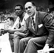
Basketball was developed in
Winter sports are extremely popular and have a long history in the region, including
Volleyball was invented in Holyoke, Massachusetts, in 1895 by William G. Morgan. Morgan was an instructor at a YMCA and wanted to create an indoor game for his athletes. The game was based on badminton and was spread as a sport through YMCA facilities. The international Volleyball Hall of Fame is located in Holyoke.
Rowing, sailing, and yacht racing are also popular events in New England. The
The
New England is represented in the top level of American professional soccer by the
-
 Harvard vs. Yale football game in 2003
 -

-
-
 The New England Patriots are the most popular professional sports team in New England.
 -
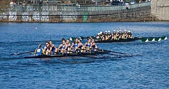 TheHead of the Charles Regatta


.jpg)

Transportation


Each of the New England states has its own Department of Transportation which plans and develops systems for transport, though some transportation authorities operate across state and municipal lines. The
Amtrak provides interstate rail service throughout New England. Boston is the northern terminus of the Northeast Corridor. The Vermonter connects Vermont to Massachusetts and Connecticut, while the Downeaster links Maine to Boston. The long-distance Lake Shore Limited train has two eastern termini after splitting in Albany, one of which is Boston. This provides rail service on the former Boston and Albany Railroad which runs between its namesake cities. The rest of the Lake Shore Limited continues to New York City.
Bus transportation is available in most urban areas and is governed by regional and local authorities. The Pioneer Valley Transit Authority and the MetroWest Regional Transit Authority are examples of public bus transportation which support more suburban and rural communities.
See also
- Atlantic Northeast
- Autumn in New England
- Brother Jonathan
- Extreme points of New England
- Fieldstone
- Historic New England
- List of beaches in New England
- List of birds of New England
- List of mammals of New England
- Manor of East Greenwich
- New Albion
- New Albion (colony)
- New England–Acadian forests
- New England Confederation
- New England (medieval)
- New England Planters
- New England Summer Nationals
- Northeastern coastal forests
- Offshore wind power
- Southeastern New England AVA wine region
- Swamp Yankee
References
Citations
- ^ "Yankee". The American Heritage Dictionary. Boston, MA: Houghton Mifflin Company. 2000. Retrieved March 28, 2011.
- ^ "Novanglian". Merriam-Webster. Retrieved May 11, 2023.
- ^ "GDP by State". GDP by State | U.S. Bureau of Economic Analysis (BEA). Bureau of Economic Analysis. Retrieved April 10, 2022.
- ISBN 9781584657941. Retrieved October 12, 2016.
- ^ a b c d Bain, Angela Goebel; Manring, Lynne; and Mathews, Barbara. Native Peoples in New England. Retrieved July 21, 2010, from Pocumtuck Valley Memorial Association.
- ^ "Abenaki History". abenakination.org. Retrieved March 28, 2011.
- ISBN 9780665608186. Retrieved March 28, 2011.
Norridgewock history.
- ^ Wiseman, Fred M. "The Voice of the Dawn: An Autohistory of the Abenaki Nation". p. 70. Retrieved March 28, 2011.
- ^ "What are the oldest cities in America?". Glo-con.com. Archived from the original on September 28, 2007. Retrieved August 11, 2007.
- ^ Cressy, David (1987). Coming Over: Migration and Communication Between England and New England in the Seventeenth Century. p. 4. Cambridge University Press.
- ^ Swindler, William F., ed; Sources and Documents of United States Constitutions 10 Volumes; Dobbs Ferry, New York; Oceana Publications, 1973–1979. Volume 5: pp. 16–26.
- ^ "joint stock company organized in 1620 by a charter from the British crown with authority to colonize and govern the area now known as New England." New England, Council for. (2006). In Encyclopædia Britannica. Retrieved July 13, 2006, from Encyclopædia Britannica Premium Service: Britannica.com Archived February 12, 2005, at the Wayback Machine
- ^ Haxtun, Anne Arnoux (1896). Signers of the Mayflower Compact, vol. 1. New York: The Mail and Express Publishing Company. Retrieved March 29, 2011.
- ^ Townsend, Edward Waterman (1906). Our Constitution: How and Why It Was Made. New York: Moffat, Yard & Company. p. 42. Retrieved March 29, 2011.
mayflower compact.
- ^ Secretary of the Commonwealth of Massachusetts. "Public Records: The History of the Arms and Great Seal of the Commonwealth of Massachusetts". sec.state.ma.us. Retrieved March 29, 2011.
- ^ Northend, William Dummer (1896). The Bay Colony: A Civil, Religious and Social History of the Massachusetts Colony. Boston: Estes and Lauriat. p. 305.
charter.
- ^ "History of Boston, Massachusetts". U-S-History.com. Retrieved August 17, 2016.
- ^ State of Connecticut. "About Connecticut". CT.gov. Archived from the original on April 29, 2011. Retrieved March 28, 2011.
- ^ Peace, Nancy E. (November 1976). "Roger Williams—A Historiographical Essay" (PDF). Rhode Island History. Providence RI: The Rhode Island Historical Society. pp. 103–115. Retrieved March 28, 2011.
- ^ "History & Famous Rhode Islanders". Rhode Island Tourism Division. Retrieved March 28, 2011.
- ^ Hall, Hiland (1868). The History of Vermont: From Its Discovery to Its Admission into the Union. Albany NY: Joel Munsell. p. 3.
history of vermont.
- ^ "1637 - The Pequot War". The Society of Colonial Wars in the State of Connecticut. Retrieved December 14, 2013.
- ^ Howe, Daniel Wait (1899). The Puritan Republic of the Massachusetts Bay in New England. Indianapolis: Bowen-Merrill. pp. 308–311.
- ^ "1675 - King Philip's War". The Society of Colonial Wars in the State of Connecticut. Retrieved December 14, 2013.
- Project MUSE book 64409.
- Project MUSE book 57597.
- ^ Newell, M. E. (2009). "Indian slavery in colonial America." In A. Gallay (Ed.), Indian slavery in colonial America (pp. 33-66). University of Nebraska Press.
- Father Rale's War and Father Le Loutre's Warfor more information.
- ISBN 0-451-62600-1.
- ^ Martucci, David B. "The New England Flag". D. Martucci. Archived from the original on April 1, 2007. Retrieved July 25, 2008.
- ^ "Flags of the Early North American Colonies and Explorers". Historical Flags of Our Ancestors.
- ISBN 9781429906470.
- ^ Various (1908). Proceedings of the First New England Conference: Called by the Governors of the New England States, Boston, Nov. 23, 24, 1908. Boston: Wright & Potter Printing Company. p. 6.
- ^ Preble, George Henry (1880). History of the Flag of the United States of America: And of the Naval and Yacht-club Signals, Seals, and Arms, and Principal National Songs of the United States, with a Chronicle of the Symbols, Standards, Banners, and Flags of Ancient and Modern Nations. Boston: A. Williams. p. 190.
- ^ Stark, Bruce P. "The Dominion of New England". Connecticut Humanities Council. Retrieved March 30, 2011.
- ^ Palfrey, John Gorham (1865). History of New England, vol. 3. Boston: Little, Brown, and Company. pp. 561–590. Retrieved March 30, 2011.
- ^ Palfrey, John Gorham (1873). A Compendious History of New England, vol. 3. Boston: H.C. Shepard. Retrieved March 30, 2011.
- ^ Wesley Frank Craven, Colonies in Transition, 1660 – 1713 (1968). p. 224.
- ^ "The Equivalent Lands and Fort Dummer". Brattleboro History. Valley Historians. Archived from the original on September 15, 2017. Retrieved March 10, 2017.
- ^ Harper, Douglas. "Slavery in New Hampshire". Slavenorth.com. Retrieved August 17, 2016.
- ^ "Yankeeland". The Random House Dictionary. Boston: Random House. 2013. Retrieved September 5, 2013.
- ^ Library of Congress. "Missouri Compromise: Primary Documents of American History". Library of Congress. Retrieved March 30, 2011.
- ^ "New England". Encyclopædia Britannica. Retrieved October 16, 2010.
- ^ James Schouler, History of the United States, Vol. 1 (New York: Dodd, Mead & Company. 1891; copyright expired)
- ^ Dwight, Theodore (1833). History of the Hartford Convention. New York: N. & J. White. Retrieved March 30, 2011.
hartford convention.
- ^ Hickey, Donald R. The War of 1812: A Forgotten Conflict. University of Illinois Press. p. 233.
- ^ Cooper, Thomas Valentine; Fenton, Hector Tyndale (1884). American Politics (Non-Partisan) from the Beginning to Date, Book III. Chicago: C. R. Brodix. pp. 64–69.
- Microsoft Encarta Online Encyclopedia 2006. New England - Further Reading - MSN Encarta. Archived from the originalon October 13, 2006. Retrieved November 22, 2009.
- ^ "History & Culture: Birthplace of the American Industrial Revolution". Blackstone River Valley National Heritage Corridor, MA, RI. National Park Service. June 11, 2009. Retrieved April 4, 2016.
- ^ Bagnall, William R. The Textile Industries of the United States: Including Sketches and Notices of Cotton, Woolen, Silk, and Linen Manufacturers in the Colonial Period. Vol. I. pg. 97. The Riverside Press, 1893.
- ^ "Forging Arms for the Nation". Springfield Armory National Historic Site, Massachusetts. National Park Service. Retrieved April 4, 2016.
- ^ Coen, Scott (May 13, 2011). "The Springfield Armory: The Heartbeat of the 19th Century Industrial Revolution". MassLive.com. Retrieved April 4, 2016.
- ^ Rooker, Sarah. "The Industrial Revolution: Connecticut River Valley Overview". Teaching the Industrial Revolution. The Flow of History. Archived from the original on March 5, 2016. Retrieved April 4, 2016.
- ^ Dublin, Thomas. "Lowell Millhands". Transforming Women's Work (1994) pp. 77–118.
- ^ a b "Census Data for Year 1850". Historical Census Browser. University of Virginia Library. Archived from the original on April 24, 2016. Retrieved April 4, 2016.
- ^ Wyatt-Brown, Bertram. "American Abolitionism and Religion". Divining America: Religion in American History. National Humanities Center TeacherServe. Retrieved April 4, 2016.
- ^ ISBN 978-0-87289-769-4. Retrieved April 19, 2015.
- ^ "Senate: Friday March 31, 1933" (PDF). Congressional Record–Senate. p. 1069. Retrieved August 30, 2021.
- ^ Thorndike, Joseph J. (November 10, 2003). "Historical Perspective: Pecora Hearings Spark Tax Morality, Tax Reform Debate". taxhistory.org. Retrieved August 30, 2021.
- ^ 431 Days: Joseph P. Kennedy and the Creation of the SEC (1934-35) (Progressive Reform and the Securities Act) | Galleries | Virtual Museum and Archive of the History of Financial Regulation (sechistorical.org)
- S2CID 145693630.
- ^ Henry Etzkowitz, MIT and the Rise of Entrepreneurial Science (Routledge 2007)
- ^ David Koistinen, Confronting Decline: The Political Economy of Deindustrialization in Twentieth-Century New England (2013)
- ^ Bishaw, Alemayehu; Iceland, John (May 2003). "Poverty: 1999" (PDF). Census 2000 Brief. US Census Bureau. Retrieved August 17, 2016.
- ^ "Income in the Past 12 Months (in 2014 Inflation-Adjusted Dollars): 2014 American Community Survey 1-Year Estimates (S1901)". American Factfinder. United States Census Bureau. Archived from the original on February 13, 2020. Retrieved April 4, 2016.
- ^ "State Area Measurements and Internal Point Coordinates". United States Census Bureau. Retrieved February 3, 2022.
- ^ "Part 1: Population and Housing Unit Counts" (PDF). 2000 Census of Population and Housing – United States Summary: 2000. United States Census Bureau. April 2004. Retrieved April 4, 2016.
- ^ "The British Isles and all that ..." Heriot-Watt University, Edinburgh. Retrieved March 7, 2011.
- ^ "State Area Measurements and Internal Point Coordinates". Geography Division, U.S. Census Bureau. Retrieved May 13, 2021.
- ^ "Glacial Features of the Exotic Terrane". The Teacher-Friendly Guide to the Earth Science of the Northeastern US. Paleontological Research Institution. Retrieved April 4, 2016.
- ^ a b c d Emerson, Philip (1922). The Geography of New England. New York: The Macmillan Company. Retrieved March 28, 2011.
- ^ "Physiographic divisions of the conterminous U.S." U.S. Geological Survey. Retrieved December 23, 2011.
- ^ "Topography of the Appalachian/Piedmont Region 2". The Teacher-Friendly Guide to the Earth Science of the Northeastern US. Paleontological Research Institution. Retrieved April 4, 2016.
- ^ Shaw, Ethan. "The 10 Tallest Mountains East of the Mississippi". USA Today. Retrieved April 4, 2016.
- ^ "World Record Wind". Mount Washington Observatory. Archived from the original on May 5, 2012. Retrieved April 4, 2016.
- ^ "World Record Wind Gust: 408 km/h". World Meteorological Organization. January 22, 2010. Archived from the original on July 22, 2011. Retrieved May 27, 2011.
- ^ "About Us". Mount Washington Observatory. Archived from the original on October 23, 2014. Retrieved April 4, 2016.
- ^ Hrin, Eric (March 26, 2011). "Wolfe turns love of books into career; One-hundredth anniversary of library in Troy approaching". The Daily Review. Towanda, PA. Archived from the original on July 30, 2012. Retrieved May 28, 2011.
- ^ "New England's Fall Foliage". Discover New England. Archived from the original on August 16, 2007. Retrieved May 28, 2011.
- ISBN 978-94-010-7180-2, retrieved June 5, 2023
- S2CID 256431037.
- ^ a b "Annual Estimates of the Resident Population: April 1, 2010 to July 1, 2015 - United States -- Metropolitan and Micropolitan Statistical Area: 2015 Population Estimates (GCT-PEPANNRES)". American Factfinder. U.S. Census Bureau. Archived from the original on February 13, 2020. Retrieved April 4, 2016.
- ^ "Annual Estimates of the Resident Population for Incorporated Places: April 1, 2010 to July 1, 2014". U.S. Census Bureau. Archived from the original on May 22, 2015. Retrieved April 4, 2016.
- ^ "TIGERweb". U.S. Census Bureau. (Combined Statistical Areas checkbox). Retrieved April 4, 2016.
- ^ "Montpelier". Fodor's. April 1, 2016. Retrieved March 19, 2021.
- ^ a b "Change in Resident Population of the 50 States, the District of Columbia, and Puerto Rico: 1910 to 2020" (PDF). United States Census Bureau. Retrieved June 13, 2021.
- PMID 22145497. Retrieved April 4, 2016.
- ^ a b "Hispanic or Latino Origin by Specific Origin: 2014 American Community Survey 1-Year Estimates: New England Division (B03001)". American Factfinder. U.S. Census Bureau. Archived from the original on February 13, 2020. Retrieved April 4, 2016.
- ^ "People Reporting Ancestry: 2014 American Community Survey 1-Year Estimates: New England Division (B04006)". American Factfinder. U.S. Census Bureau. Archived from the original on February 13, 2020. Retrieved April 4, 2016.
- ^ Includes English and "British" but not Scottish or Welsh.
- S2CID 244283614.
- ^ a b "Language Spoken at Home: 2014 American Community Survey 1-Year Estimates: New England Division (S1601)". American Factfinder. U.S. Census Bureau. Archived from the original on February 13, 2020. Retrieved April 4, 2016.
- ^ "Language Spoken at Home by Ability to Speak English for the Population 5 Years and Over: 2014 American Community Survey 1-Year Estimates: New England Division (B16001)". American Factfinder. U.S. Census Bureau. Archived from the original on February 13, 2020. Retrieved April 4, 2016.
- ^ "Selected Characteristics of the Native and Foreign-Born Populations: 2014 American Community Survey 1-Year Estimates: New England Division (S0501)". American Factfinder. U.S. Census Bureau. Archived from the original on February 13, 2020. Retrieved April 4, 2016.
- ^ Monica Chiu, ed. Asian Americans in New England: Culture and Community (University of New Hampshire Press, 2009) 252 pp.
- ^ "Place of Birth for the Foreign-Born Population in the United States: 2014 American Community Survey 1-Year Estimates: New England Division (B05006)". American Factfinder. U.S. Census Bureau. Archived from the original on February 13, 2020. Retrieved April 4, 2016.
- ^ "Annual Estimates of the Resident Population: April 1, 2010 to July 1, 2015 - United States -- Combined Statistical Area: 2015 Population Estimates (GCT-PEPANNRES)". American Factfinder. U.S. Census Bureau. Archived from the original on February 13, 2020. Retrieved April 4, 2016.
- ^ "Background on the New England Economy". U.S. Department of Commerce. Archived from the original on September 19, 2002.
- ^ "Regional Data: GDP & Personal Income". Bureau of Economic Analysis. U.S. Department of Commerce. Archived from the original on January 17, 2013. Retrieved September 21, 2014.
- ^ Rich, Jack C. (1988). Materials and Methods of Sculpture. Dover Publications.
- ^ "The Global Financial Centres Index 21" (PDF). Long Finance. March 2017. Archived from the original (PDF) on June 11, 2017.
- ^ Yeandle, Mark (March 2011). "The Global Financial Centres Index 9" (PDF). The Z/Yen Group. p. 4. Archived from the original (PDF) on November 28, 2012. Retrieved January 31, 2013.
- ^ "History of Boston's Economy – Growth and Transition 1970–1998" (PDF). Boston Redevelopment Authority. November 1999. p. 9. Archived from the original (PDF) on July 23, 2013. Retrieved March 12, 2013.
- ISBN 978-0-470-08401-4.
- ^ "General Electric To Move Corporate Headquarters To Boston". CBS Local Media. January 13, 2016. Retrieved January 15, 2016.
- ^ "Top shoe brands, like Reebok and Converse, move headquarters to Boston". Omaha.com. Retrieved January 19, 2017.
- ^ "Reebok Is Moving to Boston". Boston Magazine. Archived from the original on October 23, 2017. Retrieved January 19, 2017.
- ^ STAFF, COURANT. "Connecticut Has 19 Companies On Fortune 500 List". courant.com. Retrieved May 19, 2017.
- ^ "Maine State Agriculture Overview - 2004" (PDF). USDA National Agricultural Statistics Service. Archived from the original (PDF) on March 5, 2006.
- ^ "Vermont State Agriculture Overview - 2006" (PDF). USDA National Agricultural Statistics Service. Archived from the original (PDF) on July 22, 2006.
- ^ "Connecticut State Agriculture Overview - 2005" (PDF). USDA National Agricultural Statistics Service. Archived from the original (PDF) on November 1, 2006. Retrieved November 14, 2006.
- ^ "Massachusetts State Agriculture Overview - 2005" (PDF). USDA National Agricultural Statistics Service. Archived from the original (PDF) on November 10, 2006. Retrieved November 14, 2006.
- ^ U.S. Department of Energy. "State Energy Profiles: State Rankings - State Ranking 7. Total Energy Consumed per Capita, 2013 (million Btu)". Retrieved April 4, 2016.
- ^ U.S. Department of Energy. "State Energy Profiles: State Rankings - State Ranking 9. Average Retail Price of Electricity to Residential Sector, December 2015 (cents/kWh)". Retrieved April 4, 2016.
- ^ "National Conference of State Legislatures State Unemployment Rates 2015" (PDF). National Conference of State Legislatures. Archived from the original (PDF) on February 24, 2017. Retrieved February 24, 2017.
- ^ "Unemployment Rates for States". Bureau of Labor Statistics. United States Government. Retrieved March 17, 2015.
- ^ "New England — Labor Force Statistics". U.S. Department of Labor. Archived from the original on October 18, 2011. Retrieved December 18, 2011.
- ^ McCann, Adam. "2023's Tax Burden by State". WalletHub.
- ^ De Tocqueville, Alexis. Democracy in America. Quotation attributed at [1] Archived June 7, 2010, at the Wayback Machine . Retrieved July 20, 2010.
- ^ Madison, James. Federalist No. 55. Quotation attributed at Ilsr.org Archived January 13, 2020, at the Wayback Machine. Retrieved July 19, 2006.
- ^ See Harvard lecturer Robert I. Rotberg review Real Democracy: the New England town meeting and how it works at Democraciaparticipativa.net (Retrieved July 19, 2006) (in Spanish and English). Archived September 28, 2007, at the Wayback Machine
- ^ "New England USA Quick Facts". Discover New England. Archived from the original on August 12, 2015. Retrieved April 4, 2016.
- ^ "Wyoming, Mississippi, Utah Rank as Most Conservative States". Gallup.com. August 2, 2010. Retrieved December 31, 2013.
- ^ "Presidential Election Results: Biden Wins". The New York Times. November 3, 2020. Retrieved April 17, 2021.
- ^ "Election Center 2008". CNN. Retrieved October 4, 2008.
- ^ Salzman, Avi (December 18, 2005). "A Laboratory for Liberals?". New York Times. Retrieved April 4, 2016.
- ^ "New England grapples with first execution". Concord Monitor. May 13, 2005. Archived from the original on May 15, 2011. Retrieved July 20, 2010.
- ^ Grynbaum, Michael M. (June 8, 2006). "Gregg cites states' rights in voting against amendment". Boston Globe. Retrieved April 4, 2016.
- ^ Jones, Jeffrey M. (February 4, 2015). "Massachusetts, Maryland Most Democratic States". Gallup. Retrieved April 4, 2016.
- ISBN 978-1400839469.
- ^ Purple, Matt (April 1, 2010). "No More 'New England Republicans'". The American Spectator. Archived from the original on December 15, 2013. Retrieved April 4, 2016.
- ^ "Mike Huckabee: Mike Huckabee's Weekly Schedule for Sept. 24". All American Patriots website. September 25, 2007. Archived from the original on March 21, 2012. Retrieved March 21, 2012.
- ^ Muther, Christopher (July 1, 2010). "Prepping for a party". The Boston Globe. Retrieved April 4, 2016.
- ^ "Boston Latin School". Encyclopædia Britannica Online. March 22, 2024.
- ]
- ^ "FRBB: New England Economic Review". Federal Reserve Bank of Boston. Archived from the original on December 10, 1997. Retrieved July 25, 2008.
- ^ "UConn Poll: New Englanders & Regional Identity". news.uconn.edu. Archived from the original on June 13, 2010. Retrieved April 8, 2020.
- ISBN 9781139453738. Retrieved April 4, 2016.
new england's crises and cultural memory.
- ^ ISBN 0195069056. Retrieved April 4, 2016.
- ^ "New England Population History". Brown University. Archived from the original on September 5, 2008. Retrieved August 26, 2008.
- ^ "Is Connecticut Part of New England? - Yankee Magazine". New England Today. June 13, 2016. Retrieved August 1, 2022.
- ^ "Why Is Connecticut Always Excluded from Talk of New England?". Boston Magazine. January 18, 2022. Retrieved August 1, 2022.
- ^ Newport, Frank (January 28, 2009). "State of the States: Importance of Religion". Gallup. Retrieved April 4, 2016.
- ^ a b Kosmin, Barry A.; Keysar, Ariela (March 2009). "ARIS 2008 Report: Part IIIC – Geography and Religion" (PDF). American Religious Identification Survey. Retrieved April 4, 2016.
- ^ Starbuck, Alexander (1878). History of the American Whale Fishery from its Earliest Inception to the Year 1876. Waltham, Mass.: Alexander Starbuck. Retrieved October 8, 2014.
- ^ Kamila, Avery Yale (November 8, 2020). "Americans have been enjoying nut milk and nut butter for at least 4 centuries". Portland Press Herald. Retrieved January 6, 2021.
- ^ Tucker, Aimee (September 12, 2019). "75 Classic New England Foods". New England Today.
- ^ Noel, Josh (July 5, 2017). "How I learned to stop worrying and love hazy IPA — some hazy IPA". chicagotribune.com.
- ^ Jason & Todd Alström. "It's Official: New England India Pale Ale Is a Style". BeerAdvocate.
- ^ Whittle, Patrick (August 28, 2018). "Coca-Cola acquires Moxie, a soda brand that is beloved in Maine". USA Today. Retrieved January 26, 2019.
- ^ "Autocrat - A Swallow Will Tell You". Rhode Tour. Retrieved March 29, 2018.
- ^ "Annual Portuguese Feast of the Blessed Sacrament". Discovernewengland.org. Archived from the original on November 24, 2020. Retrieved August 18, 2020.
- ^ "Common Traits of the Boston Accent". Boston.com. Retrieved January 3, 2018.
- Houghton Mifflin. Archived from the originalon September 16, 2008. Retrieved September 17, 2008.
- ^ "Guide to Rhode Island Language Stuff". Quahog.org. Archived from the original on July 14, 2007. Retrieved May 30, 2007.
- ^ Nelson, Jennifer (April 27, 2007). "New England's best ice cream". The Boston Globe. Archived from the original on July 18, 2008. Retrieved January 14, 2008.
- ^ "Surviving the New England Winter: You Scream, I Scream, Ice Cream!". The Harvard Harbus. December 5, 2005. Archived from the original on April 18, 2016. Retrieved April 4, 2016.
- ^ Angelotti, Silvio. "History of Candlepin Bowling". Massachusetts Bowling Association. Archived from the original on August 26, 2007. Retrieved August 23, 2007.
- ^ "About New England Cable News". Boston.com. Archived from the original on December 16, 2013. Retrieved July 19, 2006.
- ^ "Frequently Asked Questions". New England Sports Network. Boston.com. Archived from the original on November 7, 2005. Retrieved November 7, 2005.
- ^ "Older Than the Nation". Hartford Courant. Archived from the original on April 15, 2009. Retrieved April 4, 2016.
- ^ Page, Janice (January 25, 2004). "What's So Funny?". Boston.com. Retrieved January 27, 2010.
- ^ Kemp, John C. Robert Frost and New England: The Poet As Regionalist. Princeton University Press, 1979. JSTOR, www.jstor.org/stable/j.ctt13x0t68.
- ^ Foundation, Poetry (April 7, 2020). "Robert Frost". Poetry Foundation. Retrieved April 8, 2020.
- ^ Gates, David (June 29, 2006). "Destination: New England". Salon. Retrieved April 4, 2016.
- ISBN 9780748619351.
- ^ Contemporary Literary Criticism. Ed. Jean C. Stine, Bridget Broderick, and Daniel G. Marowski. Vol. 26. Detroit: Gale Research, 1983. p110
- ^ Kharfen, Stephen. "A History of Boston Films" (PDF). Archived from the original (PDF) on September 5, 2014. Retrieved February 24, 2014.
- ^ Sheldon, Karan. "New England in Feature Films". Archived from the original on September 22, 2014. Retrieved February 24, 2014.
- ^ Rotella, Carlo. "Hollywood on the Charles: Why the movie industry is crazy for Boston". Boston Magazine. Archived from the original on January 6, 2014. Retrieved December 13, 2013.
- ^ "Library World Records | Books | Libraries". Scribd. Retrieved April 8, 2020.
- ^ "Massachusetts Historical Society: About the MHS". www.masshist.org. Retrieved April 8, 2020.
- ^ "The Secret History of the Needham-Wellesley Game | Needham History Center & Museum". needhamhistory.org. Archived from the original on April 4, 2020. Retrieved April 8, 2020.
- ^ "Wellesley (Mass.) wins latest edition of nation's oldest Thanksgiving football rivalry". November 23, 2017. Retrieved April 8, 2020.
- ^ "Ranking the Top 25 Rivalries in College Football History". AthlonSports.com. Retrieved April 8, 2020.
- ^ "Camp and his Followers" (PDF). www.webcitation.org. Archived from the original (PDF) on September 29, 2010. Retrieved April 8, 2020.
- ^ "The Great Fenway Park Writers Series - Writers Speaking About the Books They Write". December 10, 2007. Archived from the original on December 10, 2007. Retrieved April 8, 2020.
- ^ "Top 10 Greatest Rivalries In Sports | The Sports Dish". May 20, 2011. Archived from the original on May 20, 2011. Retrieved April 8, 2020.
- ISBN 9780618517480. Retrieved April 8, 2020 – via Internet Archive.
- ^ "History – The Skating Club of Boston". Retrieved April 8, 2020.
- ^ "New England Sports Center". Nes.com. Retrieved April 8, 2020.
- ^ Fawcett, Dennis (June 18, 1989). "THE VIEW FROM: THE INDIAN HARBOR YACHT CLUB IN GREENWICH; In Sail of a Second Century of Seamanship and Camaraderie". The New York Times. Retrieved April 8, 2020.
- ^ "In marathoning, it has a foothold – History means Boston can give any race in the world a run for its money", by John Powers, The Boston Globe, April 10, 2005
- ^ "Boston Marathon Facts". August 11, 2014. Archived from the original on August 11, 2014. Retrieved April 8, 2020.
- ^ "Haverhill chamber chief supports train stop in Plaistow". Eagletribune.com. Archived from the original on January 22, 2013. Retrieved November 11, 2012.
- ^ "Plaistow officials hopeful MBTA considers rail extension". Eagletribune.com. March 9, 2008. Archived from the original on July 29, 2012. Retrieved November 11, 2012.
Sources
- Barth, Jonathan Edward (2014). "'A Peculiar Stampe of Our Owne': The Massachusetts Mint and the Battle over Sovereignty, 1652-1691". The New England Quarterly. 87 (3): 490–525. S2CID 57571000.
- New York: Atlas of Historical County Boundaries, John H. Long, Editor; Compiled by Kathryn Ford Thorne; A Project of the Dr. William M. Scholl Center for Family and Community History, The Newberry Library, Simon & Schuster, 1993.
- U.S. Census Bureau. "Census Regions and Divisions of the United States" (PDF). Archived from the original(PDF) on January 7, 2013. (1.06 MB)
Further reading
- Bartlett, Ray et al. New England Trips. ISBN 1-74179-728-4
- Berman, Eleanor. Eyewitness Travel Guides New England. ISBN 0-7566-2697-8
- Chenoweth, James. Oddity Odyssey: A Journey Through New England's Colorful Past. Holt, 1996. Humorous travel guide. ISBN 0-8050-3671-7
- Hall, Donald, Burt Feintuch, and David H. Watters, eds. Encyclopedia of New England (Yale U.P. 2005), 1596 pp; the major scholarly resource to the geography, history and culture of the region. ISBN 0-300-10027-2
- Koistinen, David. Confronting Decline: The Political Economy of Deindustrialization in Twentieth-Century New England (2013)
- Muse, Vance. The Smithsonian Guide to Historic America: Northern New England. Stewart, Tabori & Chang, 1998. A photographic guide to historic sites in New England. ISBN 1-55670-635-9
- Riess, Jana. The Spiritual Traveler Boston and New England: A Guide to Sacred Sites and Peaceful Places, HiddenSpring ISBN 1-58768-008-4
- Sayen, Jamie. Children of the Northern Forest: Wild New England's History from Glaciers to Global Warming (Yale UP, 2023) online book review
- Sletcher, Michael. New England: The Greenwood Encyclopedia of American Regional Cultures (2004)
- Wiencek, Henry. The Smithsonian Guide to Historic America: Southern New England. Stewart, Tabori & Chang, 1998. A photographic guide to historic sites in New England. ISBN 1-55670-633-2
External links
 Definitions from Wiktionary
 Media from Commons
 News from Wikinews
 Quotations from Wikiquote
 Texts from Wikisource
 Textbooks from Wikibooks
 Resources from Wikiversity
 Travel information from Wikivoyage
Political
Historical
- Historic New England
- Minuteman National Park Homepage - American Revolution battle site
Maps
- Historic USGS Maps of New England & NY
- Map of New England. From the 1871 Atlas of Massachusetts by Walling and Gray.
Culture
Places adjacent to New England | ||||||||||||||||
|---|---|---|---|---|---|---|---|---|---|---|---|---|---|---|---|---|
| ||||||||||||||||
| Topics | |||||||
|---|---|---|---|---|---|---|---|
| States | |||||||
Major cities | |||||||
| State capitals | |||||||
| Transportation |
| ||||||