
Niha, Zahlé
Niha
نيحا | |
|---|---|
Zahle District | |
| Area | |
| • Total | 3.7 sq mi (9.7 km2) |
| Elevation | 3,600 ft (1,100 m) |
| Population (2008) | |
| • Total | 3,400 (est.) |
Niha (
archeological ruins in the outskirts, and in particular two lower Roman temples that date back to the 1st century AD.Etymology
The name Niha is used by four Lebanese towns or villages: Niha,
Geography and climate

The village is located about 65 km east of the Lebanese capital
Niha is bordered to the west by the high rising mountains of
The landscape at the lower elevation appears from a distance bleached as limestone is dominant in the soil. Red soil mixed with limestone make the ground fertile for agriculture which dominates the economy of the village (and that of the Bekaa valley). The temperate and dry climate, and high elevation make the village suitable to grow a variety of fruits. Grapevines, cherry, almond and apple orchards dot the terraced hills. The village as well as the rest of the
Niha gets its primary water from underground water tables as well as several springs in the hills above the village. The snow melt filtered through the limestone gives the water an appealing freshness with a light taste of calcite. A new wastewater treatment plant was planned to be established in 2009 with the assistance of
History
The village of Niha was important during the Roman Empire, when some temples were built at Hosn Niha. It was part of the important Augusti Pagus.
Christianity substituted Paganism in the second century and since then remained present in the area until now, with the development of
Ottoman tax registers from 1533 to 1548 indicate the village had 51 households, all Muslims.[4]
The 19th century witnessed the migration of Christian families from Mount Lebanon (notably Keserwan and Matn regions) to the Bekaa. Spotty records indicate that an agreement was forged in the 19th century between the Shiite and Christian clans to exchange territories. The Christians of Tamnine exchanged lands with the Shiite inhabitants of Niha, the result of which Tamnine became a majority Shiite village, and Niha became a majority Christian village.
Archeology

Niha is home to four Roman temples that were constructed between the 1st and 3rd century AD. The Lower two temples are located on the edge of the village, and the upper two temples are about 2 km above the village in what is known as "Hosn" Niha.
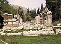
The first and smallest Roman temple was built in the 1st century AD. As one enters the gate at the edge of the village into the archeological park that is maintained by the Department of Antiquities, the Lower Small Temple appears first and directly ahead to the right of the creek. The temple was dedicated to the Syro-Phoenician mermaid goddess Atargatis and her consort, the god Hadaranes.[5] Hadaranes is the local name of Hadad, the god of thunder, lightning and rain. Atargatis is the goddess of fertility. A small water channel runs through the podium of the temple leading to the belief that water purification rituals were conducted at the temple. The entrance of the temple faces south; it consists of a stairway leading to a portico with four columns with Ionic-style capitals. The cella, or central space of the temple, is accessed through three doors at the top of the stairway, and the restricted adytum is accessed by a stairway of nine steps at the end of the cella. The statue of the god or goddess was located inside the adytum and was usually not accessible to the public. In addition to the water channel running through and around the podium, there is also a smaller water channel that runs from the base of the statue of the god or goddess in the adytum down to the center of the cella. In the remains of this temple, archaeologists discovered a stone with an inscription mentioning a “female virgin prophet” named Hochmea. Hochmea was the priestess of Hadaranes and Atargatis; she dedicated herself to those two gods and cut herself off from the world. The stone inscription says: "According to an order from the god, she stopped eating bread for 20 years and lived for 100 years." This stone was removed by archaeologists and is no longer located at the temple site. This small temple was apparently used for the public cult, which allowed everyone to participate in purification rituals.[6]

Opposite the creek lies the Great Temple which was extensively restored by the government of Lebanon in the 1950s. Towering nearly 20 m (66 ft), the temple was built during the 2nd and 3rd centuries AD and was apparently used for a mysterious cult that spread during that era, similar to the temple of
, as well as to a young god who played the role of their son. The entrance of the temple faces east; it is built over a large podium and accessed through a three-part stairway leading to a portico with four columns with Corinthian-style capitals. To the left of the stairway, a carved relief depicts a priest with two icons on his chest, representing a god and a goddess. He is wearing a hat with a crescent carved on it, and he holds a floral water sprinkler in his left hand and a cup in his right hand, which pours holy water onto a small altar.The
The inside of the Great Temple consists of two parts: the cella, where the people used to gather, and the elevated adytum, which was accessed by a stairway. The adytum used to hold the statue of the god or goddess. Under the elevated adytum is a crypt, which held the items used during the ceremonies and rituals of the temple. The doorway leading to the crypt is decorated with a carved relief representing a priest pouring holy water over an altar. Next to him, a woman holds an undefined object in her right hand. To the left, the relief represents a winged boy riding over a sheep or a bull.
The Small Temple of Niha is oriented north–south, while the Great Temple is oriented east–west. During the excavations of the site, an oratory was discovered in front of the Small Temple. The oratory had an altar representing the goddess of Niha, surrounded by a number of steles sculpted in the local style (not Roman style). The reason for the perpendicular orientation of the two temples is the presence of this monumental altar, which was situated in front of the Small Temple, and which was used as a base for the orientation of the Great Temple.
Two other Upper Roman temples were constructed at the Hosn, approximately 2 km away from the two temples mentioned earlier. Located at an elevation of 1,400 m (4,600 ft) with difficult road access, these two temples are not restored. Architectural evidence at the site indicates that it was transformed into a small fort during the medieval period (hence the name of Hosn). Built on a podium facing toward the east, the Upper Great Temple is composed of a portico with four columns, leading to a
Modern population
It is common in Lebanon that all voters return to their claimed village of ancestry for suffrage regardless of their place of residence in the country. The municipality of Niha states there are 1,260 registered voters in the village, and approximately 1,000 permanent residents in the village. Of the more than 2,000 individuals who claim Niha as their hometown but reside elsewhere, nearly 400 reside outside Lebanon. The summer population swells considerably as vacationers with family ties to the village flock to the village from the Lebanese coastline or abroad (including the
Until the 1960s, the population dressed in traditional Lebanese costumes, notably the male As the population modernized and education became widespread, western dresses became the norm. Traditional dresses are only worn today during celebratory festivities.
The primary economic engine of the village is agriculture. The village produce includes grapes, apples, cherries, almonds, that are then transported to
Whereas illiteracy was common at the beginning of the 20th century, the literacy rate today is very high, and likely higher than the average literacy rate in Lebanon. The village is home to a secondary education school ( ثانوية نيحا) and boasts a high concentration of college graduates including medical doctors, engineers, scientists and teachers.
Musical events
The village municipality along with the Ministry of Tourism sponsor the annual International Festival of Music in Niha,[8] covering classical Western and Arabic music.
Niha Gallery
-
 Roman temple of Hosn Niha, Lebanon
 -
 Roman temple of Hosn Niha, Lebanon
 -
 Roman temple of Hosn Niha, Lebanon
 -
 Roman temple atNiha, Lebanon
 -
 Statue at the Roman temple at Niha, Lebanon
 -
 Small lower temple at Niha, Lebanon


References
- ^ "Niha (Zahleh)". Localiban. 2008-02-13. Retrieved 2013-02-02.
- ^ "Archived copy" (PDF). Archived from the original (PDF) on 2012-09-15. Retrieved 2009-11-12.
{{cite web}}: CS1 maint: archived copy as title (link) - ^ "Press Releases 2009 | Embassy of the United States Beirut, Lebanon". Lebanon.usembassy.gov. 2009-04-27. Archived from the original on 2013-02-17. Retrieved 2013-02-02.
- ^ Khalife, Issam (2004). The Districts of Lebanon in The 16th Century (in Arabic). p. 125.
- ^ The Roman Near East: 31 BC-AD 337 (Carl Newell Jackson Lectures) Harvard University Press (March 15, 1995) p. 282
- ^ "Discover Lebanon Guide, Itinerary 12-E Niha" (PDF). Lebanon Ministry of Tourism. [permanent dead link]
- ^ "Origin of Levantine Costumes". Almashriq.hiof.no. Retrieved 2013-02-02.
- ^ see for example http://www.resonnance.org/pdf/affiche_4concerti_liban_2009.pdf Archived 2011-07-27 at the Wayback Machine
Bibliography
- Warren, C.; Conder, C.R. (1884). The Survey of Western Palestine: Jerusalem. London: Committee of the Palestine Exploration Fund. (pp. 502-503)
External links

Capital: Zahlé | ||
| Towns and villages |
|  |
| Other | ||
| International | |
|---|---|
| National | |