
Nilgiri Mountains
| Nilgiri Mountains | |
|---|---|
mya | |
| Mountain type | Fault[1] |
| Climbing | |
| Easiest route | NH 67 (Satellite view) or Nilgiri Mountain Railway |
The Nilgiri Mountains form part of the Western Ghats in northwestern Tamil Nadu, Southern Karnataka, and eastern Kerala in India. They are located at the trijunction of three states and connect the Western Ghats with the Eastern Ghats. At least 24 of the Nilgiri Mountains' peaks are above 2,000 metres (6,600 ft), the highest peak being Doddabetta, at 2,637 metres (8,652 ft).
Etymology
The word Nilgiri, comes from Tamil words neelam (blue) + giri (mountain), has been in use since at least 1117 CE. In Tamil literature it is mentioned as Iraniyamuttam
Location
The Nilgiri Hills are separated from the
Three national parks border portions of the Nilgiri mountains. Mudumalai National Park lies in the northern part of the range where Kerala, Karnataka, and Tamil Nadu meet, covering an area of 321 km2 (124 sq mi). Mukurthi National Park lies in the southwest part of the range, in Kerala, covering an area of 78.5 km2 (30.3 sq mi), which includes intact shola-grassland mosaic, habitat for the Nilgiri tahr. Silent Valley National Park lies just to the south and contiguous with those two parks, covering an area of 89.52 km2 (34.56 sq mi).[citation needed]
Conservation
The Nilgiri Hills are part of the Nilgiri Biosphere Reserve (itself part of the UNESCO World Network of Biosphere Reserves.[6]), and form a part of the protected bio-reserves in India.

.jpg)

History
The high steppes of the Nilgiri Hills have been inhabited since
The first recorded use of the word Nila applied to this region can be traced back to 1117 CE. In the report of a general of
A
In 1814, as part of the Great Trigonometrical Survey, a sub-assistant named Keys and an apprentice named McMahon ascended the hills by the Danaynkeucottah (Dannayakana Kote) Pass, penetrated into the remotest parts, made plans, and sent in reports of their discoveries. As a result of these accounts, Messrs. Whish and Kindersley, two young Madras civilians, ventured up in pursuit of some criminals taking refuge in the mountains, and proceeded to observe the interior. They soon saw and felt enough favorable climate and terrain to excite their own curiosity, and that of others.[11]

After the early 1820s, the hills were developed rapidly under the British Raj, because most of the land was already privately owned by British citizens. It was a popular summer and weekend getaway for the British during the colonial days. In 1827, Ooty became the official sanatorium and the summer capital of the Madras Presidency. Many winding hill roads were built. In 1899, the Nilgiri Mountain Railway was completed by influential and enterprising British citizens, with venture capital from the Madras government.[12][13]
In the 19th century, when the British
Peaks in the Nilgiris


The highest point in the Nilgiris and the southern extent of the range is
Closely linked peaks in the west of Doddabetta range and nearby Udhagamandalam include:[citation needed]
- Kolaribetta: height: 2,630 metres (8,629 ft)
- Makurni: 2,594 metres (8,510 ft)
- Hecuba: 2,375 metres (7,792 ft)
- Kattadadu: 2,418 metres (7,933 ft)
- Kulkudi: 2,439 metres (8,002 ft)
Snowdon (height: (2,530 metres (8,301 ft)) 11°26′N 76°46′E / 11.433°N 76.767°E is the northern extent of the range. Club Hill (2,448 metres (8,031 ft)) and Elk Hill (2,466 metres (8,091 ft)) 11°23′55″N 76°42′39″E / 11.39861°N 76.71083°E are significant elevations in this range. Snowdon, Club Hill and Elk Hill with Doddabetta, form the impressive Udhagamandalam Valley.
Devashola (height: 2,261 metres (7,418 ft)), notable for its blue gum trees, is in the south of Doddabetta range.
Kulakombai (1,707 metres (5,600 ft)) is east of the Devashola. The Bhavani Valley and the Lambton's peak range of Coimbatore district stretch from here.
Muttunadu Betta (height: 2,323 metres (7,621 ft)) 11°27′N 76°43′E / 11.450°N 76.717°E is about 5 km, north northwest of Udhagamandalam. Tamrabetta (Coppery Hill) (height: 2,120 metres (6,955 ft)) 11°22′N 76°48′E / 11.367°N 76.800°E is about 8 km southeast of Udhagamandalam. Vellangiri (Silvery Hill) (2,120 metres (6,955 ft)) is 16 km west-northwest of Udhagamandalam.[16]
Waterfalls

The highest waterfall, Kullakamby Fall, north of Kolakambai hill, has an unbroken fall of 400 ft (120 m). Nearby is the 150 ft (46 m) Halashana falls. The second highest is
Flora and fauna

Over 2,800 species of flowering plants, 160 species of

The dominant type of habitat is
- Vulnerable species: Miliusa nilagirica, Nothapodytes foetida, Commelina wightii
- Rare species: Ceropegia decaisneana Ceropegia pusilla, Senecio kundaicus
- Endangered species: Youngia nilgiriensis, Impatiens neo-barnesii, Impatiens nilagirica, Euonymus angulatus and Euonymus serratifolius.[22]
-
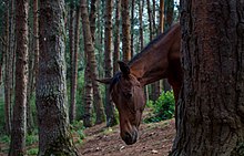 Wild horse in pine forest
 -
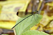 endemicto Nilgiri
 -
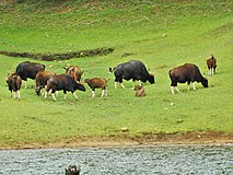 Herd of Gaur, Indian bisons in Mudumalai national park


_at_Periyar_National_Park_%26_Wildlife_Sanctuary.jpg)
References
- ^ "Application of GPS and GIS for the detailed Development planning". Map India 2000. 10 April 2000. Archived from the original on 3 June 2008. Retrieved 5 June 2011.
- ^ The Missionary Herald of the Baptist Missionary Society. Baptist Mission House. 1886. p. 398.
- ISBN 9783515026406.
- ^ "Decline of a Montane Ecosystem". Kartik Shanker Centre for Ecological Sciences, Indian Institute of Science. February 1997.
- ^ "Nilgiri Hills". Encyclopædia Britannica. Retrieved 25 April 2019.
- ^ UNESCO, World Heritage sites, Tentative lists, Western Ghats (subcluster nomination), retrieved 4/20/2007 World Heritage sites, Nilgiri Sub-Cluster
- ^ "Collection search: You searched for Nilgiri". British Museum. Retrieved 9 August 2016.
- ^ Pai, Mohan (15 January 2009). ...and they created little England. the-western-ghats-by-mohan-pai-hill-stations, Egmore, Chennai. pp. Ootacamund.
{{cite book}}:|work=ignored (help) - ^ a b "Kannada script (10600)". Department of Archaeology - Tamil Nadu. Tamil Nadu Government. Archived from the original on 1 March 2017. Retrieved 25 April 2016.
- ISBN 978-81-2060-546-6.
- ^ Burton, Richard Francis (1851). "Nilgiri Hills (India), Description and travel; Nilgiri Hills (India), Social life and customs". Goa, and the Blue Mountains, or, Six months of sick leave. London: R. Bentley.
- ^ "Ooty Queen of hill stations". www.ooty.com. Retrieved 5 June 2011.
- ^ "Nilgiri Mountain Railway". railtourismindia.com. Retrieved 8 March 2013.
- ^ Sarat Chandra Roy (Rai Bahadur), ed. (1959). Man in India, Volume 39. A. K. Bose. p. 309. Retrieved 2 March 2012.
d: Tamil-Chinese Crosses in the Nilgiris, Madras. S. S. Sarkar* (Received on 21 September 1959) During May 1959, while working on the blood groups of the Kotas of the Nilgiri Hills in the village of Kokal in Gudalur, inquiries were made regarding the present position of the Tamil-Chinese cross described by Thurston (1909). It may be recalled here that Thurston reported the above cross resulting from the union of some Chinese convicts, deported from the Straits Settlement, and local Tamil Paraiyan
- ISBN 0-89577-087-3.
- ^ District Administration, Nilgiris (8/20/2007) National Informatics Centre, Nilgiris, retrieved 8/31/2007 Hills and Peaks
- ^ Eagan, J. S. C (1916). The Nilgiri Guide And Directory. Vepery: S.P.C.K. Press.
- ^ The District Collector, Collector's Office, Udhagamandalam, The Nilgiris District, Tamil Nadu, General Information, Rare Trees, Fruits, Flowers & Animals retrieved 9/2/2007.
- ^ Davidar, E. R. C. 1978. Distribution and status of the Nilgiri tahr (Hemitragus hylocrius) 1975-1978. Journal of the Bombay Natural History Society; 75: 815-844.
- ^ Rice, C G Dr (1984) US Fish and Wildlife Service, Washington, USA, "The behaviour and ecology of Nilgiri Tahr", Tahr Foundation, retrieved 4/17/2007. Archived 28 September 2006 at the Wayback Machine
- ^ Journal of the Bombay Natural History Society, 103 (2-3), May-Dec 2006 356-365 Habitat Modifications By Scotch Broom Cytisus scoparius Invasion of Grasslands of the Upper Nilgiris in India, Ashfaq Ahmed Zarr, Asad R. Rahmani, and Mark J. Behan Archived 19 December 2008 at the Wayback Machine
- ^ Nayar & Sastry (1987-88) Red Data Book, Plants of India Threatened Plants of Tamil Nadu
External links
 Media related to Nilgiri mountains at Wikimedia Commons