
Nkongsamba
This article needs additional citations for verification. (September 2014) |
Nikongsamba | |
|---|---|
City | |
Kupe-Manenguba | |
| Founded | 1917 |
| Elevation | 826 m (2,710 ft) |
| Population (2005) | |
| • Total | 104,050 (Census) |
Nkongsamba is a city in western
Mbo (Manenguba) is one of the languages used locally: in the surrounding district, Kaa and Baneka are used.[2]
Other places

Baré is a village about 10 kilometres (6.2 mi) from Ville. There is a weekly Thursday market at which farmers from the surrounding area gather to sell their goods.
Transport
Nkongsamba was the terminus of the 172-kilometre (107 mi) western railway line from the port of
airstrip
.
Notable natives
- Daniel Kamwa, actor and filmmaker
- Diederrick Joel, football player
- Samuel Eto'o, football player
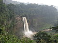
Gallery
-
 Mount Nllonako
 -
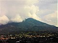
 Manengouba Massif from central market
 -
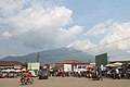
 Lele junction
 -
 Vallée de 2Kilo
 -
 Manengouba mount
 -
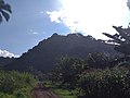 Manengouba massif
 -
 Nlonako Mount
 -
-
 Cattedrale dell'Immacolata a Nkongsamba
 -
 Le Ntsebe est une dance folklorique de la famille Bamougong de Nkongsamba.


See also
References
- ^ CELESTECOM, Cabinet. "Geographical Location". Nkongsamba City website. Retrieved 2023-05-24.
- ^ Bryan, Margaret Arminel, ed. (1959). The Bantu Languages of Africa. Oxford University Press. p. 4.

| International | |
|---|---|
| National | |
This Cameroon location article is a stub. You can help Wikipedia by expanding it. |