most developed states based on the Human Development Index, with every state with the exception of Maine above the national average.[10][11] It is also the most densely populated region in the United States, with 320 people per square mile (120 people/km2).[12][13]
The U.S. Census Bureau defines the Northeast United States as having a total area of 181,324 sq mi (469,630 km2), making it the smallest region of the United States by total area.
Anthropologists recognize the "Northeastern Woodlands" as one of the
Northeastern Woodlands", in addition to covering the entire Northeast U.S., also covered much of what is now Canada and others regions of what is now the eastern United States.[14]
Among the many tribes inhabiting this area were those that made up the Iroquois nations and the numerous Algonquian peoples.[15] In the United States of the 21st century, 18 federally recognized tribes reside in the Northeast.[16] For the most part, the people of the Northeastern Woodlands, on whose lands European fishermen began camping to dry their codfish in the early 1600s, lived in villages, especially after being influenced by agricultural traditions of the Ohio and Mississippi valley societies.[17]
Roger Williams, who was banished by Massachusetts for his beliefs in freedom of religion, and it was the first colony to guarantee all citizens freedom of worship.[21]Anne Hutchinson, who was also banished by Massachusetts, formed the town of Portsmouth.[21] Providence, Portsmouth and two other towns (Newport and Warwick) consolidated to form the Colony of Rhode Island and Providence Plantations.[21]
English colonial empire.[23] The territory became the colonies of New York and New Jersey.[23] New Jersey was originally split into East Jersey and West Jersey until the two were united as a royal colony in 1702.[23]
In 1681, William Penn, who wanted to give Quakers a land of religious freedom, founded Pennsylvania and extended freedom of religion to all citizens.[26]
Penn strongly desired access to the sea for the Province of Pennsylvania and leased what then came to be known as the "Lower Counties on the Delaware" from the Duke.[27] Penn established representative government and briefly combined his two possessions under one General Assembly in 1682.
By 1704, the Province of Pennsylvania had grown so large that their representatives wanted to make decisions without the assent of the Lower Counties and the two groups of representatives began meeting on their own, one at Philadelphia, and the other at New Castle, Delaware. Penn and his heirs remained proprietors of both and always appointed the same person Governor for their Province of Pennsylvania and their territory of the Lower Counties. The fact that Delaware and Pennsylvania shared the same governor was not unique. From 1703 to 1738, both New York and New Jersey shared a governor.[28] Massachusetts and New Hampshire also shared a governor for some time.[29]
The beginnings of the American Revolutionary War would be in the Northeast, specifically in Massachusetts. The Battles of Lexington and Concord in northeast of Boston would be the first military engagements between the Revolutionaries and the British.[30] Many of the major battles of the revolution would be fought in the Northeast. The British would evacuate Boston in early-1776 and would move to capture New York City.[31]
The revolutionaries were pushed to the Delaware River before suddenly moving forward against the British in the Battles of Trenton and Princeton.[31] A stalemate was reached in 1778, between the British and American Revolutionaries and continued until the end of the war in 1783.[32] The war would move to southern states and eventually conclude with the Battle of Yorktown in Virginia.[31]
Following the revolution the Northeast would see small skirmishes like the Whiskey Rebellion in western parts of Pennsylvania.[36] Many northeastern states would continue trading with the British and other European powers. Tensions between the United States and Europe (specifically Britain) would sour in the lead up to the War of 1812.
This caused certain trade merchants to
invasion of Canada and the occupation of Maine would be some of the major conflicts during the war.[38]
The war would end in 1815 and most of the Northeast has not seen any major conflict since then.
After the end of the War of 1812, industry boomed in the Northeast in the early and middle parts of the 19th century. With the construction of railroad and canals crossing the northeast and the rise of western territories and resources from the south, the Northeast experienced the development of new industries and a fast-growing population. Many of the coastal cities, including Boston, New York City, and Philadelphia, served as ocean trade ports for American goods.
By 1860, New York City, based on its present-day boundaries, was the first U.S. city to reach a population exceeding one million.[41] Due to the settlement of the Midwest and Great Plains, agriculture would collapse in the Mid-Atlantic and New England, with many farms being abandoned by the end of the century, returning to rural forest.
Conflicts with the south over the spread of slavery would become a large factor in the start of the American Civil War, between the United States (western and Northeastern states) and the Confederacy (southeastern states). The admission of Maine as a free state in exchange for Missouri becoming a slave state as part of the Missouri Compromise in 1820 would settle the final boundaries of the Northeastern states.[42]
The Mason-Dixon line would be established as the border of slavery, following the border of Pennsylvania and Delaware/Maryland.[43]Abolitionist movements would start in the Northeast and Midwest and would become prominent towards the mid-19th century, these groups advocated the shrinking or banning of slavery in the United States. Some Northeastern states still had small amounts of slaves into the 1850s, though some would ban it during the decade.
The election of 1860 led to the start of the Civil War; southern states succeeded from the United States in late-1860 and early-1861. States like Maryland and Delaware would remain in the union, even with slavery still legal. For the first two years, the eastern theater of the war would remain in Virginia and Maryland, but in 1863 the war would reach its northeastern most extent in Gettysburg, Pennsylvania. The Battle of Gettysburg is considered a turning point in the Civil War, seeing the end of the Confederate push northwards.[44]
While all Northeastern states would remain in the United States during the war, conflicts did arise, like the New York draft riots in 1863.[45] The war would end in 1865 with the United States taking back control of Southern states.
Industrial Revolution and modern times
Little Italy in Lower Manhattan, c. 1900Northeastern United States in 1908 from The Harmsworth atlas and Gazetter
Following the Civil War, the Northeast would see a large economic boom and would become one of the most industrialized regions in the world. Many technological innovation would be made in the Northeast during this time. The Second Industrial Revolution would see the northeast grow massively, even more so than before the Civil War. Many cities in the Northeast would explode in population, with cities like Philadelphia and New York climbing over one million people, while other cities like Buffalo, Boston, and Pittsburgh would rise above half a million during this time.
New York City eventually grew to become one of the largest cities in the world by 1900. With the American involvement in both World Wars, the Northeast would become a large base of war production, with the Brooklyn Naval Yard producing many navy ships.[46] Many worker strikes would occur in the states, including the Homestead strike in 1892.[47] Many of these cities would see a peak population and industrial output in the aftermath of World War II in the 1950s.[48]
Starting in the 1950s and continuing into the 21st century, a large industrial decline in the Northeast resulted in a depopulation of many Northeastern cities, many of which had not yet recovered from it into the 21st century. This led to the rise of programs of urban renewal and demolition of large parts of Northeastern cities during the mid and late 20th century.[49] There has also been a large population shift to the Sun Belt states starting in the 1960s.[50]
New York state lost its claim to being the most populated state after it was surpassed by California in the 1970s. Some Northeastern cities, including New York City, have recovered from its decline in the mid-20th century.[41] Many new information and service industries have risen in the northeast, which has led to a boom in the 21st century in some cities in the Northeast like Boston, New York, and Philadelphia. Some other cities like Hartford, Syracuse, and Buffalo still are declining though in the 21st century.[51]Hurricane Sandy would impact much of the northeast in 2012, severely damaging much of the coast and causing flooding inland. The hurricane would directly impact New Jersey and caused large amounts of flooding in New York City.[52]
Although the first settlers of New England were motivated by religion, since the 21st century,
Gallup survey, less than half of residents in Maine, Massachusetts, New Hampshire, and Vermont reported religion as an important part of their daily life.[53] In a 2010 Gallup survey, less than 30% of residents in Vermont, New Hampshire, Maine, and Massachusetts reported attending church weekly, giving them the lowest church attendance among U.S. states.[54]
The region is often subdivided into New England, the six states east of New York state and the Mid-Atlantic states of New Jersey, New York, and Pennsylvania. This definition has been essentially unchanged since 1880 and is widely used as a standard for data tabulation.[56][57][58][59]
The U.S. Census Bureau has acknowledged the obvious limitations of this definition and the potential merits of a proposal created after the 1950 census,[60] that would include changing regional boundaries to include Delaware, Maryland, and Washington, D.C. with the Mid-Atlantic states, but ultimately decided that "the new system did not win enough overall acceptance among data users to warrant adoption as an official new set of general-purpose State groupings. The previous development of many series of statistics, arranged and issued over long periods of time on the basis of the existing State groupings, favored the retention of the summary units of the current regions and divisions."[61] The U.S. Census Bureau confirmed in 1994 that it would continue to "review the components of the regions and divisions to ensure that they continue to represent the most useful combinations of states and state equivalents."[61]
Many organizations and reference works follow the Census Bureau's definition for the region.[62][63][64] In the history of the United States, the Mason–Dixon line between Pennsylvania (the North) and Maryland (the South) traditionally divided the regions,[65] but in modern times, various entities define the Northeastern United States in somewhat different ways.
The narrowest definitions include only the states of New England.[68] Other more restrictive definitions include New England and New York as part of the Northeast United States, but exclude Pennsylvania and New Jersey.[69][70]
States beyond the Census Bureau definition are included in Northeast Region by various other entities:
The National Park Service includes in their Northeast Region: Delaware, Maryland, West Virginia, and Virginia, though small parts are also in the National Capital Region.[80]
Topography
While most of the Northeastern United States lie in the physiographic region of the
As of 2012[update], forest-use covered approximately 60% of the Northeastern states, including Delaware, Maryland, and Washington, D.C., about twice the national average. About 11% was cropland and another 4% grassland pasture or range. There is also more urbanized land in the Northeast (12%) than any other region in the U.S.[75]
The climate of the Northeastern United States varies from northernmost state of
Bermuda High
pumps warm and sultry air toward the Northeast, and frequent (but brief) thundershowers are common on hot summer days.
In winter, the subtropical high retreats southeastward, and the polar jet stream moves south bringing colder air masses from up in Canada and more frequent storm systems to the region. Winter often brings both rain and snow as well as surges of both warm and cold air. In the southern part of the Northeast from coastal Rhode Island southwest to eastern Maryland, the Appalachians partially protect these locations from the extreme cold coming from the west and the interior of North America.[82]
The basic climate of the Northeast can be divided into a colder and snowier interior, including western Maryland, most of Pennsylvania, most of
Southern Connecticut, New York City, central and southern New Jersey, part of the Pennsylvania portion of the Delaware Valley including Philadelphia, Delaware, and most of Maryland. In the latter region the hardiness zone ranges from 7a to 8a. Annual mean temperatures range from the low-to-mid 50s F from Maryland to southern Connecticut, to the 40s F in most of New York State, New England, and northern Pennsylvania.[82][83][84]
Most of the Northeast has a humid continental climate (Dfa/Dfb/Dc). The northernmost portion of the humid subtropical zone (Cfa/Do) begins at Martha's Vineyard and extreme SW Rhode Island and extends southwestward down the coastal plain to central and southern Maryland. The oceanic climate zone (Cfb/Do) only exists on Block Island and Nantucket and is the only area of the Northeast where all months average between 0 and 22 °C (32 and 71.6 °F). Cape Cod borders this zone and warm-summer humid continental (Dfb/Dc).
U.S. population has been shifting away from the Northeast and Midwest toward the South and West.[87]
The region's racial composition as of 2020 was 64.42%
Latino of any race were 15.27% of the population.[88] There were 22,418,883 households and 14,189,719 families in 2021. Of the 22,418,883 households, 27.7% included children under the age of 18.[89]
In 2021, the region's the population's age distribution was 20.5% under age 18, 57.36% from 18 to 62, and 22.1% who were 62 years of age or older. The median age was 40.5 years. For every 100 females, there were 96.4 males. For every 100 women ages 18 and over, there were 94.3 men.[90]
The median income for a household in the region in 2021 was $77,142, and the median income for a family was $97,347. About 11.9% of the population were below the
poverty line, including 16.0% of those under age 18 and 10.4% of those age 65 or over.[91]
The two U.S. Census Bureau divisions in the Northeast,
9 divisions in population density according to the 2013 population estimate. The South Atlantic region (233.1) was very close behind New England (233.2). Due to the faster growth of the South Atlantic region, it will take over the #2 division rank in population density in the next estimate, dropping New England to 3rd position. New England is projected to retain the number 3 rank for many, many years, as the only other lower-ranked division with even half the population density of New England is the East North Central division (192.1) and this region's population is projected to grow slowly. [d][92]
New York City, New York is the most populated city in both the Northeast and the United States. Its population was 8,804,190 in 2020. Its metro area has a population of 20,140,470.[93]
Philadelphia, Pennsylvania is the second-most populated in the Northeast and sixth-largest in the nation. Its population was 1,603,797 in 2020. Its metro area population was 6,228,601.
Boston, Massachusetts is the third-largest city in the Northeast and 24th-largest in the nation. Its population was 675,647 in 2020. Its metro area had a population of 4,941,632.
Newark, New Jersey is the fourth-largest city in the Northeast and 66th-largest in the U.S. Its population was 311,549 in 2020. Its metro area is combined with the New York area.
Pittsburgh, Pennsylvania is the fifth-largest city in the Northeast and 68th-largest in the nation. Pittsburgh is at the western frontier of the Northeast, a short drive from the Ohio border, and is widely regarded as the transition point between the Northeast and Midwest. Its population was 302,971 in 2020. Its metro area has a population of 2,370,930.
Jersey City, New Jersey is the sixth-largest city in the Northeast and 75th-largest in the nation. It had a population of 292,449 in 2020. It sits directly across the Hudson River from New York City.
metro area
had a population of 1,166,902.
Yonkers, New York is the eighth-largest city in the Northeast and 111th-largest city in the U.S. It had a population of 211,569 in 2020. It borders the Bronx, a borough of New York City to its south.
Rochester, New York is the ninth-largest city in the Northeast and the 112th-largest city in the United States. It had a population of 211,328 in 2020. The Rochester metro has a population of 1,090,135.
Worcester, Massachusetts is the tenth-largest city in the Northeast and the 114th-largest city in the United States. It had a population of 206,518 in the 2020 census. It is an edge city of Greater Boston and its metro is combined with it.
Economy
This section needs expansion. You can help by adding to it. (February 2023)
As of 2012[update], the Northeast U.S. accounts for approximately 23% of the nation's
Rural regions and states, including most of Upstate New York, Vermont, New Hampshire, and Maine, rely more on agriculture, logging, mining, and tourism to help boost their local and statewide economies. Many national and state parks in the region generate lots of tourism, especially during fall months. The logging industry is especially prominent in Maine, making up a large part of Northern Maine's economy.
Many Northeastern states have very large economies and are highly developed. As of 2022, the per capita gross domestic products for these states are:
30th Street Station in Philadelphia. Served by all SEPTA Regional Lines, Amtrak, NJ Transit's Atlantic City Line, it is the third-busiest Amtrak station and 11th-busiest train station in North America with over four million passengers in 2019.
, with over 10 million passengers in 2019, along with 27 million passengers from NJ Transit and 69 million from Long Island Rail in 2017.
Grand Central Terminal in New York City is served by Metro North and some Long Island Rail trains (beginning in January 2023). Grand Central Terminal had over 67 million annual passengers in 2017 and is the second-busiest train station in the nation and third-busiest in North America.
South Station in Boston is served by southern MBTA commuter lines and Amtrak, and was the seventh-busiest train station in North America with nearly 29 million passengers as of 2017.
North Station in Boston is served by northern MBTA commuter lines and the Downeaster on Amtrak. It had six million MBTA users in 2012 and 152,000 Amtrak passengers in 2021.
Delaware Memorial Bridge (I-295, NJ Turnpike) - Crosses the Delaware River between Delaware and New Jersey, the southern most fixed crossing on the river. Eastbound span opened in 1951, westbound span opened in 1968.
PATH Hudson Tubes - Carries the PATH metro trains underneath the Hudson River to connect Newark, Jersey City, and Hoboken to Lower and Midtown Manhattan. The tubes opened up in 1908/1909.
Holland Tunnel (I-78) - Crosses underneath the Hudson River, connects road traffic from Jersey City and Newark to Lower Manhattan. Opened in 1927.
Queens-Midtown Tunnel (I-495) - Crosses underneath the East River, connecting the Long Island Expressway to Manhattan. Opened in 1940.
Pennsylvania Station
and New England. Opened in 1910.
Lincoln Tunnel (NJ 495) - Crosses underneath the Hudson River to connect New Jersey to Midtown Manhattan. Opened in 1937.
Queensboro Bridge (NY 25) - Connects Midtown Manhattan to Long Island City. Opened in 1909.
Hell Gate Bridge (Amtrak) - Crosses the East River and Bronx Kill, provides a rail connection from Pennsylvania Station to the Bronx and Connecticut. Opened in 1917.
George Washington Bridge (I-95) - Crosses the Hudson River, connecting New York and New England to New Jersey and cross-country I-80. One of the busiest crossings in the United States. Double Decked. Opened in 1931.
Throgs Neck Bridge (I-295) Crosses the East River, connecting the Bronx and New England to the Queens and Long Island, northern most crossing of the East River. (no fixed crossings are in Long Island Sound) Opened in 1961.
Tappan Zee Bridge (I-87, I-287) - Crosses the Hudson River, carrying NY Thruway and suburban traffic from Rockland and Westchester counties. Alternative to GW Bridge. Current span opened in 2017, former span opened in 1955.
Newburgh-Beacon Bridge (I-84) - Crosses the Hudson River, carrying traffic from Pennsylvania and southeastern New York across the river to New England. Opened in 1963.
Q Bridge (I-95) - Crosses the Quinnipiac River, carrying New Haven traffic along with traffic heading to New England or New York. Current span opened in 2012, original span opened in 1958.
Baldwin Bridge (I-95) - Crosses the Connecticut River, carrying cross-state traffic and connecting Old Saybrook to New London. Opened in 1948.
The Rainbow Bridge, connecting New York to Canada nearby Niagara Falls.Bulkeley Bridge (I-84) - Crosses the Connecticut River, connecting Hartford area traffic across the river. The oldest interstate crossing in the US. Opened in 1908.
The Jersey City Terminal, a major rail and ferry connection between New Jersey and New York City.The Cross-Bronx Expressway (I-95) is an urban freeway which was built using slum clearance policies in the 1950s and 1960s. Today it is one of the most congested highways in the nation. It is regarded as a major cause for urban decay in the Bronx.[102]
Before European settlement, most of the Northeast was loosely connected by Native American trails, some of which would be incorporated into early-European settlement roads and turnpikes. One major early road was the Boston Post Road, connecting New York City and Boston along the Connecticut and Rhode Island coasts.[108] Later these roads would be included in the King's Highway, spanning most of the east coast. Smaller turnpikes would also connect cities across the northeast. These roads would prove essential to moving goods across the English colonies in the 18th century and would later play a large part in the American Revolution.[109]
The region saw a boom in canal-building in the early-19th century, with a major canal being the Erie Canal, opened in 1825, connecting the Great Lakes to the Hudson River and Atlantic Ocean through Western New York.[110] The first railroads would be built in the late-1820s and would explode in mileage in the mid to late 19th century.[111] Places like Philadelphia, New York, Boston, Newark, and Pittsburgh would become large water and rail hubs during the Industrial Revolution and would see tremendous booms in population and use.[112]
Many large rivers in the northeast like the Hudson and Delaware would be slowly crossed with bridges starting in the 1800s, with the first fixed crossing of the Hudson River south of Albany being the Poughkeepsie Railroad Bridge, opened in 1889.[113] The Delair Bridge, which would connect Philadelphia with New Jersey was opened six years later in 1896.[114] The first crossing of the Hudson River into New York City would be the series of Hudson River PATH tunnels, being opened in 1908 and 1909.[115] The first major vehicle tunnel would be the Holland Tunnel, opened up in 1927.[116]
The start of highway construction would be the
Lower Manhattan Expressway and the Inner Belt in Boston, which were not built due to fierce highway revolts and rising costs.[106][124][125]
After the major highway revolts and rise of environmental concerns, new highway and interstate projects were mostly cancelled or shortened in the Northeast by the 1990s.
Despite the lack of new major road projects in the Northeast, the region has still continued to grow in population, resulting in the rise of alternative forms of transport like HOV lanes or commuter rails. This has led to the Northeast having one of the highest transit usage percentages in North America, with the Long Island Railroad being the most used commuter rail in the continent.[126] One exception was the Big Dig, a major road project that would tear down the former elevated Central Artery (I-93) and instead tunnel it (and widen). It would also construct a new Charles River bridge and the Ted Williams Tunnel (I-90). This would end up becoming one of the costliest construction projects in the world, costing $21 billion adjusted to 2020 inflation.[127] The former highway's path would become the Rose Kennedy Greenway, a large public park. The Sheridan Expressway (former I-895) was also rebuilt into a boulevard in the late-2010s.[128]Rochester, New York has torn down the Inner Loop due to low traffic and to reunify neighborhoods in downtown and to create developable space.[129]
Culture
This section needs expansion. You can help by adding to it. (July 2021)
One geographer, Wilbur Zelinsky, asserts that the Northeast region lacks a unified cultural identity,[12] but has served as a "culture hearth" for the rest of the nation.[130] Several much smaller geographical regions within the Northeast have distinct cultural identities.[12]
Landmarks
Almost half of the National Historic Landmarks maintained by the National Park Service are located in the Northeastern United States.[131]
Religion
According to a 2009
Protestants and other Christian denominations. More than 20% of respondents in Maine, New Hampshire, and Vermont declared no religious identity.[132] Compared to other U.S. regions, the Northeast, along with the Pacific Northwest, has had the lowest regular religious service attendance and the fewest people for whom religion is an important part of their daily lives as of 2015.[133]
Sports
The Northeast region is home to numerous professional sports franchises in the "Big Four" leagues (NFL, NBA, NHL and MLB),[134] with more than 100 championships collectively among them.[135]
Gallup poll indicated that eight of the top ten Democratic states were located in the region, with every Northeastern state having a Democratic Party affiliation advantage of at least ten points.[137] The following table demonstrates Democratic support in the Northeast as compared to the remainder of the nation.[138]
Year
% President vote
% Senate seats
% House seats
Northeast
Remainder
Northeast
Remainder
Northeast
Remainder
2000
57.6
47.5
60.0
46.3
59.6
45.7
2002
60.0
45.0
58.3
44.7
2004
57.1
47.3
60.0
40.0
59.5
43.0
2006
75.0
45.0
73.8
48.3
2008
60.7
52.0
80.0
52.5
81.0
52.9
2010
75.0
47.5
67.9
38.5
The following table of United States presidential election results since 1920 illustrates that over the past seven presidential elections, only three Northeastern states supported a Republican candidate (New Hampshire voted for George W. Bush in 2000; Pennsylvania and Maine's 2nd congressional district voted for Donald Trump in 2016).[139] 2004 is so far the only election in U.S. history in which the winner did not win any northeastern state. Bolded entries indicate that party's candidate also won the general election.
The following table shows the breakdown of party affiliation of governors, attorneys general, state legislative houses and U.S. congressional delegation for the Northeastern states, as of May 2020[update]. (Demographics reflect registration-by-party figures from that state's registered voter statistics.)
Washington D.C. in the south and Boston in the north.[7][8][9]
Historically, the term has always connoted the Northeast.
^The U.S. Census Bureau reorganized its administrative units, and its regional offices do not cover the Census regions (the northeasternmost regional office headquartered in New York covers New England, New York, New Jersey, and Puerto Rico).[55]
from the original on May 15, 2016. Retrieved October 17, 2015. The most widely used regional definitions follow those of the U.S. Bureau of the Census.
from the original on December 15, 2019. Retrieved October 17, 2015. Perhaps the most widely used regional classification system is one developed by the U.S. Census Bureau.
from the original on January 26, 2021. Retrieved November 2, 2020. (M)ost demographic and food consumption data are presented in this four-region format.
^ ab"Six: Statistical Groupings of States and Counties". Geographic Areas Reference Manual(PDF). U.S. Census Bureau. November 1994. Archived(PDF) from the original on April 19, 2013. Retrieved July 31, 2013.
^Verne Thompson, ed. (2010). Encyclopedia of Associations: Regional, State, and Local Organizations: Northeastern States. Vol. (Vol. 2: Northeastern States) (22 ed.). Gale.
^"About The Council". Department of Defense Northeast Regional Council. Archived from the original on September 23, 2013. Retrieved September 21, 2013.
^ abDaniel P. Bigelow & Allison Borchers (2012). "Major Uses of Land in the United States"(PDF). USDA's Economic Research Service. Archived(PDF) from the original on November 29, 2021. Retrieved August 5, 2021.
^"Historical Election Results". U.S. National Archives and Records Administration. May 20, 2019. Archived from the original on July 30, 2017. Retrieved September 6, 2017.


.jpg)


.jpg)


 New York City, New York is the most populated city in both the Northeast and the United States. Its population was 8,804,190 in 2020. Its metro area has a population of 20,140,470.[93]
 Philadelphia, Pennsylvania is the second-most populated in the Northeast and sixth-largest in the nation. Its population was 1,603,797 in 2020. Its metro area population was 6,228,601.
 Boston, Massachusetts is the third-largest city in the Northeast and 24th-largest in the nation. Its population was 675,647 in 2020. Its metro area had a population of 4,941,632.
 Newark, New Jersey is the fourth-largest city in the Northeast and 66th-largest in the U.S. Its population was 311,549 in 2020. Its metro area is combined with the New York area.
 Pittsburgh, Pennsylvania is the fifth-largest city in the Northeast and 68th-largest in the nation. Pittsburgh is at the western frontier of the Northeast, a short drive from the Ohio border, and is widely regarded as the transition point between the Northeast and Midwest. Its population was 302,971 in 2020. Its metro area has a population of 2,370,930.
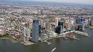 Jersey City, New Jersey is the sixth-largest city in the Northeast and 75th-largest in the nation. It had a population of 292,449 in 2020. It sits directly across the Hudson River from New York City.
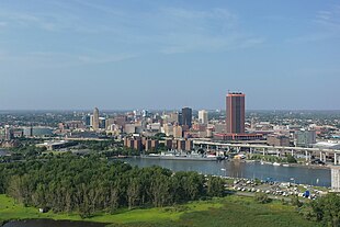 metro areahad a population of 1,166,902.
 Yonkers, New York is the eighth-largest city in the Northeast and 111th-largest city in the U.S. It had a population of 211,569 in 2020. It borders the Bronx, a borough of New York City to its south.
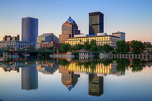 Rochester, New York is the ninth-largest city in the Northeast and the 112th-largest city in the United States. It had a population of 211,328 in 2020. The Rochester metro has a population of 1,090,135.
 Worcester, Massachusetts is the tenth-largest city in the Northeast and the 114th-largest city in the United States. It had a population of 206,518 in the 2020 census. It is an edge city of Greater Boston and its metro is combined with it.


_(cropped).jpg)


.jpg)


_crop.jpg)


