
Northern California
Northern California | |
|---|---|
| Largest city | San Jose |
| Population (2020) | |
| • Total | 15,775,319 |
Northern California (commonly shortened to NorCal) is a geographic and cultural region that generally comprises the northern portion of the U.S. state of
The
Evidence of Native American habitation in the area dates from at least 19,000 years ago[4] and successive waves of arrivals led to one of the most densely populated areas of pre-Columbian North America. The arrival of European explorers from the early 16th to the mid-18th centuries did not establish European settlements in northern California. In 1770, the Spanish mission at Monterey was the first European settlement in the area, followed by other missions along the coast—eventually extending as far north as Sonoma County.[5]
Description
.png)
Northern California is not a formal geographic designation. California's north–south midway division is around 37°N, near the level of Morgan Hill and Chowchilla. (The geographic center of California is at 37°09′58″N 119°26′58″W / 37.16611°N 119.44944°W near North Fork, northeast of Fresno.[6]) Popularly, though, "Northern California" usually refers to the state's northernmost 48 counties. Because of California's large size and diverse geography, the state can be subdivided in other ways as well. For example, the Central Valley is a region that is distinct both culturally and topographically from coastal California, though in northern versus southern California divisions, the Sacramento Valley and most of the San Joaquin Valley are usually placed in northern California. Some observers describe three partitions of California, with north and south sections separated by Central California.
The state is often considered as having an additional division north of the urban areas of the
The coastal area north of the Bay Area is often referred to as the North Coast — Mendocino, Lake, Humboldt, and Del Norte Counties (also potentially including Napa and Sonoma Counties). The interior region north of Sacramento metropolitan area is referred to by locals as the Northstate — roughly speaking, Butte, Colusa, Glenn, Lassen, Modoc, Plumas, Shasta, Sierra, Siskiyou, Tehama, and Trinity Counties.[7]
Northern California was used for the name of a proposed new state on the 2018 California ballot created by splitting the existing state into three parts.[8]
Significance
Since the events of the
Cities
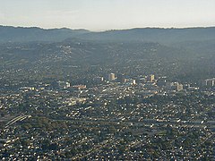
Northern California's largest
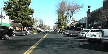
The state's larger inland cities are considered part of Northern California in cases when the state is divided into two parts. Key cities in the region which are not in major metropolitan areas include
-
 San Jose, the most populous city in Northern California and the San Francisco Bay Area, and the tenth largest city in the United States.
 -
 San Francisco, the second most populated city in Northern California and a major economic, cultural, and financial center for the region.
 -
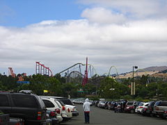
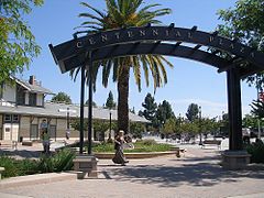
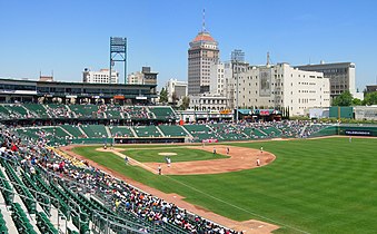 Fresno, the third most populated city in northern California, as seen from Chukchansi Park. Fresno is the largest city by population in the Central Valley.
 -
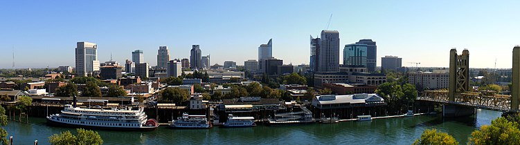 Sacramento, the fourth most populous city in Northern California, the capital city of the State of California, and the principal city of the Sacramento metropolitan area.
 -
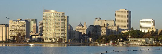
 Oakland, the fifth-largest city by population in Northern California. Oakland is the major port city of the region and the center of Northern California's African American community.


.jpg)

History
Prehistory to 1847
Inhabited for millennia by
European explorers
The first European to explore the coast was Juan Rodríguez Cabrillo, sailing for the Spanish Crown; in 1542, Cabrillo's expedition sailed perhaps as far north as the Rogue River in today's Oregon.[10] Beginning in 1565, the Spanish Manila galleons crossed the Pacific Ocean from Mexico to the Spanish Philippines, with silver and gemstones from Mexico. The Manila galleons returned across the northern Pacific, and reached North America usually off the coast of northern California, and then continued south with their Asian trade goods to Mexico.
In 1579, northern California was visited by the English explorer Sir Francis Drake who landed north of today's San Francisco and claimed the area for England. In 1602, the Spaniard Sebastián Vizcaíno explored California's coast as far north as Monterey Bay, where he went ashore. Other Spanish explorers sailed along the coast of northern California for the next 150 years, but no settlements were established.[11]
Spanish era
The first European inhabitants were Spanish missionaries, who built missions along the California coast. The mission at Monterey was first established in 1770, and at San Francisco in 1776. In all, ten missions stretched along the coast from Sonoma to Monterey (and still more missions to the southern tip of Baja California). In 1786, the French signaled their interest in the northern California area by sending a voyage of exploration to Monterey.
The first twenty years of the 19th century continued the colonization of the northern California coast by Spain. By 1820, Spanish influence extended inland approximately 25 to 50 miles (80 km) from the missions. Outside of this zone, perhaps 200,000 to 250,000 Native Americans continued to lead traditional lives. The
Russian presence
In 1812, the Russian state-sponsored
Mexican era
After
In 1825, the
American interest
American trappers began entering northern California in the 1830s.
Californian independence and beginning of the United States era
When the
Commodore

Gold Rush and California statehood
The
The Gold Rush also increased pressure to make California a
Population and agricultural expansion (1855–1899)

The decades following the Gold Rush brought dramatic expansion to northern California, both in population and economically – particularly in agriculture. The completion of the
Substantial tensions during this era included nativist sentiments (primarily against Chinese immigrants),[21] tensions between the increasing power of the Southern Pacific Railroad and small farmers, and the beginnings of the labor union movement.
Economy

Northern California's economy is noted for being the de facto world leader in high-tech industry (
Climate

Northern California has a warm or mild to cool climate, in which the Sierra mountains gets snow in the late fall through winter and occasionally into spring. Summers are mild along the coast and generally warm and dry, while winters are cool and usually wet. The high temperatures range from 50s to 30s in the winters while summers temperature range is 90s to 60s or 50s, with highs well into the 100s for the Sacramento region. Snow covers the mountains (generally above 3000 feet) in mid January through February. Fog occurs infrequently or occurs normally in the west and coast, especially in the summer, creating some of the coolest summer conditions in North America.[22] Since the first decade of the 21st century, droughts and wildfires have increased in frequency as a consequence of climate change.[23][24]
Population
| Census | Pop. | Note | %± |
|---|---|---|---|
| 1850 | 86,105 | — | |
| 1860 | 346,714 | 302.7% | |
| 1870 | 516,089 | 48.9% | |
| 1880 | 772,778 | 49.7% | |
| 1890 | 961,628 | 24.4% | |
| 1900 | 1,147,725 | 19.4% | |
| 1910 | 1,569,141 | 36.7% | |
| 1920 | 2,003,075 | 27.7% | |
| 1930 | 2,632,273 | 31.4% | |
| 1940 | 3,066,654 | 16.5% | |
| 1950 | 4,654,248 | 51.8% | |
| 1960 | 6,318,482 | 35.8% | |
| 1970 | 7,849,575 | 24.2% | |
| 1980 | 9,359,160 | 19.2% | |
| 1990 | 11,490,926 | 22.8% | |
| 2000 | 13,234,136 | 15.2% | |
| 2010 | 14,573,946 | 10.1% | |
| 2020 | 15,775,319 | 8.2% |
The population of the forty-eight counties of northern California has shown a steady increase over the years.[25][26]
The largest percentage increase outside the Gold Rush era (52%) came during the 1940s, as the region was the destination of many post-War veterans and their families, attracted by the greatly expanding industrial base and (often) by their time stationed in northern California during World War II. The largest absolute increase occurred during the 1980s (over 2.1 million person increase), attracted by job opportunities in part by the expansion taking place in Silicon Valley and the Cold War–era expansion of the defense industry. Since the 2000 U.S. Census, Northern California has grown at a faster rate than Southern California due to the strong economic performances of the Bay Area and Sacramento.[27]

Parks and other protected areas
National Park System
The U.S.
National Monuments and other federally protected areas
Other areas under federal protection include
In addition, the California Coastal National Monument protects all islets, reefs, and rock outcroppings from the shore of northern California out to a distance of 12 nmi (22 km), along the entire northern California coastline. In addition, the National Park Service administers protected areas on Alcatraz Island, the Golden Gate National Recreation Area, Whiskeytown–Shasta–Trinity National Recreation Area, and the Smith River National Recreation Area. The NPS also administers the Manzanar National Historic Site in Inyo County, the Rosie the Riveter World War II Home Front National Historical Park in Richmond, and the Tule Lake National Monument outside of Tulelake.
Other
- Tilden Regional Park
- Alum Rock Park
- Angel Island
- Bidwell Park
- Big Basin Redwoods State Park
- Butano State Park
- Calaveras Big Trees State Park
- Castle Rock State Park
- Caswell Memorial State Park
- East Bay Regional Park District
- Farallon Islands
- Golden Gate Park
- Henry W. Coe State Park
- Humboldt Redwoods State Park
- Jedediah Smith Redwoods State Park
- Lake Tahoe Basin
- Marble Mountain Wilderness
- Mill Creek State Park
- Mount Tamalpais State Park
- Suisun Marsh
- Sacramento River
- Talowa Dunes State Park
- Turtle Bay Exploration Park
- McArthur–Burney Falls Memorial State Park
- Wilder Ranch State Park
- Sequoia National Park
Educational institutions
Northern California hosts a number of world-renowned universities including
Public
- Six University of California campuses:
- UC Berkeley
- UC Davis
- UC Hastings
- UC Merced
- UC San Francisco
- UC Santa Cruz
- Eleven California State University campuses:
- California Maritime Academy
- Chico State
- CSU East Bay
- CSU Monterey Bay
- Fresno State
- Cal Poly Humboldt
- Sacramento State
- San Francisco State
- San Jose State
- Sonoma State
- Stanislaus State
- A large number of local community colleges
Private
(Partial list)
- Academy of Art University
- California College of the Arts
- Dominican University of California
- Fresno Pacific University
- Golden Gate University
- Jessup University
- Menlo College
- Northwestern Polytechnic University
- Notre Dame de Namur University
- Pacific Union College
- Samuel Merritt University
- Santa Clara University
- Saint Mary's College of California
- Simpson University
- Stanford University
- Touro University California
- University of San Francisco
- University of the Pacific
Research
(Partial list)
- American Institute of Mathematics
- Bodega Marine Reserve
- Hopkins Marine Station
- Joint Genome Institute
- Lawrence Berkeley National Laboratory
- Lawrence Livermore National Laboratory
- Lick Observatory
- Long Marine Laboratory
- Mathematical Sciences Research Institute
- Monterey Bay Aquarium Research Institute
- NASA Ames Research Center
- Owens Valley Radio Observatory
- Pacific Institute
- Point Reyes Bird Observatory
- White Mountain Research Station
Counties
- Alameda
- Alpine
- Amador
- Butte
- Calaveras
- Colusa
- Contra Costa
- Del Norte
- El Dorado
- Fresno
- Glenn
- Humboldt
- Inyo
- Kings
- Lake
- Lassen
- Madera
- Marin
- Mariposa
- Mendocino
- Merced
- Modoc
- Mono
- Monterey
- Napa
- Nevada
- Placer
- Plumas
- Sacramento
- San Benito
- San Francisco
- San Joaquin
- San Mateo
- Santa Clara
- Santa Cruz
- Shasta
- Sierra
- Siskiyou
- Solano
- Sonoma
- Stanislaus
- Sutter
- Tehama
- Trinity
- Tulare
- Tuolumne
- Yolo
- Yuba
Regions
The following regions are entirely or partly within northern California:
- Big Sur
- Cascade Range
- Central California
- Central Coast
- Central Valley
- Coastal California
- East Bay (SF)
- Eastern California
- Emerald Triangle
- Gold Country
- Greater Sacramento
- Klamath Basin
- Lake Tahoe
- Lassen Peak
- Lost Coast
- Metropolitan Fresno
- Mount Shasta
- North Bay (SF)
- North Coast
- Russian River
- Sacramento Valley
- San Francisco Bay Area
- San Francisco Peninsula
- San Joaquin Valley
- Santa Clara Valley
- Shasta Cascade
- Sierra Nevada
- Silicon Valley
- South Bay (SF)
- Telecom Valley
- Tri-Valley
- Trinity Alps
- Wine Country
- Yosemite
- Yuba–Sutter area
Cities and towns with more than 50,000 inhabitants
- Largest cities (city proper) in northern California
-
 1 – San Jose
 -
 2 –San Francisco
 -
 3 – Fresno
 -
 4 – Sacramento
 -
 5 – Oakland
 -
 6 – Stockton
 -
 7 – Fremont
 -
 8 – Modesto
 -
 9 – Santa Rosa
 -
 10 – Elk Grove
 -
 11 – Salinas
 -
 12 – Hayward
 -
 13 – Sunnyvale
 -
 14 – Roseville
 -
 15 – Visalia
 -
 16 – Santa Clara
 -
 17 – Vallejo
 -
 18 – Concord
 -
 19 – Berkeley
 -
 20 – Clovis
 -
 21 – Fairfield
 -
 22 – Richmond
 -
 23 – Antioch
 -
 24 – San Mateo
 -
 25 – Daly City
 -
 26 – Vacaville
 -
 27 – Chico
 -
 28 – Redding
 -
 29 – Tracy
 -
 30 – San Leandro
 -
 31 – Livermore
 -
 32 – Citrus Heights
 -
 33 – Merced
 -
 34 – San Ramon
 -
 35 – Redwood City
 -
 36 – Manteca
 -
 37 – Mountain View
 -
 38 – Folsom
 -
 39 – Milpitas
 -
 40 – Pleasanton


_Dec_2009.jpg)


.JPG)


.JPG)

| City | Population (2020)[28] |
|---|---|
| Alameda | 78,280 |
| Antioch | 115,291 |
| Berkeley | 124,321 |
| Brentwood | 64,292 |
| Chico | 101,475 |
| Citrus Heights | 87,583 |
| Clovis | 120,124 |
| Concord | 125,410 |
| Cupertino | 60,381 |
| Daly City | 104,901 |
| Davis | 66,850 |
| Dublin | 72,589 |
| Elk Grove | 176,124 |
| Fairfield | 119,881 |
| Folsom | 80,454 |
| Fresno | 542,107 |
| Fremont | 230,504 |
| Gilroy | 59,520 |
| Hanford | 57,990 |
| Hayward | 162,954 |
| Livermore | 87,955 |
| Lodi | 66,348 |
| Madera | 66,224 |
| Manteca | 83,498 |
| Merced | 86,333 |
| Milpitas | 80,273 |
| Modesto | 218,464 |
| Mountain View | 82,376 |
| Napa | 79,246 |
| Novato | 53,225 |
| Oakland | 440,646 |
| Palo Alto | 68,572 |
| Petaluma | 59,776 |
| Pittsburg | 76,416 |
| Pleasanton | 79,871 |
| Porterville | 62,623 |
| Rancho Cordova | 79,332 |
| Redding | 93,611 |
| Redwood City | 84,292 |
| Richmond | 116,448 |
| Rocklin | 71,601 |
| Roseville | 147,773 |
| Sacramento | 524,943 |
| Salinas | 163,542 |
San Francisco
|
873,965 |
| San Jose | 1,013,240 |
| San Leandro | 91,008 |
| San Mateo | 105,661 |
| San Rafael | 61,271 |
| San Ramon | 84,605 |
| Santa Clara | 127,647 |
| Santa Cruz | 62,956 |
| Santa Rosa | 178,127 |
| South San Francisco | 66,105 |
| Stockton | 320,804 |
| Sunnyvale | 155,805 |
| Tracy | 93,000 |
| Tulare | 68,875 |
| Turlock | 72,740 |
| Union City | 70,143 |
| Vacaville | 102,386 |
| Vallejo | 126,090 |
| Visalia | 141,384 |
| Walnut Creek | 70,127 |
| Watsonville | 52,590 |
| West Sacramento | 53,915 |
| Woodland | 61,032 |
| Yuba City | 70,117 |
Metropolitan areas
Northern California is home to three of the state's four
| Metropolitan region | Population |
|---|---|
| San Francisco Bay Area | 7,468,390 |
Greater Sacramento
|
2,461,780 |
| Metropolitan Fresno | 1,081,315 |
Major business districts
The following are major central business districts:
Transportation
See also articles:
See also categories:
- Transportation in Alameda County
- Transportation in Alpine County
- Transportation in Amador County
- Transportation in Butte County
- Transportation in Calaveras County
- Transportation in Colusa County
- Transportation in Contra Costa County
- Transportation in Del Norte County
- Transportation in El Dorado County
- Transportation in Fresno County
- Transportation in Glenn County
- Transportation in Humboldt County
- Transportation in Inyo County
- Transportation in Kings County
- Transportation in Lake County
- Transportation in Lassen County
- Transportation in Madera County
- Transportation in Marin County
- Transportation in Mariposa County
- Transportation in Mendocino County
- Transportation in Merced County
- Transportation in Modoc County
- Transportation in Mono County
- Transportation in Monterey County
- Transportation in Napa County
- Transportation in Nevada County
- Transportation in Oakland
- Transportation in Placer County
- Transportation in Plumas County
- Transportation in Sacramento
- Transportation in Sacramento County
- Transportation in San Benito County
- Transportation in the San Francisco Bay Area
- Transportation in San Francisco
- Transportation in San Joaquin County
- Transportation in San Mateo County
- Transportation in Santa Clara County
- Transportation in Santa Cruz County
- Transportation in Shasta County
- Transportation in Sierra County
- Transportation in Siskiyou County
- Transportation in Solano County
- Transportation in Sonoma County
- Transportation in Stanislaus County
- Transportation in Sutter County
- Transportation in Tehama County
- Transportation in Trinity County
- Transportation in Tulare County
- Transportation in Tuolumne County
- Transportation in Yolo County
- Transportation in Yuba County
Airports

_(2).jpg)
There are 11 airports in Northern California categorized as Primary Service Commercial airports by the FAA:[31]
| Airport | ID | City | Category | 2018 Enplanements |
|---|---|---|---|---|
| San Francisco International Airport | SFO | San Francisco | Large Hub | 27,794,154 |
| San Jose International Airport | SJC | San Jose | Medium Hub | 7,037,144 |
| Oakland International Airport | OAK | Oakland | Medium Hub | 6,687,963 |
| Sacramento International Airport | SMF | Sacramento |
Medium Hub | 5,907,901 |
| Fresno Yosemite International Airport | FAT | Fresno |
Small Hub | 853,538 |
| Charles M. Schulz–Sonoma County Airport | STS | Santa Rosa | Non Hub | 217,994 |
| Monterey Regional Airport | MRY | Monterey | Non Hub | 188,046 |
| Stockton Metropolitan Airport | SCK | Stockton | Non Hub | 99,258 |
Arcata-Eureka Airport |
ACV | Arcata | Non Hub | 69,604 |
Redding Municipal Airport |
RDD | Redding | Non Hub | 42,775 |
| Mammoth Yosemite Airport | MMH | Mammoth Lakes | Non Hub | 23,522 |
Railroad
- Bay Area Rapid Transit (BART) – commuter subway connecting most of the core Bay Area including San Francisco, Oakland, and San Jose
- Caltrain – commuter rail between San Francisco and Gilroy (south of San Jose)
- Muni Metro (San Francisco)
- VTA light rail (San Jose)
- Altamont Corridor Express (ACE) – commuter train connecting Stockton and the Central Valley with San Jose and the Bay Area
- Sacramento Regional Transit District light rail
- Amtrak:
- California Zephyr – connects Chicago to the Bay Area
- Capitol Corridor – San Jose to Auburn (eastern suburb of Sacramento)
- Coast Starlight – coastal train between Los Angeles and Seattle with northern California stops in San Jose, Oakland, and Sacramento
- San Joaquin – Central Valley train linking Bakersfieldin the Central Valley to Sacramento and Oakland
Major transit organizations
- AC Transit
- Arcata and Mad River Transit System
- County Connection
- El Dorado Transit
- Eureka Transit Service
- Fairfield and Suisun Transit
- Fresno Area Express
- Golden Gate Transit
- Lake Transit
- Mendocino Transit Authority
- Monterey-Salinas Transit
- Porterville City Operated Local Transit
- Redwood Transit System
- SamTrans
- San Benito Express
- SF MUNI
- San Joaquin Regional Transit District
- Santa Clara Valley Transportation Authority (VTA)
- Santa Cruz Metro
- Solano Express
- SolTrans
- Sonoma County Transit
- Tri Delta Transit
- Visalia Transit
- VINE (Napa County)
Major transit ferries

- San Francisco Bay Ferry
- Golden Gate Ferry
- Blue & Gold Fleet
- Angel Island – Tiburon Ferry
Freeways
Interstate highways
 Interstate 80 (Eastshore Freeway/Lincoln Highway)
 Interstate 280 (Southern Embarcadero Freeway/Southern Freeway/Junipero Serra Freeway/Sinclair Freeway)
 Interstate 380
 Interstate 580 (Eastshore Freeway/MacArthur Freeway/Brown Freeway)
 Interstate 680 (Joseph P. Sinclair Freeway/Donald D. Doyle Highway/Blue Star Memorial Highway/Luther E. Gibson Freeway)
 Interstate 780
 Interstate 880 (Nimitz Freeway)
 Interstate 980 (Grove-Shafter Freeway)
- Interstate 238
 Interstate 5 (Golden State Freeway/West Side Freeway)
 Interstate 205 (Robert T. Monagan Freeway)
 Interstate 505
 Interstate 80 Business (Capital City Freeway)
U.S. Routes

 U.S. Route 6
 U.S. Route 50 (El Dorado Freeway)
 U.S. Route 101 (South Valley Freeway/Bayshore Freeway/James Lick Freeway/Central Freeway/Redwood Highway/Michael J. Burns Freeway/Redwood Highway)
 U.S. Route 395
 U.S. Route 97
 U.S. Route 199


Principal state highways
 State Route 1 (Pacific Coast Highway/Cabrillo Highway)
 State Route 3
 State Route 4
 State Route 9
 State Route 12
 State Route 13 (Ashby Avenue/Tunnel Road/Warren Freeway)
 State Route 16
 State Route 17
 State Route 20
 State Route 24
 State Route 25
 State Route 26
 State Route 29
 State Route 32
 State Route 33
 State Route 35 (Skyline Boulevard)
 State Route 36
 State Route 37 (Sears Point Tollway)
 State Route 41 (E.G. Lewis Highway, Yosemite Freeway, Southern Yosemite Highway, Wawona Road)
 State Route 43
 State Route 44
 State Route 49 (Golden Chain Highway)
 State Route 59
 /
/ /
/ State Route 61 (Webster Tube/Posey Tube/Doolittle Drive/Davis Street)
 State Route 63
 State Route 65
 State Route 68
 State Route 70
 State Route 82 (Monterey Highway/El Camino Real/Mission Street)
 State Route 84
 State Route 85 (Stevens Creek Freeway/West Valley Freeway/Norman Y. Mineta Highway/CHP Officer Scott M. Greenly Memorial Freeway)
 State Route 87 (Guadalupe Parkway)
 State Route 88
 State Route 89
 State Route 92 (J. Arthur Younger Freeway/Jackson Street)
 State Route 96
 State Route 99
 State Route 104
 State Route 108
 State Route 113
 State Route 116
 State Route 120
 State Route 121
 State Route 128
 State Route 130
 State Route 132
 State Route 137
 State Route 139
 State Route 140
 State Route 152
 State Route 156
 State Route 160 (North Sacramento Freeway/River Road)
 State Route 162
 State Route 165
 State Route 168
 State Route 174
 State Route 180
 /
/ State Route 185 (International Boulevard/East 14th Street/Mission Boulevard)
 State Route 190
 State Route 193
 State Route 198
 State Route 201
 State Route 216
 State Route 219
 State Route 236
 State Route 237
- State Route 238(Mission Boulevard, Foothill Boulevard)
 State Route 245
- State Route 254(Avenue of the Giants)
 State Route 262 (Mission Boulevard)
 State Route 267
 State Route 269
 State Route 275 (Tower Bridge Gateway)
 State Route 299
Communication
Telephone area codes
- ).
- ).
- Marin County. One of the three original Area Codesin California.
- ). Originally part of area code 415.
- Sutter County, Butte County, and Nevada County. Split from area code 916 in 1997–1998.
- 559 — Southern San Joaquin Valley (Madera, Fresno, and Visalia).
- 650 — San Francisco Peninsula (San Mateo, Redwood City, and Palo Alto). Originally part of area code 415.
- .
- 831 — Monterey, San Benito and Santa Cruz Counties. Originally part of area code 408.
- Sacramento suburbs in western Placer and El Dorado Counties. One of the three original area codes in California, formerly covered all areas now within 530.
- East Bay (Concord, Pittsburg, Walnut Creek, San Ramon, Pleasanton and Livermore). Originally part of area codes 415 and 510.[32]
Sports
Major league professional sports teams
| Sport | League | Team | Venue | City |
|---|---|---|---|---|
| Baseball | MLB | Oakland Athletics (American League) | RingCentral Coliseum
|
Oakland |
| San Francisco Giants (National League) | Oracle Park | San Francisco | ||
| Basketball | NBA | Golden State Warriors | Chase Center | San Francisco |
| Sacramento Kings | Golden 1 Center | Sacramento | ||
| Football | NFL | San Francisco 49ers | Levi's Stadium | Santa Clara |
| Ice hockey | NHL | San Jose Sharks | SAP Center
|
San Jose |
| Soccer | MLS | San Jose Earthquakes | Avaya Stadium
|
San Jose |
Indoor football
|
IFL | Bay Area Panthers | SAP Center | San Jose |
College sports teams
- California Golden Bears
- Cal Poly Humboldt Lumberjacks
- Stanford Cardinal
- Fresno State Bulldogs
- San Jose State Spartans
- Sacramento State Hornets
- UC Davis Aggies
Sports venues
- Laguna Seca Raceway(motorsport)
- Sonoma Raceway (motorsport)
- Olympic Club (golf)
- Silverado Country Club(golf)
- TPC Harding Park (golf)
- TPC Stonebrae (golf)
Sporting events
- Pac-12 Football Championship Game (college football)
- Emerald Bowl(college football)
- AT&T Pebble Beach Pro-Am (golf)
- Frys.com Open(golf)
- Swinging Skirts LPGA Classic (golf)
- Grand Prix of Sonoma (motorsport)
- Toyota/Save Mart 350 (motorsport)
- Monterey Sports Car Championships(motorsport)
- Superbike World Championship (motorsport)
See also
- Northern California Megaregion
- California megapolitan areas
- Central California
- History of California through 1899
- History of the west coast of North America
- Jefferson (proposed Pacific state)
- Megaregions of the United States
- Southern California
References
- ^ Morgan, Neil (April 19, 1963). "Westward Tilt: Northern California". Lodi News-Sentinel. Lodi, California. Retrieved September 7, 2014.
- ^ John E. Kent, ed. (1917). Kent Guide Manual (Harrison Narcotic Law) and Progressional Registry. San Francisco: The Service Press. p. 6.
- ^ San Francisco Planning and Urban Research Association. Retrieved November 21, 2009.
- ^ Sep 2019, Megan I. Gannon / 4 (September 4, 2019). "The Knotty Question of When Humans Made the Americas Home". SAPIENS. Retrieved July 29, 2021.
{{cite web}}: CS1 maint: numeric names: authors list (link) - ^ "Home | County of Sonoma". sonomacounty.ca.gov. Retrieved July 29, 2021.
- ^ O'Keefe, Rob (August 9, 2017). "Finding California's Geographic Center". Rediscovering the Golden State. Retrieved May 12, 2023.
- ^ Wiles, Tay (January 22, 2018). "A separatist state of mind". High Country News. Archived from the original on June 17, 2018. Retrieved August 23, 2018.
- ^ Myers, John (June 13, 2018). "Radical plan to split California into three states earns spot on November ballot". Los Angeles Times. Retrieved June 14, 2018.
- ^ R.F. Heizer (1966). "California Indian Tribes map". CaliforniaPrehistory.com. Archived from the original on April 30, 2011. Retrieved February 10, 2007.
- ^ "Juan Rodríguez Cabrillo: A Voyage of Discovery". U.S. National Park Service. Retrieved February 10, 2007.
- ^ "Introduction--Early History of the California Coast--A National Register of Historic Places Travel Itinerary". www.nps.gov. Retrieved July 29, 2021.
- ^ "Russian Expansion to America (Russian American Company in California)".
- ^ "Hunters and Trappers at Upper Soda Springs". Museum of the Siskiyou Trail. Retrieved February 10, 2007.
- ^ OCLC 9475460.
- ^ "Sutter's Fort Historic State Park". California Department of Parks & Recreation. Retrieved February 10, 2007.
- ^ a b "American Transition to Early Statehood". California Department of Parks & Recreation. Retrieved February 10, 2007.
- ^ "[E]vents from January 1848 through December 1855 [are] generally acknowledged as the 'Gold Rush' .... After 1855, California gold mining changed and is outside the 'rush' era." "The Gold Rush of California: A Bibliography of Periodical Articles". California State University, Stanislaus. 2002. Archived from the original on March 12, 2012. Retrieved January 23, 2008.
- )
- ^ "1860 Census: Population of the United States". The United States Census Bureau. Retrieved October 10, 2020.
- ^ "Living shorelines could help California coasts adapt to rising sea levels". Grist. June 15, 2021. Retrieved July 29, 2021.
- ^ "California Labor History Archive". California Labor Federation. October 29, 2016. Retrieved July 29, 2021.
- ^ "Northern California". www.ccul.org. January 26, 2021. Retrieved July 29, 2021.
- ^ Boxall, Bettina; St. John, Paige (November 10, 2018). "California's most destructive wildfire should not have come as a surprise". Los Angeles Times. Retrieved November 11, 2018.
- ^ "Advancing Drought Science and Preparedness across the Nation". National Integrated Drought Information System. Archived from the original on November 11, 2018. Retrieved November 11, 2018.
- ^ "Historical census data by U.S. Census Bureau". Archived from the original on December 31, 2003. Retrieved February 6, 2019.
- ^ "U.S. Census website". United States Census Bureau. Retrieved February 6, 2019.
- ^ The Northern California Megaregion, p.22, SPUR, 2007.
- ^ "U.S. Census Bureau QuickFacts". United States Census Bureau. Retrieved September 3, 2021.
- 2010 United States Census
- ^ "San Jose's SJC flies past SFO to the top of rankings as America's best-run airport". Silicon Valley Business Journal. Archived from the original on May 17, 2017. Retrieved November 2, 2017.
- ^ "Passenger Boarding (Enplanement) and All-Cargo Data for U.S. Airports – Airports". Faa.gov. Retrieved February 6, 2019.
- ^ For current information, see nanpa.com, the North American Numbering Plan Administration site.
External links
- Northern California at Curlie
- Real Estate Engineering and Architect Service in California. "Leading Pre-Construction Service Providers in California". Design Everest. Retrieved July 29, 2021.
| International | |
|---|---|
| National | |