
Luzon
 Luzon satellite image captured by Sentinel-2 in 2016 | |
 | |
| Geography | |
|---|---|
| Location | Southeast Asia |
| Coordinates | 16°N 121°E / 16°N 121°E |
| Archipelago | Philippines |
| Adjacent to |
|
| Major islands | |
| Area | 109,965 km2 (42,458 sq mi)[1] |
| Area rank | 15th |
| Coastline | 3,249.6 km (2019.21 mi)[1] |
| Highest elevation | 2,928 m (9606 ft) |
| Highest point | Mount Pulag |
| Administration | |
Philippines | |
| Regions | |
| Provinces | List
|
| Largest settlement | |
Luzon (
Luzon may also refer to one of the three primary island groups in the country. In this usage, it includes the Luzon Mainland, the Batanes and Babuyan groups of islands to the north, Polillo Islands to the east, and the outlying islands of Catanduanes, Marinduque and Mindoro, among others, to the south.[5] The islands of Masbate, Palawan and Romblon are also included, although these three are sometimes grouped with another of the island groups, the Visayas.
Etymology

The name Luzon is thought to derive from ᜎᜓᜐᜓᜅ᜔ lusong, a Tagalog word referring to a particular kind of large wooden mortar used in dehusking rice.[6][7] A 2008 research paper by Eulito Bautista and Evelyn Javier provides an image of a lusong, explaining:
Traditional milling was accomplished in the 1900s by pounding the palay with a wooden pestle in a stone or wooden mortar called lusong. The first pounding takes off the hull and further pounding removes the bran but also breaks most grains. Further winnowing with a bamboo tray (bilao) separates the hull from the rice grains. This traditional hand-pounding chore, although very laborious and resulted in a lot of broken rice, required two to three skilled men and women to work harmoniously and was actually a form of socializing among young folks in the villages.[8]
In old Latin, Italian, and Portuguese maps, the island is often called "Luçonia" or "Luconia."[9][10][11][12][13][14][15][16]
Luções, [luˈsõjʃ] (also Luzones in Spanish) was a demonym[17] used by Portuguese sailors in Malaysia[18] during the early 1500s, referring to the Kapampangan and Tagalog people who lived in Manila Bay, which was then called Lusong (Kapampangan: Lusung, Portuguese: Luçon), from which Luzon was also derived.[19][20][21][18] The term was also used for Tagalog settlers in Southern Tagalog region, where they created intensive contact with the Kapampangans.[22] Eventually, the term "Luzones" would refer to the settlers of Luzon island, and later on, would be exclusive to the peoples of Central Luzon.
History
Before European colonization
Luzon was originally inhabited by
and China.Before 1000 CE, the
There was also a Buddhist polity known as Ma-i or Maidh, described in Chinese and Bruneian records in the 10th century AD, although its location is still unknown and scholars are divided on whether it is in modern-day Bay, Laguna or Bulalacao, Mindoro.[24][25]

According to sources at the time, the trade in large native
In the early 1300s the Chinese annals, Nanhai zhi, reported that Hindu Brunei invaded or administered
During the 1360s, the
In 1405, the
Afterwards, some parts of Luzon were
Interactions with the Portuguese
The
Many people from Luzon were employed within Portuguese Malacca. For example, the
Fernão Mendes Pinto noted that a number of Luções in the Islamic fleets went to battle with the Portuguese in the Philippines during the 16th century. The Sultan of Aceh gave one of them (Sapetu Diraja) the task of holding Aru (northeast Sumatra) in 1540. Pinto also says one was named leader of the Malays remaining in the Moluccas Islands after the Portuguese conquest in 1511.[43] Antonio Pigafetta notes that one of them was in command of the Brunei fleet in 1521.[44] However, the Luções did not only fight on the side of the Muslims. Pinto says they were also apparently among the natives of the Philippines who fought the Muslims in 1538.[43]
On Mainland Southeast Asia, Lusung/Luções warriors aided the Burmese king in his invasion of Siam in 1547 AD. At the same time, Lusong warriors fought alongside the Siamese king and faced the same elephant army of the Burmese king in the defence of the Siamese capital at Ayutthaya.[45] Luções military and trade activity reached as far as Sri Lanka in South Asia where Lungshanoid pottery made in Luzon were discovered in burials.[46]
Scholars have thus suggested that they could be mercenaries valued by all sides.[19][20][21]
Spanish Colonial Era
The Spanish arrival in the 16th century saw the incorporation of the Luções people and the breaking up of their kingdoms and the establishment of the Las Islas Filipinas with its capital Cebu, which was moved to Manila following the defeat of the local Rajah Sulayman in 1570. Under Spain, Luzon also came to be known as the Nueva Castilla or the New Castile.
In Spanish times, Luzon became the focal point for trade between the Americas and Asia. The
Luzon also became a focal point for global migration. The walled city of
Newcomers who were impoverished Mexicans and peninsulares were accused of undermining the submission of the natives. In 1774, authorities from Bulacan, Tondo, Laguna Bay, and other areas surrounding Manila reported with consternation that discharged soldiers and deserters (from Mexico, Spain and Peru) were providing Indios military training for the weapons that had been disseminated all over the territory during the British war.[52] There was also continuous immigration of Tamils and Bengalis into the rural areas of Luzon: Spanish administrators, native nobles, and Chinese businessmen imported them as slave labor during this period.[53]
People from the Philippines, primarily from Luzon, were recruited by
After Spanish colonization
After many years of Spanish occupation and resistance to reform, the

During the
A few months after this, MacArthur expressed his belief that an attempt to recapture the Philippines was necessary. The U.S. Pacific Commander
The end of the World War necessitated decolonization due to rising nationalist movements across the world's many colonies. Subsequently, the Philippines gained independence from the United States. Luzon then arose to become the most developed island in the Philippines. However, the lingering poverty and inequality caused by the long dictatorship of US-supported dictator, Ferdinand Marcos, gave rise to the Philippine diaspora and many people from Luzon have migrated elsewhere and had established large overseas communities; mainly in the United States, Hong Kong, Singapore and Saudi Arabia. Eventually, the People Power Revolution led by Corazon Aquino and Cardinal Jaime Sin, removed Marcos and his cronies from power and they fled to Hawaii where the US granted them asylum. The following administrations are subsequently managing the political and economic recovery of the Philippines with the particular aim of spreading development outside of Luzon and into the more isolated provinces of the Visayas and Mindanao.
Geography
.jpg)
Luzon island alone has an area of 109,964.9 square kilometres (42,457.7 sq mi),
Luzon is roughly divided into four sections; Northern Luzon, Central Luzon, Southern Luzon, and Southeastern Luzon.
| Regions | Six divisions | Four divisions | Three divisions | Two divisions |
|---|---|---|---|---|
| Ilocos Region | Ilocandia
|
Northern Luzon | North and Central Luzon | North and Central Luzon |
| Cagayan Valley | ||||
| Cordillera Administrative Region | Cordilleras | |||
| Central Luzon | Central Luzon | |||
| National Capital Region | Metro Manila | Southern Luzon | ||
| Calabarzon | Southern Tagalog | Southern Luzon | Southern Luzon | |
| Mimaropa | ||||
| Bicol Region | Bicolandia
| |||
Physical
Northern Luzon
The northwestern portion of the island, which encompasses most of the
The Cordillera mountain range, which feature the island's north-central section, is covered in a mixture of
The northeastern section of Luzon is generally mountainous, with the Sierra Madre, the longest mountain range in the country, abruptly rising a few miles from the coastline. Located in between the Sierra Madre and the Cordillera Central mountain ranges is the large Cagayan Valley. This region, which is known for being the second largest producer of rice and the country's top corn-producer, serves as the basin for the Cagayan River, the longest in the Philippines.
Along the southern limits of the Cordillera Central lies the lesser-known Caraballo Mountains. These mountains form a link between the Cordillera Central and the Sierra Madre mountain ranges, separating the Cagayan Valley from the Central Luzon plains.[60]
Image gallery
-
 North coast of Luzon along the Cagayan-Ilocos Norte boundary
 -
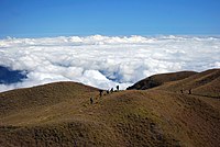 Summit of Mount Pulag, Luzon's highest mountain
 -
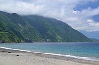
 West coast of Luzon at San Juan overlooking the South China Sea
 -
 The Cagayan Valley atCabagan with the Sierra Madremountains in the background
 -
 Canoes along upstream Cagayan River at Quirino province

.jpg)


Central Luzon

The central section of Luzon is characterized by a flat terrain, known as the Central Luzon plain, the largest in the island in terms of land area. The plain, approximately 11,000 square kilometres (4,200 sq mi) in size, is the country's largest producer of rice, and is irrigated by two major rivers; the Cagayan to the north, and the Pampanga to the south. In the middle of the plain rises the solitary Mount Arayat.
The western coasts of Central Luzon are typically flat extending east from the coastline to the
The
Southern Luzon
Mindoro Island | |
9 | Lamon Bay |
Southern Luzon is dominated by Laguna de Bay (Old Spanish, "Lake of Bay town"), the largest lake in the country. The 949-square-kilometre (366 sq mi) lake is drained into Manila Bay by the Pasig River, one of the most important rivers in the country due to its historical significance and because it runs through the center of Metro Manila.
Located 20 kilometres (12 mi) southwest of Laguna de Bay is Taal Lake, a crater lake containing the Taal Volcano, the smallest in the country. The environs of the lake form the upland Tagaytay Ridge, which was once part of a massive prehistoric volcano that covered the southern portion of the province of Cavite and the whole of Batangas province.
South of Laguna Lake are two solitary mountains, Mount Makiling in Laguna and Batangas provinces, and Mount Banahaw, the highest in the region of Calabarzon.
Southeastern Luzon
The southeastern portion of Luzon is dominated by the
The peninsula's coastline features several smaller peninsulas, gulfs and bays, which include Lamon Bay, San Miguel Bay, Lagonoy Gulf, Ragay Gulf, and Sorsogon Bay.
Outlying islands
Several outlying islands near mainland Luzon are considered part of the Luzon island group. The largest include
Administrative divisions
The island is covered by 8 administrative regions, 30 provinces and, as of 2014[update], 68 cities (8 regions, 38 provinces and 71 cities if associated islands are included).
| Region (designation) |
Location | Population (2020)[2] |
Area[i][61][62] | Density | Regional center |
|---|---|---|---|---|---|
| Ilocos Region (Region I) |

|
5,301,139 (4.9%) |
13,012.60 km2 (5,024.19 sq mi) |
410/km2 (1,100/sq mi) |
San Fernando
(La Union) |
| Cagayan Valley (Region II) |

|
3,685,744 (3.4%) |
28,228.83 km2 (10,899.21 sq mi) |
130/km2 (340/sq mi) |
Tuguegarao |
| Central Luzon (Region III) |

|
12,422,172 (11.4%) |
22,014.63 km2 (8,499.90 sq mi) |
560/km2 (1,500/sq mi) |
San Fernando
(Pampanga) |
| Calabarzon (Region IV-A) |

|
16,195,042 (14.9%) |
16,873.31 km2 (6,514.82 sq mi) |
960/km2 (2,500/sq mi) |
Calamba |
| Southwestern Tagalog Region[ii] (Mimaropa) |

|
3,228,558 (3.0%) |
29,620.90 km2 (11,436.69 sq mi) |
110/km2 (280/sq mi) |
Calapan |
| Bicol Region (Region V) |

|
6,082,165 (5.6%) |
18,155.82 km2 (7,010.00 sq mi) |
330/km2 (850/sq mi) |
Legazpi |
| Cordillera Administrative Region (CAR) |

|
1,797,660 (1.6%) |
19,422.03 km2 (7,498.89 sq mi) |
93/km2 (240/sq mi) |
Baguio |
| National Capital Region (NCR) |

|
13,484,462 (12.4%) |
611.39 km2 (236.06 sq mi) |
22,000/km2 (57,000/sq mi) |
Manila |
Table note(s):
- ^ Land area figures are the sum of each region's component provinces (and/or independent cities), derived from the National Statistical Coordination Board (Philippine Statistics Authority) official website.
- ^ The list includes the associated islands of Luzon (provinces of Marinduque, Occidental Mindoro, Oriental Mindoro, Palawan, Romblon, Batanes, Catanduanes and Masbate).
Tectonics

Luzon is part of the
The North-Southeastern trending braided left-lateral strike-slip
Using geologic and structural data, seven principal blocks were identified in Luzon in 1989: the Sierra Madre Oriental, Angat,
Demographics
| Year | Pop. | ±% p.a. |
|---|---|---|
| 1903 | 4,101,516 | — |
| 1918 | 5,397,401 | +1.85% |
| 1939 | 8,165,778 | +1.99% |
| 1948 | 9,876,263 | +2.14% |
| 1960 | 14,061,448 | +2.99% |
| 1970 | 19,688,100 | +3.42% |
| 1975 | 22,790,274 | +2.98% |
| 1980 | 26,080,694 | +2.73% |
| 1990 | 33,357,887 | +2.49% |
| 1995 | 38,249,776 | +2.60% |
| 2000 | 42,822,686 | +2.45% |
| 2007 | 49,799,956 | +2.10% |
| 2010 | 52,362,999 | +1.84% |
| 2015 | 57,470,097 | +1.79% |
| 2020 | 62,196,942 | +1.57% |
| Source: National Statistics Office[3][65][a] | ||
As of the 2015 census, the population of Luzon Island is 57,470,097 people,[3][a] making it the 4th most populated island in the world.
Cities
_(Diliman,_Quezon_City)(2017-09-07)_cropped.jpg)
| Rank | Name | Region | Pop. | Rank | Name | Region | Pop. | ||
|---|---|---|---|---|---|---|---|---|---|
(2017-08-13).jpg) Quezon City  Manila |
1 | Quezon City | National Capital Region | 2,960,048 | 11 | San Jose del Monte | Central Luzon | 651,813 | .jpg) Caloocan (2018-05-27).jpg) Antipolo |
| 2 | Manila | National Capital Region | 1,846,513 | 12 | Makati | National Capital Region | 629,616 | ||
| 3 | Caloocan | National Capital Region | 1,661,584 | 13 | Las Piñas | National Capital Region | 606,293 | ||
| 4 | Antipolo | Calabarzon | 887,399 | 14 | Muntinlupa | National Capital Region | 543,445 | ||
| 5 | Taguig | National Capital Region | 886,722 | 15 | Calamba | Calabarzon | 539,671 | ||
| 6 | Pasig | National Capital Region | 803,159 | 16 | Imus | Calabarzon | 496,794 | ||
| 7 | Valenzuela | National Capital Region | 714,978 | 17 | Angeles | Central Luzon | 462,928 | ||
| 8 | Dasmariñas | Calabarzon | 703,141 | 18 | Marikina | National Capital Region | 456,059 | ||
| 9 | Parañaque | National Capital Region | 689,992 | 19 | General Trias | Calabarzon | 450,583 | ||
| 10 | Bacoor | Calabarzon | 664,625 | 20 | Pasay | National Capital Region | 440,656 | ||
.svg)
(2015 Census, 100,000+ inhabitants)[68]
Ethnic groups

Seven major
Other ethnic groups lesser in population include the
Due to historical centuries-old migrations, populations of ethnic
Languages

Almost all of the languages of Luzon belong to the
Religion
Like most of the Philippines, the major religion in Luzon is
There are also sizable communities of

Economy
The economy of the island is centered in
See also
Notes
References
- ^ a b c "Islands of Philippines". Island Directory Tables. United Nations Environment Programme. Archived from the original on April 28, 2019. Retrieved April 18, 2016.
- ^ a b Census of Population (2020). Table B - Population and Annual Growth Rates by Province, City, and Municipality - By Region. Philippine Statistics Authority. Retrieved July 8, 2021.
- ^ a b c Census of Population (2015). Highlights of the Philippine Population 2015 Census of Population. Philippine Statistics Authority. Retrieved June 20, 2016.
- ISBN 9783319519265. Archivedfrom the original on March 26, 2023. Retrieved December 22, 2018.
- ^ Zaide, Sonia M. The Philippines, a Unique Nation. p. 50.
- ISBN 978-1-57607-770-2. Archivedfrom the original on March 26, 2023. Retrieved September 15, 2020.
- ^ a b Roberts, Edmund (1837). Embassy to the Eastern Courts of Cochin-China, Siam, and Muscat. New York: Harper & Brothers. p. 59. Archived from the original on October 15, 2013. Retrieved October 15, 2013.
- ^ a b Bautista, Eulito U.; Javier, Evelyn F. (2008). "Rice Production Practices: PIDS Research Paper Series 2008-02" (PDF). Philippine Institute of Development Studies Research Papers Series. Philippine Institute of Development Studies: 44. Archived from the original (PDF) on August 15, 2017. Retrieved May 29, 2019.
- ^ Van Linschoten, Jan Huygen (1596). "Exacta & Accurata Delineatio cum Orarum Maritimarum tum etjam locorum terrestrium quae in Regionibus China, Cauchinchina, Camboja sive Champa, Syao, Malacca, Arracan & Pegu". Barry Lawrence Ruderman Antique Maps Inc. Archived from the original on September 1, 2019. Retrieved June 16, 2021.
- ^ Quad, Matthias; Bussemachaer, Johann (1598). "Asia Partiu Orbis Maxima MDXCVIII". Barry Lawrence Ruderman Antique Maps Inc. Archived from the original on September 1, 2019. Retrieved June 16, 2021.
- ^ Hondius, Jodocus (1606). "India Orientalis". Barry Lawrence Ruderman Antique Maps Inc. Archived from the original on June 24, 2021. Retrieved June 16, 2021.
- ^ Jansson, Jan (1630). "Indiae Orientalis Nova Descriptio". Barry Lawrence Ruderman Antique Maps Inc. Archived from the original on June 24, 2021. Retrieved June 16, 2021.
- ^ Blaeu, Willem Janszoon (1642). "India quae Orientalis dicitur et Insulae Adiacentes". Barry Lawrence Ruderman Antique Maps Inc. Archived from the original on June 24, 2021. Retrieved June 16, 2021.
- ^ Blaeu, Willem Janszoon (1635). "Asia Noviter Delineata". Barry Lawrence Ruderman Antique Maps Inc. Archived from the original on June 24, 2021. Retrieved June 16, 2021.
- ^ Hondius, Henricus (1636). "India quae Orientalis dicitur et Insulae Adiacentes". Barry Lawrence Ruderman Antique Maps Inc. Archived from the original on June 24, 2021. Retrieved June 16, 2021.
- ^ Mariette, Pierre (1650). "Carte Generale Des Indes Orientales et des Isles Adiacentes". Barry Lawrence Ruderman Antique Maps Inc. Archived from the original on June 24, 2021. Retrieved June 16, 2021.
- ISBN 9789710546527.
- ^ ISBN 971-550-135-4.
- ^ a b Pires, Tomé (1944). A suma oriental de Tomé Pires e o livro de Francisco Rodriguez: Leitura e notas de Armando Cortesão [1512 – 1515] [The Summa Oriental of Tomé Pires and the book by Francisco Rodriguez: Reading and notes by Armando Cortesão [1512 – 1515]] (in Portuguese). Translated by Cortesão, Armando. Cambridge: Hakluyt Society.
- ^ ISBN 0-226-46732-5.
- ^ ISBN 978-0-7315-2132-6. Archivedfrom the original on September 2, 2007. Retrieved August 30, 2015.
- ^ Zorc, David (1993). "The Prehistory and Origin of the Tagalog People". In Øyvind Dahl (ed.). Language - a doorway between human cultures : tributes to Dr. Otto Chr. Dahl on his ninetieth birthday (PDF). Oslo: Novus. pp. 201–211.
- ^ Morrow, Paul. "Laguna Copperplate Inscription". Mts.net. Archived from the original on February 5, 2008. Retrieved December 19, 2010.
- ^ Go, Bon Juan (2005). "Ma'I in Chinese Records – Mindoro or Bai? An Examination of a Historical Puzzle". Philippine Studies. 53 (1): 119–138. Archived from the original on October 21, 2013.
- ISBN 978-9711002268.
- ]
- ^ Manansala, Paul Kekai (September 5, 2006). "Quests of the Dragon and Bird Clan: Luzon Jars (Glossary)". Quests of the Dragon and Bird Clan. Archived from the original on September 4, 2007. Retrieved December 19, 2010.
- ^ South East Asia Pottery – Philippines. Seapots.com. Retrieved on 2010-12-19. Archived October 19, 2014, at the Wayback Machine
- ^ Reading Song-Ming Records on the Pre-colonial History of the Philippines Archived February 13, 2023, at the Wayback Machine By Wang Zhenping Page 256.
- S2CID 162707729.
- ISBN 978-99917-2-372-3.
- ^ Ho 2009, p. 33.
- ^ Karnow 2010, p. 84.
- ^ Encyclopædia Britannica, Volume 9. Contributor: Walter Yust. EncyclopÆdia Britannica. 1954. p. 75. Archived from the original on March 26, 2023. Retrieved June 21, 2019.
{{cite book}}: CS1 maint: others (link) - ^ "Philippine Almanac & Handbook of Facts" 1977, p. 59.
- ISBN 978-616-222-235-1.
- ^ Scott, William Henry (1989). "Filipinos in China in 1500" (PDF). Asian Studies. 21: 8. Archived from the original (PDF) on July 24, 2015. Retrieved June 10, 2015.
- ^ Pires, Tomé, A suma oriental de Tomé Pires e o livro de Francisco Rodriguez: Leitura e notas de Armando Cortesão [1512–1515], translated and edited by Armando Cortesao, Cambridge: Hakluyt Society, 1944.
- ^ Antony, Robert J. Elusive Pirates, Pervasive Smugglers: Violence and Clandestine Trade in the Greater China Seas. Hong Kong: Hong Kong University Press, 2010. Print, 76.
- ^ Junker, Laura L. Raiding, Trading, and Feasting: The Political Economy of Philippine Chiefdoms. Honolulu: University of Hawaiì Press, 1999.
- ^ Wilkinson, R J. An Abridged Malay-English Dictionary (romanised). London: Macmillan and Co, 1948. Print, 291.
- ^ Junker, 400. http://sambali.blogspot.com/2014/12/the-borneo-route.html Archived August 3, 2015, at the Wayback Machine
- ^ ISBN 9780226669519.
- ^ Pigafetta, Antonio (1969) [1524]. First voyage round the world. Primo viaggio intorno al globo terraqueo.English. Translated by J.A. Robertson. Manila: Filipiniana Book Guild. Archived from the original on June 22, 2019. Retrieved June 22, 2019.
- ^ Pigafetta 1969, p. 195.
- ^ "Quest of the Dragon and Bird Clan; The Golden Age (Volume III)" -Lungshanoid (Glossary)- By Paul Kekai Manansala
- ^ Chinese in Mexico by Chao Romero, pages 203 to 205
- ^ Barrows, David P. (1905). A History of the Philippines. New York: American Book Company. p. 179. Archived from the original on February 8, 2019. Retrieved October 12, 2018 – via Guttenburg.
Within the walls, there were some six hundred houses of a private nature, most of them built of stone and tile, and an equal number outside in the suburbs, or "arrabales," all occupied by Spaniards ("todos son vivienda y poblacion de los Españoles"). This gives some twelve hundred Spanish families or establishments, exclusive of the religious, who in Manila numbered at least one hundred and fifty, the garrison, at certain times, about four hundred trained Spanish soldiers who had seen service in Holland and the Low Countries, and the official classes.
- ^ See, Stanley Baldwin O. (November 17, 2014). "Binondo: New Discoveries in the World's Oldest Chinatown". GMA News Online. Archived from the original on August 18, 2020. Retrieved October 12, 2018.
- ^ Galaup "Travel Accounts" page 375.
- ISBN 978-1-316-48012-0.
- ^ "Eva Maria Mehl: Forced migration in the Spanish pacific world: From Mexico to the Philippines, 1765–1811" Page 100. Archived May 16, 2022, at the Wayback Machine From the original Spanish language source in the archives of Mexico: "CSIC ser. Consultas riel 208 leg.14 (1774)"
- ^ Peasants, Servants, and Sojourners: Itinerant Asians in Colonial New Spain, 1571–1720 By Furlong, Matthew J. Archived April 29, 2022, at the Wayback Machine "Slaves purchased by the indigenous elites, Spanish and Hokkiens of the colony seemed drawn most often from South Asia, particularly Bengal and South India, and less so, from other sources, such as East Africa, Brunei, Makassar, and Java..." Chapter 2 "Rural Ethnic Diversity" Page 164 Translated from: "Inmaculada Alva Rodríguez, Vida municipal en Manila (siglos xvi–xvii) (Córdoba: Universidad de Córdoba, 1997), 31, 35–36."
- ^ Nigel Gooding, Filipino Involvement in the French-Spanish Campaign in Indochina, archived from the original on August 3, 2020, retrieved July 4, 2008
- ^ Garcia de los Arcos has noted that the Regiment of the King, which had absorbed a large percentage of Mexican recruits and deportees between the 1770s and 1811, became the bastion of discontent supporting the Novales mutiny. ~Garcia de los Arcos, "Criollismo y conflictividad en Filipinas a principios del siglo XIX," in El lejano Oriente espanol: Filipinas ( ˜ Siglo XIX). Actas, ed. Paulino Castaneda ˜ Delgado and Antonio Garcia-Abasolo Gonzalez (Seville: Catedra General Casta ´ nos, ˜ 1997), 586.
- ^ "Filipino-Mexican-South American Connection". filipinokastila.tripod.com. Archived from the original on February 25, 2021. Retrieved February 17, 2021.
- ^ Vidal, Gore; Nielsen, David. "Death in the Philippines | David Nielsen". The New York Review of Books. Archived from the original on October 23, 2022. Retrieved October 23, 2022.
- ^ "Clark Air Base History". Clarkab.org. Archived from the original on January 3, 2019. Retrieved July 14, 2009.
- ^ a b "The Philippines". Archived from the original on February 22, 2009. Retrieved December 6, 2008.
- ISBN 1410224953. Archivedfrom the original on January 25, 2015. Retrieved December 25, 2014.
- ^ "PSGC Interactive; List of Provinces". Philippine Statistics Authority. Archived from the original on January 11, 2013. Retrieved April 3, 2016.
- ^ "PSGC Interactive; List of Cities". Philippine Statistics Authority. Archived from the original on April 29, 2011. Retrieved April 7, 2016.
- ISBN 90-277-1561-0p299
- ISBN 90-6764-132-4p148 fig 4
- ^ Census of Population and Housing (2010). Population and Annual Growth Rates for The Philippines and Its Regions, Provinces, and Highly Urbanized Cities (PDF). National Statistics Office. Retrieved June 29, 2016.
- ^ a b Philippine Statistics Authority (April 2008). "Total Population and Annual Population Growth Rates by Region: Population Censuses 1995, 2000, and 2007". Archived from the original on July 16, 2012. Retrieved April 4, 2010.
- ^ Demographia. (July 2010). Demographia World Urban Areas (World Agglomerations) Population & Projections Archived May 3, 2018, at the Wayback Machine (Edition 6.1). Retrieved March 29, 2011.
- ^ Census of Population (2015). Highlights of the Philippine Population 2015 Census of Population. Philippine Statistics Authority. Retrieved June 20, 2016.
- ^ "Indian Express (2016)". May 18, 2016. Archived from the original on March 3, 2020. Retrieved February 4, 2023.
- ^ Jagor, Fëdor, et al. (1870). The Former Philippines thru Foreign Eyes Archived January 9, 2021, at the Wayback Machine
- ^ PHILIPPINES: ADDITIONAL THREE PERSONS PER MINUTE Archived 2016-03-05 at the Wayback Machine, National Statistics Office Archived 2013-10-04 at the Wayback Machine. Last revised: July 18, 2003. Retrieved November 27, 2006.
- ^ "Index of Agriculture and Fishery Statistics". National Statistics Office. Archived from the original on February 21, 2012. Retrieved December 19, 2010.
Further reading
- Agoncillo, Teodoro A.; Guerrero, Milagros (1975). History of the Filipino People (4 ed.). R. P. Garcia. ISBN 9712345386. Retrieved April 24, 2014.
- Agoncillo, Teodoro A. (1962). Philippine History. Inang Wika Publishing Company. ISBN 9712345386. Retrieved April 24, 2014.
- Alip, Eufronio Melo (1954). Political and Cultural History of the Philippines, Volumes 1-2 (revised ed.). Alip & Sons. Retrieved April 24, 2014.
- Antonio, Eleanor D.; Dallo, Evangeline M.; Imperial, Consuelo M.; Samson, Maria Carmelita B.; Soriano, Celia D. (2007). Turning Points I' 2007 Ed (unabridged ed.). Rex Bookstore, Inc. ISBN 978-9712345388. Retrieved April 24, 2014.
- Bishop, Carl Whiting (1942). War Background Studies, Issues 1-7. Contributor: Smithsonian Institution. Smithsonian Institution. Retrieved April 24, 2014.
- Bishop, Carl Whiting (1942). Origin of Far Eastern Civilizations: A Brief Handbook, Issues 1–7. Contributor: Smithsonian Institution. Smithsonian Institution. Retrieved April 24, 2014.
- Corpuz, Onofre D. (1957). The bureaucracy in the Philippines. Institute of Public Administration, University of the Philippines. Retrieved April 24, 2014.
- Demetrio, Francisco R. (1981). Myths and Symbols: Philippines (2 ed.). National Book Store. Retrieved April 24, 2014.
- Del Castillo y Tuazon, Antonio (1988). Princess Urduja, Queen of the Orient Seas: Before and After Her Time in the Political Orbit of the Shri-vi-ja-ya and Madjapahit Maritime Empire : a Pre-Hispanic History of the Philippines. A. del. Castillo y Tuazon. Retrieved April 24, 2014.
- Farwell, George (1967). Mask of Asia: The Philippines Today. Praeger. Retrieved April 24, 2014.
- Fitzgerald, Charles Patrick (1966). A concise history of East Asia. Praeger. Retrieved April 24, 2014.
- Ho, Khai Leong, ed. (2009). Connecting and Distancing: Southeast Asia and China (illustrated ed.). Institute of Southeast Asian Studies. ISBN 978-9812308566. Retrieved April 24, 2014.
- Karnow, Stanley (2010). In Our Image: America's Empire in the Philippines (unabridged ed.). Random House LLC. ISBN 978-0307775436. Retrieved April 24, 2014.
- Krieger, Herbert William (1942). Peoples of the Philippines, Issue 4. Vol. 3694 of Publication (Smithsonian Institution). Smithsonian Institution. ISBN 9780598408662. Retrieved April 24, 2014.
- Lucman, Norodin Alonto (2000). Moro Archives: A History of Armed Conflicts in Mindanao and East Asia. FLC Press. Retrieved April 24, 2014.
- Liao, Shubert S. C., ed. (1964). Chinese participation in Philippine culture and economy. Bookman. Archived from the original on November 9, 2006. Retrieved April 24, 2014.
- Manuel, Esperidion Arsenio (1948). Chinese Elements in the Tagalog Language: With Some Indication of Chinese Influence on Other Philippine Languages and Cultures, and an Excursion Into Austronesian Linguistics. Contributor: Henry Otley Beyer. Filipiniana Publications. Retrieved April 24, 2014.
- Ostelius, Hans Arvid (1963). Islands of Pleasure: A Guide to the Philippines. G. Allen & Unwin. Retrieved April 24, 2014.
- Panganiban, José Villa; Panganiban, Consuelo Torres (1965). The literature of the Pilipinos: a survey (5 ed.). Limbagang Pilipino. Retrieved April 24, 2014.
- Panganiban, José Villa; Panganiban, Consuelo Torres- (1962). A Survey of the Literature of the Filipinos (4 ed.). Limbagang Pilipino. Retrieved April 24, 2014.
- Quirino, Carlos (1963). Philippine Cartography, 1320–1899 (2 ed.). N. Israel. Retrieved April 24, 2014.
- Ravenholt, Albert (1962). The Philippines: A Young Republic on the Move. Van Nostrand. Retrieved April 24, 2014.
- Sevilla, Fred; Balagtas, Francisco (1997). Francisco Balagtas and the roots of Filipino nationalism: life and times of the great Filipino poet and his legacy of literary excellence and political activism. Trademark Pub. Corp. ISBN 9789719185802. Retrieved April 24, 2014.
- Spencer, Cornelia (1951). Seven Thousand Islands: The Story of the Philippines. Aladdin Books. Retrieved April 24, 2014.
- Tan, Antonio S. (1972). The Chinese in the Philippines, 1898–1935: A Study of Their National Awakening. R. P. Garcia Publishing Company. Retrieved April 24, 2014.
- Zaide, Gregorio F. (1957). The Philippines since pre-Spanish times.-v. 2. The Philippines since the British invasion. Vol. 1 of Philippine Political and Cultural History (revised ed.). Philippine Education Company. Retrieved April 24, 2014.
- Zaide, Gregorio F. (1979). The Pageant of Philippine History: Political, Economic, and Socio-cultural, Volume 1. Philippine Education Company. Retrieved April 24, 2014.
- Philippines (Republic). Office of Cultural Affairs (1965). The Philippines: a Handbook of Information. Contributor: National Economic Council (Philippines) (revised ed.). Republic of the Philippines, Department of Foreign Affairs. Retrieved April 24, 2014.
- Philippine Chinese Historical Association (1975). The Annals of Philippine Chinese Historical Association, Volumes 5–8 (revised ed.). Retrieved April 24, 2014.
- IAHA Conference (1962). Biennial Conference Proceedings, Issue 1. Philippine Historical Association. Retrieved April 24, 2014.
- The Philippines: A Handbook of Information. Contributor: Philippine Information Agency. 1955. Retrieved April 24, 2014.
{{cite book}}:|work=ignored (help)CS1 maint: others (link) - University of Manila Journal of East Asiatic Studies, Volume 7. Contributors: Manila (Philippines) University, University of Manila (revised ed.). University of Manila. 1959. Retrieved April 24, 2014.
{{cite book}}: CS1 maint: others (link) - Unitas, Volume 30, Issues 1–2. Contributor: University of Santo Tomás. University of Santo Tomás. 1957. Retrieved April 24, 2014.
{{cite book}}: CS1 maint: others (link) - The Researcher, Volume 2, Issue 2. Contributors: University of Pangasinan, Dagupan Colleges. Dagupan Colleges. 1970. Retrieved April 24, 2014.
{{cite book}}: CS1 maint: others (link) - Philippine Social Sciences and Humanities Review, Volumes 24–25. Contributor: University of the Philippines. College of Liberal Arts. 1959. Retrieved April 24, 2014.
{{cite book}}: CS1 maint: others (link) - Philippine Social Sciences and Humanities Reviews, Volume 24, Issues 1–2. Contributors: Philippine Academy of Social Sciences, Manila, University of the Philippines. College of Liberal Arts. College of Liberal Arts, University of the Philippines. 1959. Retrieved April 24, 2014.
{{cite book}}: CS1 maint: others (link) - Studies in Public Administration, Issue 4. Contributor: University of the Philippines. Institute of Public Administration. Institute of Public Administration, University of the Philippines. 1957. Retrieved April 24, 2014.
{{cite book}}: CS1 maint: others (link) - Proceedings [of The] Second Biennial Conference, Held at Taiwan Provincial Museum, Taipei, Taiwan. Republic of China, October 6–9, 1962. Tʻai-pei. 1963. Retrieved April 24, 2014.
- Yearbook. 1965. Retrieved April 24, 2014.
- Philippine Almanac & Handbook of Facts. 1977. Retrieved April 24, 2014.
External links
 Geographic data related to Luzon at OpenStreetMap
- . The American Cyclopædia. 1879.
| 100,000 km2 (38,610 sq mi) and greater | ||
|---|---|---|
| 20,000–99,999 km2 (7,722–38,610 sq mi) |
| |


| International | |
|---|---|
| National | |
| Other | |