
Norton St Philip
| Norton Saint Philip | |
|---|---|
Avon and Somerset | |
| Fire | Devon and Somerset |
| Ambulance | South Western |
| UK Parliament | |
| Website | Norton St Philip Parish Council |
Norton St Philip is a village and civil parish in Somerset, England. The village lies about 5+1⁄2 miles (9 km) south of the city of Bath and 5 miles (8 km) north of the town of Frome on the eastern slopes of the Mendip Hills. It is situated on the A366 between Trowbridge and Radstock, and on the B3110 between Bath and Frome.
New development greatly increased the size of the village in the later 20th century, but there has been a significant reduction in services, with the police station, post office and shops all having closed. This was partly reversed by the opening of a new supermarket, incorporating a post office, in 2016.
History
The earliest signs of habitation can be found a mile to the east of the current village, where the
Norton St Philip was the site of the
The
Governance
The
From 1894 to 1974, the village was part of
It is also part of the
Transport
Today the village is largely a
Religious sites
The church of St Philip and St James dates from the 14th century with restoration in 1847 by Sir George Gilbert Scott. It has been designated by English Heritage as a Grade II* listed building.[10]
Gallery of images
-
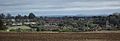 View of the village from up the hill
 -
-
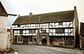
 Frontal view of The George Inn
 -
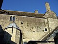 View from courtyard of The George Inn
 -
 The Plaine guest house
 -
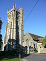 Church of St Philip and St James


References
- ^ "Norton St Philip Parish". Neighbourhood Statistics. Office for National Statistics. Retrieved 1 January 2014.
- ^ "Somerset Hundreds". GENUKI. Retrieved 22 October 2011.
- ^ Historic England. "The George Inn (1174953)". National Heritage List for England. Retrieved 1 March 2008.
- ^ ISBN 0-906456-98-3.
- ISBN 1-902007-01-8.
- ^ "Frome RD". A Vision of Britain Through Time. University of Portsmouth. Retrieved 4 January 2014.
- ^ "Norton St Philip (Primary Village)". Mendip Council. Retrieved 26 February 2018.
- ^ "Norton St Phillip villagers frustrated over lorries breaking weight limits". BBC. Retrieved 26 February 2018.
- ^ "Traffic Regulation Order – Determination Report: (The A366, Norton St Philip)(7.5 Tonne Weight Restriction Order) 2009" (PDF). Somerset County Council. Retrieved 27 March 2010.
- ^ Historic England. "Church of St Philip and St James (1345373)". National Heritage List for England. Retrieved 1 March 2008.
External links
- The Somerset Urban Archaeological Survey: Norton St Philip, by Clare Gathercole
- The Norton St Philip Homepage

| International | |
|---|---|
| National | |