
Nyköping
Nyköping | |
|---|---|
 Images of Nyköping | |
|
UTC+2 (CEST) | |
| Postal code | 611 xx |
| Area code | (+46) 155 |
| Website | www.nykoping.se (in English) |
Nyköping (Swedish pronunciation: [ˈnŷːˌɕøːpɪŋ])[2] is a locality and the seat of Nyköping Municipality, Södermanland County, Sweden with 32,759 inhabitants as of 2017.[3] The city is also the capital of Södermanland County.
Including Arnö, the locality on the southern shore of the bay just a couple of kilometres from the city centre, Nyköping would have above 36,000 inhabitants. Commonly, Arnö is referred to as a part of the city proper. It forms a wider conurbation with the neighbouring minor municipality and town of Oxelösund 10 kilometres (6.2 mi) south of its outskirts. The municipality is much larger, although sparsely populated outside of the urban area.
Nyköping directly translates to 'Newmarket' into English. The prefix ny is translated as 'new' and köping is an old Swedish word for a market place, commonly used as a suffix for cities in the south central region of the country (see Köping). Nyköping is the name that appears on coins in 1230 and in historical records from the 13th century. Aros is the name of the town found in the acheological records from before 1230, indicating a new era and a new name sometime around 1230. The city is located near the open Baltic Sea on the Stadsfjärden inlet, and is regarded as a coastal location. Rivers Nyköpingsån and Kilaån reach the Baltic Sea through the southern end of downtown. The former river splits the town down the middle into an eastern and western part. The river Svärtaån empties into the sea by the locality Sjösa, east of the town. There are multiple other inlets in the municipality, which has an extensive shoreline.
Typical of the region, the landscape is influenced by post-glacial rebound after the latest ice age. For thousands of years, the land of downtown Nyköping was an archipelago where the hills in town today formed many islands, while the flatter parts of the town were the seafloor. With four peaks above 50 metres (160 ft), the highest point within town limits is 59 metres (194 ft) at Ekensberg in the northeastern fringes.[4]
Nyköping is also the home of Stockholm Skavsta Airport which is located less than 10 kilometres (6.2 mi) from the city centre. Nyköping is part of the wider area of the Mälaren Valley, located around 100 kilometres (62 mi) south of inner Stockholm and 60 kilometres (37 mi) east of Norrköping, the nearest larger city. The municipal border between Nyköping and Norrköping marks the point where the historical lands Götaland and Svealand converge on the east coast.
It retains an oceanic/continental climate hybrid, causing warm summers and winters around the freezing point with variable snow cover.
History
The area bears traces of settlers since around 2000 BC. In the early
In 1317 the Nyköping Banquet took place, a renowned episode in Sweden's history, when King Birger of Sweden captured his two brothers as revenge for earlier sufferings and had them imprisoned without food until they starved to death (See Nyköpings gästabud).
The earliest known

In 1665 large parts of the city including the fortress were damaged in a fire. The same thing happened again in 1719 when Russian troops invaded the city. It was then rebuilt with its current street plan.
Nyköping was

20th century

Nyköping was the town where Nordiska Kompaniet had its furniture factory. The business created a spin-off named ANA, which licence-built American and English cars, as Plymouth, De Soto, Hillman and Sunbeam. The company was later purchased by Saab Automobile and led to SAAB becoming the largest employer in the town during the 1980s, as well as the relocation of the headquarters to Spelhagen. But when GM bought SAAB from Investor AB, the headquarters was moved back to Trollhättan and about two thousand lost their jobs.[5]
Military history
Nyköping has been a stronghold for the reconnaissance squadrons of the Swedish Air Force. Between 1941 and 1980, the nearby Stockholm Skavsta Airport was hosting the Södermanland Wing (F 11) which had three squadrons with reconnaissance aircraft. It was the only dedicated reconnaissance wing in the Swedish Air Force. The city has also hosted the flying school of the Swedish Army which was located at Brandholmen between 1963 and 1985.
Geography
Position
Nyköping lies about 100 kilometres (62 mi) south-west of capital Stockholm along the Baltic Sea. It is roughly 60 kilometres (37 mi) north-east of Norrköping, both cities being accessible by highway-divided motorway. It is also about 80 kilometres (50 mi) south of Eskilstuna; the largest settlement of the county. The northern areas of the city is on exactly the same parallel of 58° 46' N as Canadian 'polar bear capital of the world' Churchill, demonstrating how warm the climate is in comparison in spite of its northerly latitude. The southern edge of the municipality also straddles the same parallel as the northernmost point of mainland Scotland at Thurso – that has a much more narrower range of temperature. The southern edge of the municipality is the southernmost point of Svealand, the middle of Sweden's traditional three crown lands that once formed the country. The city is located at a few miles more southerly latitude than the country's northernmost west coast town of Strömstad. The line of 17°E goes through Nyköping, thus the city is eight minutes ahead in solar time of the GMT +1 line that Sweden follows for its time zone.
Living environment
Nyköping is the exodus of a small river named
Populated areas of Nyköping
- Brandholmen
- Brandkärr
- Bryngelstorp
- Ekensberg
- Fågelbo
- Isaksdal
- Harg
- Herrhagen (at Arnö)
- Högbrunn
- Kuggnäs (at Arnö)
- Långsätter (at Arnö)
- Malmbryggshagen
- Myntan (at Arnö)
- Oppeby
- Oxbacken
- Påljungshage
- Rosenkälla
- Stenkulla
- Väster (the West)
- Öster (the East)
- Östra bergen (the Eastern Mountains)
The area of Gumsbacken only carries a large shopping mall centre but is part of the city proper.
Connected areas
The rural localities of Sjösa, Bergshammar, Svalsta and Enstaberga located within 10 kilometres (6.2 mi) are connected to the city centre by cycle tracks with permanent floodlightning. In addition there is a nature and coastal area called Tjuvholmen east of the city centre that is part of the locality with many holiday homes. Tjuvholmen lacks an asphalted access road and is in general seen as a rural area in spite of its proximity to the city centre. East of Arnö on the southern shore there are similar areas such as Örstig which is connected by asphalt road and cycle tracks to Arnö and Nyköping. Other nearby rural areas on the southern shore include holiday home areas such as Linudden and Örstigsnäs and also the coastal camping place of Strandstugeviken. There is also lighted cycling tracks all the way south roughly 15 kilometres (9.3 mi) to neighbouring city Oxelösund, making pedestrian and biking transport to nearby areas effective and avoids potentially dangerous contacts with motor vehicles.
Elections
Nyköping is the seat of Nyköping Municipality and this table just records how the urban area (including Arnö) has voted, contrasting with the rural electoral wards.
Riksdag
| Year | % | Votes | V | S
|
MP | C | L | KD | M
|
SD | ND | Other |
|---|---|---|---|---|---|---|---|---|---|---|---|---|
| 1973[6] | 91.5 | 20,920 | 3.3 | 53.9 | 20.1 | 7.2 | 2.0 | 13.0 | 0.5 | |||
| 1976[7] | 91.9 | 21,930 | 3.3 | 53.4 | 17.3 | 10.0 | 1.7 | 14.0 | 0.4 | |||
| 1979[8] | 90.8 | 21,533 | 4.1 | 54.6 | 12.0 | 9.5 | 1.6 | 17.7 | 0.5 | |||
| 1982[9] | 91.2 | 21,967 | 4.6 | 54.9 | 1.7 | 10.9 | 5.0 | 1.8 | 21.0 | 0.2 | ||
| 1985[10] | 89.0 | 22,017 | 4.0 | 53.8 | 1.6 | 7.8 | 13.3 | 19.3 | 0.3 | |||
| 1988[11] | 86.7 | 21,245 | 4.8 | 51.2 | 5.0 | 7.1 | 11.9 | 2.3 | 17.3 | 0.5 | ||
| 1991[12] | 88.2 | 21,210 | 3.6 | 44.7 | 2.5 | 5.9 | 9.0 | 6.5 | 20.3 | 6.7 | 0.9 | |
| 1994[13] | 87.1 | 21,560 | 5.2 | 53.3 | 4.2 | 4.7 | 7.1 | 3.7 | 20.3 | 0.7 | 0.9 | |
| 1998[14] | 82.1 | 20,168 | 10.7 | 44.7 | 3.9 | 3.5 | 4.6 | 11.8 | 19.3 | 1.7 | ||
| 2002[15] | 81.1 | 20,444 | 7.7 | 49.1 | 4.0 | 3.6 | 12.3 | 9.0 | 13.0 | 0.7 | 0.6 | |
| 2006[16] | 82.1 | 21,026 | 4.8 | 42.3 | 5.1 | 5.2 | 7.3 | 7.5 | 23.8 | 2.0 | 1.9 | |
| 2010[17] | 83.8 | 22,502 | 4.6 | 36.0 | 8.6 | 4.3 | 7.5 | 5.5 | 27.6 | 4.9 | 1.0 | |
| 2014[18] | 85.4 | 23,751 | 4.8 | 35.6 | 7.9 | 4.4 | 4.9 | 4.5 | 23.6 | 11.1 | 3.2 | |
| 2018[19] | 85.9 | 24,430 | 6.6 | 33.7 | 4.6 | 7.4 | 5.1 | 6.3 | 20.9 | 14.0 | 1.4 |
Transportation
Buses
Nyköping's intercity and city bus-links are operated by Nobina Sverige. The city bus network consists of seven lines:[20]
| Number | Origin | Final destination | Frequency | Distance |
|---|---|---|---|---|
| 1 | Bryngelstorp | Harg | Every 15 minutes | 11.4 km (7.1 mi) |
| 2 | Arnö | Brandkärr | Every 15 minutes | 7.8 km (4.8 mi) |
| 3 | Bus station | Brandholmen | Twice an hour | 3.4 km (2.1 mi) |
| 160 | Myntan (North Arnö) | Myntan (North Arnö) | Every 40 minutes | NA |
| 161 | Bus station | Bus station (via Brandkärr) | 10 times/day | NA |
| 162 | Bus station | Bus station (via Isaksdal) | 10 times/day | NA |
| 164 | Bryngelstorp | Bus station | Morning bus, 1 time/day | NA |
Coaches to Stockholm and Gothenburg are operated by Flixbus.
Rail

The city is located on a branch line to the
| Line | Vehicles | Operator |
|---|---|---|
| Stockholm – Nyköping – Norrköping | SJ Rc | SJ AB |
The planned new high-speed rail Ostlänken going from Stockholm to Linköping will have two stops in the city, one at the new planned train station and one at Skavsta Airport. The railway will later be connected with the planned high-speed rail Götalandsbanan going from Linköping to Gothenburg Which will make it possible to go from Stockholm to Gothenburg in 2 hours. It's planned to be finished between 2033 and 2035.
Air
. The airport is located about 10 kilometers outside of the city and is connected with bus from the city center.Climate
Nyköping has, along with the rest of
The seaside effect due to southerlies frequently travelling over water often prevents heat waves from impacting Nyköping, resulting in lower
The inland areas of the municipality are very much similar to the coastal areas, but the weather station at Skavsta shows lower summer mean temperatures than Oxelösund, indicating that the inner city wider urban area nearer the water has milder nights year round. Both stations are within a meteorological relevant range from the city centre.
After many years without any weather station, the
| Climate data for Nyköping | |||||||||||||
|---|---|---|---|---|---|---|---|---|---|---|---|---|---|
| Month | Jan | Feb | Mar | Apr | May | Jun | Jul | Aug | Sep | Oct | Nov | Dec | Year |
| Mean daily maximum °C (°F) | 1 (34) |
1 (34) |
6 (43) |
11 (52) |
16 (61) |
20 (68) |
23 (73) |
22 (72) |
17 (63) |
11 (52) |
6 (43) |
3 (37) |
11 (53) |
| Mean daily minimum °C (°F) | −4 (25) |
−4 (25) |
−2 (28) |
1 (34) |
6 (43) |
10 (50) |
13 (55) |
12 (54) |
8 (46) |
4 (39) |
2 (36) |
−2 (28) |
4 (39) |
| Average precipitation mm (inches) | 40.8 (1.61) |
27.2 (1.07) |
28.2 (1.11) |
32.2 (1.27) |
33.1 (1.30) |
46.0 (1.81) |
66.4 (2.61) |
58.4 (2.30) |
56.7 (2.23) |
50.8 (2.00) |
56.2 (2.21) |
49.0 (1.93) |
544.9 (21.45) |
| Source: SMHI.se[25] | |||||||||||||
Sports
Nyköping has two major sport clubs:
- .
- Nyköpings Hockey is the local ice hockey club; its home rink is PEAB Arena.
Other clubs are football club Harg, the football and handball teams of IFK Nyköping and also includes Onyx in floorball.
The city is yet to have a team in the major football or hockey leagues of Sweden, with stints in the second tiers being the greatest achievements for both main sides.
Sights
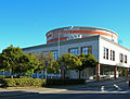
Nyköping includes the cinema Biostaden which houses Sweden's largest cinema screen.[27] The cinema was newly built from the ground in 2012. It is located in Högbrunn.
Nyköpings Stadsbibliotek (Nyköping City Library) is located in the city center, which offers various book clubs and activities for children. There is free Internet access and wifi for visitors. It has books of all genres, for all ages, and in many languages.[28]

-
 City hall
 -
 Library and cultural center
 -

-
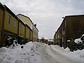 Vattengränd, the oldest street in Nyköping
 -
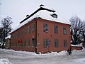 Westerlingska gården
 -
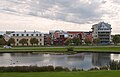
 Rosvalla Highrise
 -
 Brandholmen Seaside houses
 -
 Sankta AnnaCatholic Church
 -
 Sankta Katarina Lutheran Church, Arnö
 -
 Hjortensberg Pentecostal Church
 -
 Villa Sturegården, by architect Gunnar Asplund
 -
 Former headquarters of Sunlights AB
 -
 Spelhagen, former location of AB Nyköpings Automobilfabrik
 -
 Castle main gate
 -
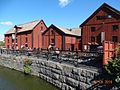 Rökeriet Nyköping


Twin cities
References
- ^ a b "Tätorternas landareal, folkmängd och invånare per km2 2005 och 2010" (in Swedish). Statistics Sweden. 14 December 2011. Archived from the original on 27 January 2012. Retrieved 10 January 2012.
- ^ Duden Aussprachewörterbuch.
- ^ "Tätorter 2015; befolkning 2010-2017" [Urban areas 2015; population 2010-2017]. Statistics Sweden. Retrieved 3 September 2018.[permanent dead link]
- ^ "Min Karta, Lantmäteriet, 58°45'53"N 17°2'1.6"E" (in Swedish). Lantmäteriet. Retrieved 26 August 2022.
- ^ http://www.sn.se/polopoly_fs/1.561819.1259760309!/sn-saab-20090131.pdf[permanent dead link]
- SCB.
- SCB.
- SCB.
- SCB.
- SCB.
- SCB.
- SCB.
- SCB.
- SCB.
- Valmyndigheten.
- Valmyndigheten.
- Valmyndigheten.
- Valmyndigheten.
- Valmyndigheten.
- ^ "Tidtabeller i PDF-format". www.sormlandstrafiken.se. Retrieved 2016-06-02.
- ^ "Nykoping, Sweden Climate Summary". Weatherbase. Retrieved 17 December 2014.
- ^ "Nykoping, Sweden Temperature averages". Weatherbase. Retrieved 17 December 2014.
- SMHI. Retrieved 3 August 2023.
- SMHI. Retrieved 3 August 2023.
- ^ "Weather Information for Nyköping 1961–1990". Swedish Meteorological Institute. Retrieved 31 October 2012.
- ^ "Nyköpings BIS – Fotboll Klubb". Retrieved 2010-09-16.
- ^ "Biostaden". Retrieved 2015-06-03.
- ^ "Welcome – Nykoping". bibliotek.nykoping.se. Retrieved 2015-06-03.
External links
- Official website (in English)
- Visit Nyköping – The official visitors' guide
- Nyköping Facebook – The official Facebook-page
 | ||
|  | |||||||||||||||||||||||||||||||||||||||||||||||||||||||||||||||||||||||||||||||||||||||||||||||||||||||||||||||||||||||||||||||||||||||||||||||||||||||||||||
as of 2020, according to Statistics Sweden | ||||||||||||||||||||||||||||||||||||||||||||||||||||||||||||||||||||||||||||||||||||||||||||||||||||||||||||||||||||||||||||||||||||||||||||||||||||||||||||||
| International | |
|---|---|
| National | |
| Geographic | |