
Nzérékoré Region
This article needs additional citations for verification. (December 2009) |
8°30′N 9°0′W / 8.500°N 9.000°W
Nzérékoré | |
|---|---|
 Nzérékoré Region in Guinea | |
| Country | Guinea |
| Regional capital | Nzérékoré |
| Area | |
| • Total | 37,658 km2 (14,540 sq mi) |
| Population (2014 census) | |
| • Total | 1,663,582 |
| • Density | 44/km2 (110/sq mi) |
| HDI (2017) | 0.447[1] low · 3rd of 8 |
The Nzérékoré Region (N'Ko: ߒߛߙߍߜߍ߬ߘߍ߫ ߕߌ߲߬ߞߎߘߎ߲) is a region in the southern part of Guinea. Its capital and largest city is Nzérékoré. It is one of the eight regions of Guinea. It is bordered by the countries of Sierra Leone, Liberia, and Ivory Coast, and the Guinean regions of Kankan and Faranah.
Administrative divisions
Nzérékoré Region is divided into six prefectures; which are further sub-divided into 66 sub-prefectures:
- Beyla Prefecture
- Guéckédou Prefecture
- Lola Prefecture
- Macenta Prefecture
- Nzérékoré Prefecture
- Yomou Prefecture
Geography
Nzérékoré Region is traversed by the northwesterly line of equal latitude and longitude.
The region includes several forested highlands, including the
Simandou Massif, and Ziama Massif
.
The region contains the headwaters of several rivers. The
St. Paul, St. John, Cavalla, and Sassandra rivers flow southwards through Sierra Leone, Liberia, and Ivory Coast
to empty into the Atlantic Ocean.
Gallery
-
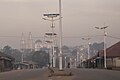 N'Zérékoré city with the Grand Mosque
 -
 Chimpanzees (Mount Nimba)
 -
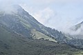 Mount Nimba
 -
 Ziama Massif


See also
References
- ^ "Sub-national HDI - Area Database - Global Data Lab". hdi.globaldatalab.org. Retrieved 2018-09-13.
This Guinea location article is a stub. You can help Wikipedia by expanding it. |