
Oakland (Pittsburgh)
Oakland | |
|---|---|
UTC-4 (EDT) | |
| GNIS feature ID | 1182822 |
Oakland is the academic and healthcare center of
In addition, the Pittsburgh Bureau of Fire operates Fire Station No. 14 on McKee Place and Fire Station No. 10 on Allequippa Street.
Neighborhoods
North Oakland | |
|---|---|
 | |
| Area | |
| • Total | 0.499 sq mi (1.29 km2) |
| Population (2010)[1] | |
| • Total | 10,551 |
| • Density | 21,000/sq mi (8,200/km2) |
Central Oakland | |
|---|---|
 | |
| Area | |
| • Total | 0.281 sq mi (0.73 km2) |
| Population (2010)[1] | |
| • Total | 6,086 |
| • Density | 22,000/sq mi (8,400/km2) |
South Oakland | |
|---|---|
 | |
| Area | |
| • Total | 0.508 sq mi (1.32 km2) |
| Population (2010)[1] | |
| • Total | 2,969 |
| • Density | 5,800/sq mi (2,300/km2) |
West Oakland | |
|---|---|
 | |
| Area | |
| • Total | 0.215 sq mi (0.56 km2) |
| Population (2010)[1] | |
| • Total | 2,604 |
| • Density | 12,000/sq mi (4,700/km2) |
Oakland is officially divided into four
| Year | Pop. | ±% |
|---|---|---|
| 1940 | 25,843 | — |
| 1950 | 28,430 | +10.0% |
| 1960 | 23,806 | −16.3% |
| 1970 | 22,702 | −4.6% |
| 1980 | 21,157 | −6.8% |
| 1990 | 21,548 | +1.8% |
| 2000 | 20,417 | −5.2% |
| 2010 | 22,210 | +8.8% |
| [4][5] Source: University of Pittsburgh[6] | ||
North Oakland
North Oakland can be loosely defined as the area of Oakland between Neville and Bouquet Streets, encompassing all of Craig Street and running north to Polish Hill. The Cathedral of Learning, the engineering or midsection of the University of Pittsburgh campus, and the Craig Street business district are in North Oakland.
Central Oakland
Central Oakland is bordered by Schenley Park, the Boulevard of the Allies, Fifth Avenue, and Halket Street. Many students at the University of Pittsburgh who decide to live off-campus reside in this neighborhood. Many of its homes are historic masonry structures dating from the turn of the century. The area is often confused with South Oakland. Its Main Business District runs along Forbes and Fifth Avenue, and contains a diversity of restaurants, retailers, and financial services. These businesses are organized by the Oakland Business Improvement District (OBID). Smaller business districts in Central Oakland provide additional dining options along Atwood Street and Semple Street. It is also the location of the relatively isolated and historic neighborhood of Panther Hollow which runs along Boundary Street in Junction Hollow as well as the Oakland Square Historic District.
South Oakland
South Oakland runs along the
Many residents of Central Oakland - as well as news outlets[10] - often consider their neighborhood part of South Oakland. However, the longstanding border between Central Oakland and South Oakland was established long ago along the Boulevard of the Allies. Forbes Avenue provides much of the neighborhood’s northern boundary.
South Oakland is reputed to be a student neighborhood, but only 36.9% of its population is between the ages of 18 and 24, compared to Central Oakland's figure of 74.1%.[11] The difference is largely because the area between Forbes Avenue and the Boulevard of the Allies houses many undergraduate students. While it is commonly considered to be in South Oakland, it is actually the heart of Central Oakland.
South Oakland was the childhood home of
West Oakland
West Oakland is bordered by Fifth Avenue in the south, DeSoto Street in the east, the Birmingham Bridge to the west, and Aliquippa Street to the north. While the smallest of the Oakland districts, the neighborhood hosts a range of commercial and residential dwellings.
Among notable commercial operations exists Carlow University and most of the University of Pittsburgh Medical Center, including UPMC Presbyterian and UPMC Montefiore.
The residential makeup is diverse and consists of a number of long-time, permanent residents living alongside students completing their undergrad and graduate degrees. Many permanent residents have called West Oakland home dating back to around 1990, when a program to incentivize first time home buyers actively brought the neighborhood to life. Entertainment and residential life has a catalyst through The Corner, which hosts social events of all kinds. Here you can find pop up art displays to jazz nights, afterschool programs, and more.
Not Oakland
Although the campus of
History
The name first appeared in 1839 in a local paper, Harris' Intelligencer. The area got its name from the abundance of oak trees found on the farm of William Eichbaum, who settled there in 1840. Oakland developed rapidly following the Great Fire of 1845 in Downtown Pittsburgh, with many people moving out to suburban territory. By 1860, there was considerable commercial development along Fifth Avenue.
In 1868, Oakland Township, just two years after seceding from Pitt Township, was annexed to the City of Pittsburgh.[12] Twenty-one years later, Mary Schenley gave the city 300 acres in Oakland for a park. Officials bought another 100 acres from her for "Schenley Park." And Mary Schenley gave another gift: land for Schenley Plaza. At Schenley Plaza, industrialist Andrew Carnegie built a library, museum and concert hall complex, which opened in 1895.
In 1917,
Oakland has long been considered Pittsburgh's university center. Carnegie Mellon University is the result of a 1967 merger of the Carnegie Institute of Technology, founded in Oakland in 1900 by Andrew Carnegie, and
Some of the most impressive architecture in Oakland is on Pitt's campus. In 1925, work began on what was then the world's tallest educational building, the 42-story
Baseball fans might know Oakland for the beloved Forbes Field, which was built in 1909 as the third home to the Pittsburgh Pirates and first home to the Pittsburgh Steelers. While Forbes Field was closed in 1970, some remnants of the ballpark still stand. Pirates fans gather on the site each year on the anniversary of Bill Mazeroski's World Series winning home run on October 13, 1960.
The Decade nightclub was a staple of the neighborhood in the 1970s and 1980s.[16]
Surrounding neighborhoods
North Oakland has eight borders with the Pittsburgh neighborhoods of
Central Oakland has five Pittsburgh neighborhood borders, including North Oakland to the north,
South Oakland has six land borders, including the Pittsburgh neighborhoods of
West Oakland has six borders with the Pittsburgh neighborhoods of North Oakland to the northeast,
Sites
- The neighborhood is the location of the massive Carnegie culture complex, originally funded by Andrew Carnegie, which includes the Carnegie Museum of Natural History, Carnegie Museum of Art, Carnegie Library of Pittsburgh, and Carnegie Music Hall.
- Oakland is home to St. Paul Cathedral, mother church of the Diocese of Pittsburgh, and the neighboring Pittsburgh Chinese Church, and St. George Orthodox Cathedral, the seat of the bishop of the Diocese of Charleston, Oakland, and the Mid-Atlantic.[17]
- Oakland's University of Pittsburgh Medical Center pioneered modern organ transplant surgery (home of Dr. Thomas Starzl). In 1955, the first effective polio vaccine was developed by Dr. Jonas Salk at the University of Pittsburgh School of Medicine.
- Oakland was, at various points, the home of many professional Pittsburgh sports team, including the hockey Pittsburgh Pirates (NHL), Pittsburgh Steelers and the baseball Pittsburgh Pirates. They played at now-defunct venues such as the Duquesne Gardens, Pitt Stadium, and Forbes Field.
- The Pittsburgh Symphony and many touring plays and musical acts performed at the also now-defunct Syria Mosque. The Pittsburgh Civic Light Opera also called the neighborhood home, performing until 1961 at Pitt Stadium. The Pittsburgh Playhousewas founded in Oakland.
- Mr. Rogers' Neighborhood, the nationally syndicated children's show, was taped at WQED's studios in Oakland.
- .
- Oakland is less than 3 miles (4.8 km) from Bluff.
Other attractions
Notable people
- Lester Goran, writer and professor, University of Miami
- Dan Marino, former Miami Dolphins quarterback and Pro Football Hall of Fame member
Gallery

-

-
 North Oakland seen from near the top of the Cathedral of Learning
 -
 Heinz Memorial Chapel at the University of Pittsburgh
 -
![Phipps Conservatory & Botanical Gardens[nb 1]](//upload.wikimedia.org/wikipedia/commons/thumb/f/f5/Phipps_conservatory.JPG/120px-Phipps_conservatory.JPG) Phipps Conservatory & Botanical Gardens[nb 1]
Phipps Conservatory & Botanical Gardens[nb 1] -
-
![Hamerschlag Hall at Carnegie Mellon University[nb 1]](//upload.wikimedia.org/wikipedia/commons/thumb/1/13/CMU_Hamerschlag_Hall.jpg/120px-CMU_Hamerschlag_Hall.jpg) Hamerschlag Hall at Carnegie Mellon University[nb 1]
Hamerschlag Hall at Carnegie Mellon University[nb 1] -
 Cathedral of Learning viewed from the William Pitt Union
 -
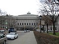
 The University of Pittsburgh's Alumni Hall
 -
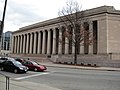
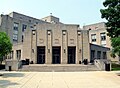
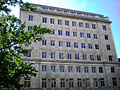
 The Pittsburgh Public Schools' Board of Education administration building
 -
![Panther Hollow Lake in Schenley Park[nb 1]](//upload.wikimedia.org/wikipedia/commons/thumb/c/c8/SchenleyPark1.JPG/120px-SchenleyPark1.JPG)
-
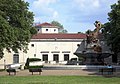
 Mellon Institute
 -
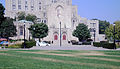
 Aerial view of Pittsburgh Public Schools' historic Schenley High School
 -
 Soldier and Sailors' Memorialon 5th Avenue in North Oakland
 -
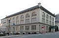
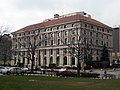 Pittsburgh Athletic Association, built 1909–1911, at the corner of Fifth Avenue and Bigelow Boulevard
 -
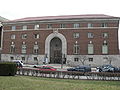 The former Y.M.H.A., is now Pitt's Bellefield Hall
 -
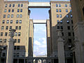 The formerSchenley Apartments, now Schenley Quadrangle residences at the University of Pittsburgh
 -
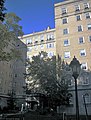
 The formerSchenley Hotel, now the University of Pittsburgh's William Pitt Union
 -
 Clapp Hall at the University of Pittsburgh
 -
 FormerMellon Institute building, now the University of Pittsburgh's Allen Hall
 -
 The former Ruskin Apartments, now the University of Pittsburgh's Ruskin Hall
 -
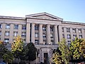
 The former National Union Fire Insurance Company building, now the University of Pittsburgh's Thackeray Hall
 -
 The Frick Fine Arts Building at the University of Pittsburgh
 -
 The former William Jacob Holland residence, now the Music Building at the University of Pittsburgh
 -
 The University Club, now a building on Pitt's campus
 -

-

-
 The Stephen Foster Memorial at the University of Pittsburgh
 -
 Dippy (sculpture)
 -
 Saint Nicholas Greek Orthodox Cathedral
 -
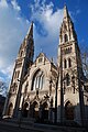 St. Paul's Cathedral
 -
-
 Bellefield Presbyterian Church
 -
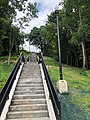
 The Louisa Street city steps (with bike runnel) in West Oakland. Photo by Laura Zurowski.
 -
 The Frazier Street city steps in South Oakland. Photo by Laura Zurowski.
 -
 The refurbished Joncaire Street city steps (with bike runnel) in Central Oakland.


![Phipps Conservatory & Botanical Gardens[nb 1]](/File:Phipps_conservatory.JPG)

![Hamerschlag Hall at Carnegie Mellon University[nb 1]](/File:CMU_Hamerschlag_Hall.jpg)


![Panther Hollow Lake in Schenley Park[nb 1]](/File:SchenleyPark1.JPG)


See also
- List of Pittsburgh neighborhoods
- Penn State University
- University City, Philadelphia – home to University of Pennsylvania
- Cecil B. Moore, Philadelphia – home to Temple University
Notes
References
- ^ a b c d e f g h i j "PGHSNAP 2010 Raw Census Data by Neighborhood". Pittsburgh Department of City Planning. 2012. Retrieved 21 June 2013.
- ^ "Oakland". Geographic Names Information System. United States Geological Survey, United States Department of the Interior. Retrieved July 15, 2022.
- ISBN 978-1-4930-1384-5.
- ^ "PGHSNAP – Neighborhoods: All Raw Data". Google Docs.
- ^ "Census:Pittsburgh" (PDF). Archived from the original (PDF) on August 10, 2007. Retrieved 2 September 2012.
- ^ "Pittsburgh Census Tracts". pitt.libguides.com. Retrieved January 2, 2018.
- ^ Wilhelm, Kathy (July 25, 1985), "Incubators help hatch new firms", Pittsburgh Post-Gazette, Pittsburgh, PA
- ^ Iati, Marisa (September 25, 2014). "Muslims in Islamic Center of Pittsburgh demonstrate little-known facets of their faith". Pittsburgh Post-Gazette. Retrieved October 31, 2018.
- ^ "Real estate plat-book of the city of Pittsburgh : from official records, private plans and actual surveys, Volume 1. Plate 15". G. M. Hopkins & Co. 1904. Retrieved 19 October 2011.
- ^ O'Neill, Brian (11 December 2011). "Can Pitt get SOUL (i.e., South Oakland Urban Litter)?". Pittsburgh Post-Gazette. Retrieved 11 December 2011.
- ^ CITY OF PITTSBURGH NEIGHBORHOOD PROFILES AMERICAN COMMUNITY SURVEY FIVE‐YEAR ESTIMATES 2005‐2009 DATA (PDF). PROGRAM IN URBAN AND REGIONAL ANALYSIS, UNIVERSITY CENTER FOR SOCIAL AND URBAN RESEARCH, UNIVERSITY OF PITTSBURGH. June 2011. Retrieved 11 June 2011.
- ^ Negley, W. B. (1876). "Allegheny County; its Formation, its Cities, Wards, Boroughs and Townships". Atlas of the County of Allegheny, Penna. Philadelphia: G.M. Hopkins & Co. p. 4.
- ^ "Teddy Roosevelt giving a speech in Pittsburgh | the Brady Stewart Collection".
- ^ "Moscow State University, Moscow, Russia". Emporis. Archived from the original on April 6, 2004. Retrieved 2 August 2010.
- ^ "Cathedral of Learning, Pittsburgh". SkyscraperPage.com. Retrieved 2012-12-07.
- ^ "The Pittsburgh Press – Google News Archive Search". news.google.com.
- ^ "St. George Orthodox Church |". www.sgcoakland.org. Retrieved 2022-07-11.
- ISBN 0-8229-5434-6.