
Oasisamerica
This article has multiple issues. Please help improve it or discuss these issues on the talk page. (Learn how and when to remove these template messages)
|

Oasisamerica is a
The term was first proposed by German-Mexican anthropologist
List of peoples
- Ak Chin, Arizona
- Southern Athabaskan
- Chiricahua Apache, New Mexico and Oklahoma
- Jicarilla Apache, New Mexico
- Lipan Apache, Texas
- Mescalero Apache, New Mexico
- Navajo (Navaho, Diné), Arizona and New Mexico
- San Carlos Apache, Arizona
- Tonto Apache, Arizona
- Western Apache(Coyotero Apache), Arizona
- White Mountain Apache, Arizona
- Taraname)
- Coahuiltecan, Texas, northern Mexico
- Cocopa, Arizona, northern Mexico
- ComecrudoTexas, northern Mexico
- Cotoname (Carrizo de Camargo)
- Halchidhoma, Arizona and California
- Hualapai, Arizona
- Havasupai, Arizona
- Hohokam, formerly Arizona
- Karankawa, Texas
- Kavelchadhom
- La Junta, Texas, Chihuahua
- Mamulique, Texas, northern Mexico
- Manso, Texas, Chihuahua
- Maricopa, Arizona
- Mojave, Arizona, California, and Nevada
- Pima, Arizona
- Pima Bajo
- Pueblo peoples, Arizona, New Mexico, Western Texas
- Ancestral Pueblo, formerly Arizona, Colorado, New Mexico, Utah
- Arizona Tewa, Hano), Arizona, joined the Hopi during the Pueblo Revolt
- Hopi, Arizona
- Keres people, New Mexico
- Acoma Pueblo, New Mexico
- Cochiti Pueblo, New Mexico
- Santo Domingo Pueblo), New Mexico
- Laguna Pueblo, New Mexico
- San Felipe Pueblo, New Mexico
- Santa Ana Pueblo, New Mexico
- Zia Pueblo, New Mexico
- Tewa people, New Mexico
- Nambé Pueblo, New Mexico
- San Juan Pueblo), New Mexico
- Pojoaque Pueblo, New Mexico
- San Ildefonso Pueblo, New Mexico
- Tesuque Pueblo, New Mexico
- Santa Clara Pueblo, New Mexico
- Tiwa people, New Mexico
- Isleta Pueblo, New Mexico
- Picuris Pueblo, New Mexico
- Sandia Pueblo, New Mexico
- Taos Pueblo, New Mexico
- Tigua Pueblo), Texas
- Piro Pueblo, New Mexico
- Towa people
- Walatowa), New Mexico
- Pecos (Ciquique) Pueblo, New Mexico
- Ashiwi), New Mexico
- Quechan (Yuma), Arizona and California
- Quems
- Solano, Coahuila, Texas
- Tamique
- Toboso
- Tohono O'odham, Arizona and Mexico
- Qahatika, Arizona
- Tompiro
- Ubate
- Walapai, Arizona
- Yoeme), Arizona, Sonora
- Yavapai, Arizona
- Tolkapaya(Western Yavapai), Arizona
- Yavapé(Northwestern Yavapai), Arizona
- Kwevkapaya(Southeastern Yavapai), Arizona
- Wipukpa(Northeastern Yavapai), Arizona
Geography
The term Oasisamerica combines "
Despite being a dry land, Oasisamerica contains several bodies of water like rivers:
Characteristics of the Oasisamerican cultures
Cultural development
The story of the origins of the cultural superarea of Mesoamerica takes place some 2,000 years after the cultural separation of Mesoamerica and Aridoamerica. Some of the Aridoamerican communities farmed as a complement to their hunter-gatherer economy. Those communities, including members of the Desert tradition, later would become more truly agricultural and form Oasisamerica.[9]

There are many indications of a close relationship between the two great cultural regions of North America. For one, the
Cultural areas
The area encompassed by Oasisamerica fostered the growth of several major cultural groups: the
.Ancestral Pueblo peoples

The Ancestral Pueblo is considered to be the most intensely studied
The Pueblo period begins with the development of

The reasons underpinning the decline of the Ancestral Pueblo remain somewhat of a mystery. The phenomenon is thought to be associated with a prolonged
The religion of the Pueblo Indians was based upon the worship of plant-like deities and the fertility of the earth. They believed that supernatural beings called the kachina had come to the surface of the Earth from the sipapu (center of the Earth) at the moment of the creation of the human race. Worship in Pueblo societies was organized by secret all-male groups that met in kivas. The members of these secret societies claimed to represent the kachina.[citation needed]
Hohokam

The Hohokam occupied the desert-like lands of
The principal settlements of the Hohokam culture were
Archaeologists dispute the origins and ethnic identity of the Hohokam culture. Some hold that the culture developed endogenously (without outside influence), pointing to Snaketown which had its origins in the fourth century BC. Others believe the culture to be a product of migration from Mesoamerica. In defense of this line of thought, proponents point to the fact that Hohokam ceramics appeared in 300 BC (also the time of Snaketown's founding), and that before this time, there was no indication of an independent regional development of ceramics. Along the same line of reasoning, several other technological advances like the canal works and certain cultural phenomena like cremation seem to have originated in western Mesoamerica.[18]
The development of the Hohokam culture is divided into four periods: Pioneer (300 BC–AD 550), Colonial (550–900), Sedentary (900–1100), and Classical (1100–1450). The Pioneer period commenced with the construction of the canal works. In the Colonial period, ties were strengthened with Mesoamerica. Proof of this can be found in the recovery of copper hawk bells,[19] pyrite mirrors,[20] and the construction of ball courts. The relations with Mesoamerica and the presence of such traded goods indicate that by the Colonial period the Hohokam had already become organized into chiefdoms. Relations with Mesoamerica would diminish in the following period, and the Hohokam turned to construct multi-story buildings like Casa Grande.[citation needed]
By the time the Europeans arrived in the Arizona and Sonora Deserts, a region which they named Pimería Alta, the urban centers of the Hohokam had already become abandoned presumably due to the health and ecological disasters that befell the indigenous social system. The
Mogollon

The Mogollon was a cultural area of Mesoamerica that extended from the foothills of the Sierra Madre Occidental, northward to Arizona and New Mexico in the southwestern United States. Some scholars prefer to distinguish between two broad cultural traditions in this area: the Mogollon itself and the Paquime culture that was derived from it. Either way, the peoples who inhabited the area in question adapted well to a landscape that was marked by the presence of pine forests and steep mountains and ravines.
In contrast to their Hohokam and Ancestral Pueblo neighbors to the north, the Mogollons usually buried their dead. The culture's graves often included ceramic art and semiprecious stones. Because the Mogollon burial sites displayed such wealth, they were often looted by grave robbers who sought to sell their spoils on the archaeological black market.[citation needed]
Perhaps the most impressive Mogollon ceramic tradition was to be found in the valley of the Mimbres River in New Mexico. The ceramic production of this region became most developed between the eighth and twelfth centuries. It was characterized by white pieces decorated with stylized representations of daily life in the community that created them. This was a very exceptional approach in a cultural area whose pottery was otherwise dominated by geometric patterns.[citation needed]
As another contrast with the Hohokam and Ancestral Pueblo, there is no widely accepted chronology for the development of the Mogollon culture. The scholars Alfredo López Austin and Leonardo López Luján, for their historical analysis of the region, borrowed a chronology proposed earlier by Paul Martin, who himself divided Mogollon history into two general periods; the "Early" period runs from 500 BC until AD 1000, and the "Late" period begins in the 11th and goes to the 16th century.[citation needed]
The first period featured a more or less slow cultural development. Technological changes were produced very gradually, and the form of social relationships and organizational patterns remained almost static for 1500 years. During the Early period, the Mogollons lived in rocky dwellings from which they defended themselves from the incursions of their hunter neighbors. Much like the Ancestral Pueblo peoples, the Mogollon also lived in semisubterranean abodes that often featured a kiva.[citation needed]
In the 11th century, the population in the Mogollon area multiplied much more rapidly than it had in the preceding centuries. During this period, the Mogollon likely benefited from trade relations with Mesoamerica, a fact that facilitated the development of agriculture and the stratification of society. It is also possible that Ancestral Pueblo influence could have grown at this time, because the Mogollon began to construct buildings of masonry, just like their northern neighbors.[citation needed]
The Mogollon culture reached its height in the 14th and 15th centuries. At this time, the culture's major centers grew in population, size, and power.
The decline of the main centers of Mogollon power began in the 13th century, even before the apex of Paquimé. By the 15th century, a large part of the region had become abandoned by its former inhabitants. Possible descendants of the Mogollon include the Tarahumara (Rarámuri) based in Chihuahua, the Hopi in Arizona, and the Zuni in New Mexico.[21]
Fremont
The Fremont area covered a large part of modern-day Utah. It was situated to the north of the Ancestral Pueblo cultural area. Its cultural development as a part of Oasisamerica took place between the 5th and 14th centuries. Scholars contend that the Fremont culture was derived from the Ancestral Pueblo culture. Theoretically, the Fremont communities would have emigrated toward the north, bringing with them the customs, social organization structures, and technology of the Ancestral Pueblo. This hypothesis neatly explains the presence of ceramics in Utah that are very similar to those found in Mesa Verde.[citation needed]
The decay of the Fremont culture began as early as the second half of the 10th century
Pataya
The Patayan area occupies the western part of Oasisamerica. It comprises the modern-day states of California and Arizona in the U.S., and Baja California and Sonora in Mexico. The Patayans were a peripheral culture whose cultural development was probably influenced by their Hohokam neighbors to the east. From them they would have learned the Mesoamerican ballgame, cremation techniques, and techniques for the production of ceramics.[citation needed]
The Patayan culture began to disappear in the 14th century. When the Spanish arrived in the region, the
-
 Mesa Verde
 -
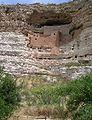 Montezuma's castle
 -
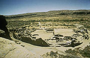 Chaco Canyon


See also
- Agriculture in the prehistoric Southwest
- History of Mesoamerica (Paleo-Indian)
- Mesoamerica
- Paleo-Indians
- List of dwellings of Pueblo peoples
- Southwestern archaeology
Notes
- ^ Kirchhoff, Paul (August 1954). "Gatherers and Farmers in the Greater Southwest: A Problem in Classification". American Anthropologist. 56 (4): 550. Retrieved December 24, 2023.
- ^ Carrasco, David (1997). Sullivan, Lawrence Eugene (ed.). Culture e religioni indigene in America centrale e meridionale (in Italian). Milan, Italy: Jaca Book-Massimo. pp. 222, 271. Retrieved December 24, 2023.
- ^ Alfredo López Austin and Leonardo López Luján, Mexico's Indigenous Past, p. 30.
- ^ a b Paul Kirchhoff, “Gatherers and Farmers in the Greater Southwest", p. 532.
- ^ Paul Kirchhoff, “Gatherers and farmers in the Greater Southwest: A problem in classification”, in American Anthropologist, 56 (1954) (Special Southwest Issue), pp. 529-550.
- .
- ^ Alfredo López Austin and Leonardo López Luján, Mexico's Indigenous Past, pp. 29–30.
- ^ The essence of anthropology, by William A. Haviland, Harald E. L. Prins, Dana Walrath, Bunny McBride
- ^ Mexico's Indigenous Past, By Alfredo López Austin, Leonardo López Luján, Bernard R. Ortiz De Montellano
- ^ a b c Alfredo López Austin and Leonardo López Luján, Mexico's Indigenous Past, p. 30.
- ^ Willis, W.H. (Winter 1999). "Bat Cave" (PDF). Archaeology Southwest. No. 13, n. 1. Center for Desert Archaeology. p. 13. Retrieved December 24, 2023.
- ^ Alfredo López Austin and Leonardo López Luján, Mexico's Indigenous Past, p. 258.
- ^ a b Minnis, Paul; Whalen, Michael (1993). "Casas Grandes: Archaeology in Northern Mexico". Expedition Magazine. 35 (1). Retrieved December 24, 2023.
- ^ Alfredo López Austin and Leonardo López Luján, Mexico's Indigenous Past, p. 29.
- ^ Archaeology of prehistoric native America: an encyclopedia, By Guy E. Gibbon, Kenneth M. Ames
- ^ World Regional Geography, By Joseph J. Hobbs, Andrew Dolan
- ^ Case studies in environmental archaeology, by Elizabeth Jean Reitz, C. Margaret Scarry, Sylvia J. Scudder
- ^ Alfredo López Austin and Leonardo López Luján, Mexico's Indigenous Past, p. 37.
- ^ Alfredo López Austin and Leonardo López Luján, Mexico's Indigenous Past, p. 31.
- ^ Alfredo López Austin and Leonardo López Luján, Mexico's Indigenous Past, p. 35.
- ISBN 9780816533169. Retrieved December 24, 2023.
- ^ ISBN 978-0-13-615686-4.
References
- Alfredo López Austin; Leonardo López Lujén (2005). Mexico's Indigenous Past. Norman: University of Oklahoma Press. ISBN 978-08061-3723-0. Retrieved December 23, 2023.
- Kirchhoff, Paul (August 1954). "Gatherers and Farmers in the Greater Southwest: A Problem in Classification". American Anthropologist. 56 (4): 529–50. Retrieved December 24, 2023.