
Ollagüe
| Ollagüe | |
|---|---|
Ultra | |
| Coordinates | 21°17′S 68°11′W / 21.283°S 68.183°W[2] |
| Naming | |
| Native name | Ullawi (Aymara) |
| Geography | |
 Ollagüe Location in Bolivia, on the border with Chile | |
| Location | El Loa Province, Chile |
| Parent range | Andes |
| Geology | |
| Age of rock | Pleistocene |
| Mountain type | Stratovolcano |
| Last eruption | 65,000 years ago[3] |
Ollagüe (Spanish pronunciation:
Ollagüe is mostly of
This phase of edifice growth was interrupted by a major collapse of the western flank of Ollagüe. Debris from the collapse spread in the form of hummocks down the western slope and into an adjacent
Name
The original Aymara name of the volcano was Ullawi. It is derived from Aymara ullaña to see, to look at, to watch, and wi which is a nominalizing suffix to indicate a place, thus "viewpoint".[4]
The common name is Ollagüe.[a] Other alternate names are Oyague, Ollagua and Oyahué.[1]
Geography and geomorphology
Ollagüe straddles the border between
Regional
Ollagüe is part of the
The CVZ is located between 16° and 28° southern latitude, on the western margin of
The Central
Local
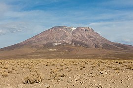
Ollagüe is a stratovolcano and lies isolated slightly east of the main volcanic arc.[2] The volcano is usually covered with snow, which together with yellow and red colours gives Ollagüe a "beautiful" appearance.[16] Other than some past glacial activity, the arid climate of the Altiplano region has kept erosion rates low, meaning that the volcanic edifice is well preserved.[30] On the other hand, lack of erosion also means that relatively little of its internal structure is exposed.[31]
Ollagüe has two summits, Ollagüe South is 5,868 metres (19,252 ft) high and Ollagüe North 5,863 metres (19,236 ft).
-
 Ollagüe summit from Bolivia
 -
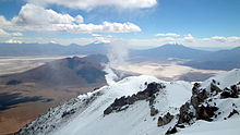 View from the summit of Ollagüe to southwest
.jpg)
.jpg)

The volcano has a number of
A 700 metres (2,300 ft) wide
Older volcanic centres around Ollagüe are Cerro Chijliapichina southwest (also known as Cerro Peineta[36]), Cerro Canchajapichina south and Wanaku east of the volcano. These centres are unrelated to Ollagüe and were deeply affected by glaciation.[30] On the eastern foot the Carcote ignimbrite crops out,[9] a 5.9–5.5 million years old ignimbrite that is part of the Altiplano–Puna volcanic complex. These ignimbrites form the basement in much of the region.[2] The Carcote ignimbrite originally formed a plateau that extended around the volcano.[44] Off the western foot of Ollagüe lies a smaller volcanic centre that forms an effusive shield.[27]

The Salar de Ollague is located due north, while the Salar de San Martin lies southwest and Salar de Chiguana northeast of Ollagüe.[9] They are situated at elevations of 3,690–3,694 metres (12,106–12,119 ft).[32] The Salar de San Martin and the Salar de Ascotán farther south form a northwest–southeast trending graben delimited by the same normal fault that crosses the edifice of Ollagüe.[36] A ring plain formed by debris shed from Ollagüe surrounds the volcano.[45]
Glaciation
Presently, high
Ollagüe has experienced
Debris avalanche
A major
The younger debris avalanche deposit has a volume of about 1 cubic kilometre (0.24 cu mi). It was believed that it occurred about 600,000–400,000 years
Andesitic
The sector collapse was probably caused by the edifice oversteepening as it grew,[62] with Ollagüe reaching a critical height before the collapse.[63] Magma pressurization probably triggered the failure, as the remnants of a lava lake in its summit indicate that magma pressure in the edifice was high at the time of the collapse. Conversely, hydrothermal alteration – which tends to weaken the stability of a volcanic edifice – was not involved in the onset of instability.[64] The northwest–southeast cutting fault probably additionally destabilized the edifice, allowing it to fail into a southwestern direction.[65] A previous southwesterly tilt of the basement also assisted in focusing the failure into that direction.[66]
The sector collapse formed a 3.5 kilometres (2.2 mi) wide collapse scar on the upper western flank,[2] although the summit itself was probably unaffected.[57] This scar however was later filled by subsequent volcanic activity and modified by glaciation and is thus not conclusively identifiable.[2]
Two old sector collapses occurred during the older stages of volcanic activity. Their collapse scars are noticeable on the southeastern-southern and northwestern areas of the summit. The first is 400 metres (1,300 ft) high and 1,500 metres (4,900 ft) long, the second 4,000 metres (13,000 ft) long and many 10 metres (33 ft) high. Hydrothermally altered breccia with block sizes of several 0.1–1 metre (3.9 in – 3 ft 3.4 in) from the first collapse fills a valley on the western slope of the volcano.[39] Compared to the younger collapse, they are much narrower and have a highly unusual rectilinear form.[67] These collapses occurred about 450,000 years ago along the strike of a normal fault that cuts across Ollagüe.[41] Like in the young collapse, the summit was unaffected.[64] The lava domes that form the western rim of the summit crater have been subject to smaller sector collapses as well.[14]
-

-
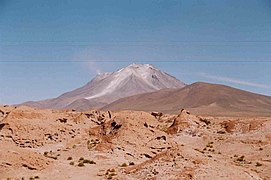
 Fumarole clearly visible
 -
-

-
-
 Panoramic image, with Ollagüe in the centre


Composition
Ollagüe has erupted rocks ranging from
Overall, the composition of Ollagüe's rocks fits into a high-
.jpg)
Areas of
The overall magma temperatures ranged 825–1,000 °C (1,517–1,832 °F) for the andesitic and dacitic magmas and 1,010–1,060 °C (1,850–1,940 °F) in the basaltic andesite.[71] The magmas became cooler over time, with the post-collapse magmas being colder than the pre-collapse eruptive products.[72] Variations in temperature between the outside and the inside of phenocrysts suggest that the magma chamber of Ollagüe was occasionally reheated by fresh magmas.[71] Water contents of the main edifice magmas range 3-5% by weight; in the Ch'aska Urqu and La Celosa magmas the water content is less well determined,[73] but is comparable to that of the main edifice magmas.[74] Later research, however, has raised questions about the reliability of the method used to determine water content in magma, which may have been lower than 3–5%.[75]
Element compositions match those of other volcanoes in the CVZ.
The composition data indicate that Ollagüe was underpinned by a large magma chamber that was the source of the main edifice building andesite magmas.[81] In this main magma chamber, differentiation processes generated the andesitic and dacitic magmas from basaltic andesite. The chamber itself was chemically zoned.[82] Episodically, new mafic magmas were injected into the magma chamber from below.[83] Subsidiary magma chambers which developed beneath the northwestern and southeastern flank gave rise to the La Celosa and Ch'aska Urqu volcanic centres, respectively. These subsidiary pathways also allowed basaltic andesite magmas to ascend to the surface; the main magma chamber would have intercepted any mafic magmas ascending into the central vent as such mafic magmas are denser.[81] The walls of the magma chamber were also affected by strong hydrothermal alteration processes, with weaker alteration also occurring in the walls of the subsidiary magma chambers.[84] La Poruñita was probably formed by magmas from the floor of the main magma chamber, or from the magma that enters the magma chamber from below; it had already undergone some crustal contamination in the depths of the crust when it erupted.[85]
Fumarolic activity
A major fumarole is active on the summit of the volcano, its plume reaching heights of 100 metres (330 ft).[51] It is strong enough that it can be seen on the ground from over 10 kilometres (6.2 mi) away.[86] The vent of the fumarole lies in the summit lava domes,[51] more specifically in a 200 metres (660 ft) high and 350 metres (1,150 ft) wide collapse scar in the southeasternmost lava dome of the compound summit lava dome.[35] Other volcanoes in the area with fumarolic activity include San Pedro and Putana.[87]
Fumarole temperatures appear to be so low (less than 100 °C (212 °F)) that in 1989 the exhalations could not be detected in the
Fumarolic gases are made up primarily by SO
2 and H
2O; CO
2 is a subordinate component.[13] The amounts of SO
2 released have been measured; quantities vary but in December 2013 appeared to be about 150 ± 162 tonnes per day (1.74 ± 1.88 kg/s).[90]
Eruption history
Not many radiometric dates have been obtained on Ollagüe. Most dates are younger than one million years.[2] One proposed timeline subdivides the volcano into three stages: Ollagüe I between 1.2 million and 900,000 years ago, Ollagüe II 900,000–600,000 years ago and Ollagüe III 400,000 years ago to present.[38] La Poruñita, once considered of Holocene age,[1] has been dated at 680,000 ± 200,000 to 420,000 ± 200,000 years ago;[43] it is also not clear if it belongs to the Ollagüe volcanic system.[51] Magma output during the history of the volcano is about 0.09 cubic kilometres per millennium (0.0029 m3/s).[91]
Vinta Loma and Santa Rosa
The oldest stage of activity is known as Vinta Loma and formed the bulk of the volcanic edifice, especially on the eastern side and in the summit area.
Lava flows from these stages have gray colours and rocky appearance which sometimes appears like it is covered by plates, with flow folds and some breccia. Their thicknesses and widths range 20–90 metres (66–295 ft), increasing on gentler slopes. Especially on the upper slopes, old colluvium conceals the surface of Vinta Loma lava flows.[92] The texture of the lavas ranges from porphyritic to seriate.[93] Two-pyroxene andesite is the dominant component but dacite has been found as well.[2]
The Vinta Loma edifice developed on top of an older fault. During the progression of volcanism the fault itself progressively propagated up and across the edifice and caused the southwest sector of the volcano to subside, without changes in volcanic activity. Eventually, the subsidence prevented lava flows of the Santa Rosa series from flowing northeast across the fault trace.[95] Then, the two older sector collapses occurred on the southwestern sides of the fault.[96]
Ch'aska Urqu, El Azufre and La Celosa series
Later the Ch'aska Urqu stage was erupted on top of Vinta Loma deposits
About 10 lava andesitic-dacitic domes and coulees were erupted on top of the basaltic andesite lava flows. They are short and have steep slopes, often ending with scree at the front. On the foot of the volcano they sometimes developed pressure ridges, and a 80 metres (260 ft) deep cleft in Ch'aska Urqu may have formed when the dome spread laterally during its formation.[98] As with Vinta Loma lavas,[92] the upper parts of the coulees are covered with thin colluvium.[98]
Simultaneously, another dacitic lava dome stage occurred on the northwestern flank, forming the La Celosa lava dome-coulee complex.
The andesites and dacites are of grey to light grey colour respectively, with porphyritic to
Later evidence has indicated that some lava flows were erupted from the summit during the Ch'aska Urqu stage. Also, a structure interpreted as a former lava lake formed close to the summit during this time. The lava lake-like structure itself is undated; one of the lava flows was dated 410,000 ± 80,000 years ago and the southern summit cinder cone is 292,000 ± 25,000 years old. This series is known as El Azufre.[94] The El Azufre series was emplaced within a sector collapse, a collapse which generated pyroclastic deposits in the Poroto section of the southwestern flank.[95]
- Ollagüe from the town of the same name, the La Celosa lava domes are in the foreground
-

-


Post-collapse and Santa Cecilia series
The principal sector collapse occurred after the Ch'aska Urqu stage. It was followed by the eruption of andesitic
The lava flows are best exposed on the western flank and have a grey colour. They display levees and pressure ridges and appear to be younger than the Ch'aska Urqu flows.[57] They originate at elevations of 4,800 metres (15,700 ft) and extend over distances of 4.5 kilometres (2.8 mi).[35] The summit lava dome has a volume of 0.35 cubic kilometres (0.084 cu mi);[57] blocks with sizes of up to 10 metres (33 ft) were formed by landslides during its growth.[34] Later research has shown that the summit lava dome is actually formed by several separate lava domes that extend southeast along a feeder fissure and become younger to the southeast. The foot of the compound dome is formed by scree-like breccia deposits.[35]
Compositionally, the post-collapse magmas appear to fit into two distinct groups. Older flows are dominated by pyroxene with only small quantities of amphibole and biotite. Younger shorter flows farther up on the edifice and the summit lava dome conversely contain relatively large quantities of amphibole and biotite.[51]
Recent activity and hazards
The post-collapse lava flows have been affected by
An uncertain report of an eruption on 3 December 1903 exists,
The volcano is considered to be potentially active because of the fumarolic activity,
Sulfur mining and processing
Sulfur deposits on Ollague and neighbouring Aucanquilcha[107] have been mined, with the Santa Cecilia mine located on the northwestern rim and the Santa Rosa mine in the centre of the crater.[14] In 1990, it was estimated that 3,000,000 tonnes (3,000,000 long tons; 3,300,000 short tons) of sulfur can be mined at the Santa Rosa mine.[11] According to a report in 1894, fumes released from sulfur beds on the volcano can incapacitate a man in seconds, making ascents difficult.[16]
Large-scale exploitation of natural resources in the area commenced in the late 19th century, when after the
A road reaching up to an altitude of 5,500 metres (18,000 ft) leads to the western and southern mines.
Mining activity at Ollagüe is mostly documented by many
Sulfur mining was mostly carried out by an indigenous workforce,
See also
Notes
- ^ The ll in classical Spanish corresponds to the sound [ʎ] which matches the Aymara pronunciation (though today most Spanish speakers pronounce it [ʝ]).[5] The g in the name was inserted because using an intervocalic [w] consonant is foreign to classical Spanish[6] and the closest approximation is [ɣw] (gü). The rendering of the vowels as o and e rather than u and i derives from the fact that Andean languages (including Aymara) generally do not distinguish between the vowel sounds [o] and [u], as well as [e] and [i], so the precise sounds can vary by speaker.[7][8]
- ^ A monogenetic volcano is a volcano that has only one defined eruption event.[28] They often appear in groups.[29]
- ^ a b A reaction rim is a mineral phase that develops around a grain of another mineral, typically as a consequence of alterations of the grain-forming mineral.[69]
- lava flow.[97]
References
- ^ a b c d e f g h i "Ollague". Global Volcanism Program. Smithsonian Institution.
- ^ a b c d e f g h i j k l m n o Feeley & Davidson 1994, p. 1298.
- ^ a b Renzulli, Alberto; Tibaldi, Alessandro; Flude, Stephanie (August 2006). "NEW DATA OF SURFACE GEOLOGY, PETROLOGY AND Ar-Ar GEOCHRONOLOGY OF THE ALTIPLANO-PUNA VOLCANIC COMPLEX (NORTHERN CHILE) IN THE FRAMEWORK OF FUTURE GEOTHERMAL EXPLORATION" (PDF). 11th Chilean Geological Congress. Archived from the original (PDF) on November 25, 2015.
- ^ Radio San Gabriel, "Instituto Radiofonico de Promoción Aymara" (IRPA) 1993, Republicado por Instituto de las Lenguas y Literaturas Andinas-Amazónicas (ILLLA-A) 2011, Transcripción del Vocabulario de la Lengua Aymara, P. Ludovico Bertonio 1612 (Spanish-Aymara-Aymara-Spanish dictionary)
- S2CID 170911379.
- ISBN 9789027248190.
- ISBN 9789004284005.
- ISBN 9780292789807.
- ^ a b c d e Feeley & Davidson 1994, p. 1297.
- ^ SERNAGEOMIN (in Spanish). Archived from the originalon December 15, 2017. Retrieved 17 January 2018.
- ^ a b c d e Long, Keith R. (1990). "Volcan Ollague Mines". mrdata.usgs.gov.
- ^ a b Shea & Vries 2008, p. 666.
- ^ SERNAGEOMIN (in Spanish). Archived from the originalon 17 January 2018.
- ^ a b c d e f g Vezzoli et al. 2008, p. 140.
- ISBN 978-0-89886-495-3.
- ^ JSTOR 1774025.
- ISSN 1811-5209.
- ^ a b c d e f Feeley & Davidson 1994, p. 1296.
- ^ ISSN 0012-821X.
- ^ Mattioli et al. 2006, p. 88.
- ^ a b c d Vezzoli et al. 2008, p. 139.
- S2CID 4416832.
oceanic Nazca plate and the continental South America plate
- ^ a b Feeley & Sharp 1995, p. 241.
- ^ a b c Feeley, Davidson & Armendia 1993, p. 223.
- ^ Tamburello et al. 2014, p. 4961.
- ^ Feeley, Davidson & Armendia 1993, p. 222.
- ^ a b Mattioli et al. 2006, p. 89.
- ^ Németh & Kereszturi 2015, p. 2133,21341.
- ^ Németh & Kereszturi 2015, p. 2131.
- ^ a b c Feeley, Davidson & Armendia 1993, p. 224.
- ^ Feeley, Davidson & Armendia 1993, p. 225.
- ^ a b Vezzoli et al. 2008, p. 142.
- ^ a b Knoche 1932, p. 100.
- ^ a b c d Feeley, Davidson & Armendia 1993, p. 230.
- ^ a b c d Vezzoli et al. 2008, p. 149.
- ^ a b c Vezzoli et al. 2008, p. 146.
- ^ Feeley, Davidson & Armendia 1993, p. 234.
- ^ a b c Vezzoli et al. 2008, p. 144.
- ^ a b c d e Vezzoli et al. 2008, p. 148.
- ^ Vezzoli et al. 2008, p. 155.
- ^ a b Tibaldi et al. 2008, p. 154.
- ^ Tibaldi et al. 2008, p. 167.
- ^ ISSN 0716-0208.
- ^ Vezzoli et al. 2008, p. 145.
- S2CID 133834335.
- ^ a b Knoche 1932, p. 101.
- ^ Baschin 1934, p. 63.
- ^ ISSN 0022-1430.
- ^ Baschin 1934, p. 64.
- ^ a b c d Feeley & Davidson 1994, p. 1299.
- ^ a b c d e f g h i Feeley, Davidson & Armendia 1993, p. 231.
- ^ a b c Francis & Wells 1988, p. 267.
- ^ a b Francis & Silva 1989, p. 251.
- ^ Shea & Vries 2008, p. 683.
- ^ a b Francis & Wells 1988, p. 265.
- ^ Shea & Vries 2008, p. 663.
- ^ a b c d e f Feeley, Davidson & Armendia 1993, p. 229.
- ^ a b c Vezzoli et al. 2008, p. 151.
- ^ Vezzoli et al. 2008, p. 143.
- ^ Francis & Silva 1989, pp. 250, 251.
- ^ Vezzoli et al. 2008, p. 150.
- ^ Feeley, Davidson & Armendia 1993, p. 242.
- ^ Tibaldi et al. 2008, p. 170.
- ^ a b Vezzoli et al. 2008, p. 154.
- ^ a b Tibaldi et al. 2008, p. 169.
- ^ Tibaldi et al. 2008, p. 168.
- ^ Vezzoli et al. 2008, pp. 152, 153.
- ^ a b Feeley, Davidson & Armendia 1993, p. 232.
- ISBN 978-0-442-20623-9.
- ^ Feeley & Davidson 1994, p. 1302.
- ^ a b Feeley & Davidson 1994, p. 1309.
- ^ Feeley & Davidson 1994, p. 1310.
- ^ Feeley & Davidson 1994, p. 1312.
- ^ Feeley & Davidson 1994, p. 1313.
- ISSN 0022-3530.
- ^ Feeley & Davidson 1994, p. 1322.
- ^ Feeley & Sharp 1995, p. 240.
- ^ Feeley & Sharp 1995, p. 248.
- ^ Feeley & Davidson 1994, p. 1326.
- ^ Feeley, Davidson & Armendia 1993, p. 243.
- ^ a b Feeley & Davidson 1994, p. 1329.
- ^ Feeley & Davidson 1994, p. 1330.
- ^ Feeley & Davidson 1994, p. 1332.
- ^ Feeley & Sharp 1995, p. 250.
- ^ Mattioli et al. 2006, p. 101.
- ^ S2CID 129450763.
- ^ Rudolph 1951, p. 112.
- ^ Francis & Silva 1989, p. 247.
- ^ Pritchard et al. 2014, p. 92.
- ^ Tamburello et al. 2014, p. 4964.
- S2CID 140668081.
- ^ a b c Feeley, Davidson & Armendia 1993, p. 226.
- ^ a b c Feeley, Davidson & Armendia 1993, p. 227.
- ^ a b c d e Vezzoli et al. 2008, p. 141.
- ^ a b Vezzoli et al. 2008, p. 152.
- ^ Vezzoli et al. 2008, p. 153.
- ISBN 978-3-642-74381-8.
- ^ a b c d Feeley, Davidson & Armendia 1993, p. 228.
- S2CID 214198721.
- ^ Feeley & Davidson 1994, pp. 1298, 1299.
- ^ Vezzoli et al. 2008, pp. 149, 150.
- ^ Tamburello et al. 2014, p. 4962.
- .
- ^ Pritchard et al. 2014, p. 101.
- ^ Pritchard et al. 2014, p. 98.
- ^ Pritchard et al. 2014, p. 91.
- ^ a b Rivera 2018, p. 89.
- ^ Rivera 2018, p. 94.
- ^ a b c Rivera 2018, p. 90.
- ^ Rivera 2018, p. 102.
- ^ a b c Rivera, Lorca & González 2018, p. 12.
- ^ Rudolph 1951, p. 104.
- ^ Rivera, Lorca & González 2018, p. 16.
- ^ a b Rivera 2018, p. 91.
- ^ Rivera 2018, p. 108.
- ^ Rivera, Lorca & González 2018, p. 13.
- ^ a b Rivera 2018, p. 88.
- ^ Rivera 2018, p. 87.
- ^ Rivera 2018, pp. 96–97.
- ^ Rivera 2018, p. 99.
- ^ Rivera 2018, p. 101.
Sources
- Baschin, O. (January 1934). "Geographische Mitteilungen". Die Naturwissenschaften (in German). 22 (4): 62–64. S2CID 20425799.
- Feeley, T. C.; Davidson, J. P. (1994-10-01). "Petrology of Calc-Alkaline Lavas at Volcan Ollag e and the Origin of Compositional Diversity at Central Andean Stratovolcanoes". Journal of Petrology. 35 (5): 1295–1340. ISSN 0022-3530.
- Feeley, Todd C.; Davidson, Jon P.; Armendia, Adolfo (1993). "The volcanic and magmatic evolution of Volcán Ollagüe, a high-K, late quaternary stratovolcano in the Andean Central Volcanic Zone". .
- Feeley, T.C.; Sharp, Z.D. (1995). "18O16O isotope geochemistry of silicic lava flows erupted from Volcán Ollagüe, Andean Central Volcanic Zone". Earth and Planetary Science Letters. 133 (3–4): 239–254. .
- Francis, P.W.; Silva, S.L. De (April–June 1989). "Application of the Landsat Thematic Mapper to the identification of potentially active volcanoes in the central Andes". Remote Sensing of Environment. 28: 245–255. .
- Francis, P. W.; Wells, G. L. (1988-07-01). "Landsat Thematic Mapper observations of debris avalanche deposits in the Central Andes". Bulletin of Volcanology. 50 (4): 258–278. S2CID 128824938.
- Mattioli, Michele; Renzulli, Alberto; Menna, Michele; Holm, Paul M. (2006-11-01). "Rapid ascent and contamination of magmas through the thick crust of the CVZ (Andes, Ollagüe region): Evidence from a nearly aphyric high-K andesite with skeletal olivines". Journal of Volcanology and Geothermal Research. Interaction between volcanoes and their basement. 158 (1–2): 87–105. .
- Németh, K.; Kereszturi, G. (1 November 2015). "Monogenetic volcanism: personal views and discussion". S2CID 126749618.
- Knoche, Walter (1932). "Verdunstungseis auf dem Anden-Vulkan Oyahue". Z. Gletscherkunde (in German). 20: 101–102.
- Pritchard, M. E.; Henderson, S. T.; Jay, J. A.; Soler, V.; Krzesni, D. A.; Button, N. E.; Welch, M. D.; Semple, A. G.; Glass, B. (2014-06-01). "Reconnaissance earthquake studies at nine volcanic areas of the central Andes with coincident satellite thermal and InSAR observations". Journal of Volcanology and Geothermal Research. 280: 90–103. .
- Rivera, Francisco (2018). "Cicatrices materiales y espacios industriales en Ollagüe, norte de Chile". Revista de Arqueología Americana (in Spanish) (36): 85–118. ISSN 2663-4066.
- Rivera, Francisco; Lorca, Rodrigo; González, Paula (1 June 2018). "Post-preservación industrial en Ollagüe: un breve elogio de la decadencia". Boletín de la Sociedad Chilena de Arqueología (in Spanish): 9–29. ISSN 0716-5730.
- Rudolph, William E. (1951-01-01). "Chuquicamata Twenty Years Later". Geographical Review. 41 (1): 88–113. JSTOR 211310.
- Shea, Thomas; Vries, Benjamin van Wyk de (2008-08-01). "Structural analysis and analogue modeling of the kinematics and dynamics of rockslide avalanches". Geosphere. 4 (4): 657–686. ISSN 1553-040X.
- Tamburello, G.; Hansteen, T. H.; Bredemeyer, S.; Aiuppa, A.; Tassi, F. (2014-07-28). "Gas emissions from five volcanoes in northern Chile and implications for the volatiles budget of the Central Volcanic Zone" (PDF). Geophysical Research Letters. 41 (14): 2014GL060653. ISSN 1944-8007.
- Tibaldi, Alessandro; Corazzato, Claudia; Kozhurin, Andrey; Lagmay, Alfredo F. M.; Pasquarè, Federico A.; Ponomareva, Vera V.; Rust, Derek; Tormey, Daniel; Vezzoli, Luigina (2008-04-01). "Influence of substrate tectonic heritage on the evolution of composite volcanoes: Predicting sites of flank eruption, lateral collapse, and erosion". Global and Planetary Change. 61 (3–4): 151–174. .
- Vezzoli, Luigina; Tibaldi, Alessandro; Renzulli, Alberto; Menna, Michele; Flude, Stephanie (2008-03-30). "Faulting-assisted lateral collapses and influence on shallow magma feeding system at Ollagüe volcano (Central Volcanic Zone, Chile-Bolivia Andes)". Journal of Volcanology and Geothermal Research. 171 (1–2): 137–159. .
External links
- Population data and map of San Pedro de Quemes Municipality
- "Ollagüe". Peakware.com. Archived from the original on 2016-03-04.
- AVA