Orange Free State (province)
(Redirected from
Orange Free State Province
)| Province of the Orange Free State Provinsie Oranje-Vrystaat ( Afrikaans) | |||||||||
|---|---|---|---|---|---|---|---|---|---|
| Province of South Africa | |||||||||
| 1910–1994 | |||||||||
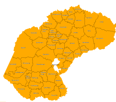
 The OFS as it was by 1994 | |||||||||
| Capital | Bloemfontein | ||||||||
| Area | |||||||||
• 1991 | 129,825 km2 (50,126 sq mi) | ||||||||
| Population | |||||||||
• 1991 | 2,193,062[1] | ||||||||
| • Type | Orange Free State Provincial Council | ||||||||
| History | |||||||||
• Established | 31 May 1910 | ||||||||
• Disestablished | 27 April 1994 | ||||||||
| |||||||||
| Today part of | South Africa | ||||||||
The Province of the Orange Free State (
Free State Province
.
Its predecessor was the Orange River Colony which in 1902 had replaced the Orange Free State, a Boer republic.
Its outside borders were the same as those of the modern
Bophuthatswana
, which were contained on land inside of the provincial Orange Free State borders.
Districts in 1991
Districts of the province and population at the 1991 census.[1]

- Zastron: 14,122
- Rouxville: 11,904
- Bethulie: 9,333
- Smithfield: 7,946
- Wepener: 12,964
- Dewetsdorp: 13,521
- Reddersburg: 6,070
- Edenburg: 6,968
- Trompsburg: 5,138
- Jagersfontein: 6,353
- Bloemfontein: 300,150
- Petrusburg: 11,071
- Brandfort: 23,521
- Botshabelo: 177,926
- Philippolis: 7,056
- Fauresmith: 8,916
- Koffiefontein: 10,778
- Jacobsdal: 9,748
- Boshof: 32,033
- Theunissen: 38,482
- Bultfontein: 28,556
- Hoopstad: 27,934
- Wesselsbron: 26,494
- Odendaalsrus: 97,603
- Welkom: 248,186
- Virginia: 81,780
- Hennenman: 25,165
- Ventersburg: 14,534
- Ladybrand: 30,532
- Excelsior: 18,051
- Clocolan: 18,542
- Marquard: 17,217
- Winburg: 17,765
- Senekal: 41,551
- Ficksburg: 36,810
- Fouriesburg: 16,932
- Bethlehem: 80,921
- Lindley: 37,664
- Reitz: 30,712
- Harrismith: 63,220
- Vrede: 37,324
- Kroonstad: 110,963
- Bothaville: 54,726
- Viljoenskroon: 59,279
- Vredefort: 13,518
- Koppies: 19,723
- Parys: 48,678
- Sasolburg: 89,079
- Heilbron: 40,987
- Frankfort: 44,617
Administrators
See also
- Orange Free State
- Free State (South African province)
References
- ^ a b "Census > 1991 > RSA > Variable Description > Person file > District code". Statistics South Africa – Nesstar WebView. Archived from the original on 19 June 2016. Retrieved 18 August 2013.


