
Orla Perć
| Orla Perć | |
|---|---|
 Trail blazing | |
| Length | 4.5 km (2.8 mi) |
| Location | Tatra Mountains, Poland |
| Trailheads | Zawrat Pass 49°13′09″N 20°00′59″E / 49.219111°N 20.016417°E Krzyżne Pass 49°13′43″N 20°02′50″E / 49.228694°N 20.047331°E |
| Use | Climbing |
| Highest point | Kozi Wierch 2,291 metres (7,516 ft) |
| Season | Preferably in summer |
| Hazards | Falling stones, avalanches |
49°13′06″N 20°01′43″E / 49.21833°N 20.02861°E Orla Perć (English: Eagle's Path) is a tourist path in the Tatra Mountains in southern Poland. It is considered one of the most difficult and dangerous public paths in the entire Tatras (an equivalent to Grade 2 Scramble)[1] and is therefore a suitable route only for experienced climbers. The path is marked with red signs. Since it was established in the early 20th century, at least 112 people have lost their lives on the route.[2]
Technical data
The route is located in the centre of the
History
The path was conceived in 1901, the brainchild of Franciszek Nowicki, a Polish poet and mountain guide. The route was partially funded, constructed and marked by Fr. Walenty Gadowski between 1903 and 1906 with the aid of a few locals; however, the junctions and other auxiliary routes were led and marked by 1911.[6] After several fatal accidents, in 2006 a mountain guide Irena Rubinowska and Piotr Mikucki, a film director, launched an appeal to the authorities of the Tatra National Park to dismount all climbing aids along the path and change it to via ferrata.[7] The appeal met with different reactions from groups and professional lobbies involved in the tourist business. It was concluded that this is a historic trail, and will remain unchanged. As many accidents took place when passing in the opposite direction, the TPN Directorate has introduced one-way traffic at the most difficult section of Orla Perć from Zawrat to Kozi Wierch in July 2007.[citation needed]
Gallery
-
 Descent through The Honoratka Couloir
 -
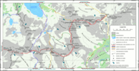 Map of the path
 -
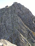
 The path descends from Kozie Czuby
 -
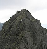
 The path on Kozi Wierch
 -
 Climbing aids on the path
 -
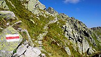 Rare easily hikeable fragment


See also
- Tatra Volunteer Search and Rescue
- Tourism in Poland
References
- ISBN 83-89188-50-3
- ^ Orla Perć – wypadki i akcje ratownicze (retrieved 15 November 2009)
- ^ Zabójcza Orla Perć?
- ^ Tatry: Orla Perć (retrieved 15 November 2009)
- ^ Orla Perć Archived 20 November 2009 at the Wayback Machine (retrieved 25/11/08)
- ISBN 83-7104-009-1.
- ^ Juliusz Wysłouch "Via ferraty dla tatr Wysokich, "Na szlaku" 10/2003