
Orongo

Orongo (
The first half of the ceremonial village's 53 stone masonry houses was investigated and restored in 1974, with the remainder completed in 1976 and subsequently investigated in 1985 and again in 1995. Orongo now has World Heritage status as part of the Rapa Nui National Park.
History
69 Between the 18th and mid-19th centuries Orongo was the centre of a
In the 1860s, most of the
The site of Orongo was included in the 1996 World Monuments Watch by the World Monuments Fund, and listed again four years later, in 2000. The threat was soil erosion, caused by rainfall and exacerbated by foot traffic.[1] After 2000, the organization helped devise a site management plan with support from American Express, and in December 2009 more funding was announced for the construction of a sustainable visitor center.[2]
-
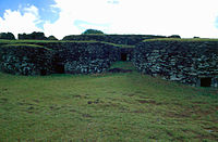 Restored stone houses at Orongo
 -

-


See also
References
Resources
- Mulloy, William. Investigation and Restoration of the Ceremonial Center of Orongo. International Fund for Monuments Bulletin No. 4. New York (1975).
- Mulloy, W.T., and S.R. Fischer. 1993. Easter Island Studies: Contributions to the History of Rapanui in Memory of William T. Mulloy. Oxford: Oxbow Books.
- ISBN 0-932813-48-8(1998 US reprint)
External links
- (in Spanish) Official Site for Rapa Nui National Park
- Rapa Nui National Park – UNESCO World Heritage Centre
- Photos of location, Birdman and houses
- Hoa Hakananai'a at the British Museum
27°11′22″S 109°26′33″W / 27.18944°S 109.44250°W
| Culture |
|  | ||||
|---|---|---|---|---|---|---|
| Geography and geology | ||||||
| Administration |
| |||||
| ||
| International | |
|---|---|
| National | |