
Oualata
Oualata
Hodh Ech Chargui | |
|---|---|
| Population (2013 census)[1] | |
| • Total | 13,086 |
Arab States | |
Oualata or Walata (
History
The Oualata area is believed to have been first settled by an agro-pastoral people akin to the
The town formed part of the Ghana Empire and grew wealthy through trade. At the beginning of the thirteenth century Oualata replaced Aoudaghost as the principal southern terminus of the trans-Saharan trade and developed into an important commercial and religious centre.[4] By the fourteenth century the city had become part of the Mali Empire.
An important trans-Saharan route began at Sijilmasa and passed through Taghaza with its salt mines and ended at Oualata. The French historian Raymond Mauny estimated that in the Middle Ages the town would have accommodated between 2000 and 3000 inhabitants.[5]
Moroccan explorer Ibn Battuta found the inhabitants of Oualata were Muslim and mainly Massufa, a section of the Sanhaja. He was surprised by the great respect and independence that women enjoyed. He only gives a brief description of the town itself: "My stay at Iwalatan (Oualata) lasted about fifty days; and I was shown honour and entertained by its inhabitants. It is an excessively hot place, and boasts a few small date-palms, in the shade of which they sow watermelons. Its water comes from underground waterbeds at that point, and there is plenty of mutton to be had."[6] The town's original Mande name Biru had already shifted to the Berber Iwalatan, a reflection of the changing identity of the residents. This would change again with the town's Arabization, and the development of the current name, Walata.[7]
From the second half of the fourteenth century
Description
The old town covers an area of about 600 m by 300 m, some of it now in ruins.
Gallery
-
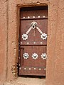
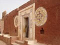 Oualata Decorative Entrance
 -
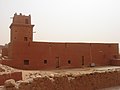 Oualata Mosque
 -
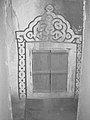 Oualata Decorative Window
 -
 Oualata Decorative Secondary Entrance
 -
 Oualata Decorative Secondary Entrance
 -
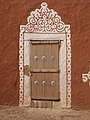
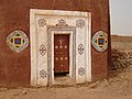 Oualata Decorative Main Entrance
 -
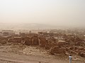
 View of Oualata 1
 -
 View of Oualata 2
 -
 View of Oualata 3
 -
 View of Oualata 4


See also
- Twelve Doors of the Mali Empire
- En attendant les hommes, 2007 documentary film about women muralists in Oualata.
- Mauritania: Oualata, “the big sister of Timbuktu” documentary film on TV5MONDE Info, 2023
References
- ^ "Oualata (Agricultural Urban Commune, Mauritania) - Population Statistics, Charts, Map and Location". www.citypopulation.de. Retrieved 2024-02-15.
- ^ Hunwick 1999, p. 9 n4. Walata is the arabized form of the Manding wala meaning a "shady place" while Biru is the Soninke word and has a similar meaning.
- ^ Holl 2009.
- ^ Levtzion 1973, p. 147.
- ^ a b Mauny 1961, p. 485.
- ^ Gibb 1929, p. 320.
- ^ Cleaveland 2002, p. 37.
- ^ Levtzion 1973, p. 80, 158.
- ^ Mauny 1961, p. 432.
- ^ Hunwick 1999, p. 275.
- OCLC 999621723.
- ^ Today there is a deserted settlement called Tizert at a distance of 5 km from the town.
- ^ "Ancient Ksour of Ouadane, Chinguetti, Tichitt and Oualata". UNESCO: World Heritage Convention. Retrieved 15 August 2014.
Sources
- Cleaveland, Timothy (2002). Becoming Walata: A History of Saharan Social Formation and Transformation. Portsmouth, NH: Heinemann. ISBN 978-0-325-07027-8.
- Gibb, H.A.R., ed. (1929). Ibn Battuta, Travels in Asia and Africa 1325-1354. London: Routledge. ISBN 9788120608092. Extracts are available here.
- Holl, Augustin F.C. (2009). "Coping with uncertainty: Neolithic life in the Dhar Tichitt-Walata, Mauritania, (ca. 4000–2300 BP)". Comptes Rendus Geoscience. 341 (8–9): 703–712. .
- ISBN 90-04-11207-3.
- ISBN 0-8419-0431-6.
- Mauny, Raymond (1961). Tableau géographique de l'ouest africain au moyen age, d'après les sources écrites, la tradition et l'archéologie (in French). Dakar: Institut français d'Afrique Noire.
Further reading
- Levtzion, Nehemia; Hopkins, John F.P., eds. (2000) [1981]. Corpus of Early Arabic Sources for West Africa. New York, NY: Marcus Weiner Press. ISBN 1-55876-241-8.
- Norris, H.T. (1993). "Mūrītāniyā". Encyclopaedia of Islam. Volume VII (2nd ed.). Leiden: Brill. p. 625. ISBN 90-04-09419-9.
External links
- Map showing Oualata: Fond Typographique 1:200,000, République Islamique de Mauritanie Sheet NE-29-XI.
| Cultural | ||
|---|---|---|
| Natural | ||
| Intangible | ||
| International | |
|---|---|
| National | |