
Pančevo
Pančevo
Панчево ( Tamiš | |
|---|---|
|
UTC+2 (CEST) | |
| Postal code | 26000 |
| Area code | +381(0)13 |
| ISO 3166 code | SRB |
| Car plates | PA |
| Website | www |
Pančevo (
Pančevo was first mentioned in 1153 and was described as an important mercantile place. It gained the status of a city in 1873 following the disestablishment of the Military Frontier in that region. For most of its period, it was the part of the Kingdom of Hungary and after 1920 it became part of the Kingdom of Serbs, Croats and Slovenes, which was renamed in 1929 to Yugoslavia. Since then with one interruption it was part of several Yugoslav states and after the dissolution of the latest in 2003, it is part of its successor state, Serbia. Pančevo is notable for being multi-ethnic, Serbs (and Germans until 1945) have been the dominant ethnic group since the 16th century and since 2011 they compose 80% of the total population of the city.
Pančevo is a city with rich cultural events and monuments, and in the past, it also used to be a filming location for many national and international movie productions. Since 2003 an international and multi-cultural carnival has been organized in the city. It is also the main economic center of the South Banat region and its economy is also mostly tied up to Belgrade's economy. HIP factory is located in Pančevo as well as UTVA which was heavily damaged during the bombing of Yugoslavia in 1999. Pančevo is also well known for its brewery and silk factory which were founded in the early 18th century, and as well as the light bulb factory which are all now defunct. Pančevo is also home to many historical objects, museums and parks.
Name
In Serbian and Macedonian, the town is known as Pančevo (Панчево), in Hungarian as Pancsova, in Slovak as Pánčevo, in Romanian as Panciova and in German as Pantschowa. The place name is probably derived from an old Slavonic term and meant location of marsh.[8]
Geography
Pančevo is located on flat plains at 44°52′14″N 20°38′25″E / 44.87056°N 20.64028°E, approximately 17 km NE of
are southernmost part of urban area.Climate
Pančevo has a humid subtropical climate (Köppen climate classification: Cfa).
| Climate data for Pančevo | |||||||||||||
|---|---|---|---|---|---|---|---|---|---|---|---|---|---|
| Month | Jan | Feb | Mar | Apr | May | Jun | Jul | Aug | Sep | Oct | Nov | Dec | Year |
| Mean daily maximum °C (°F) | 4.5 (40.1) |
6.9 (44.4) |
12.6 (54.7) |
18.3 (64.9) |
23.0 (73.4) |
26.6 (79.9) |
28.8 (83.8) |
29.0 (84.2) |
23.6 (74.5) |
18.0 (64.4) |
12.1 (53.8) |
5.7 (42.3) |
17.4 (63.4) |
| Daily mean °C (°F) | 1.0 (33.8) |
2.8 (37.0) |
7.7 (45.9) |
13.4 (56.1) |
18.2 (64.8) |
22.0 (71.6) |
24.0 (75.2) |
24.1 (75.4) |
18.9 (66.0) |
13.5 (56.3) |
8.2 (46.8) |
2.5 (36.5) |
13.0 (55.4) |
| Mean daily minimum °C (°F) | −2.2 (28.0) |
−1.0 (30.2) |
2.9 (37.2) |
8.3 (46.9) |
13.0 (55.4) |
16.9 (62.4) |
18.8 (65.8) |
19.0 (66.2) |
14.5 (58.1) |
9.6 (49.3) |
5.1 (41.2) |
−0.3 (31.5) |
8.7 (47.7) |
| Average precipitation mm (inches) | 50 (2.0) |
49 (1.9) |
56 (2.2) |
65 (2.6) |
73 (2.9) |
82 (3.2) |
72 (2.8) |
57 (2.2) |
60 (2.4) |
53 (2.1) |
53 (2.1) |
58 (2.3) |
728 (28.7) |
| Source: Climate-Data.org[9] | |||||||||||||
Flora and fauna
Birds
Nature reserves near the city, the coastal areas of the rivers Tamis and Danube, as well as numerous islands, are a habitat for over 100 species of birds, 63 species of which are natural rarities.
The City Forest with over 300 hectares and the National Garden, the largest city park with almost 15 hectares, are located just a few minutes walk from the center of Pancevo and are home to many species of birds.
A particularly important bird habitat, in addition to the Ponjavica Nature Park and the Ivanovacka Ada Special Nature Reserve, is the Deliblato Sands Special Nature Reserve, which is partly located in Pancevo.
The notable bird species found in Pančevo are the white-tailed eagle, black storks, bullfinch and black-winged stilt.
The first lowland feeding ground in Serbia for the white-tailed eagle, which is on the list of endangered species, was built on the territory of Pancevo.[10]
History
In the late 19th and early 20th century many archaeological artifacts of the Stone Age period were found, remains of settlements and places of burial from the times of Bronze Age (Urnfield culture) and Ancient Rome on the urban area. Most of the objects are exhibited at the National Museum of the town.[11][12]
In 1154,

After the

After
Effects of World War II on City life
I visit a former Viennese acquaintance who has been living as an emigrant for years in Belgrade. And when I tell him that I want to visit relatives of a deceased friend in Pančevo, he recommends me: Germans live there. Open your eyes - and shut your mouth. Franz Theodor Csokor, March 1941.[19]
In April 1941, Pančevo was occupied during the invasion of Yugoslavia by Germany. On 21-22 April, 1941, Wehrmacht soldiers committed a war crime massacre in the city when 36 Serbian people were murdered by hanging and shooting as a reprisal for the deaths of 9 Volksdeutsche members of the paramilitary formation Mannschaft, a part of the SS Division Das Reich, and a wounded comrade of that division, attacked by three men of the Royal Yugoslavian Army before the state surrender. On April 11, 1941, Royal Cavalry officers Stevan Rikanović, Saša Rakezić and Milan Orlić gave a signal during the German parade that they did not accept the looming Yugoslavian defeat. They erected temporary scaffolding behind a wall of a Catholic cemetery and fired at the Nazi Mannschaft, who, after overcoming that surprise, returned fire immediately, assisted by two SS men who had been seated in a nearby German café. On April 6, 1941, members of the Mannschaft had already daubed anti-semitic slogans on some graves in this cemetery; some gravestones were badly damaged, too, but they put on the grave of Georg Weifert a wreath with a decorated swastika ribbon. The following day, pro-German groups marched through all the streets, smashed windows of Serbian shops and taunted, spat and beat Serbian civilians because "they had to stay in their homes and were not allowed to go out." On April 17, 1941, there was a power demonstration with a deployment of Mannschaft units in front of City Hall Square, and an incendiary speech by Kreisführer Otto Vogenberger from the balcony of the building, in which he spoke about the "liberation of regional Germans from Yugoslav slavery" and announced "three days of celebrations until the birthday of our Führer." On April 20, 1941, the Kreisführer was personally gifted with a portrait of Hitler by Heinrich Knirr, who was "visiting his beloved homeland". On May 1, 1941, selected policemen from the Banatian State Guard were publicly sworn in at the same place with black uniforms and a Totenkopf on their collar, speaking words such as "protecting the rights and lives of German people," although they had already been recruited in April.[20] Propaganda photos and film of the reprisal massacre were used decades after the event to help chronicle the Wehrmacht's complicity in the atrocities during the war, often manipulated in German-language TV documentaries.[21][22][23]

During
Administration

The administration of the municipality of Pančevo is structured in 9 local communities (Mesna zajednica, singular; abbreviation MZ) of seven villages, two towns and the city of Pančevo, structured in eight local communities of eight city districts with several quarters.[29]
Administrative area structure
| Community (MZ) | Banatski Brestovac | Banatsko Novo Selo | Dolovo
|
Glogonj | Ivanovo
|
Jabuka | Kačarevo | Omoljica | Starčevo | Pančevo City |
|---|---|---|---|---|---|---|---|---|---|---|
| Area (km2) | 61,905 | 98,955 | 117,176 | 42,775 | 42,567 | 51,786 | 39,706 | 77,262 | 62,066 | 161,373 |
The administrative area differs to the historical administrative area. From 1946 to 1959, the historical municipality (
and Vojlovica. The city district Vojlovica was added to the town in 1978.City administrative structure

- Donji grad
- Zelengora
- Mali London (Mali Rit)
- Sodara
- Topola
- Utvina kolonija
MZ Gornji grad:
- Karaula
- Skrobara
MZ Kotež:
- Kotež 1
- Kotež 2
MZ Mladost:
- Kudeljarski nasip
- Stara Misa
- Misa vinogradi (Nova Misa)
MZ Stari Tamiš
MZ Strelište
MZ Tesla
MZ VojlovicaDemographics

Municipal area population
| Year | 1961 | 1971 | 1981 | 1991 | 2002 | 2011 | 2022 |
|---|---|---|---|---|---|---|---|
| Total | 93,744 | 110,780 | 123,791 | 125,261 | 127,162 | 123,414 | 115,454 |
Demography of city population
| Year | 1869 | 1890 | 1910 | 1931 | 1948 | 1961 | 1981 | 2002 | 2011 | 2022 |
|---|---|---|---|---|---|---|---|---|---|---|
| Total | 16,888 | 17,948 | 20,808 | 22,089 | 30,516 | 46,679 | 71,801 | 77,087 | 76,203 | 73,401 |
Demography of municipal population by ethnicity
| Year | Total | Serbs | Macedonians | Hungarians | Romanians | Roma | Slovaks | Croats | Other nationalities
|
|---|---|---|---|---|---|---|---|---|---|
| 2011 | 123,414 | 97,499 | 4,558 | 3,422 | 3,173 | 2,118 | 1,411 | 880 | 10,353 |
Culture
Cultural institutions and events
The oldest and most traditional cultural institution of the city is the Serbian Church
Since 2004, each year in June the Pančevački Carnival become the most important event of its kind in Serbia. The highlight of the event is the parade which goes through the center with more than over 3,000 international participants and up to 100,000 visitors annually. The city is a member of the Federation of European Carnival Cities.[36]

The National Museum was founded in 1923 and it is located in former
Cultural monuments
Pančevo's
Media
The weekly newspaper Pančevac is oldest one of still existing print media in Serbia, founded in 1869, weekly newspaper Libertatea is most widely used print media of Romanians in Serbia, its first edition has been published in May 1945. The most used local mass media is RTV Pančevo. The TV station started broadcasting its programs in 1992.[48][49][50]
Clubs
There is a single but well known board game club in Pančevo. Founded in 2015, Klub d20 brings together people who love all kinds of games, as well as epic and science fiction.
It's meant to cater to all ages, from 5 to 105, to all those who are willing to learn something new through games and to get acquainted with new, non-classic board games of different kinds such as RPG, card and video.
The club also organizes movies nights and watching of TV series, as well as literary evenings and tribunes on appropriate topics. In the club you can find well over 100 board games which you can play in the club or rent for an affordable price and play in the comfort of your home. However, since it really is a hub of fun and games in Pančevo, most people prefer to bring their friends and enjoy board games in the club quarters.
Since the Covid-19 outbreak began the club has temporarily shut its doors but Pančevo residents and board game enthusiasts from afar are eagerly awaiting its reopening.
Economy

Pančevo is the economic center of South Banat District. There are many industrial companies in processing of oil, steel, aluminum, glass, corn, grain, in metalworking, in producing petrochemicals, fertilizer, commercial packaging, PET molding machines, clothes, grain mill products, bacon and other food, in construction of aircraft, thermal power stations and buildings of steel beams.
Pančevo's economy is tied up with Belgrade economy, as the distance between the cities is only 14 kilometers. The industrial site of NIS refinery is the largest one of all refineries in Serbia. In 1999, the industrial site was strategically bombed by NATO bombing of Yugoslavia.
Precise targets included the refinery, the town's
There are two protected
The following table gives a preview of total number of registered people employed in legal entities per their core activity (as of 2018):[54]
| Activity | Total |
|---|---|
| Agriculture, forestry and fishing | 756 |
| Mining and quarrying | 207 |
| Manufacturing | 6,982 |
| Electricity, gas, steam and air conditioning supply | 414 |
| Water supply; sewerage, waste management and remediation activities | 708 |
| Construction | 1,353 |
| Wholesale and retail trade, repair of motor vehicles and motorcycles | 5,631 |
| Transportation and storage | 1,733 |
| Accommodation and food services | 988 |
| Information and communication | 501 |
| Financial and insurance activities | 496 |
| Real estate activities | 56 |
| Professional, scientific and technical activities | 1,302 |
| Administrative and support service activities | 868 |
| Public administration and defense; compulsory social security | 1,513 |
| Education | 1,919 |
| Human health and social work activities | 2,833 |
| Arts, entertainment and recreation | 453 |
| Other service activities | 634 |
| Individual agricultural workers | 570 |
| Total | 29,919 |
Public transportation
Railways in Pančevo area | |||||||||||||||||||||||||||||||||||||||||||||||||||||||||||||||||||||
|---|---|---|---|---|---|---|---|---|---|---|---|---|---|---|---|---|---|---|---|---|---|---|---|---|---|---|---|---|---|---|---|---|---|---|---|---|---|---|---|---|---|---|---|---|---|---|---|---|---|---|---|---|---|---|---|---|---|---|---|---|---|---|---|---|---|---|---|---|---|
| |||||||||||||||||||||||||||||||||||||||||||||||||||||||||||||||||||||
Having a relatively small population, Pančevo has no less than four passenger railway stations: Pančevo Glavna stanica, Pančevo Varoš, Pančevo Strelište and Pančevo Vojlovica. Apart from these, Serbian Railways also serve some important industries, such as NIS oil refinery and HIP Azotara. In April 1894, the city was connected to the European railways net.[56]
The municipality lies on left bank downriver of
Sports
There are some popular sporting clubs in town, the football (soccer) team FK Železničar Pančevo, the women's football club ŽFK, the basketball club KK Tamiš and the American football team Pančevo Panthers. Currently, the most successful athlete is Slobodan Bitević who lives in the city. Dušan Borković is a Serbian auto racing driver from Pančevo. He was the two time European champion 2012 European Hill Climb Championship and 2015 European Touring Car Cup, and also a member of the National Assembly of Serbia from 2016 to 2020.
Landmarks
One of the most prominent and famous parts of the city is the park. It is located in the very heart of Pančevo. The park and the Kralj Petar square represent the ''lungs'' of the city.
In late 2021, the reconstruction of the park began. JKP Zelenilo hired the Faculty of Forestry do a detailed estimate of the health of trees located in the park, the JKP Vodovod i kanalizacija were hired to work on the reconstruction of the plumbing, rainwater and sewage pipes. The lightning system should also undergo reconstruction.
In March 2022 a small playground for children has been added in front of the Tax Administration office. This significantly altered the appearance of this part of the park since it was previously known only for the famous ''Sower'' statue.
International relations
Twin towns - sister cities
Pančevo is twinned with:[58]
 Bonyhád, Hungary
 Boulogne-Billancourt, France
 Byala Slatina, Bulgaria
 Kumanovo, North Macedonia
 Michalovce, Slovakia
 Mrkonjić Grad, Bosnia and Herzegovina
 Neapoli, Greece
- Prijedor, Bosnia and Herzegovina
 Ravenna Province, Italy
 Reșița, Romania
- Stavroupoli, Greece
 Stupino, Russia
- Voskresensk, Russia
Partnership
 Tarragona, Spain
Notable people
- Vasa Živković (1819–1891), poet and priest
- Dragomir Krančević (1847–1929), violinist
- Đorđe Vajfert (1850–1937), industrialist and Governor of the National Bank of Serbia and later Yugoslavia
- Ljubica Luković (1858–1915), President of Circle of Serbian Sisters
- Ludwig von Graff (1851–1924), zoologist
- Heinrich Knirr (1862–1944), painter of official portrait of Adolf Hitler
- Jovan Erdeljanović (1874–1944), ethnologist
- Milan Ćurčin (1880–1960), poet and editor
- Milorad Bata Mihailović (1923–2011), painter
- Alexis Guedroitz (1923–1992), professor of Russian language and literature
- Olja Ivanjicki (1931–2009), artist
- Stevan Bena (1935–2012), football player
- Zlatoje Martinov (born 1953), journalist and writer
- Zoran Gajić (born 1958), volleyball trainer
- Milan Orlić (born 1962), laureate of several literary awards
- Aleksandar Zograf (born 1963), cartoonist
- Slobodan Beštić (born 1964), actor
- basketball player, World and European champion
- Bobby Despotovski (born 1971), Australian footballer
- Igor Kokoškov (born 1971), NBA basketball coach
- Marinika Tepić (born 1974), politician
- Astrophysicist
- Marina Munćan (born 1982), athlete, Universiade champion
- Dušan Borković (born 1984), auto racing driver, two time European champion.
- Nađa Higl (born 1987), swimmer, World champion
- Nemanja Dangubić (born 1993), basketball player
- Kosta Novaković (born 1996), strength & conditioning coach/rehab specialist, Serbian National Rowing Team Captain, "Little Miss Sunshine"
- Anja Crevar (born 2000), swimmer, Gold medalist at the European Junior Championships
Gallery
-

-
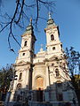 Serbian orthodox church Assumption of Holy Virgin, built 1807-1811
 -
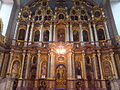 Iconostasis of Serbian orthodox church
 -
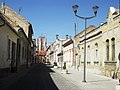 Street of old central quarter
 -
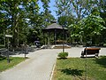 Urban park Narodna bašta in the center
 -
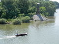 Tamiš lighthouse


Articles
References
- ^ "Gradonačelnik Pančeva". Grad Pančevo. 2020.
- ^ "Zamenik Gradonačelnika Pančeva". Grad Pančevo. 2020.
- ^ "ИЗВЕШТАЈ О ДОДЕЛИ ОДБОРНИЧКИХ МАНДАТА И ИЗДАВАЊУ УВЕРЕЊА ОДБОРНИЦИМА СКУПШТИНЕ ГРАДА ПАНЧЕВА" (PDF). Grad Pančevo. 26 June 2020.
- ^ "Насеља општине Панчево" (PDF). stat.gov.rs (in Serbian). Statistical Office of Serbia. Archived from the original (PDF) on 14 November 2015. Retrieved 24 October 2019.
- ISBN 978-86-6161-109-4. Retrieved 27 June 2014.
- ^ "Pančevo". 30 June 2019.
- ^ 2011 Census of Population, Households and Dwellings in the Republic of Serbia, Volume 2, Statistical Office of the Republic of Serbia, Belgrade 2012, p. 82.
- ^ Felix Milleker, Geschichte der Stadt Pantschowa, Pančevo 1925, p. 4-5.
- ^ "Climate: Pančevo, Serbia". Climate-Data.org. Retrieved 8 January 2018.
- ^ Turistička organizacija Pančevo. "Ptice Pančeva" (PDF). Pančevo: Ptice Pančeva – via Turistička organizacija Pančevo.
- ^ Felix Milleker, Geschichte der Stadt Pančevo, Pančevo 1925, p. 5-7.
- ^ Virtual visit at National Museum, National Museum Pančevo.
- ^ Hungaricana Maps, Map of City and Fortification from 1717.
- ^ Hungaricana Maps, Fortification Map from 1720.
- Luka Ilić, Historische Skizze der kaiserlich königlichen Militär-Communität Pantschowa, Pančevo 1855, Enclosing Map of 1814.
- ^ Pančevo on the Map of Franciscan Land Survey (1806–1869) at National Archives of Austria.
- ^ Hungaricana Maps, Cadastre maps Pancsova.
- ^ Srpske sinagoge kojih nema, History of the Synagogue on ARS Magine.
- ^ Als Zivilist im Balkankrieg, Vienna 1947.
- ^ Terezja Rihart, born November 7, 1909 in Jabuka, died July 21, 1993 in Vienna.
- ^ Ulrike Jureit and Hans Mommsen, Verbrechen der Wehrmacht, Hamburg 2002.
- ^ Jürgen Martschukat and Silvan Niedermeier, Violence and Visibility in Modern History, New York 2013.
- film scores of TV-documentaries with original materials: version 1 (36 Serbs) and version 2 (18 Serbs), YouTube. Retrieved 22 May 2017.
- ^ See also: Bor (Serbia) and Pančevački Rit
- ^ Theresia Richard, born November 7, 1909 in Jabuka, died July 21, 1993 in Vienna.
- ^ Akiko Shimizu, Die deutsche Okkupation des serbischen Banats 1941–1944 unter besonderer Berücksichtigung der deutschen Volksgruppe in Jugoslawien. Regensburger Schriften aus Philosophie, Politik, Gesellschaft und Geschichte. Band 5, Münster 2003.
- ^ Südostdeutsche Forschungsgemeinschaft, Die Gliederung der Bevölkerung des ehemaligen Jugoslawien nach Muttersprache und Konfession nach den unveröffentlichten Angaben der Zählung von 1931. Bearbeitet und herausgegeben von der Publikationsstelle Wien. Nur für den Dienstgebrauch, Vienna 1943.
- ^ Ortssippenbuch Pantschowa, structured in alphabetical order, edited by Elfriede and Michael Adelhardt.
- ^ City administrative area Archived 14 November 2015 at the Wayback Machine, Statistical Office of the Republic of Serbia.
- ^ Serbian Church Choral Society, YouTube.
- ^ Article on Davorin Jenko in: Stanoje Stanojević, Narodna enciklopedija srpsko-hrvatsko-slovenačka, Volume 2, Zagreb 1926, p. 153.
- ^ Official Website, the Kulturni Centar Pančeva.
- ^ Official Website, Dom omladine.
- ^ Official Website, PAFF.
- ^ Pančevo in film frames, 1956–2010 (PDF), Web archive of Pančevo City.
- ^ Official Website, Pančevački Karneval.
- ^ Official Website, Narodni Muzej.
- ^ Rezultati konkursa za idejno rešenje rekonstrukcje Vajfertove Pivare Super prostor, web portal for architecture and cultural space.
- ^ Georg Weifert Museum opened, article of Diplomacy&Commerce.
- ^ Official website, Vajfert Days.
- ^ Official Website, Istorijski arhiv u Pančevu
- National Library of Austria.
- Diocese of Zrenjanin.
- ^ History of Serbian Orthodox Church, Eparchia of Banat.
- ^ History of the iconostasis, Official Website, Church Assumption of Holy Virgin.
- ^ Cultural monuments, Turistička organizacija Pančevo.
- ^ Official Website, Institute for Protection of Cultural Monuments in Pančevo.
- ^ Official Website by Pančevac.
- ^ RTV and its YouTubeChannel.
- ^ Libertatea.
- ^ Official commercial address book of the City (PDF).
- ^ UNEP final report Pančevo (PDF).
- ^ Nature Park Ponjavica.
- ^ "MUNICIPALITIES AND REGIONS OF THE REPUBLIC OF SERBIA, 2019" (PDF). stat.gov.rs. Statistical Office of the Republic of Serbia. 25 December 2019. Retrieved 28 December 2019.
- ^ Autotransport Pančevo.
- ^ Felix Milleker, Die Banater Eisenbahnen 1847–1917, Vršac 1927, p.17.
- ^ Luka Dunav Archived 11 August 2018 at the Wayback Machine.
- ^ "Zbratimljeni gradovi". pancevo.rs (in Serbian). Pančevo. Retrieved 7 January 2020.
External links
- Official Website by the City of Pančevo
- Official Website by Turistička organizacija Pančeva
- ABC of Pančevo, city's first website started in 1997.
- 013info
- The local entertainment portal Pancevo Online and its YouTubeChannel
- Pančevo City
- Pančevo Moj Kraj
- News portal Južni Banat


| National | |
|---|---|
| Geographic | |