
Pan-American Highway
This article needs additional citations for verification. (February 2021) |
It has been suggested that Pan-American Highway (North America) and Pan-American Highway (South America) be merged into this article. (Discuss ) Proposed since September 2023. |

The Pan-American Highway[a] is a network of roads stretching across the Americas, measuring about 30,000 kilometres (19,000 mi)[1] in total length. Except for a break of approximately 100 km (60 mi) across the border between Colombia and Panama, the roads link most of the Pacific coastal countries of North America and South America in a connected highway system. According to Guinness World Records, the Pan-American Highway is the world's longest "motorable road".
The Pan-American Highway passes through many diverse climates and ecological types—ranging from dense jungles to arid deserts and barren tundra. Some areas are fully passable only during the dry season. There is no official authority for its composition, but it extends in de facto terms from Prudhoe Bay, Alaska in the north, to the southern cities of Puerto Montt and Quellón in Chile, and Ushuaia in Argentina.
Concept of the highway
The notion that there could and should be an inter-American highway, linking the nations of North, Central, and South America, is an idea originating from the United States.[2]
It was built in stages. The first, not long after one could drive across the United States on a paved road, was the highway from
The third stage, which has not been completed and may never be, continues onward to the southern tip of South America at
A Cuban proposal that was not carried out was to include a "circuito del Caribe" (Caribbean circuit). This would have expanded the highway to
Development and construction
The concept of an overland route from one tip of the Americas to the other was originally proposed as a railroad. In 1884 the U.S. Congress passed a law with a plan to build an inter-American rail system.[5] This was discussed at the First Pan-American Conference in 1889; however, construction never started. It was abandoned in concept after the independence of Panama in 1903, when work on the canal began.[5]
The concept of building a highway, rather than a railroad, emerged at the Fifth International Conference of American States in 1923, after the automobile and other vehicles had begun to replace railroads for both passenger and goods transportation. The first conference regarding construction of the highway occurred on October 5, 1925.
Finally, on July 29, 1937, in the latter years of the Great Depression, Argentina, Bolivia, Chile, Colombia, Costa Rica, El Salvador, Guatemala, Honduras, Mexico, Nicaragua, Panama, Peru, Canada, and the United States signed the Convention on the Pan-American Highway, whereby they agreed to achieve speedy construction, by all adequate means.[6] Thirteen years later, in 1950, Mexico became the first Latin American country to complete its portion of the highway.[7]
No single route in the United States (except in Alaska) has been designated, much less marked, as the U.S. portion of the Pan-American Highway. However, I-25 is labeled as the Pan-American freeway in states such as New Mexico and Colorado. According to the federal Department of Transportation, the Interstate Highway System is the United States' section of the highway. In Canada the highway is not marked. Much of the highway in Latin America is marked as Vía Panam or Vía Panamericana.
Countries served

The Northern Pan-American Highway travels through nine countries, including in Central America:
- Canada (CANAMEX Corridor unofficial)
- United States (Interstate Highway System official)
- Mexico
- Guatemala
- El Salvador
- Honduras
- Nicaragua
- Costa Rica
- Panama
The Southern Pan-American Highway travels through five countries:
Important spurs also connect with four other South American countries:
Northern section

Alaska
The
Canada
In Canada, no particular road has been officially designated as the Pan-American Highway. The National Highway System, which includes but is not limited to the Trans-Canada Highway, is the country's only official inter-provincial highway system. However, several Canadian highways are a natural extension of several key American highways that reach the Canada–US border. British Columbia Highway 97 and Highway 2 to Alberta both pick up where the southern end of the Alaska highway leaves off. Highway 97 becomes U.S. Route 97 at the Canada–US border. British Columbia Highway 99 provides an alternate route from Highway 97 just north of Cache Creek; it runs through Whistler and Vancouver before ending at the Canada–US border at the north end of Interstate 5 in Washington state, the beginning of the official Pan-American route south of British Columbia. Meanwhile, Alberta Highway 2 runs south and east to Alberta Highway 3 leading into Lethbridge, then south on Alberta Highway 4 to the Canada–US border, where it becomes Interstate 15 in Montana. This is the first official stretch of the Pan-American Highway south of the Alberta route, both of which are also part of the CANAMEX Corridor.
Yukon
Crossing the border into Canada, Alaska Highway 2 turns into Yukon Highway 1. The first significant settlement along the way is
Through most of Whitehorse,
At
British Columbia
After travelling about 8 km (5.0 mi) past the British Columbia–Yukon border, the Pan-American Highway reaches the first settlement in British Columbia at
The Pan-American Highway continues on B.C. Highway 97 as it passes through Toad River Post, and then Summit Lake, which is nested between Stone Mountain and Mount Saint George. Further down the road, B.C. Highway 97 intersects with B.C. Highway 77; the Pan-American Highway continues along B.C. 97 east to Fort Nelson.
From Fort Nelson, the Highway travels south for about 290 km (180 mi) until it reaches
Alberta
After B.C Highway 97, the unofficial route becomes Alberta Highway 43. In approximately 7.2 km (4.5 mi), Highway 43 enters into the first settlement Demmitt. For about 75 km (47 mi), Highway 43 goes into Grande Prairie. At Clairmont, Highway 43, turns to Alberta Highway 2, Highway 43 goes left. Highway 43 goes for 455 km (283 mi) before reaching Edmonton. The unofficial route turns 2 ways, one way goes to Lloydminster, Minneapolis, and Dallas and merges with the second way. The second way goes to Calgary and the US border.
Contiguous United States


In 1966, the U.S.
These include the following:
- Interstate 5 runs north from San Diego, California, to Blaine, Washington, then links indirectly with British Columbia Highway 99 north of the Canada–US border. A technically direct link between the same interstate and the U.S. Route 97 system can be found near Weed, California. US Route 97 runs northeast then north through Oregon and Washington from this junction, and becomes BC Highway 97 at the border with Canada.
- Nogalesborder crossing.
- Pan-American Freeway,[12]: 248 as an extension of Highway 45, the Mexican spur linking El Paso to the original route along highway 85 north of Mexico City.[13] This portion of I-25 largely follows the historic Camino Real, and thus serves a culturally significant portion of the Pan American system. Like I-15, the complete route of Interstate 25 is an official northerly continuation toward Alberta, where Highway 2 provides a direct but unofficial Canadian link to the Alaska Highway.
- Thunder Bay, Ontario. This route was first proposed in a 1932 bill[specify] introduced in the U.S. Congress. The Trans-Canada Highway provides a link from Winnipeg and Thunder Bay to Alberta and the Alaska Highway, but it is not officially part of the Pan-American Highway.
- U.S. Route 81 is claimed to be part of the Pan American Highway from Wichita, Kansas, to Watertown, South Dakota, where it runs separately from Interstate 29.
- An additional route only partially complete is Windsor-Quebec City Corridor in Canada, where the route becomes unofficial.
Related North American highways
Several North American routes have names that make no direct reference to the Pan-American Highway, in part because some sections follow highways that are not up to full freeway standard.
- The Las Vegas, Nevada to I-10 at Phoenix, Arizonafor traffic accessing I-15 from the Nogales border crossing.
- The CanAm Highway follows Interstate 25 from El Paso to U.S. Route 85 north of Denver, Colorado, then continues into the Canadian province of Saskatchewan, following parts of provincial highways 35, 39, 6, 3, and 2 in succession before terminating at La Ronge. This route was first proposed during the 1920s but was never properly promoted nor developed. A section of the CanAm in southern Saskatchewan has deteriorated to the point where it is no longer a paved highway.[15]
- The Windsor-Quebec City Corridor can be considered a northeastward extension of this version of the NAFTA superhighway. To the southwest, from western Kentucky to the Mexican border, there is no single superhighway yet completed. Pending completion of I-69, the main highway links to Mexico follow parts of US routes 45 and 51 from Kentucky to western Tennessee, I-155 into Missouri, parts of Interstates 55 and 40 from Missouri to Arkansas, and I-30 to the Texas stretch of I-35 that continues to the Mexican border at Laredo, Texas. The section of I-69 to be completed south of Kentucky is expected eventually to continue southwestward to the Texas Gulf Coast. It will have a spur linking to the original Pan-American route through Mexico to Laredo, and additional branches extending to the Mexican spurs that cross the border at Pharr, Texas, and Brownsville, Texas.
Mexico

The official route of the Pan-American Highway through Mexico (where it is known as the Inter-American Highway) starts at Nuevo Laredo, Tamaulipas (opposite Laredo, Texas), and goes south to Mexico City along Mexican Federal Highway 85.[16]
An alternative route begins at the border crossing between
The Pan-American Highway (as Mexico Highway 85D) enters Mexico City,
Later branches were built to the border as follows:
- Nogales spur – Mexican Federal Highway 15 from Mexico City
- El Paso spur – Mexican Federal Highway 45 from Highway 85 north of Mexico City to Ciudad Juárez, Chihuahua
- Eagle Pass spur – unknown, possibly Mexican Federal Highway 57 from Mexico City to Piedras Negras, Coahuila
- Pharr spur – Mexican Federal Highway 40 from Monterrey to Reynosa, Tamaulipas
- Brownsville spur – Mexican Federal Highway 101 from Ciudad Victoria to Matamoros, Tamaulipas
From Mexico City to the border with Guatemala, the highway follows Mexican Federal Highway 190.[18][19][20] In the inaugural Carrera Panamericana road race, organized by the Mexican government, the terminus of this southern route was said to be at Ciudad Cuauhtémoc, Chiapas, at the Guatemalan border.[21]
Specifically, as the Pan-American Highway continues south of Mexico City, it runs through the city of
From the city of Oaxaca, the Highway continues southeast as Mexico Highway 190 for about 230 km (140 mi) to the village of
Central America

_-_Route_Panam%C3%A9ricaine.JPG)
The Pan-American (or Inter-American) highway passes through the Central American countries with the highway designation of CA-1 (Central American Highway 1). Belize was supposedly included in the route at one time, after it switched to driving on the right. Prior to independence, as British Honduras, it was the only Central American country to drive on the left side of the road.[22]
Guatemala
Upon crossing into Guatemala, Mexico Highway 190 becomes Central America Highway 1 and continues for about 80 km (50 mi) from the border village of La Mesilla to the city of Huehuetenango near the Maya ruins of Zaculeu. The Pan-American Highway crosses the Continental Divide again, and into the Sierra de los Cuchumatanes mountains.
From Huehuetenango to
From Guatemala City to
In Guatemala, the Pan-American highway passes through 10 departments, including The Department Of Guatemala, where it passes through Guatemala City.
El Salvador
El Salvador is the smallest country (by area) along the route of the Pan-American Highway. After crossing into El Salvador at Candelaria de la Frontera, the Inter-American Highway continues on toward Santa Ana as Central America Highway 1. From the border crossing to Santa Ana is about 13 km (8.1 mi).
From Santa Ana it's about 45 km (28 mi)
From San Salvador to
In El Salvador, the highway also passes through the cities of,
Honduras
The highway crosses the border into Honduras at El Amatillo near Nacaome (40 km (25 mi) from border). Just past Nacaome is a highway traveling north to Tegucigalpa, the capital of Honduras. Traveling south, it is 40 km (25 mi) to Choluteca, the fourth-largest city in Honduras. From Choluteca to the border crossing, just past San Marcos de Colón, is about 68 km (42 mi). The Pan-American Highway's total distance in Honduras is about 148 km (92 mi).
Nicaragua
From Honduras, it passes into Nicaragua at
From the crossing at the
From San Benito, it is about 38 km (24 mi) to the Nicaraguan capital and largest city of
Costa Rica
In Costa Rica, the Pan-American Highway is known as Carretera Interamericana (Inter-American Highway) and is composed of two segments Carretera Interamericana Norte (Route 1) and Carretera Interamericana Sur (Route 2).
It passes through Liberia, San José, Cartago, Pérez Zeledón, Palmares, Neily, before crossing into Panama at Paso Canoas.
The highest point in the entire Pan-American Highway occurs at the Cerro de la Muerte (Death Hill) in the Carretera Interamericana Sur segment, at 3,335 m (10,942 ft).
An alternative route used by cross country buses and freight transportation that avoids crossing through the Greater Metropolitan Area and Cerro de la Muerte, is by taking Route 23 in Puntarenas canton from Route 1, then Route 27 and Route 34, and taking Route 2 in Osa canton.
After entering Costa Rica, the Highway separates two national parks, the
Liberia to the town of
After Alajuela the
San José is the capital and largest city in Costa Rica. Leaving San José, the Inter-American Highway winds its way roughly southeast. From San José to San Isidro de El General is about 136 km (85 mi)
From San Isidro, the
Panama
In Panama, it crosses the Panama Canal via the Centennial Bridge, and the pavement ends at Yaviza, at the edge of the Darién Gap: it is now being extended 6 km. to Pinogana, which will include a bridge over the Chucunaque River.[24] The road had formerly ended at Cañita, Panama, 180 km (110 mi) north of its current end. United States government funding was particularly significant to complete the high-level Bridge of the Americas over the Panama Canal, during the years when the canal was administered by the United States.
From the Costa Rica-Panama border to the village of La Concepción is about 20 km (12 mi), and from La Concepción to the city of David is about another 25 km (16 mi). The highway enters Panama traveling generally from west to east.
David, the capital of the
From Santiago to
From Penonomé, the highway travels southeast, then northeast, then roughly north in a loop as it avoids crossing into Panama's Central Mountains. From Penonomé to La Chorerra is about 100 km (62 mi). From La Chorerra, it is only about 25 km (16 mi) to Balboa just west of Panama City.
Panama City is the capital and largest city in Panama. Before entering the city, the Pan-American Highway crosses over the Panama Canal on the Centennial Bridge, From Panama City, the Highway turns northeast. From Panama City to Chepo is roughly 55 km (34 mi); from Chepo to Cañita is another 25 km (16 mi).
At the village of Cañita is the old terminus of the northern route of the Pan-American Highway. The highway continues another 180 km (110 mi) past Cañita to the village of Yaviza. This stretch of highway is extremely remote. Yaviza is a village near the junction of the Tuira and Chucunaque rivers. It is here that officially Pan- American Highway ends. From Yaviza southeast lies the virtually impenetrable Darién Gap, a 100 km (62 mi) stretch of rugged, mountainous jungle terrain.
Darién Gap

The Pan-American Highway is interrupted between Panama and Colombia by a 106 km (66 mi) stretch of marshland known as the Darién Gap. The highway terminates at Turbo, Colombia, and Yaviza, Panama. Because of swamps, marshes, and rivers, construction would be very expensive. One can cross through on foot, but it is both very difficult and very dangerous.
Efforts have been made for decades to eliminate the gap in the Pan-American highway, but have been controversial. Planning began in 1971 with the help of United States funding,
The Darién Gap has challenged adventurers for many years. A 1962 expedition with three Chevrolet Corvair rear-engine cars and two support trucks completed the trip south from Chicago through to the Colombian border.[26] A 1971–72 British expedition from Alaska to Argentina attempted to transit the Gap with two standard production Range Rovers, supported by a team of Land Rovers. They barely succeeded in thrashing a passage through the extreme terrain.[27] In 1979, a team led by Mark Smith drove standard production CJ7-model Jeeps from South to North, traversing the Gap with difficulty.[28] In 1984, Loren and Patty Upton made the first "all land" vehicle crossing of the Gap using a 1966 Jeep CJ-5 named Sand Ship Discovery. It took 741 days of slogging, winching, chopping, and digging their way through the inhospitable jungles of the Darién Gap.[29][30]
In the 21st century, many desperate Haitians and Venezuelans head north towards the Mexico–United States border, crossed the gap on foot, reporting terrible conditions.[31]
One proposed option to bridge the gap is a short ferry link from Colombia to a new ferry port in Panama,[32] with an extension of the existing Panama highway that would complete the highway without violating these environmental concerns. However, past attempts to operate such a service have ended in failure.
Southern section


Colombia and Venezuela
The southern part of the highway begins in Turbo, Colombia, from where it follows Colombia Highway 62 to Medellín. At Medellín, Colombia Highway 56 leads to Bogotá, but Colombia Highway 25 turns south for a more direct route. Colombia Highway 40 is routed southwest from Bogotá to join Highway 25 at Zarzal. Highway 25 continues all the way to the border with Ecuador.
Travelers along the
The main route of the Pan-American Highway in Colombia (starting from the northeast) begins just east of
From the department border, Route 66 continues southwest for 50 km toward
A 53-km stretch of highway connects Barbosa with Tunja, an important agriculture and mining center in the region. The Pan-American Highway switches routes again in Tunja, returning to Colombia Route 55 on its way to Cundinamarca and the national capital, Bogotá. The stretch of highway from Tunja to the departmental border with Cundinamarca is 54 km and is a toll road. From the Cundinamarca departmental line, the highway continues another 26 km without tolls before becoming a toll road again. From that point, the highway reaches Bogotá in 52 km.
In Bogotá, the highway crosses from the north to the southwest portion of the city, switching from Route 55 to Colombia Route 40. Continuing as a toll road from Bogotá, it travels for 128 km through Fusagasugá to the departmental border with Tolima.
From the Tolima departmental border, the highway continues as a toll road for another 16 km to
Upon crossing into Quindío,
From the border, the Pan-American Highway travels 26 km to the town of La Paila, where it crosses Colombia Route 25. At this junction, the two routes merge and become a toll road for 61 km from that point to Buga. At Buga, Route 40 splits west toward the city of Buenaventura and the Pacific Ocean; the Pan-American Highway continues south on Route 25 for another 42 km until arriving near Palmira. From Palmira, the highway continues southwest for 23 km, where it reaches the large city of Cali. From Cali to the Cauca departmental border is 19 km.
The highway continues south along Route 25 throughout its length in the department of Cauca. After 50 km, the highway becomes a toll road at Santander de Qulichao until reaching Santander de Qulichao and
From the Nariño departmental border, the highway continues south as Route 25. From the border to the city of
Simón Bolívar Highway
Another route, known as the Simón Bolívar Highway, runs from Bogotá (Colombia) to La Guaira (Venezuela). It begins by using Colombia Highways 55 & 66 all the way to the border with Venezuela. From there it uses Venezuela Highway 1 to Caracas and Venezuela Highway 9 to its end at La Guaira.
The road ends at Venezuela Highway 9 in Güiria, a small town in the state of Sucre just west of Trinidad along the Gulf of Paria coastline. From Güiria, the highway winds west 76 kilometres (47 mi) towards the town of Yaguaraparo.
Once the highway reaches Yaguaraparo, on the southern portion of the
Upon reaching Casanay, the highway crosses
After crossing into Anzoátegui, it almost immediately enters the city of Barcelona. Travelling from Barcelona and nearby
About 34 km west of Boca de Uchire, the highway starts climbing up the
At Caucagua, the Pan-American Highway crosses
Maracay is the capital city of Aragua state in central Venezuela. It was officially established on March 5, 1701, by Bishop Diego de Baños y Sotomayor in the valleys of Tocopio and Tapatapa (what is known today as the central valley of Aragua) in northern Venezuela. From Maracay the highway extends about 44 km to Valencia, passing San Joaquin and near Cuacara en route to the city.
From Guaremal to
From Barquisimeto, Highway 1 continues roughly west, then southwest (at around Agua Salada) for 147 km to the state line with Trujillo, near El Empedrado.
Once in the state of
The highway enters
Upon entering the state of
Peru, Ecuador and Chile

Ecuador Highway 35 runs the whole length of the country.Ecuador Highway 35, the "Troncal de la Sierra" (Highland's Road), is commonly known to Ecuadorians as "La Panamericana" and forms Ecuador's contribution to the project. It connects cities and towns from the Sierra region, from Tulcán at the north (border with Colombia), passing through Quito, the country's capital, to the southern border with Peru. Part of this highway is a toll-road administered by Panavial, a private concessionary. The road condition is quite good, but it mostly goes through mountains and it has some bad trails around the province of Cañar (center of the country), making it a fairly dangerous road to drive on.
The Ecuadorian portion begins at the Colombian border in Carchi province and almost immediately enters the city of Tulcán, the capital of Carchi province. From Tulcán, the road continues south for 125 km, reaching Ibarra. From Ibarra, the highway continues south for 115 km until reaching Quito. From Quito, the highway continues south for 89 km next reaching Latacunga.
From Latacunga, the Pan-American Highway continues south for 47 km to
From north of the city the Pan-American Highway takes the name of Avenida Circunvalación Sur (Avenue South Ring) until exiting to the south, where it shrinks to two lanes (one north, one south) enlarged in 2009 until reaching Loja.
From this point south the highway is called Carretera Panamericana Sur ("South Pan-American Highway"), until it reaches the southern border, located in the Santa Rosa Border Post (36 km south of
In
Argentina and Paraguay


In Argentina, the Argentina National Route 7 starts in the Christ the Redeemer tunnel, and continues to Buenos Aires, the end of the main highway.[34] The highway network also continues south of Buenos Aires along Argentina National Route 3 towards the city of Ushuaia in Tierra del Fuego. Another branch, from Buenos Aires to Asunción in Paraguay, heads out of Buenos Aires on Argentina National Route 9. It switches to Argentina National Route 11 at Rosario, which crosses the border with Paraguay right at Asunción. Other branches probably exist across the center of South America.
Brazil and Uruguay
A continuation of the Pan-American Highway to the
Guyana, Suriname and French Guiana
The highway does not have official segments to
West Indies section
Plans have been discussed for including the West Indies in the Pan American Highway system. According to these, a system of ferries would be established to connect terminal points of the highway. Travelers would then be able to ferry from Key West to Havana, drive to the eastern tip of Cuba, ferry to Haiti, drive through Haiti and the Dominican Republic, and ferry again to Puerto Rico. Included in this system would also be a ferry from the western tip of Cuba to the Yucatán Peninsula. Mexico has already surveyed a route which will run across the Yucatán, Campeche, and Chiapas to San Cristobal de Las Casas, on the Pan American Highway. ("The Pan American Highway System" by Travel Division Pan American Union, Washington D.C. October 1947)
Art and culture
Travel writer
In the British motoring show Top Gear, the presenters drove on a section of the road in their off-road vehicles in the Bolivian Special.
In 2003,
In 2018, British cyclist Dean Stott, who had planned on riding the length of the Americas in 110 days to set a new Guinness World Record, completed the 14,000-mile (22,500 km) journey in just under 100 days, riding south-to-north, breaking the record, set by Mexico's Carlos Santamaría Covarrubias in 2015, by 17 days.[37] Stott was inspired to push the timetable after learning that he and his wife had been invited to the wedding of Prince Harry and Meghan Markle, and would have missed the event had he stuck to his original schedule.[38] Stott's record lasted just a couple of months, as Austrian endurance cyclist Michael Strasser, riding north-to-south, broke the record with a time of 84 days, 11 hours and 50 minutes (July 23 – October 16, 2018).[39][40]
Photo gallery
-
 The northern end of the Pan-American Highway at Deadhorse, Alaska, USA
 -
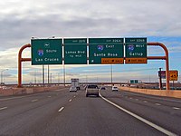 Interstate 25 (Pan-American Freeway) approaching the Big I interchange in Albuquerque, New Mexico, USA
 -
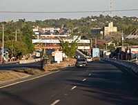 Pan-American Highway through San Martin, El Salvador.
 -
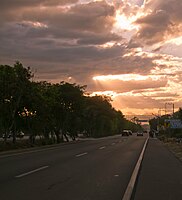 Another view of the Pan-American Highway in El Salvador.
 -
 Pan-American Highway in El Salvador between Lourdes and Santa Ana; this flat 1.5 km (0.93 mi) long straight section can be used as an airstrip and it was used duringEl Salvador Civil War.
 -
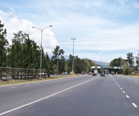
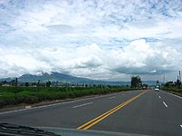
![Pan-American Highway in Guanacaste, Costa Rica (going towards the Nicaraguan border, still many kilometres [miles] away.)](//upload.wikimedia.org/wikipedia/commons/thumb/7/79/Carretera_Panamericana_en_Gunacaste_Costa_Rica.jpg/200px-Carretera_Panamericana_en_Gunacaste_Costa_Rica.jpg) Pan-American Highway in Guanacaste, Costa Rica (going towards the Nicaraguan border, still many kilometres [miles] away.)
Pan-American Highway in Guanacaste, Costa Rica (going towards the Nicaraguan border, still many kilometres [miles] away.) -
 Pan-American Highway in Tres Rios, Costa Rica, right before the toll plaza (about 337 more km / 209 more mi to go until the Panamanian border).
 -
 Pan-American Highway, at the border of Costa Rica and Panama
 -
 Panamericana – Pan American Highway – in Pichincha, Ecuador, near Cashapamba
 -
 Panamericana – Pan American Highway – northern Peru near Pacasmayo
 -
 Panamericana – Pan American Highway – near Puerto De Lomas, Peru
 -
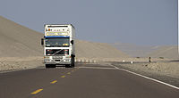
 Panamericana – Pan American Highway – in the Atacama Desert northern Chile
 -
 Chevy Suburban traveled all of the Pan-American Highway. Patagonia, Chile.
 -

-


![Pan-American Highway in Guanacaste, Costa Rica (going towards the Nicaraguan border, still many kilometres [miles] away.)](/File:Carretera_Panamericana_en_Gunacaste_Costa_Rica.jpg)


See also
- Transport in North America
- Transport in South America
- CANAMEX Corridor
- Continental 1
- NAFTA superhighway
- Other intercontinental highway systems:
- Trans-Siberian Highway
Notes
- ^ French: (Auto)route panaméricaine/transaméricaine; Portuguese: Rodovia/Autoestrada Pan-americana; Spanish: Autopista/Carretera/Ruta Panamericana
References
- ^ "A Gap in the Andes: Image of the Day". earthobservatory.nasa.gov. April 2, 2015. Retrieved January 22, 2017.
- ^ "Pan-American Highway | Description, History, Countries, Darien Gap, & Facts | Britannica". www.britannica.com. February 2, 2024. Retrieved February 15, 2024.
- Tico Times.
- OCLC 27001400.
- ^ ISBN 978-0-313-33661-4.
- ^ Text of the Convention.
- ^ "Highway Run". Harper's. July 2006. pp. 70–80.
- ^ "Yukon road map" (PDF). www.hpw.gov.yk.ca. Retrieved August 6, 2017.
- ^ "Road map of British Columbia". www.hellobc.com. Retrieved August 6, 2017.
- ^ American Automobile Association (c. 1974). American Motorist.
- New Mexico State Highway and Transportation Department (2007). State of New Mexico Memorial Designations and Dedications of Highways, Structures and Buildings (PDF). p. 14. Archived from the original(PDF) on July 16, 2011.
- OCLC 62109913. Retrieved February 13, 2013.
- Secretaría de Comunicaciones y Transportes. 2011. p. 5. Archived from the original(PDF) on May 14, 2012. Retrieved January 26, 2012.
- ^ "Federal Definition". Canamex coalition. Archived from the original on January 10, 2008.
- ^ "'Super corridor' theories simply updated old idea". The Star Phoenix. August 28, 2007. Archived from the original on March 1, 2015. Retrieved April 15, 2008.
- ISSN 0187-6961.
- ^ "Road Tips." (Pan-American Highway). Go-panamerican.com. Accessed June 2011.
- Secretaría de Comunicaciones y Transportes. 2011. pp. 2–3. Archived from the original(PDF) on May 14, 2012. Retrieved March 29, 2012.
- Secretaría de Relaciones Exteriores. pp. 1–2. Retrieved April 6, 2012.[permanent dead link]
- ^ "República de Guatemala – Red Vial con Distancias" (PDF) (in Spanish). Instituto Geografico National (IGN); Ministerio de Comunicaciones Infraestructura y Vivienda (CIV). 2009. Archived from the original (PDF) on May 11, 2013. Retrieved April 9, 2012.
- S2CID 145120707.
From Tuxtla, drivers made the final dash to the finish line in the small village of El Ocotal, struggling over the last 107 miles of still unpaved highway.
- JSTOR 1779904.
- ^ "Archived copy". Archived from the original on June 27, 2010. Retrieved June 26, 2010.
{{cite web}}: CS1 maint: archived copy as title (link) - ^ "Construcción de la nueva carretera de Yaviza a Pinogana alcanza un 16% de avance".
- ^ U. S. Government Accountability Office. "Linking the Americas: Progress and Problems of the Darien Gap Highway | U.S. GAO". www.gao.gov. Retrieved February 15, 2024.
- ^ Lenny Clairmont (February 21, 2016). "Daring The Darien". Archived from the original on December 12, 2021 – via YouTube.
- ^ "Range Rover Darien Gap - Range Rover Classic".
- ^ MotorTrend Channel (May 12, 2015). "The Greatest Jeep Adventure Ever! Mark Smith & The Darien Gap - Dirt Every Day Ep. 39" – via YouTube.
- ^ "Romantic High Adventure Expeditions". www.outbackofbeyond.com.
- ^ "Roadless Jungle, Irate Kunas and Guerrilla Encounters - Darien Gap Expedition". Motorcycle Podcasts Adventure Rider Radio & RAW.
- ^ "UN calls for regional solutions to curb record migration through Darien Gap". Reuters. August 2, 2023. Retrieved August 9, 2023.
- ^ "The Coming Era of Mega Systems, Part 1 – Transportation". DaVinci Institute – Futurist Speaker. December 16, 2014. Retrieved February 10, 2017.
- ^ Source: Atlas Caminero de Chile
- ^ "Pan-American Highway – MSN Encarta". Archived from the original on May 13, 2008. Retrieved September 19, 2008.
- ISBN 978-0-394-75837-4.
- ^ Walker, Tim (September 29, 2005). "How to have a real adventure: Take a train or get on a bike to experience the thrill of travel as it used to be". The Independent. London. Archived from the original on May 24, 2022. Retrieved August 3, 2010.
- ^ "Special Forces soldier breaks record for cycling the Pan-American Highway". Guinness World Records. June 5, 2018. Retrieved November 19, 2020.
- ^ "British cyclist smashes Pan American Highway record after learning of royal wedding invitation". road.cc. May 14, 2018. Retrieved October 2, 2018.
- ^ "Fastest cycle journey of the Pan-American Highway". Guinness World Records. Retrieved November 19, 2020.
- ^ Eberle-Abasolo, Christian (February 25, 2019). "The Austrian endurance rider set a new world record in 2018 when he cycled 22,642km from Alaska to Patagonia in 84 days. Here are all the need-to-know facts, figures and quotes from his big journey". www.redbull.com. Retrieved November 19, 2020.
General sources
- "Plan Federal Highway System". The New York Times. May 15, 1932. Section XX p. 7.
- "Reported from the Motor World". The New York Times. January 26, 1936. Section XX, p. 6.
- "Hemisphere Road Is Nearer Reality". The New York Times. January 7, 1953. p. 58.
- 1997–98 AAA Caribbean, Central America and South America map
- "Longest Road in the World". Popular Mechanics. March 1943.
- Rand McNally Road Atlas, 1998 edition, p. 120, ISBN 0-528-83918-7
- Institute for Central American Studies – Costa Rica map
- Maps for DXers by Don Moore
Further reading
- Rutkow, Eric (2019). The Longest Line on the Map: The United States, the Pan-American Highway, and the Quest to Link the Americas. Scribner. ISBN 9781501103926.
External links
 Geographic data related to Pan-American Highway at OpenStreetMap
| International | |
|---|---|
| National | |
| Other | |