
Parinacota (volcano)
| Parinacota Parina Quta | |
|---|---|
Ultra | |
| Coordinates | 18°09′58″S 69°08′31″W / 18.166°S 69.142°W[2] |
| Geography | |
 Parinacota Parina Quta Location in Bolivia, on the border with Chile | |
| Location | Central Volcanic Zone |
| Last eruption | 290 CE ± 300 years |
| Climbing | |
| First ascent | 1928 |
| Easiest route | snow/rock scramble |
Parinacota (in Hispanicized spelling), Parina Quta or Parinaquta is a
The volcano started growing during the Pleistocene and formed a large cone. At some point between the Pleistocene and the Holocene, the western flank of the volcano collapsed, generating a giant landslide that spread west and formed a large, hummocky landslide deposit. The avalanche crossed and dammed a previously existing drainage, impounding or enlarging Lake Chungará; numerous other lakes now forming the headwaters of the Rio Lauca sprang up within the deposit. Volcanic activity rebuilt the cone after the collapse, cancelling out the collapse scar.
Parinacota had numerous effusive and explosive eruptions during the Holocene, the latest about 200 years ago. While there are no recorded eruptions, legends of the local Aymara people imply that they may have witnessed one eruption. Renewed activity at Parinacota is possible in the future, although the relatively low population density in the region would limit potential damage. Some towns and a regional highway between Bolivia and Chile are potentially exposed to the effects of a new eruption.
Name
The name "Parinacota" is
Geomorphology and geology
Parinacota lies on the western margin of the Altiplano in the Central Andes. The border between Bolivia and Chile bisects the volcano and runs along the rim of the crater, which lies in Bolivia.[6] In Chile, where most of the edifice is located,[7] Parinacota lies in the commune of Putre, Arica y Parinacota Region, and in Bolivia in the Oruro Department of the Sajama Province.[8] The towns of Ajata and Parinacota lie southwest and west of the volcano, respectively.[9] The region lies at high altitude and access is difficult, hampering research on the volcanoes of the Central Andes.[10]
Regional

The
Parinacota is part of the CVZ, which contains about 44 active volcanoes.
Subduction-related volcanism in the region has been ongoing since 200 million years ago, burying most of the
Local
Parinacota is a highly symmetric volcanic cone,
The volcano is capped by a 1 kilometre (0.62 mi) wide
The cone sits atop a 50 metres (160 ft) thick multilobed
-
 Parinacota volcano
 -
 The white lava domes and a black lava flow are visible above the lake
 -
 The domes at the foot of Parinacota are well visible. In the middle right of the image, one of the Ajata lava flows is recognizable
 -
 The grey lava domes and a black Ajata lava flow are clearly visible
 -
 A black lava flow almost reaches the lake


South of the main edifice lie the
Older are the large
On the northern side Parinacota partly overlaps with Pomerape.
Glaciers
The old cone was subject to

Presently, a 4 square kilometres (1.5 sq mi)[22] or 12 square kilometres (4.6 sq mi) large ice cap covers the upper parts of the volcano[6] and drops down to an elevation of about 5,600 metres (18,400 ft).[37] There is also a large glacier on its southern flank.[24] Some reports disagree with calling any part of Parinacota's ice cap a "glacier", however.[38] Between 1987 and 2016, ice area at Parinacota and Pomerape declined by 1.94% every year.[39] A retreat of 0.9 square kilometres (0.35 sq mi) was noted between 2002 and 2003,[40] and as of 2007[update] most of the ice lies on the western slope of the mountain.[7]
Sector collapse

Parinacota shows evidence of a major sector collapse (a giant landslide),[1] whose deposit was originally interpreted to be a lava flow.[41][42] The collapse removed a volume of about 5–6 cubic kilometres (1.2–1.4 cu mi) from the cone, plunged over 1,900 metres (6,200 ft) vertical distance[43] and flowed 23 kilometres (14 mi) west, covering a surface area of 110 square kilometres (42 sq mi)[44] or 253 square kilometres (98 sq mi) with debris; the volume is not very well established.[43] [45]
As the volcano grew, it put more and more load on relatively weak sedimentary material that the volcano had developed on, deforming it, until these sedimentary rocks gave way.[46][47] The western slope might have been weakened by glacial action, further facilitating the onset of the collapse.[48] The collapse was probably sequential from the lower part of the edifice to the summit,[49] and it formed an avalanche of rocks that flowed down the volcano.[50] This flow was probably laminar and extremely fast (25–60 metres per second (82–197 ft/s)[22] ), judging from the morphologies of the avalanche deposit,[23] and it incorporated substantial pre-collapse sediments from the Lauca basin.[51] As the avalanche descended the slopes of the volcano, it picked up enough speed to run up on some topographical obstacles.[45] Such collapses have occurred on other volcanoes in the CVZ such as Llullaillaco, Ollagüe, Socompa and Tata Sabaya; the most recent event occurred between 1787 and 1802 at Tutupaca in Peru and was much smaller than the Parinacota sector collapse.[52]
The collapse event resembled the one that occurred on Mount St. Helens during the latter's eruption in 1980,[33] although the Parinacota collapse was three times larger.[53] A separate, minor sector collapse occurred on a lava dome on the southwestern foot of the volcano at an unknown time.[7] Such sector collapses are a common phenomenon on volcanoes.[54]

The avalanche eventually came to rest in a large "L" with the long side extending along the axis of the collapse and the short side closer to the edifice pointing north[55] where its advance was limited by tomography,[56] formed an exceptionally well preserved debris avalanche deposit.[54] This deposit has a "hummocky" appearance typical for sector collapse deposits; individual hummocks can reach sizes of 400–500 metres (1,300–1,600 ft) and heights of 80 metres (260 ft),[42] with the size decreasing away from the volcano.[57] The formation of these hummocks was probably influenced by the pre-existing structure of the edifice; much of the original stratigraphy of the pre-collapse edifice was preserved within the final collapse deposit.[46] As the avalanche came to rest, compressional ridges formed with axes perpendicular to the movement of the avalanche.[58] A few large Toreva blocks lie in the avalanche deposit just at the foot of Parinacota,[7] they reach heights of 250 metres (820 ft) and volumes of 0.05 cubic kilometres (0.012 cu mi).[31] Large blocks with sizes of up to 100 metres (330 ft) are part of the deposit, and some of these blocks preserve details of the pre-collapse structure;[44] the blocks reach sizes of 0.5–2 metres (1 ft 8 in – 6 ft 7 in) even at large distances from Parinacota.[23] These large blocks dominate the avalanche deposit; fine material is not present in the Parinacota collapse deposit,[59] an unusual feature among debris avalanches.[46] Some blocks slid away from the main avalanche deposit.[60] The avalanche deposit displays a noticeable split into two units; the upper one is andesitic and originated from the actual cone, the lower one is derived from the lava domes beneath the present-day edifice.[22]
This collapse gave birth to Lake Chungará when the avalanche flowed across a westbound drainage between

Within the hummock-like topography of the deposit, a number of other lakes and
A pumice fall deposit of
Surroundings
The terrain around Parinacota is mostly formed by
A number of volcanoes have been active around Parinacota in the last one million years.
Periglacial and erosional landforms
Erosion has formed gullies on the upper sector of Parinacota.
Petrology
Volcanic rocks erupted by Parinacota range in composition from
Overall, volcanic rocks at Parinacota belong to a
The magmas that formed Parinacota and Pomerape are considered to be a group distinct from these that formed older volcanic centres in the region, but also distinct from the magmas that formed the subsidiary vent of Pomerape and the Ajata cones; these tend to be more mafic.[80] In turn, the younger and older Ajata cone lavas have different compositions,[85] one having a high quantity of strontium and the other a low one.[82]
Magmas in the Parinacota region formed through distinct processes. One of these is fractional crystallization within closed magma chambers.[86] Another is the mixing of different magmas, one of which in the case of Parinacota may be the Ajata magmas.[81] More specifically, two different magmas with compositions akin to the Ajata magmas contributed the mafic element to the Parinacota magmas.[87] Some differences in magma composition between various volcanoes and stages may reflect the occurrence of several different magma differentiation events.[88]
Processes within magma chambers play an important role in the formation of the magmas erupted by volcanoes.
In the case of Parinacota, there is a noticeable difference between the pre-sector collapse and post-sector collapse magmas, indicating that a large turnover of the magmatic system was triggered by the landslide.[94] More specifically, after the collapse erupted rocks became more mafic[21] and their composition more influenced by fractional crystallization, while the preceding magmas were more strongly affected by mixing processes.[95] Also, magma output increased significantly,[82] while the resting time in the magma chambers decreased.[96] Modelling indicates that over the short term, a collapse would cause activity to stop at a volcano of Parinacota's size, and over the long term the plumbing system would change and become shallower.[97][90] Also, the plumbing system of the volcano would become more permissive to denser mafic magmas after a sector collapse, perhaps explaining why the Ajata vents were active after the collapse but the magma erupted through them influenced petrogenesis of main cone magmas much earlier.[30] The magnitude of such changes is considerably larger than at neighbouring volcano Taapaca, where a sector collapse was not accompanied by changes in activity; presumably Parinacota's shallower magma supply system made it more susceptible to the effects of unloading.[98]
The source of the Parinacota magmas is ultimately the mantle wedge above the slab of the Nazca Plate. Fluids released from the slab flux the wedge and trigger the formation of melts, with the assistance of asthenospheric material that is hotter and gets transported into the wedge.[99] These ascending magmas then interact with the crust, resulting in extensive changes to their composition.[100] The area in the crust where such interaction takes place is known as "MASH" or "Melting Assimilation Storage Homogenization", and it is there that the base magmas are formed which then enter into shallow magmatic systems.[101] Further, the relative thickness of the crust and narrowness of the mantle wedge mean that garnet is stable within the wedge, causing the magmas to be influenced by garnet-linked petrogenic processes. Shallower crustal components such as the locally extensive Lauca-Perez ignimbrite may have been assimilated by Parinacota as well.[77] These crustal components contributed about 12% of the primitive magmas as erupted by the Ajata cones, while the mantle wedge contributed 83%. Fluids from the slab and sediments subducted in the Peru-Chile Trench added the remaining 3 and 2%.[102]
Climate
Average temperatures at Parinacota are about 2.5–6 °C (36.5–42.8 °F),[103] with the 0 °C (32 °F) isotherm hovering between 4,800–4,900 metres (15,700–16,100 ft) elevation.[104] On neighbouring Sajama, on the summit temperatures range −7.5 – −14 °C (18.5–6.8 °F).[6] The atmosphere becomes thinner and drier at higher altitudes, allowing both increased solar radiation to reach the surface during daytime and more thermal radiation from the ground to escape to the top of the atmosphere during night. This pattern determines a large diurnal temperature amplitude in the region, with variations on the scale of 20–16 °C (36–29 °F).[105]
.jpg)
Average precipitation at Parinacota is about 440 millimetres per year (17 in/year).[22] Between about 12 and 26° degrees southern latitude, most of the moisture that arrives was absorbed by winds over the Amazon and transported to the Andes. Thus, humidity increases from west to east,[105] with the Pacific coastline being particularly dry.[106] Parinacota lies within the puna seca climate region,[107] where precipitation occurs over 7 or 8 months of wet season and results in a total amount of 500–250 millimetres per year (19.7–9.8 in/year),[105] most of it falling during the summer months when the Altiplano warms up under the sun, generating a monsoon-like wind current.[108] The summer precipitation is also known as the "Bolivian winter" or "Altiplanic winter".[106] This is an unusual precipitation pattern for Chile; most of the country has a mediterranean climate where most precipitation occurs during the winter months.[109]

The arid climate is a consequence of the activity of the
Winds at Parinacota come generally from the west, except during the wet season when easterly winds are common.
Flora and fauna

The Andes are a long mountain chain with different climates at various latitudes and elevations. Thus, vegetation differs from one location to the other.
| Vegetation zone | Species |
|---|---|
| Wet sandy soils | Ephedra breana, Festuca, Pennisetum, Werneria glaberrima |
| Brackish and wet soils | Festuca orthophylla, Festuca scirpifolia, Poa |
| Wetlands and impermeable soils | Carex, Festuca scirphifolia, Oxychloe andina |
| Some species in the grass vegetation area[114] | |
-

-
 Vegetation at Lake Chungará; the summit of Parinacota is enveloped in a cloud


Among the ecological factors that determine vegetation in the region are lack of water, saline soils, plentiful
-
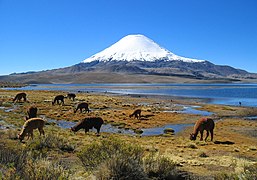
 Animals in front of Lake Chungará
 -
 Animals in front of Lake Chungará


Animal species that live around Parinacota include
Many mammal species in the area were decimated in the past, although some have displayed a recent recovery in numbers.[117] Parinacota and surroundings in 1965 were made part of the Lauca National Park, which was further modified in 1970 and 1983. This natural preserve features a unique flora and fauna for Chile.[109] However, potential future water diversions from Lake Chungará, the hunting of indigenous animals, overharvesting of the vegetation, overgrazing and the existence of a major border-crossing highway close to Lake Chungará constitute ongoing threats to the environment around Parinacota.[119]
Lake Chungará adds to the local flora and fauna. These include
Eruptive history
Parinacota underwent five separate stages of volcanic activity.
Chungará Andesites and lava domes

The oldest volcanic structure of Parinacota are the "Chungará Andesites" and the overlying lava dome, which form the platform that crops out on the southern side of the Parinacota volcano, facing Lake Chungará.[26] Erosion and glacial action has smoothed the surfaces of these rocks, leaving no primary textures.[22]
This platform was erupted between 300,000 and 100,000 years ago.[1] The finer subdivision defines the "Chungará Andesites" as having erupted 163,000–117,000 years ago and the "Rhyolite domes" being 52,000–42,000 years old.[21] Other dates obtained on these stages are 110,000 ± 4,000 and 264,000 ± 30,000 years ago for the Chungará Andesites and over 112,000 ± 5,000 for the "rhyolite domes".[33] These two units are also called "Parinacota 1".[22] A hiatus of over 60,000 years occurred between the eruption of the "Chungará Andesites" and the formation of the lava dome plateau. Traces of explosive activity during the lava dome stage have been found.[27]
The "Chungará Andesites" have a volume of over 4 cubic kilometres (0.96 cu mi);[26] material from these stages was incorporated in the collapse deposit.[23] Pomerape volcano developed during this time as well.[27] This and the long delay between the eruption of the Chungará Andesites and the rest of the volcano's history may imply that the magmatic systems involved were different.[30] Magma output during the early stage was low, with a magma output of 0.13 cubic kilometres per year (0.031 cu mi/a) with the dome growth contributing 0.5 ± 0.18 cubic kilometres per year (0.120 ± 0.043 cu mi/a).[124]
Old Cone and sector collapse
At the same time as the lava domes were emplaced, the Old Cone started growing a short distance northwest of the domes.[31] The temporal gap between this stage of Parinacota's activity and the previous one may be because the deposits from this time interval are only poorly preserved.[125] The Old Cone developed over 85,000 years until the sector collapse,[1] and is also known as Parinacota 2.[22] Outcrops of this stage are found mostly low on the southeastern and north-northwestern slopes;[7] individual dates obtained on rocks from this stage are 20,000 ± 4,000, 46,700 ± 1,600,[21] and 53,000 ± 11,000 years ago.[33] The "Border Dacites" also belong to this stage, being dated at 28,000 ± 1,000 years ago.[31] Likewise, ash fall deposits found in the Cotacotani lakes have been dated to this period of volcanic history, indicating that the Old Cone occasionally featured explosive eruptions.[22] This stage erupted andesite and dacite[1] in the form of three distinct suites.[21] Magma output during this time was about 0.46 ± 0.11 cubic kilometres per year (0.110 ± 0.026 cu mi/a).[124] This also was a time of glacier growth and development in the region, and consequently a glacier cap developed on the Old Cone during this time. By the time of the sector collapse, the glaciers were already retreating.[31]
The date of the collapse is not known with certainty, because dates have been obtained on various materials with different stratigraphic interpretations.[25] As of 2007[update] 18,000 years ago was considered the most likely estimate, but ages as young as 8,000 years ago were also proposed.[21] Radiocarbon dates from peat within the collapse deposit indicated an age of 13,500 years ago,[42] or 11,500–13,500 years ago.[28] Many dates were obtained on material predating the collapse that was embedded within the collapse deposit, and thus the most likely time for the collapse was considered to be 8,000 years ago.[126] Later research indicated an age between 13,000 and 20,000 years ago,[30] the most recent proposal is 8,800 ± 500 years before present.[127]
The postulated period coincides with a global clustering of volcano collapse events; perhaps global warming occurring during this time when the last glacial maximum approached its end predisposed volcanoes to collapse.[31][128] On the other hand, the younger dates of around 8,000 years ago significantly post-date the end of glaciation, thus if the collapse occurred at that time it was probably unrelated to glacial fluctuations.[129] This collapse and the collapse of Socompa farther south may have affected humans in the region.[65]
Young cone and Ajata

After the collapse, the cone was relatively rapidly rebuilt during the Young Cone stage[1] reaching a total volume of approximately 15 cubic kilometres (3.6 cu mi).[26] The units erupted during this time are also known as the "healing flows"[23] or Parinacota 3.[22] During this stage, volcanic activity was focused on the summit crater.[30] This stage was relatively short and accompanied by an increase in the magma output of Parinacota[23] to 2–0.75 cubic kilometres per year (0.48–0.18 cu mi/a) depending on how the duration of this stage is measured.[124] The higher magma flux is comparable to peak output by other large stratovolcanoes.[53] The maximum possible magma flux at Parinacota during this period is about 10 cubic kilometres per year (2.4 cu mi/a).[129]
Apart from lava flows, sub-Plinian eruptions generated pumice and scoria flows,[23] with some individual explosive eruptions dated to 4,800 ± 800, 4,300 ± 2,600 and 3,600 ± 1,100 years ago.[30] Based on the patterns of tephra deposition in Lake Chungará, it is inferred that the rate of explosive activity increased after the early Holocene until recent times;[130][131] in addition, tephra falls contributed calcium to the lake waters[132] and impacted its biological productivity.[133] It has been proposed that dust particles found in ice cores at Nevado Sajama may actually be tephra from Parinacota.[134]
Various Holocene dates have been obtained from rocks on the southern flank of the Young Cone;
Other recent activity, originally considered to be the youngest, formed the Ajata cones.[22] These cones are constructed by basaltic andesite[1] with a volume of about 0.2 cubic kilometres (0.048 cu mi).[26] The Ajata cones form four groups of different ages:[7] The lower Ajata flows were erupted 5,985 ± 640 and 6,560 ± 1,220 years ago,[135] the upper Ajata flows 4,800 ± 4,000 years ago, the middle Ajata flows 9,900 ± 2,100 years ago,[7] and the High Ajata flows 2,000 – 1,300 years ago. These groups also form compositionally distinct units.[136] The youngest surface exposure date obtained is 1,385 ± 350 years ago.[135]
According to SERNAGEOMIN,
Present-day activity and hazards
Presently, Parinacota is
The volcano is one among ten volcanoes in northern Chile monitored by SERNAGEOMIN and has a volcano hazard level published.[140] The relatively low population density on the Bolivian side of the volcano means that renewed activity would not constitute a major threat there,[141] although the town of Sajama may be affected.[22] The Arica-La Paz highway runs close to the volcano and might be threatened by mud and debris flows, along with small communities in the area.[141] Communities close to the volcano include Caquena, Chucullo and Parinacota. Potential hazards from future activity include the development of lahars from interactions between magma and the ice cap,[8] as well as eruptions from the flank vents; ash fall from prolonged flank vent eruptions could disturb pastures in the region. The important natural preserve that is the Lauca National Park could suffer significant disruption from renewed eruptions of Parinacota.[22]
Legends and archeology
The region around Parinacota has been inhabited for about 7,000–10,000 years. Politically, since 1,000 years ago first
Several legends concern Parinacota and its sister mountain Pomerape, which are often portrayed as unmarried sisters. Some involve a dispute with or between the mountains Tacora and Sajama, often resulting in Tacora being driven off.[143]
Gallery
- Parinacota and Pomerape, the Nevados de Payachata
-
 Parinacota on the right and Pomerape on the left
 -
 Parinacota and Pomerape
 -
 Parinacota on the right and Pomerape just right of the centre
 -
 Parinacota, on the left Pomerape
 -
 Parinacota, on the left Pomerape


.jpg)


See also
References
- ^ a b c d e f g h i j k l m n o Davidson et al. 1990, p. 413.
- ^ a b "Parinacota". Global Volcanism Program. Smithsonian Institution.
- ^ Ludovico Bertonio, Aymara-Spanish dictionary (transcription): Parina – Pájaro grande colorado, que se cría en la laguna; Teodoro Marka M., NOCIONES BASICAS DE LENGUA AYMARA Nociones Basicas de Lengua Aymara: Parina, pariwana = flamenco rosado (p. 21)
- ^ www.katari.org Aymara-Spanish dictionary: Quta (s.) – Lago.
- ISBN 978-94-009-2141-2.
- ^ a b c d Reese, Liu & Mountain 2003, p. 469.
- ^ a b c d e f g h i j k Hora, Singer & Wörner 2007, p. 348.
- ^ SERNAGEOMIN. Archived from the originalon February 10, 2018. Retrieved 2017-05-03.
- ^ Herrera et al. 2010, p. 301.
- ^ a b c d Wörner et al. 1988, p. 288.
- ^ .
- ^ a b Davidson et al. 1990, p. 412.
- ^ Wörner et al. 1988, p. 287,288.
- ^ a b c Wörner et al. 1988, p. 289.
- ^ a b Karátson, Telbisz & Wörner 2012, p. 122.
- ^ Avila-Salinas 1991, p. 247.
- ^ Avila-Salinas 1991, p. 248.
- ^ Avila-Salinas 1991, p. 249.
- ^ Karátson, Telbisz & Wörner 2012, p. 126.
- .
- ^ a b c d e f g h Ginibre & Wörner 2007, p. 121.
- ^ .
- ^ a b c d e f g h i j k l m Wörner et al. 1988, p. 296.
- ^ a b c d Rundel & Palma 2000, p. 264.
- ^ a b Sáez et al. 2007, p. 1194.
- ^ a b c d e f Hora, Singer & Wörner 2007, p. 346.
- ^ a b c Hora, Singer & Wörner 2007, p. 354.
- ^ a b c d e Hernández et al. 2008, p. 352.
- ^ Herrera et al. 2010, p. 303.
- ^ a b c d e f g Hora, Singer & Wörner 2007, p. 357.
- ^ a b c d e f g h Hora, Singer & Wörner 2007, p. 356.
- ^ Karátson, Telbisz & Wörner 2012, p. 124.
- ^ a b c d e f g Wörner et al. 1988, p. 294.
- ^ a b Rundel & Palma 2000, p. 263.
- S2CID 128552894.
- ^ S2CID 187666121.
- ^ a b Schröder 2001, p. 132.
- .
- ISSN 0022-1430.
- ISSN 0260-3055.
- ^ Wörner et al. 1988, p. 290.
- ^ a b c d e f g h i Francis & Wells 1988, p. 263.
- ^ a b Francis & Wells 1988, p. 260.
- ^ a b Wörner et al. 1988, p. 295.
- ^ a b Clavero et al. 2002, p. 44.
- ^ a b c d Clavero et al. 2002, p. 52.
- ^ Roverato, Dufresne & Procter 2021, p. 99.
- ^ a b Jicha et al. 2015, p. 1683.
- ^ Clavero et al. 2002, p. 50.
- ^ Clavero et al. 2002, p. 51.
- ^ Clavero et al. 2002, p. 43.
- S2CID 127649737.
- ^ Bibcode:2005AGUFM.V44B..05H.
- ^ a b Jicha et al. 2015, p. 1681.
- ^ Jicha et al. 2015, p. 1682.
- ^ Roverato, Dufresne & Procter 2021, p. 159.
- ^ Clavero et al. 2002, p. 46.
- ^ Roverato, Dufresne & Procter 2021, p. 146.
- ^ Capra 2007, p. 52.
- ^ Roverato, Dufresne & Procter 2021, p. 55.
- ^ Capra 2007, p. 47.
- ^ Sáez et al. 2007, p. 1199,1200.
- ^ Jicha et al. 2015, p. 1686.
- ^ Wörner et al. 1988, p. 294,295.
- ^ JSTOR 25674602.
- ^ Clavero et al. 2002, p. 42,44.
- ^ Herrera et al. 2010, p. 308.
- ^ Capra 2007, p. 54,55.
- ^ a b Sáez et al. 2007, p. 1195.
- ^ Hernández et al. 2008, p. 361.
- ^ Hora et al. 2009, p. 77.
- ^ Francis & Wells 1988, p. 264.
- ^ Clavero et al. 2002, p. 40.
- ^ a b Ginibre & Wörner 2007, p. 119.
- ^ a b Hora, Singer & Wörner 2007, p. 345.
- ^ Wörner et al. 1988, p. 292.
- ^ a b Hora et al. 2009, p. 76.
- ^ Quintanilla 1983, p. 32.
- ^ Schröder 2001, p. 119.
- ^ a b Davidson et al. 1990, p. 414.
- ^ a b c Ginibre & Wörner 2007, p. 120.
- ^ a b c Ginibre, Wörner & Kronz 2002, p. 301.
- ^ Wörner et al. 1988, p. 300.
- ^ Hora et al. 2009, p. 84.
- ^ Davidson et al. 1990, p. 418.
- ^ Davidson et al. 1990, p. 421.
- ^ Ginibre & Wörner 2007, p. 137.
- ^ Davidson et al. 1990, p. 422.
- ^ Ginibre, Wörner & Kronz 2002, p. 300.
- ^ a b Ginibre & Wörner 2007, p. 138.
- ^ Hora et al. 2009, p. 83,84.
- ^ Hora et al. 2009, p. 82.
- ^ Bourdon, Wörner & Zindler 2000, p. 461.
- ^ Davidson et al. 1990, p. 424.
- ^ Ginibre & Wörner 2007, p. 122.
- ^ Bourdon, Wörner & Zindler 2000, p. 467.
- ^ Roverato, Dufresne & Procter 2021, p. 329.
- ^ Wörner, G.; Hora, J.; Ginibre, C. (2008). "Changing regimes in sub-volcanic magma systems in the Central Andean Volcanic Zone due to sector collapse" (PDF). EGU General Assembly 2008. Retrieved 1 May 2017.
- ^ Davidson et al. 1990, p. 426.
- ^ Davidson et al. 1990, pp. 427–428.
- ^ Ginibre & Wörner 2007, p. 118.
- ^ Bourdon, Wörner & Zindler 2000, p. 464.
- ^ a b Quintanilla 1983, p. 36.
- ^ Schröder 2001, p. 129.
- ^ a b c d Quintanilla 1983, p. 30.
- ^ a b c Herrera et al. 2010, p. 300.
- ^ Quintanilla 1983, p. 31.
- ^ Schröder 2001, p. 121.
- ^ a b c Rundel & Palma 2000, p. 262.
- ^ Karátson, Telbisz & Wörner 2012, p. 125.
- ^ a b c d Rundel & Palma 2000, p. 265.
- ^ Schröder 2001, p. 120,121.
- ^ Guédron et al. 2019, p. 905.
- ^ a b c d e Quintanilla 1983, p. 34.
- ^ a b Reese, Liu & Mountain 2003, p. 470.
- ^ Reese, Liu & Mountain 2003, p. 472.
- ^ a b Rundel & Palma 2000, p. 266.
- ^ Rundel & Palma 2000, p. 267.
- ^ Rundel & Palma 2000, p. 268,269.
- ^ a b Sáez et al. 2007, p. 1214.
- ^ Sáez et al. 2007, p. 1213.
- PMID 28245250.
- ^ Hora, Singer & Wörner 2007, p. 360.
- ^ a b c Hora, Singer & Wörner 2007, p. 358.
- .
- ^ Clavero et al. 2002, p. 42,43.
- ^ Jicha et al. 2015, p. 1684.
- .
- ^ a b Jicha et al. 2015, p. 1685.
- ^ Sáez et al. 2007, p. 1215.
- ^ Guédron et al. 2019, p. 904.
- ^ Sáez et al. 2007, p. 1220.
- ^ Guédron et al. 2019, p. 908.
- S2CID 129035773.
- ^ a b c d Wörner, Gerhard; Hammerschmidt, Konrad; Henjes-Kunst, Friedhelm; Lezaun, Judith; Wilke, Hans (2000-12-01). "Geochronology (40Ar/39Ar, K-Ar and He-exposure ages) of Cenozoic magmatic rocks from Northern Chile (18–22°S): implications for magmatism and tectonic evolution of the central Andes". Revista Geológica de Chile. 27 (2): 205–240.
- ^ Ginibre & Wörner 2007, pp. 121–122.
- ^ a b c Pritchard et al. 2014, p. 95.
- ^ "Parinacota". volcano.oregonstate.edu. Retrieved 2017-05-03.
- ^ Pritchard et al. 2014, p. 102.
- SERNAGEOMIN. Archived from the originalon December 15, 2017. Retrieved 9 February 2018.
- ^ ISBN 9780444531179.
- ^ Rundel & Palma 2000, p. 267,268.
- ^ JSTOR 27802206.
Sources
- Avila-Salinas, Waldo (1991-01-01). "Petrologic and tectonic evolution of the Cenozoic volcanism in the Bolivian western Andes". Andean Magmatism and its Tectonic Setting. Geological Society of America Special Papers. Vol. 265. pp. 245–258. ISBN 978-0-8137-2265-8.
- Bourdon, B.; Wörner, G.; Zindler, A. (2000-08-01). "U-series evidence for crustal involvement and magma residence times in the petrogenesis of Parinacota volcano, Chile". Contributions to Mineralogy and Petrology. 139 (4): 458–469. S2CID 129650762.
- Capra, Lucia (2007-10-01). "Volcanic natural dams: identification, stability, and secondary effects". Natural Hazards. 43 (1): 45–61. S2CID 129567968.
- Clavero, J.; Sparks, R.; Huppert, H.; Dade, W. (2002-03-01). "Geological constraints on the emplacement mechanism of the Parinacota debris avalanche, northern Chile". Bulletin of Volcanology. 64 (1): 40–54. S2CID 129236230.
- Davidson, Jon P.; McMillan, Nancy J.; Moorbath, Stephen; Wörner, Gerhard; Harmon, Russell S.; S2CID 54181266.
- Francis, P. W.; Wells, G. L. (1988-07-01). "Landsat Thematic Mapper observations of debris avalanche deposits in the Central Andes". Bulletin of Volcanology. 50 (4): 258–278. S2CID 128824938.
- Ginibre, Catherine; Wörner, Gerhard (2007-10-01). "Variable parent magmas and recharge regimes of the Parinacota magma system (N. Chile) revealed by Fe, Mg and Sr zoning in plagioclase". Lithos. 98 (1–4): 118–140. .
- Ginibre, Catherine; Wörner, Gerhard; Kronz, Andreas (2002-06-01). "Minor- and trace-element zoning in plagioclase: implications for magma chamber processes at Parinacota volcano, northern Chile". Contributions to Mineralogy and Petrology. 143 (3): 300–315. S2CID 129788281.
- Guédron, S.; Tolu, J.; Brisset, E.; Sabatier, P.; Perrot, V.; Bouchet, S.; Develle, A. L.; Bindler, R.; Cossa, D.; Fritz, S. C.; Baker, P. A. (20 April 2019). "Late Holocene volcanic and anthropogenic mercury deposition in the western Central Andes (Lake Chungará, Chile)". Science of the Total Environment. 662: 903–914. PMID 30708305.
- Hernández, Armand; Bao, Roberto; Giralt, Santiago; Leng, Melanie J.; Barker, Philip A.; Sáez, Alberto; Pueyo, Juan J.; Moreno, Ana; Valero‐Garcés, Blas L. (2008-05-01). "The palaeohydrological evolution of Lago Chungará (Andean Altiplano, northern Chile) during the Lateglacial and early Holocene using oxygen isotopes in diatom silica" (PDF). Journal of Quaternary Science. 23 (4): 351–363. S2CID 55897264.
- Herrera, Christian; Pueyo, Juan Jose; Saez, Alberto; Valero-Garces, Blas L. (2010-06-30). "Relation of surface and underground waters in Chungará and Cotacotani lake districts, northern Chile: an isotopic study". Andean Geology (in Spanish). 33 (2): 299–326. hdl:2445/161864.
- Hora, John M.; Singer, Brad S.; Wörner, Gerhard (2007-03-01). "Volcano evolution and eruptive flux on the thick crust of the Andean Central Volcanic Zone: 40Ar/39Ar constraints from Volcán Parinacota, Chile". Geological Society of America Bulletin. 119 (3–4): 343–362. doi:10.1130/B25954.1.
- Hora, John M.; Singer, Brad S.; Wörner, Gerhard; Beard, Brian L.; Jicha, Brian R.; Johnson, Clark M. (2009-07-30). "Shallow and deep crustal control on differentiation of calc-alkaline and tholeiitic magma". Earth and Planetary Science Letters. 285 (1–2): 75–86. .
- Jicha, Brian R.; Laabs, Benjamin J. C.; Hora, John M.; Singer, Brad S.; Caffee, Marc W. (2015-11-01). "Early Holocene collapse of Volcán Parinacota, central Andes, Chile: Volcanological and paleohydrological consequences". Geological Society of America Bulletin. 127 (11–12): 1681–1688. doi:10.1130/B31247.1.
- Karátson, D.; Telbisz, T.; Wörner, G. (2012-02-15). "Erosion rates and erosion patterns of Neogene to Quaternary stratovolcanoes in the Western Cordillera of the Central Andes: An SRTM DEM based analysis". Geomorphology. 139–140: 122–135. .
- Pritchard, M. E.; Henderson, S. T.; Jay, J. A.; Soler, V.; Krzesni, D. A.; Button, N. E.; Welch, M. D.; Semple, A. G.; Glass, B. (2014-06-01). "Reconnaissance earthquake studies at nine volcanic areas of the central Andes with coincident satellite thermal and InSAR observations". Journal of Volcanology and Geothermal Research. 280: 90–103. .
- Quintanilla, Victor P. (1983-01-01). "Comparación entre dos ecosistemas tropoandinos: la Puna chilena y el Páramo ecuatoriano". Investigaciones Geográficas (in Spanish) (30): ág. 25–45. .
- Reese, Carl A.; Liu, Kam-biu; Mountain, Keith R. (2003-10-01). "Pollen Dispersal and Deposition on the Ice Cap of Volćan Parinacota, Southwestern Bolivia". Arctic, Antarctic, and Alpine Research. 35 (4): 469–474. S2CID 28439972.
- Roverato, Matteo; Dufresne, Anja; Procter, Jonathan, eds. (2021). Volcanic Debris Avalanches: From Collapse to Hazard. Advances in Volcanology. Cham: Springer International Publishing. S2CID 226971090.
- Rundel, Philip W.; Palma, Beatriz (2000-08-01). "Preserving the Unique Puna Ecosystems of the Andean Altiplano". Mountain Research and Development. 20 (3): 262–271. S2CID 128864114.
- Sáez, A.; Valero-Garcés, B. L.; Moreno, A.; Bao, R.; Pueyo, J. J.; González-Sampériz, P.; Giralt, S.; Taberner, C.; Herrera, C. (2007-10-01). "Lacustrine sedimentation in active volcanic settings: the Late Quaternary depositional evolution of Lake Chungará (northern Chile)" (PDF). Sedimentology. 54 (5): 1191–1222. S2CID 41112076.
- Schröder, Hilmar (2001-01-01). "Vergleichende Periglazialmorphologie im Winterregengebiet der Atacama (Comparative Periglacial Geomorphology in the Winter Rainfall Area of the Atacama)". JSTOR 25647424.
- Wörner, G.; Harmon, R. S.; Davidson, J.; Moorbath, S.; Turner, D. L.; McMillan, N.; Nyes, C.; S2CID 129099050.
External links
![]() Media related to Parinacota at Wikimedia Commons
Media related to Parinacota at Wikimedia Commons