
Paros
Paros
Πάρος | |
|---|---|
UTC+3 (EEST) | |
| Postal code | 844 00 |
| Area code(s) | 22840 |
| Vehicle registration | EM |
| Website | www.paros.gr |
Paros (
Historically, Paros was known for its fine white
Geography
Paros' geographic co-ordinates are 37° N. latitude, and 25° 10' E. longitude.[2] The area is 165 km2 (64 sq mi). Its greatest length from N.E. to S.W. is 21 km (13 mi), and its greatest breadth 16 km (10 mi).[2] The island is of a round, plump-pear shape, formed by a single mountain (724 m (2,375 ft)) sloping evenly down on all sides to a maritime plain, which is broadest on the north-east and south-west sides.[2] The island is composed of marble, though gneiss and mica-schist are to be found in a few places.[2] To the west of Paros lies its smaller sister island Antiparos. At its narrowest, the channel between the two islands is less than 2 km (1 mi) wide. A car-carrying shuttle-ferry operates all day (to and from Pounda, 5 km (3 mi) south of Parikia). In addition a dozen smaller islets surround Paros.
Paros has numerous beaches including
Islands
- Gaiduronisi – north of Xifara
- Portes Island – west of the town of Paros
- Tigani Island – southwest of Paros
- Drionisi – southeast of Paros
History
Antiquity

The story that Paros of Parrhasia colonized the island with
The island later received from
Shortly before the

Paros also sided with
Under the Delian League, the Athenian-dominated naval confederacy (477–404 BC), Paros paid the highest tribute of the island members: 30 talents annually, according to the estimate of Olympiodorus (429 BC).[2][16] This implies that Paros was one of the wealthiest islands in the Aegean. Little is known about the constitution of Paros, but inscriptions seem to show that it was modeled on the Athenian democracy, with a boule (senate) at the head of affairs.[2][17] In 410 BC, Athenian general Theramenes discovered that Paros was governed by an oligarchy; he deposed the oligarchy and restored the democracy.[18] Paros was included in the second Athenian confederacy (the Second Athenian League 378–355 BC). In c. 357 BC, along with Chios, it severed its connection with Athens.
From the inscription of Adule, it is understood that the Cyclades, which are presumed to include Paros, were subjected to the
Crusades

In 1204, the soldiers of the
Ottoman era and independence

In 1537, Paros was conquered by the
On 26 September 2000 the ferry MS Express Samina collided with the Portes islets off the bay of Parikia, killing 82 of those on board.[19]
Parikia

The capital,
.

In Parikia town, houses are built and decorated in the traditional Cycladic style, with flat roofs,
Back from the port, around 400 m left of Parikia's main square, is the town's principal church, the
The
Other settlements

_Village_View.jpg)

On the north side of the island is the bay of
Another popular harbor is that of Drios on the south-east side, where the Turkish fleet used to anchor on its annual voyage through the Aegean[2] during the period of Ottoman rule over Paros (1537–1832).
The three villages of Prodromos (formerly Dragoulas), Marmara, and Marpissa (formerly Tsipidos), situated on an open plain on the eastern side of the island, and rich in remains of antiquity, probably occupy the site of an ancient town.[2] They are known together as the "villages of Kephalos" after the steep and lofty hill of Kephalos.[2] On this hilltop stands the monastery of Agios Antonios (St. Anthony). Around it are the ruins of a medieval castle which belonged in the late Middle Ages to the Venetian noble family of the Venieri[2] which fought a battle against the Turkish admiral Barbarossa in 1537.
Another settlement on the island Paros is Lefkes (Λεύκες). Lefkes is an inland mountain village 10 km (6 mi) away from Parikia. In the late 19th century, Lefkes was the center of the municipality of Iria which belonged to the Province of Naxos until 1912. The name of the municipality Iria was one of the ancient names of Paros. Lefkes was the capital of the municipality Iria which included the villages Angyria or Ageria, Aliki, Aneratzia, Vounia, Kamari, Campos, Langada, Maltes, and Marathi. Iria became Lefkes Community following the law enforcement DNZ/1912 "On Municipalities". At that time, the village managed to achieve great economic development. In the 1970s many residents moved to Athens due to urbanization. However, the last few years, tourism presented to be a new source of income for the locals that led to the reconstruction of homes and landscaping to make it appealing as a tourist destination. Lefkes became part of the municipality of Paros in the Kapodistrias local government reform. In the latest census (2011) the population numbered 545 inhabitants.
Marble quarries

In December 1883 these quarries were visited by Theodore and Mabel Bent during their tour of the Cyclades.[22]
Notable people
- Ancient
- Agoracritus (5th century BC), sculptor
- Archilochus (c. 680 BC–c. 645 BC), lyric poet
- Scopas (c. 395–350 BC), sculptor and architect
- Theoctiste of Lesbos(9th century), hermit saint
- Thrasymedes (4th century BC), sculptor
- Thymaridas (c. 400 BC–350 BC), mathematician
- Modern
- Ottoman Sultan Murad III
- Vassilis Argyropoulos (1894–1953) actor
- Nicholas Mavrogenes (1738–1790), prince of Wallachia
- Athanasius Parios(1721/22–1813), theologian
- Manto Mavrogenous (1796–1848), heroine in the Greek War of Independence
- Joseph the Hesychast (1897-1959), monk
- Augoustinos Kantiotes (1907-2010), bishop
- Yiannis Parios (1946-), musician
- Yiannis Ragousis(1965–), politician
- Argyro Barbarigou (1967-), celebrity chef
- Christos Perakis (1973-), entrepreneur, founder of Zoottle, former Apple country business manager of Greece and Cyprus
- Stan (Stratos Antipariotis) (1987-), musician
- Christos Arianoutsos (1993-), footballer
Gallery
-
 Parikia, Paros with the church of Agios Konstantinos
 -
 Agia Anna in Parikia, Paros
 -
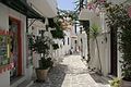 A street in Parikia, Paros
 -
 Naoussa, Paros
 -
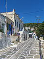
 Street in Naoussa, Paros
 -
 Naoussa, Paros
 -
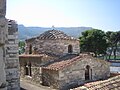
 Church in Lefkes
 -
 Lefkes, Paros, Greece.
 -
 Paros, Antiparos & Despotiko islands
 -
 Church of the 100 doors (Ekatontapyliani), Baptistery, Parikia
 -
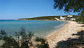 Alyki, Paros
 -
 Old lighthouse on the island of Paros


See also
- Communities of the Cyclades
- Aegean Center for the Fine Arts
- Pounta
References
- Notes
- ^ "Αποτελέσματα Απογραφής Πληθυσμού - Κατοικιών 2021, Μόνιμος Πληθυσμός κατά οικισμό" [Results of the 2021 Population - Housing Census, Permanent population by settlement] (in Greek). Hellenic Statistical Authority. 29 March 2024.
- ^ a b c d e f g h i j k l m n o p q r s t u v w x y z aa ab ac ad ae af Chisholm, Hugh, ed. (1911). . Encyclopædia Britannica. Vol. 20 (11th ed.). Cambridge University Press. pp. 860–861.
- ^ "Population & housing census 2001 (incl. area and average elevation)" (PDF) (in Greek). National Statistical Service of Greece.
- ^ Lund University. Digital Atlas of the Roman Empire.
- ^ "Parian – definition of Parian by the Free Online Dictionary, Thesaurus and Encyclopedia". Thefreedictionary.com. Retrieved 2009-05-06.
- ^ Heraclides De rebus publicis 8
- ^ Stephanos Byz.
- ^ Schol. Dionysius Periegetes 525; Herodian I.171
- ^ Thucydides Peloponnesian War IV.104; Strabo Geography 487
- ^ Zafeiropouloy F., and A., Agelarakis “Warriors of Paros”, Archaeology 58.1(2005): 30–35.
- ^ Diodorus Siculus XV.13
- ^ Herodotus Histories V.31
- ^ Herodotus op.cit. VI.133–136
- ^ Herodotus op.cit. VIII.67
- ^ Herodotus op.cit. VIII.112
- ^ Olympiodorus 88.4
- ^ Corpus Inscriptionum Graecarum 2376–2383; Ross, Inscr. med. II.147, 148
- ^ Diodorus Siculus XIII.47
- ^ "Ferry Disaster off Paros". Greek Island Hopping. Archived from the original on January 20, 2011. Retrieved April 1, 2011. ()
- ^ Inscriptiones Graecae XII.100 seqq.
- ^ Pliny the Elder Historia Naturalis XXXVI. 5, 14; Plato Eryxias, 400 D; Athenodorus V.205 f; Diodorus Siculus 2.52
- ^ “Next morning we went in a tram drawn by horses up to the quarry of marble... We were received by the engineer who took us down the quarry. We all had miners’ lamps, not very light to hold, and scrambled and slipped and crawled through the various passages up and down… At the entrance is a bas-relief of figures dedicated to the Nymphs. It is carefully covered with wood. The middle figures have been removed by someone...” Extract from The Travel Chronicles of Mrs J. Theodore Bent, Vol. 1 (2006, Oxford, p.22). See also, Theodore Bent, The Cyclades, or Life Among the Insular Greeks (1885, London, pp.372 ff.).
- Sources
- Clarke Travels III (London, 1814)
- de Tournefort, J.R. Voyage du Levant I.232 seqq. (Lyon, 1717)
- Leake, William Martin, Travels in Northern Greece III.84 seqq. (London, 1835)
- Where to stay in Paros, Thanasis Mougios (which owns "KingLIke Concierge")
External links
 Definitions from Wiktionary
 Media from Commons
 News from Wikinews
 Quotations from Wikiquote
 Texts from Wikisource
 Textbooks from Wikibooks
 Resources from Wikiversity
 Media related to Paros at Wikimedia Commons
 Paros travel guide from Wikivoyage
- Website of the municipality of Paros
- Moving Postcards Paros
- Church of Ekatontapyliani (Church of a Hundred Doors)
- Folklore Art Museum of Cycladic Civilization by Benetos Skiadas.GR