
Peabody, Massachusetts
Peabody | ||
|---|---|---|
City | ||
 Peabody City Hall in 2021 | ||
|
FIPS code 25-52490 | | |
| GNIS feature ID | 0614307 | |
| Website | www | |
Peabody (
History
The area was long inhabited by Native American people known as the Naumkeag.[3][4][5]
The area was settled as part of Salem in 1626 by a small group of English colonists from Cape Ann led by Roger Conant. It was subsequently referred to as the Northfields, Salem Farms, and Brooksby.[6] Several area residents were accused of witchcraft during the Salem witch trials of the late 17th century, three of whom were executed (John Proctor, Giles Corey, and Martha Corey).[7]
In 1752, the area was set off from
Peabody started off as a
By 1915, one-third of the population had been born outside the United States.
On the morning of October 28, 1915, twenty-one young children were killed in the
The tanneries that lined Peabody's "Ottoman Street" remained a linchpin of the city's economy into the second half of the 20th century. The tanneries have since closed or been relocated elsewhere, but the city remains known locally as the Leather City or Tanner City. The mascot of Peabody Veterans Memorial High School is named the Tanners.
The loss of the tanneries was a huge blow to Peabody's economy, but the city has made up for the erosion of its industrial base, at least in part, through other forms of economic development. Early in the 20th century, Peabody joined the
The
Peabody is also the location of the Salem Country Club, a privately owned country club with a professional golf course, which hosted the U.S. Senior Open in 2001 and 2017, and the U.S. Women's Open in 1954 and 1984.
-
 City Hall in 1912
 -
 Peabody Square, c. 1906
 -
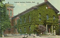 Peabody Institute Library, c. 1912
 -
 Independence Greenway
 -
 The former tanneries of Peabody
 -
 George Peabody, the city's namesake


Geography
Peabody is located at 42°32′3″N 70°57′41″W / 42.53417°N 70.96139°W (42.534045, −70.961465).[14] According to the United States Census Bureau, the city has a total area of 16.8 square miles (43.5 km2), of which 16.2 square miles (42.0 km2) is land and 0.58 square miles (1.5 km2) or 3.46%, is water.[15] The northwestern border of Peabody lies along the Ipswich River, with brooks feeding it, and the Waters River, a tributary of the Danvers River, drains the northeast part of town. Several other ponds and a portion of Suntaug Lake lie within town. The largest protected portion of the city is the Brooksby Farm, whose land includes the Nathaniel Felton Houses.
The city is wedge-shaped, with the city center located in the wider northeast end. The neighborhood of South Peabody lies south of it, and the more suburban neighborhood of West Peabody, where the high school is, lies to the west of the city center, separated by the highways and the Proctor neighborhood. Peabody's center is 2 miles (3 km) from the center of Salem, 15 miles (24 km) northeast of Boston, 18 miles (29 km) west-southwest of Gloucester, and 18 miles (29 km) southeast of Lawrence. Peabody is also bordered by Middleton to the northwest, Danvers to the north, Salem to the east, Lynn to the south and Lynnfield to the southwest.
Demographics
| Year | Pop. | ±% |
|---|---|---|
As of the census of 2010,
The city has had a very large Greek population ever since the early 20th century. Ever since the mid 20th century, the Portuguese population has been very present, especially from the Azores. In the 21st century, Brazilians came in large swathes.
There were 21,313 households, of which 26.8% included children under the age of 18, 48.4% were married couples living together, 10.7% had a female householder with no husband present, and 37.1% were non-families. Of all households, 31.4% were made up of individuals, and 16.3% had someone living alone who was 65 years of age or older. The average household size was 2.28, and the average family size was 3.02.
In the city, the population was spread out, with 21.1% under the age of 20, 22.5% from 20 to 39, 29.8% from 40 to 59, and 26.5% who were 60 years of age or older. The median age of people in Peabody was 44.6. For every 100 females, there were 90.3 males. For every 100 females age 18 and over, there were 86.9 males.
The median income for a household in the city was $65,515, and the median income for a family was $80,471. Males had a median income of $55,352 versus $44,167 for females. About 4.4% of families and 6.3% of the population were below the
In the April 2009 edition of Forbes magazine, Peabody was ranked the 14th most livable city in the United States.[26]
Government
Peabody is represented in the state legislature by officials elected from the following districts:
- Massachusetts Senate's 2nd Essex district[27]
- Massachusetts House of Representatives' 12th Essex district[28]
- Massachusetts House of Representatives' 13th Essex district
Economy

- Major employers
- Analogic Corporation
- Boston Children's Hospital
- Boston Acoustics
- Carl Zeiss AG
- Christian Book Distributors
- JEOL
- Lahey Hospital & Medical Center
- Meridian Interstate Bancorp
- Northshore Mall
- Rousselot Gelatine (formerly a division of Kodak)
- Saucony
- UTC Aerospace Systems
Education
- Peabody Veterans Memorial High School, a grade 9–12 public high school serving Peabody residents. The athletic teams are known as the Peabody Tanners. As of April 2008, there were 1,898 students enrolled in the school, and 146 teachers.[29]
- Bishop Fenwick High School, a Catholic private high school serving the entire North Shore region, is located in the city near the boundary with Salem, Danvers, and Beverly. As of 2017, enrollment is just under 600 students.
- J. Henry Higgins Middle School, a grade 6–8 public middle school, with a hawk as its mascot.
- Covenant Christian Academy, a Christian and classical preparatory school for students Pre-K through 12th grade. Moved into the old John F. KennedyJunior High School in West Peabody in 2005. They serve students from over 45 cities and towns in eastern Massachusetts.
- St. John the Baptist School, a private Catholic school that teaches up to grade 8. It currently has approximately 400 students.
- Peabody P.R.E.P. Personalized Remote Education Program
Public elementary schools
- Captain Samuel Brown Elementary
- John E. Burke Elementary
- Thomas Carroll Elementary
- Center Elementary
- John E. McCarthy Elementary
- South Memorial Elementary
- William A. Welch Elementary
- West Memorial Elementary[30]
Infrastructure
Transportation
Peabody is the site of the large intersection of Interstate 95, Massachusetts Route 128, Massachusetts Route 129 and U.S. Route 1. Route 1 heads north–south through the city as the main route between Boston and its northeast suburbs, and Route 129 is an east–west surface route that runs concurrently with Route 1 in the neighboring community of Lynnfield. I-95 and Route 128 share a 37-mile long concurrency as a half beltway around Boston, but in Peabody, the two highways split, with Interstate 95 going north into New Hampshire and Route 128 going east towards Gloucester and Cape Ann. Massachusetts Route 114 passes through the northeast corner of town, going from Danvers towards Salem, with an intersection at Route 128's Exit 25, next to the Northshore Mall. The southern terminus of Route 35 is at Route 114, just a half mile before Route 114 enters Salem.
Several lines of the
Utilities
The municipally-owned Peabody Municipal Light Plant provides electricity to the city. Natural gas service in Peabody is provided by National Grid. Cable television in Peabody is provided by Comcast and the City in June 2019 issued a second Cable TV license to RCN.[31][32]
Notable people
- Florida Marlinsfrom 2003 to 2011
- Daniel Ankeles, Maine state senator
- Matt Antonelli, former second basemen for the San Diego Padres of Major League Baseball
- Olympicswimmer champion
- Garcelle Beauvais, actress and author
- Frederick Berry, disability rights advocate, state senator from 1983 to 2013, majority leader of the Massachusetts State Senatefrom 2003 to 2013
- Matt Bloom, professional wrestler
- Nathaniel Bowditch, early American astronomer, mathematician, and navigator
- Patrick Francis Bresnahan, United States Navy veteran, Medal of Honor
- Emma Southwick Brinton, American Civil War army nurse, traveler, and foreign correspondent
- Kimberly S. Budd, Chief Justice of the Massachusetts Supreme Judicial Court
- Bobby Carpenter, NHL player in the 1980s and 1990s
- Giles Corey, victim of the Salem witch trials
- Martha Corey, victim of the Salem witch trials
- Chick Davies, Major League Baseball player
- Brad Delp, lead singer of the band Boston
- Jerry DeLucca, former professional football player in New England Patriots
- Mary Upton Ferrin, American suffragette and women's rights advocate
- Bob Franke, singer-songwriter
- Gary Gulman, comedian
- Hrishikesh Hirway, musician, producer, host of Song Exploder , and vocalist of The One AM Radio
- Daniel P. King, congressman from 1843 to 1850
- Christina Kirkman, teen actress, comedian, and circus performer
- Joe Klein, author, journalist (worked for The Peabody Times in the 1970s)
- Steve Lomasney, former Major League Baseball player
- David A. Lowy, Associate Justice of the Massachusetts Supreme Judicial Court
- Heather MacLean, competitive runner; competed at 2020 Summer Olympics[33]
- Nicholas Mavroules, mayor from 1967 to 1978, congressman 1979 to 1993
- Ryan Montbleau, professional musician
- Jonathan Mover, professional drummer
- George Peabody, merchant, philanthropist, and namesake of the city
- Marc Predka, rapper known as Tha Trademarc
- John Proctor, victim of the Salem witch trials
- Patricia Goldman-Rakic, pioneering neuroscientist and professor
- Ruth Shoer Rappaport, scientist and vaccine researcher
- Charles Rosa, MMA fighter
- Pauline Sperry, mathematician
- John J. Studzinski, Investment banker and philanthropist
- John Tudor, Major League Baseball pitcher from 1979 to 1990
- Francis Robbins Upton, physicist and mathematician
- Rochelle Walensky, physician-scientist, director of the Centers for Disease Control and Prevention from 2021 to 2023
- Jack Welch, industrialist
- Nancy Werlin, book author
References
- Epodunk, accessed April 16, 2007.
- ^ "2020 U.S. Gazetteer Files". United States Census Bureau. Retrieved May 21, 2022.
- ^ "The Naumkeag". PIONEER VILLAGE. Retrieved December 28, 2020.
- ^ Writer, Dustin Luca Staff (October 24, 2019). "President Jackson's portrait to make way for Naumkeag leader". Salem News. Retrieved December 28, 2020.
- ^ "MASSACHUSETTS INDIGENOUS COMMUNITY RESOURCES". Salem Historical Society. Retrieved December 28, 2020.
- ^ "History | Peabody Historical Society". Retrieved December 28, 2020.
- ^ "Welcome to Peabody". Salem Witch Museum. Retrieved December 28, 2020.
- ^ .
- ^ Gendisasters.com Archived 2007-12-05 at the Wayback Machine
- ^ NFPA.org Archived 2007-09-30 at the Wayback Machine
- ^ Clymer, Floyd. Treasury of Early American Automobiles, 1877-1925 (New York: Bonanza Books, 1950), p.158.
- ^ "Peabody-works.com". Archived from the original on October 26, 2017. Retrieved January 24, 2008.
- ^ Essexheritage.org Archived 2007-12-22 at the Wayback Machine
- ^ "US Gazetteer files: 2010, 2000, and 1990". United States Census Bureau. February 12, 2011. Retrieved April 23, 2011.
- ^ a b "Geographic Identifiers: 2010 Demographic Profile Data (G001): Peabody city, Massachusetts". American Factfinder. U.S. Census Bureau. Archived from the original on February 13, 2020. Retrieved February 10, 2016.
- ^ "TOTAL POPULATION (P1), 2010 Census Summary File 1, All County Subdivisions within Massachusetts". United States Census Bureau. Archived from the original on February 12, 2020. Retrieved September 13, 2011.
- ^ "Massachusetts by Place and County Subdivision - GCT-T1. Population Estimates". United States Census Bureau. Archived from the original on February 12, 2020. Retrieved July 12, 2011.
- ^ "1990 Census of Population, General Population Characteristics: Massachusetts" (PDF). US Census Bureau. December 1990. Table 76: General Characteristics of Persons, Households, and Families: 1990. 1990 CP-1-23. Archived from the original (PDF) on December 7, 2013. Retrieved July 12, 2011.
- ^ "1980 Census of the Population, Number of Inhabitants: Massachusetts" (PDF). US Census Bureau. December 1981. Table 4. Populations of County Subdivisions: 1960 to 1980. PC80-1-A23. Retrieved July 12, 2011.
- ^ "1950 Census of Population" (PDF). Bureau of the Census. 1952. Volume 1: Number of Inhabitants, Section 6, Pages 21-10 and 21-11, Massachusetts Table 6. Population of Counties by Minor Civil Divisions: 1930 to 1950. Retrieved July 12, 2011.
- ^ "1920 Census of Population" (PDF). Bureau of the Census. Number of Inhabitants, by Counties and Minor Civil Divisions. Pages 21-5 through 21-7. Massachusetts Table 2. Population of Counties by Minor Civil Divisions: 1900, 1910, and 1920. Retrieved July 12, 2011.
- ^ "1890 Census of the Population" (PDF). Department of the Interior, Census Office. Pages 179 through 182. Massachusetts Table 5. Population of States and Territories by Minor Civil Divisions: 1880 and 1890. Retrieved July 12, 2011.
- ^ "1870 Census of the Population" (PDF). Department of the Interior, Census Office. 1872. Pages 217 through 220. Table IX. Population of Minor Civil Divisions, &c. Massachusetts. Retrieved July 12, 2011.
- ^ "City and Town Population Totals: 2020−2022". United States Census Bureau. Retrieved November 24, 2023.
- ^ "Census of Population and Housing". Census.gov. Retrieved June 4, 2015.
- ^ Forbes.com
- ^ Massachusetts General Court, "An Act Establishing Executive Councillor and Senatorial Districts", Session Laws: Acts (2011), retrieved August 23, 2020
- ^ "Massachusetts Representative Districts". Sec.state.ma.us. Retrieved August 23, 2020.
- ^ Public Schools of Peabody Massachusetts
- ^ Schools, PBD. "Peabody Public Schools". Retrieved March 12, 2023.
- ^ "Second cable provider coming to Peabody". Salem Evening News.
- ^ MassUtilities (Map). MassGIS. Retrieved November 22, 2017.
- ^ Minton, Sam; Tobin, Anne Marie (September 5, 2021). "Heather MacLean Day takes over Peabody". The Daily Item.
External links
Municipalities and communities of Essex County, Massachusetts, United States | ||
|---|---|---|
| Cities |  | |
| Towns | ||
| CDPs | ||
| Other villages |
| |
| ||
Boston (capital) | |
| Topics | |
| Society |
|
| Regions | |
| Counties | |
| Cities |
|
| International | |
|---|---|
| National | |
| Geographic | |