
Pha That Luang


Pha That Luang (
History

Buddhist missionaries from the
In the mid-16th century, King
In 1641, a Dutch envoy of the Dutch East India Company, Gerrit van Wuysthoff, visited Vientiane and was received by King Sourigna Vongsa at the temple, reportedly in a magnificent ceremony. He wrote that he was particularly impressed by the "enormous pyramid...and the top was covered with gold leaf weighing about a thousand pounds".[4] The stupa was repeatedly plundered by the Burmese, Siamese, and Chinese.[3]
Pha That Luang was destroyed by the Thai
Architecture
The architecture of the building includes many references to Lao culture and identity, and so has become a symbol of Lao nationalism.
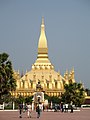
The first level is 223 by 226 feet (68 by 69 metres); the second is 157 feet (48 metres) along each side; and the third level is 98 feet (30 metres) along each side.[3] From ground to pinnacle, Pha That Luang is 147.6 feet (45.0 metres) high.[3]
Only the pinnacle is covered in real gold; the remainder of the stupa is painted a gold color.
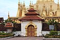
The area around Pha That Luang is now gated, to keep out traffic. Previously, visitors could drive around the whole complex. The encircling walls are roughly 279 feet (85 metres) long on each side and contain a large number of Lao and Khmer sculptures, including one of Jayavarman VII.[3]
Gallery
-
 Pha That Luang stupa
 -
 View of the stupa from inside the temple
 -
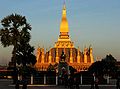 The national symbol of Laos at sunset
 -
 Nāga inside the temple
 -
 That Luang Festival (2010)
 -
 Thatluang Festival (2010)
 -
 That Luang stupa at night
 -
 That Luang
 -
 King Jayavarman VII of the Khmer Empire
 -
 Naga Pagoda of west Pha That Luang, October 2006

_I.jpg)

_II.jpg)


See also
References
- ^ Foreman, William (28 December 2004). "Laos: A day in Vientiane is full of temples, colonial architecture and surprises". USA Today / AP. Retrieved 22 May 2010.
- ^ a b c d "Half Day Tour in Vientiane". Lasi Global. 1 May 2009. Retrieved 26 September 2009.
- ^ a b c d e f g "Pha That Luang (built 1566, reconstructed 1930)". Asian Historical Architecture. Retrieved 26 September 2009.
- ISBN 1-74104-086-8.
External links
![]() Media related to Pha That Luang, Vientiane at Wikimedia Commons
Media related to Pha That Luang, Vientiane at Wikimedia Commons