
Philadelphia Koreatown
Koreatown | |
|---|---|
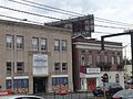
 Professional offices along Cheltenham Avenue in Cheltenham, one of several areas in the Delaware Valley encompassing Greater Philadelphia that has a significant Korean population. In the background is the northern terminus of Broad Street. | |
 Koreatown | |
| Coordinates: 40°02′02″N 75°07′16″W / 40.034°N 75.121°W | |
| Country | United States |
| State | Pennsylvania |
| County | Philadelphia |
| City | Philadelphia |
| Area code(s) | 215, 267 and 445 |

The first Philadelphia Koreatown (
is ubiquitous in some neighborhoods in these areas.History
According to The Philadelphia Inquirer, the Koreatown had "moved" from the Logan neighborhood into the Olney section in the early 1980s, attributing the migration from Logan to "too much crime" and the "schools weren't so good" at the time in Logan.[6] In Olney, tensions were high between Koreans and the German community,[6] as well as the black community, who did not want the section of the town to be officially declared "Koreatown", causing much violence and crime to be committed not only against Koreans, but East Asians in general.[7] The original Koreatown existed on North 5th Street in Olney since 1984, with Korean language signs put up to help official recognition of the area; those signs were vandalized in the late 1980s.[1]
Religion
There is a Korean Catholic church, Holy Angels.[8]
See also
- Koreatown
- Korean American
- Chinatown, Philadelphia
- Little Saigon, Philadelphia
- Cambodia Town, Philadelphia
- Upper Darby Township, Pennsylvania
- Millbourne, Pennsylvania
- Cheltenham Township, Pennsylvania
- Cherry Hill, New Jersey
- Koreatown, Palisades Park (벼랑 공원 코리아타운)
- Koreatown, Fort Lee (포트 리 코리아타운)
- List of U.S. cities with significant Korean-American populations
Gallery
-
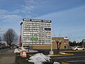
 View towards Market Street PA route 3, across fromH-Mart, at Terminal Square. The 69th Street Transportation Centeris also nearby.
 -
 H-Martin Upper Darby Township, Pennsylvania
 -
 H-Martand other Korean-American businesses in Cheltenham
 -
 More Korean businesses in Cheltenham


References
- ^ ISBN 9780815331186.
- ^ Catherine Laughlin (April 10, 2012). "A sandwich With a Little Bit of Seoul - The Koagie comes to Cherry Hill". New Jersey Monthly. Retrieved January 16, 2023.
- ^ "ACS DEMOGRAPHIC AND HOUSING ESTIMATES - 2009-2013 American Community Survey 5-Year Estimates - Cherry Hill township, Camden County, New Jersey". United States Census Bureau. Archived from the original on April 27, 2015. Retrieved April 26, 2015.
- ^ "Profile of General Population and Housing Characteristics - Cherry Hill township, Camden County, New Jersey - 2010 Demographic Profile Data". United States Census Bureau. Archived from the original on February 12, 2020. Retrieved April 26, 2015.
- ^ Richard Manfredi, Demand Media. "Korean Restaurants in Cherry Hill, New Jersey". USA TODAY. Retrieved April 26, 2015.
- ^ a b Marc Kaufman (July 13, 1986). "'Koreatown': From Logan Into Olney". The Philadelphia Inquirer. Retrieved April 26, 2015.
- ISBN 9780549387824.
- ^ "Holy Angels (Korean)". Roman Catholic Archdiocese of Philadelphia. Retrieved 2020-04-22.
External links
|