
Pico Island
Native name: Ilha do Pico Nickname: The Black Island | |
|---|---|
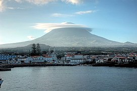
.jpg) The island of Pico, as seen from the north-west coast in the outskirts of Madalena with vineyards and Mount Pico in the background | |
 Location of the island of Pico in the archipelago of the Azores | |
| Etymology | Portuguese for peak |
| Geography | |
| Location | Atlantic Ocean |
| Coordinates | 38°27′57″N 28°20′0″W / 38.46583°N 28.33333°W |
| Archipelago | Azores |
| Area | 444.97 km2 (171.80 sq mi)[1] |
| Area rank | 3rd largest island in Portugal |
| Coastline | 151.84 km (94.349 mi)[1] |
| Highest elevation | 2,351 m (7713 ft)[1] |
| Highest point | Mount Pico |
| Administration | |
| Autonomous Region | Azores |
| Municipalities | |
| Demographics | |
| Demonym | Picoense, Picaroto |
| Population | |
| Pop. density | 31/km2 (80/sq mi) |
| Languages | Portuguese |
| Ethnic groups | Portuguese |
| Additional information | |
| Time zone | |
Pico Island (Ilha do Pico, Portuguese pronunciation: [ˈiʎɐ ðu ˈpiku]) is an island in the Central Group of the Portuguese Azores. The landscape features an eponymous volcano, Ponta do Pico, which is the highest mountain in Portugal, the Azores, and the highest elevation of the Mid-Atlantic Ridge. In the tradition of the Portuguese poet, Raul Brandão, Pico is referred to as the Ilha Preta ("Black Island"), for its black volcanic soils, which nourish its UNESCO-designated vineyards that once allowed the development of the island's economy. Pico is the second largest and, geologically speaking, the most recently formed island of the Azores, being around 300,000 years old.[3]
History


The exact date of the island's discovery is not known. However, in the 1375 Catalan Atlas, Pico is depicted along several other islands of the Azores, where it is labelled as li colunbj. In Cristoforo Soligo's map from 1475, Pico is described both as Dom Diniz (or São Diniz) island and as Insula Columbi.[4]
Although the Azores were inhabited since 1439, settlement on Pico only started in the 1480s when Pico became part of the neighboring island of Faial's control. Pico is thought to be the last of the islands of the Central Group to be occupied.[5]
In a letter dated March 28, 1481, the administrator of the Azores,
Population grew slowly, in part because of difficulties cultivating wheat. By 1587, there were less than 3,000 inhabitants.
Aside from a few slaves sent to herd sheep in isolation before European settlement, the island's first inhabitants were primarily Portuguese, but of diverse origins.) proves this).
Around 9,000 lived on Pico by 1695. Pico moved "up the ladder" of urban hierarchies from fifth largest centre in the Azores to fourth, behind
The islands of Pico and Faial were administered jointly until 1766, when Pico became an integral part of the Province of the Azores, led by a captain-general based in Angra. Centralizing governance in this way had poor success: in 1836, the people of Pico were integrated into a smaller administrative unit again, the third Azorean district, with the islands of Faial, Flores and Corvo.[6]

Settlers initially farmed wheat and some olives in addition to developing a
The other major economic activity was whaling. The presence of American and British whalers in the waters of the Azores at the end of the 18th century stabilized the economy.
Geography
Physical geography
.jpg)
.jpg)
,_Pico_Island,_Azores,_Portugal_(PPL1-Corrected)_5_julesvernex2.jpg)

The island is 17.5 km south of
Along the central plain of volcano cones to the eastern coast, the landscape is pitted with the remnants of craters and lake-filled cones, and dominated by the ancient volcano of Topo. Geomorphologically, the island is composed of three units:[11][12]
- Topo Volcano - Located on the southernmost side of the island, it corresponds to an ancient shield volcano created by the overlap of various lava flows and destroyed by erosion and landslides;
- Achada Plateau - Extending from the east side of the island to the stratovolcano, the Achada Plateau is an axial zone comprising spatter and lava cones along a mountainous ridge filled with lake-filled craters, dense scrub and forests. Cones in this region are oriented along a west-northwest and south-southeast axis along a path east to west between the other volcanic structures;
- Pico Volcano - It occupies the western portion of the island, and corresponds to a central volcano with 2,351 m (7,713 ft) in altitude, created by numerous Hawaiian and Strombolian eruptions. Along its flanks are diverse lava and spatter cones that are formed along radial fractures and faults.
Generally, Pico Island's tectonic structures are oriented along a west-northwest to east-southeast and a northeast to southwest axis. The main axis controls the main structures, especially the main mountain of Pico, while the secondary axises affect the radial fractures and faults along the central plain and eastern volcano.
Similar to the geomorphological structures described above, the volcanic landforms have been identified by Madeira (1998) in the following units:[13]
- Volcanic Complex of Lajes - pertains to the oldest volcanic structures, comprising volcanoes, lavas and debris that are between 35 and 300,000 thousand years old; it makes up the structures of the eastern part of the island, including the ancient volcano of Topo.
- Volcanic Complex of Calheta de Nesquim - dating to about 230,000 thousand years ago, this is a fissural zone of cones and basaltic lavas, associated with the Achada Plain, and the many faults along the central plateau of the island.
- Volcanic Complex of Madalena - the most recent volcanic complex, with both geological and historical eruptions; it includes the basaltic stratovolcano of Pico, but also many of the cones, faults and lava fields that circle the 2,351 meter summit.
The last volcanic eruption (which is debatable) occurred in 1963, in a small submarine eruption off the northwest coast (north of Cachorro in Santa Luzia). Prior to this, major volcanic activity was evident in lava fields generated in only the areas of Prainha (1562–64), Santa Luzia (1718), São João (1718) and Silveira (1720). The paths of the lava flows are still visible; those in the 16th century and 1718 were particularly substantial, extending for over 10 km. Today, the only visible evidence of active volcanism appears on the summit of Pico, in the base and interior of the Piqueninho (the mini-peak on the summit); there are irregular emissions from cracks in this zone. Additionally, there are emissions on the eastern flanks between 1500 and 2000 meters altitude. There have also been found areas of de-gasification along the fault associated with the Lagoa do Capitão and another in the Topo Volcano, as well as a spring rich in CO2 in the area of Silveira.
Earthquakes
Pico, much like the other islands, is susceptible to seismic events, although their epicenters have primarily been localized in the
Biome
.jpg)
According to the 2018 land occupation chart of the Azores, compared to the other islands of the archipelago, Pico has, both by proportion and total land area, the largest area of intact native
Like the remaining islands of the Azores, Pico suffered extensive deforestation following its occupation. While some land, especially at the coast, was used for housing, the majority was and is still used for farming, livestock and the wood industry (of Cryptomeria). Additionally, several introductions of exotic species in the 19th century, like Hydrangea macrophylla, Pittosporum undulatum, Hedychium gardnerianum and Psidium cattleyanum, resulted in invasion and destruction of the remaining native habitats.
Gaspar Frutuoso gave a brief description of the island's flora only a century after being occupied:
"All around the island there is plenty and large wood of cedar [
Morella faya], laurels [Laurus azorica], and above all, the yew wood [Taxus baccata], found solely on Pico [...] It has many groves: Cedar, pau branco, laurel, faia, tamujo [Myrsine africana], heaths [Erica azorica] as large as trees, sanguinhos, zimbro and laurustinus [Viburnum treleasei] [...]"— Gaspar Frutuoso, late 16th century, Saudades da Terra, Book VI[15]
Over a third of the Natura 2000 protected areas of the Azores are located on Pico. It has also the largest number of volcanic cavities (lava caves) of anywhere in the archipelago, 86 out of 225.[16]
Climate
Pico, like the remaining islands of the archipelago, has a mild maritime climate with high precipitation for most of the year, high humidity and constant winds. However, due to its unusual topographic variation, temperature and precipitation levels vary significantly depending on both altitude and location (generally, rainfall is more concentrated in the east). Temperatures vary around 8 °C between the coolest and the warmest month (February and August respectively)
At lower elevations, where most of the population resides, Pico has a
At higher elevations, like the Achada Plateau, temperatures are cooler and precipitation increases, it therefore transitions into a wet oceanic climate (Köppen: Cfb; Thornthwaite: A), average relative humidity stays around 90%[19][6] and fogs produced by the cooling of rising air masses from the ocean are persistent, which, in turn, creates an environment typical of a cloud forest. Places such as the Caiado and Paul lakes receive, respectively, 4,698 and 3,357 millimetres (185.0 and 132.2 in)[21] of precipitation each year and Mount Pico is recognized as receiving the largest annual rainfall in Portugal (over 5,000 mm (200 in) per year at the northeastern flanks of the volcano).
At around 1,200 m (3,900 ft), the climate becomes
Pico has registered the highest temperature ever recorded in the Azores, 32.1 °C (89.8 °F) on 7 September 1985 at Pico Airport[22] and although there are no climatic stations at Mount Pico, it is likely that the island has also experienced the lowest temperatures in the archipelago at the top of the mountain.
| Climate data for Pico Airport, Bandeiras, Madalena, Pico Island, Azores | |||||||||||||
|---|---|---|---|---|---|---|---|---|---|---|---|---|---|
| Month | Jan | Feb | Mar | Apr | May | Jun | Jul | Aug | Sep | Oct | Nov | Dec | Year |
| Mean daily maximum °C (°F) | 16.6 (61.9) |
16.2 (61.2) |
16.7 (62.1) |
17.6 (63.7) |
19.3 (66.7) |
21.6 (70.9) |
24.1 (75.4) |
25.3 (77.5) |
24.2 (75.6) |
21.6 (70.9) |
19.1 (66.4) |
17.5 (63.5) |
20.0 (68.0) |
| Daily mean °C (°F) | 14.5 (58.1) |
13.9 (57.0) |
14.4 (57.9) |
15.2 (59.4) |
16.7 (62.1) |
19.0 (66.2) |
21.3 (70.3) |
22.4 (72.3) |
21.4 (70.5) |
19.2 (66.6) |
16.9 (62.4) |
15.4 (59.7) |
17.5 (63.5) |
| Mean daily minimum °C (°F) | 12.4 (54.3) |
11.7 (53.1) |
12.2 (54.0) |
12.8 (55.0) |
14.2 (57.6) |
16.4 (61.5) |
18.5 (65.3) |
19.6 (67.3) |
18.7 (65.7) |
16.8 (62.2) |
14.8 (58.6) |
13.4 (56.1) |
15.1 (59.2) |
| Average rainfall mm (inches) | 109.5 (4.31) |
113.8 (4.48) |
97.0 (3.82) |
68.1 (2.68) |
77.0 (3.03) |
35.9 (1.41) |
31.2 (1.23) |
63.0 (2.48) |
91.4 (3.60) |
130.6 (5.14) |
147.3 (5.80) |
144.2 (5.68) |
1,109 (43.66) |
| Average relative humidity (%)
|
80 | 80 | 80 | 79 | 81 | 81 | 80 | 80 | 80 | 79 | 80 | 81 | 80 |
| Source 1: climate-data.org[23] | |||||||||||||
| Source 2: | |||||||||||||
| Climate data for Cabeço do Teicho, 2017-2021, altitude: ~ 850 m (2,790 ft) | |||||||||||||
|---|---|---|---|---|---|---|---|---|---|---|---|---|---|
| Month | Jan | Feb | Mar | Apr | May | Jun | Jul | Aug | Sep | Oct | Nov | Dec | Year |
| Record high °C (°F) | 18.6 (65.5) |
20.5 (68.9) |
19.3 (66.7) |
18.2 (64.8) |
21.5 (70.7) |
21.0 (69.8) |
23.9 (75.0) |
25.0 (77.0) |
23.0 (73.4) |
23.4 (74.1) |
19.2 (66.6) |
18.3 (64.9) |
25.0 (77.0) |
| Mean daily maximum °C (°F) | 12.0 (53.6) |
12.1 (53.8) |
12.1 (53.8) |
12.6 (54.7) |
14.8 (58.6) |
16.3 (61.3) |
19.5 (67.1) |
20.4 (68.7) |
18.6 (65.5) |
16.7 (62.1) |
13.8 (56.8) |
12.6 (54.7) |
15.1 (59.2) |
| Daily mean °C (°F) | 10.0 (50.0) |
8.8 (47.8) |
9.1 (48.4) |
9.9 (49.8) |
11.6 (52.9) |
13.2 (55.8) |
16.3 (61.3) |
17.2 (63.0) |
15.7 (60.3) |
14.0 (57.2) |
11.4 (52.5) |
10.2 (50.4) |
12.3 (54.1) |
| Mean daily minimum °C (°F) | 7.7 (45.9) |
5.8 (42.4) |
6.5 (43.7) |
7.3 (45.1) |
8.6 (47.5) |
10.1 (50.2) |
13.0 (55.4) |
14.3 (57.7) |
13.1 (55.6) |
11.5 (52.7) |
9.1 (48.4) |
7.7 (45.9) |
9.6 (49.2) |
| Record low °C (°F) | 1.6 (34.9) |
1.3 (34.3) |
2.1 (35.8) |
2.7 (36.9) |
2.7 (36.9) |
4.2 (39.6) |
7.8 (46.0) |
8.5 (47.3) |
8.9 (48.0) |
6.5 (43.7) |
3.9 (39.0) |
2.2 (36.0) |
1.3 (34.3) |
| Average precipitation mm (inches) | 636.9 (25.07) |
426.8 (16.80) |
275.3 (10.84) |
358.7 (14.12) |
275.3 (10.84) |
157.3 (6.19) |
83.1 (3.27) |
243.8 (9.60) |
270.0 (10.63) |
384.6 (15.14) |
581.5 (22.89) |
498.1 (19.61) |
4,191.4 (165) |
| Average relative humidity (%)
|
90 | 87 | 91 | 91 | 89 | 90 | 88 | 91 | 91 | 91 | 93 | 91 | 90 |
| Source: Direção Regional do Ambiente[25] | |||||||||||||
Human geography
Geological, geomorphological and climatic constraints played (and still have) a determining role in economic activity, in the distribution of urban agglomerations and in demographic evolution. The settlement pattern is a good example of the native's adaptation to the specific physical geography of this island, developing mainly along the coast and along the roads of communication. The main urban centers, municipality seats, are located by the sea:
Regarding demographic behavior, the population has continued to decline since the middle of the last century, a trend that continues to the present day. However, the 1960s and 1970s were the decades that showed a more negative population variation rate, due to the intense emigration surge that was generated at this time and that was generalized to the entire archipelago. Unlike other islands in the Azores, in the 1990s the situation did not change, continuing to register a negative population variation (-2.6%), even higher than that registered in the 1980s. According to the XIV General Census of Population (INE, 2002), the population totaled 14,806 inhabitants, which represents a decrease of 396 inhabitants compared to 1991. In 2001, the municipality of Madalena had the largest population (6,136 individuals), followed by Lajes do Pico (5,041 individuals) and São Roque (3,629 individuals). The population density (33.3 inhabitants/km2) was among the lowest in the archipelago and the age structure showed signs of aging, with more than 50% of the population aged between 25 and 64 years, against 30% of young people and about 20% of seniors.[6]
As of 2021, the total population is estimated to be around 13,895 inhabitants.[2]
-
 The village of Madalena at the western base of Mount Pico, as seen from the Faial-Pico Channel
 -
 Lajes do Pico, along the south-central coast, with Mount Pico in the distance
 -
 The port and historic centre of the civil parish of São Roque, showing the whaling museum, and former rendering factory along the coast
 -
 East side of the island, viewed from Mount Pico


Economy

Historically, Pico was largely dependent on Faial for its economic, political and social activities, and it still is to this day, although mitigated by the entrepreneurial dynamics of its population and by the centralities created by the autonomous regime. The close relations with the neighboring island are still established in the maritime routes that cross the channel daily. Fishing is one of the main activities of the primary sector, namely the capture of tuna for the canning industry, which mainly employs female labor in the processing of fish. Dairy farms supply raw material to the various cheese factories, whose product is highly appreciated for its artisanal characteristics (soft paste).[6]
Currently, it is the secondary and tertiary activity sectors that have the greatest dynamism, occupying around 30% and 50% of the active population, respectively, due to the growth in the offer of services and the installation of branches of the regional administration, which generate specialized employment. The employment rate increased in the 1990s, from 35% to 40%, and contrary to the regional average, the unemployment rate remained stable from 1991 to 2001 (3.2%). However, the level of education is low, with most inhabitants having only the 1st cycle of basic education. Note that only 4.3% have higher education, which is lower than the regional average (5.2%). This situation, together with the still significant percentage of working people in the primary sector (20%), indicates an unfavorable panorama in terms of professional qualifications among the active population.[6]
Like the other islands, tourism is also an emerging activity in Pico, seen as a strategic pillar for diversifying the economic base. The offer of accommodation has progressed, seeking to respond to the needs of an increasingly demanding destination, with five hotel units (hotels, pensions and others) and four for tourism in rural areas (2002). The support services to visitors and the establishments of restaurants, culture, car rental, tourist entertainment, among others, multiply. As the main whaling center in the Azores, economic agents knew how to transform whale watching into a flourishing business, through the reactivation of an ancestral activity with an undeniable heritage of historical and cultural interest (boats, whaling boats, lookouts, former manufacturing industries, etc.). The capture of sperm whales (
Pico Wine and vine culture

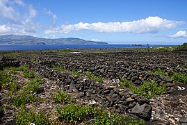
The vine culture on Pico Island began in the late 15th century, when the settlement of the island started. The Verdelho vines found ideal conditions to grow and mature in the volcanic soil and dark stone walls (currais). Later, it was exported to many countries in Europe and the Americas, and even reached the Russian court tables. Years later, wine production is not as important of an economic activity as it used to be, despite trials to improve the varieties and incentives for the restoration of «currais». The vineyards, which mark the island's landscape and ancestral cultural practices, are a UNESCO World Heritage Site since 2004 (see Landscape of the Pico Island Vineyard Culture).[6][29]
Sustainable tourism
In 2012, Pico received the QualityCoast Gold Award for its efforts to become a
Notable people

- Patriarch of the East Indies, 1940–1953.
- Patriarch of the East Indies
- Arquimínio Rodrigues da Costa (1924 in São Mateus – 2016) a prelate of the Catholic Church, Bishop of the Diocese of Macau, 1976–1988.
- Fernando Machado Soares (1930 in São Roque do Pico – 2014) a fado singer, poet, composer, jurist and retired judge.
- Manuel da Silva Rosa (born 1961 in Madalena) a Portuguese American writer about Christopher Columbus
- Caesar DePaço (born 1965 in Madalena) a controversial businessman and former consul for both Portugal and Cape Verde
- Duarte Freitas (born 1966 in São Roque do Pico) a politician and former Member of the European Parliament
Gallery
-
 Black sand beach of Canto da Areia
 -
 Grotões Pond
 -
 Old Dracaena draco near Pico's Wine Museum
 -
.jpg)


See also
- List of volcanoes in Azores
- Pico IPR
- Queijo do Pico
References
Notes
- ^ a b c "Geografia Pico". iaram.azores.gov.pt. Azores Government. Retrieved 11 January 2021.
- ^ a b "INE - Plataforma de divulgação dos Censos 2021 – Resultados Preliminares". censos.ine.pt. Retrieved 8 November 2021.
- ^ "Formação e principais erupções". azoresgreenmark.com. Retrieved 11 January 2021.
- ISBN 978-989-8164-16-2.
- ^ a b c d "Pico Island Discovery and Settlement". iac-azores.org. Retrieved 11 January 2021.
- ^ a b c d e f g h i j k l m n o "Enciclopédia Açoriana". Cultura Açores (in Portuguese). Retrieved 15 June 2021.
- ^ "Vulcão do Pico". ivar.azores.gov.pt. Retrieved 11 January 2021.
- ^ "Sistema Vulcânico Fissural do Pico". ivar.azores.gov.pt. Retrieved 11 January 2021.
- ^ a b c "Pico História". visitazores.com. Retrieved 11 January 2021.
- ^ "Baleeiros açorianos: a história que não se repete". RTP. Retrieved 11 January 2021.
- ^ "Geomorfologia". www.cvarg.azores.gov.pt. Retrieved 7 May 2021.
- ^ "Caracterização e Diagnóstico da Ilha do Pico" (PDF). servicos-sraa.azores.gov.pt. pp. 60–61. Retrieved 7 May 2021.
- ^ "Unidades Vulcanológicas". www.ivar.azores.gov.pt. Retrieved 7 May 2021.
- ^ "Ocupação do Solo | Carta de Ocupação do Solo 2018" (PDF). Ordenamento do Território dos Açores. Retrieved 13 September 2021.
- ^ Frutuoso, Gaspar. "41". Livro Sexto das Saudades da Terra (PDF) (in Portuguese). Ponta Delgada. pp. 131–133. Retrieved 24 December 2021.
- ^ "Natureza" (PDF). azores.gov.pt. Retrieved 14 June 2021.
- ^ a b de Azevedo, Eduardo B. (January 2014). "Climate Overview". Pico Island Natural History Handbook. Observatório Vulcanológico e Geotérmico dos Açores. pp. 16–28. Retrieved 16 June 2021.
- IPMA. Retrieved 24 August 2021.
- ^ a b "Caracterização e Diagnóstico da Ilha do Pico" (PDF). servicos-sraa.azores.gov.pt. Retrieved August 4, 2020.
- ^ "Clima e Diferenciação Climática das Ilhas dos Açores" (PDF). www.climaat.angra.uac.pt. Retrieved August 4, 2020.
- ^ AEMET. Retrieved 6 December 2020.
- IPMA. Retrieved 20 August 2021.
- ^ "Climate: São Roque do Pico". Retrieved 2020-08-04.
- ^ "Horta Climate Normals 1961-1990". National Oceanic and Atmospheric Administration. Retrieved December 18, 2012.
- ^ "Rede Hidrometeorológica dos Açores - Direcção Regional do Ambiente - SRAAC - GRA". portal-sraa.azores.gov.pt. Retrieved 13 January 2022.
- ^ Santos, Carlota; de Matos, Paulo Teodoro. "A demografia das sociedades insulares Portuguesas. Séculos XV a XXI" (PDF). p. 28. Retrieved 14 June 2021.
- ^ Sousa, Ivo. "Evolução da população na ilha do Pico (desde 1849 a 2050)". Cais do Pico. Retrieved 14 June 2021.
- ^ Rocha, Gilberta Pavão Nunes. "A População das Regiões Insulares dos Açores e da Madeira em 2011". Instituto Nacional de Estatística. p. 4. Retrieved 14 June 2021.
- ^ "Vinha da Ilha do Pico, Património da Humanidade". www.visitportugal.com (in European Portuguese). Retrieved 16 June 2021.
- ^ "Sustainable Tourism Destination EUCC" (PDF). Archived from the original (PDF) on 2016-09-18. Retrieved 2013-04-02.
Sources
- Scarth, Alwyn; Tanguy, Jean-Claude (2001), Volcanoes of Europe, ISBN 0-19-521754-3
- Nunes, J.C. (1999), A actividade vulcânica na ilha do Pico do Plistocénio Superior ao Holocénio: Mecanismo eruptivo e hazard vulcânico. Tese de doutoramento no ramo de Geologia, especialidade de Vulcanologia, Ponta Delgada: University of the Azores, p. 357
- Madeira, José Eduardo de Oliveira (1998), Estudos de neotectónica nas ilhas do Faial, Pico e S. Jorge: uma contribuição para o conhecimento geodinâmico da junção tripla dos Açores. Tese de Doutoramento no ramo de Geologia, especialidade em Geodinâmica Interna, Lisbon: Faculty of Sciences, University of Lisbon, p. 428
- Madeira, José Eduardo de Oliveira; António Brum da Silveira (October 2003), Active tectonics and first paleoseismological results in Faial, Pico and S. Jorge islands (Azores, Portugal), 5, vol. 46, Lisbon: Annals of Geophysics, pp. 733–761
- Senos, M.L.; Gaspar, João Luís; Ferreira, Teresa; Cruz, L.; Nunes, J.C.; Pacheco, J. (1998), O terramoto do Faial de 9 de Julho de 1998, Proceedings do 1º Simpósio de Meterologia e Geofísica da AMPG, pp. 61–68
External links
- Pico - A Ilha Montanha Atlantica, a Flickr Group with images of the island
- The Azores Islands Blogspot, with information on the Azores and Pico Island
- A Pico hike and trip report (September 2007)
- Visit Pico
| Grupo Oriental (Eastern Group) |  | |
|---|---|---|
| Grupo Central (Central Group) | ||
| Grupo Ocidental (Western Group) | ||
| Islets | ||
| Caves and geological features | ||
| Reefs, banks and seamounts | ||
| Norte |
|  |
|---|---|---|
| Centro | ||
| Lisbon |
| |
| Alentejo |
| |
| Azores |
| |
| Madeira | ||
| International | |
|---|---|
| National | |