
Pietro Vesconte
Pietro Vesconte | |
|---|---|
.jpg) Image of a cartographer, assumed to be Pietro Vesconte himself, from the 1318 Vesconte atlas (Museo Correr, Venice) | |
| Born | |
| Occupation | Italian cartographer |
Pietro Vesconte (
Although Vesconte was born in Genoa, he produced much of his work in Venice. He was active between 1310 and 1330,[1] producing numerous maps. His nautical charts are among the earliest to map the Mediterranean and Black Sea regions accurately. He also produced progressively more accurate depictions of the coastlines of northern Europe, in particular that of Britain and, to a lesser extent, Ireland.
Pietro Vesconte's 1311 portolan chart of the east Mediterranean is the oldest signed and dated nautical chart that survives from the medieval period.[2] He is also the author of at least four signed multi-sheet atlases (1313, 1318a, 1318b, c. 1321), where the various sheets can be combined into a single nautical chart. There is also an atlas (1321) and a solitary portolan chart (1327) signed by "Perrino Vesconte", assumed to be either Pietro himself or possibly a younger relative member of his family using a diminutive form of 'Pietro'.[1] The image of a mapmaker at work, which appears in a Vesconte atlas of 1318, may depict the chartmaker himself.[3]
Pietro Vesconte brought his experience as a maker of portolans to bear on the
Works by or attributed to Vesconte
The following works have been signed or attributed to Pietro Vesconte.[4]
- 1311 dated & signed portolan chart of the east Mediterranean, held (C.N.1) by the Archivio di Stato in Florence, Italy.
- 1313 dated & signed atlas of six sheets held (DD 687) by the
- 1318 dated & signed atlas of seven sheets held (Port. 28) by Museo Correr in Venice, Italy. (1 calendar, 2. Black Sea, 3. east Medit., 4. central Med., 5. west Med, 6. Spain and north Africa, 7. north Atlantic)
- 1318 dated & signed atlas of ten sheets held (MS 594) by Österreichische Nationalbibliothek in Vienna, Austria. (1.calendar, 2. Black Sea, 3. east Medit., 4. central Medit. (south), 6. central Medit. (north) 7. west Medit., 8. Spain and French Atlantic coast, 9. British Isles, 10. Adriatic Sea)
- c.1320-21 undated but signed by Vesconte, for Marino Sanudo's Liber secretorum, mappa mundi plus atlas of five sheets (partially missing), held (Pal. Lat.1362A) by the Bibliotheca Apostolica in Vatican City (2. Black sea, 3. Aegean, 4. Palestine & east Medit. 5. Adriatic and North Africa, 6. west Medit and north Atlantic)
- 1321 dated and signed Perrino Vesconte, atlas of five sheets held (R.P.4) by the Zurich, Switzerland. (1 calendar, 2. Spain and north Atlantic, 3. central Medit., 4. east Medit. 5. Black Sea)[6]
- c.1321 undated atlas of nine sheets held (MS 175) by the Bibliothèque municipale in Lyons, France. (1. calendar, 2. rhumb network, 3. Black Sea, 4. east Medit., 5. central Medit (north), 6. central Medit (north) 7. west Medit. 8. British Isles & France, 9. Adriatic Sea)
- c.1321 undated and unsigned, confidently attributed to Vesconte, for Marino Sanudo's Liber secretorum, mappa mundi and atlas of five sheets held (Vat. Lat. 2972) by the Bibliotheca Apostolica in Vatican City (1. Black Sea, 2. Aegean and north Africa, 3. Palestine & east Medit. 4. central medit,5. west Medit and north Atlantic)[7]
- c.1325 undated and unsigned, confidently attributed to Vesconte, for Marino Sanudo's Liber secretorum, mappa mundi and atlas of five sheets, held (Add MS 27376) by the British Library, in London, UK. (1. Spain and north Atlantic, 2. central Medit., 3. Palestine & east Medit., 4. Aegean & north Africa, 5. Black Sea)
- 1327 dated and signed Perrino Vesconte, portolan chart, held (Med Palat.248) by the
-
 Pietro Vesconte's 1311 portolan of the eastern Mediterranean, the first signed portolan chart (Archivio di Stato, Florence)
 -
 Astronomical calendar from the 1313 atlas of Pietro Vesconte. (Bibliotheque Nationale de France, Paris)
 -
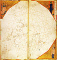
 Atlantic map, sheet from the 1313 atlas of Pietro Vesconte. (Bibliotheque Nationale de France, Paris)
 -
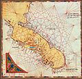 Map of the Adriatic Sea, sheet from the 1318 atlas of Pietro Vesconte (Österreichische Nationalbibliothek, Vienna)
 -
 Atlantic map, sheet from the 1321 atlas of "Perrino" Vesconte (Zentralbibliothek Zurich)
 -
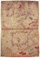
 west Mediterranean map, sheet from Pietro Vesconte c. 1321 atlas (Bibliothèque municipale de Lyon)
 -
 north Atlantic (France, Britain, Ireland) map, sheet from Pietro Vesconte c. 1321 atlas (Bibliothèque municipale de Lyon)
 -
 Atlantic map, sheet from Vesconte's c.1321 atlas for Marino Sanuto's Liber Secretum (Vatican Library)
 -
 Atlantic map, sheet from Vesconte's c.1325 atlas for Marino Sanuto's Liber Secretum (British Library)
 -
 Pietro Vesconte's Mappa Mundi from Marino Sanuto's Liber secretorum (oriented with East at the top)


.jpg)
_atlas.jpg)
_atlas.jpg)


References
- ^ a b c d "Slide #228F Monograph". henry-davis.com. Retrieved 2015-04-03.
- ISBN 9780719066917. Retrieved 2015-04-03.
- ^ ISBN 9780226316338. Retrieved 2015-04-03.
- ^ Information organized by Tony Campbell, "Census of pre-sixteenth-century portolan charts" at maphistory.info, last visited June 16, 2011
- ^ Vesconte's 1313 Atlas can be found online at 1313 Vesconte Atlas at Gallica, BNF
- ^ The signature reads Perinus Vessconte d’Janua fecit istam tabula Anno dni Mccc xxj in Venecia. A copy of the 1321 atlas can be found online at 1321 Perrino Vesconte atlas at Netzwerk von Bibliotheken und Informationsstellen in der Schweiz (NEBIS, Switzerland)
- ^ A digital copy can be found online at the Digital Vatican Library
- ^ The signature reads Perrinus Vessconte fecit istam cartam Anno dhi M ccc xxvii in Veneciis (Cortesão, 1969: p.38)
- Cortesão, Armando (1969) History of Portuguese Cartography", Lisbon: Ultramar.
| International | |
|---|---|
| National | |
| Artists | |
| People | |