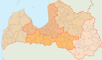
Planning regions of Latvia (before 2021)
(Redirected from
Planning regions of Latvia
)There are five planning regions of Latvia (
new planning regions
in 2021.
They are identical in area to the statistical regions of the country, except with different names and the city of Riga being separate from the rest of Riga Planning Region.
List
| Regions | Largest city | Area | Population - (per km2)[2] |
|---|---|---|---|
Riga |
Riga | 10,132 km2 | 989,525 - (98/km2) |
Kurzeme |
Liepāja | 13,596 km2 | 233,229 - (17/km2) |
Latgale |
Daugavpils | 14,549 km2 | 247,220 - (17/km2) |
| Zemgale | Jelgava | 10,733 km2 | 225,017 - (21/km2) |
Vidzeme |
Valmiera | 15,246 km2 | 180,766 - (12/km2) |
| Latvia | Riga | 64,256 km² | 1,875,757 - (29/km²) |
History
Regional institutions began formation 1997 according to municipal initiatives on the planning of common development. Following legislation on regional development, the five planning regions were created according to the 5 May 2009 decision no. 391 of the Latvian Cabinet of Ministers: "Decisions on Territories of the Planning Regions.[3][4]
See also
- Historical Latvian Lands
- Planning regions of Latvia after 2021 reform
References
- likumi.lv. 2008-12-08. Retrieved 2010-01-10.
- ^ "Population by ethnicity in regions, cities and municipalities at the beginning of year (After administrative-territorial reform in 2021) 2021 - 2022".
- ^ "Plānošanas reģioni" (in Latvian). Ministry of Regional Development and Local-governments. Retrieved 2010-01-10.
- ^ "Noteikumi par plānošanas reģionu teritorijām" (in Latvian). Cabinet of Ministers of Latvia. 2009-05-05. Retrieved 2010-01-10.
External links

