
Podolia
Podolia
Поділля, Podolia Podilia | |
|---|---|
Historical region | |
   
| |
|
UTC+3 (EEST) |
Podolia or Podilia (
Podolia is bordered by the Dniester River and the Eastern Bug River. Covering an area of 40,000 square kilometres (15,000 sq mi), it features an elongated plateau and fertile agricultural land. Its main rivers are the Dniester and the Southern Bug, which serve as important trade channels. Podolia is known for its cherries, mulberries, melons, gourds, and cucumbers.
The region has a rich history, dating back to the Neolithic period, with various tribes and civilizations occupying it over time. It became part of the Kingdom of Galicia–Volhynia, the Golden Horde, the Kingdom of Poland, the Grand Duchy of Lithuania, the Ottoman Empire, the Austrian Habsburg monarchy, and the Russian Empire. In the 20th century, Podolia underwent various political changes, with both Poland and the Soviet Union controlling parts of it at different times.
Podolian culture is renowned for its folk icon-painting tradition, with red, green, and yellow colors dominating the art. Collections of these iconic works can be found in the Vinnytsya Art Museum and the Museum of Ukrainian Home Icons in Radomysl Castle.
Etymology

The name derives from Old Slavic po, meaning "by/next to/along" and dol, "valley" (see dale).[citation needed]
Geography
The area is part of the vast
Podolia lies east of historic
Two large rivers, with numerous tributaries, drain the region: the Dniester, which forms its boundary with Moldova and is navigable throughout its length, and the Southern Bug, which flows almost parallel to the former in a higher, sometimes swampy, valley, interrupted in several places by rapids. The Dniester forms an important channel for trade in the areas of Mohyliv-Podilskyi, Zhvanets, and other Podolian river ports.
In Podolia, 'black earth' (chernozem) soil predominates, making it a very fertile agricultural area. Marshes occur only beside the Bug. A moderate climate predominates, with average temperatures at Kamianets-Podilskyi of 9 °C (−4 °C in January, 20 °C in July).
Russian-ruled Podolia in 1906 had an estimated population of 3,543,700, consisting chiefly of
The chief settlements include Kamianets-Podilskyi, the traditional capital,
.Podolia is known for its
.History
The country has had human inhabitants since at least the beginning of the Neolithic period. Herodotus mentions it as the seat of the Graeco-Scythian Alazones and possibly the Neuri. Subsequently, the Dacians and the Getae arrived. The Romans left traces of their rule in Trajan's Wall, which stretches through the modern districts of Kamianets-Podilskyi, Nova Ushytsia, and Khmelnytskyi.
During the Great
Kingdom of Ruthenia
Prince
Lithuanian, Polish and Ottoman rule
During the 13th century, the

After the death of the Grand Duke of Lithuania Vytautas in 1430, Podolia was incorporated into Podolian Voivodeship of the Kingdom of Poland, with the exception of its eastern part, the Bracław Voivodeship, which remained with Lithuania, both forming part of the Polish–Lithuanian union. With the Union of Lublin of 1569, eastern Podolia passed from Lithuania to Poland with the Polish–Lithuanian Commonwealth. The Kamieniec Podolski Fortress was nicknamed the "gateway to Poland",[1] whereas the city of Kamieniec Podolski itself as one of Poland's major cities enjoyed voting rights during the royal election period.[2] Podolia was invaded several times by the Crimean Tatars and Turks, and during the Deluge, also by Transylvanians and Russians, with notable Polish victories at Udycz (1606), Czarny Ostrów (1657), Uścieczko (1694).
From 1672, Podolia became part of the Ottoman Empire, when and where it was known as Podolia Eyalet. During this time, it was a province, with its center being Kamaniçe, and was divided into the sanjaks of Kamaniçe, Bar, Mejibuji and Yazlovets (Yazlofça).
It returned to Poland in 1699 with the Treaty of Karlowitz.
The region was the site of two notorious massacres, the
In 1768, the Bar Confederation was formed by the Poles, including Casimir Pulaski in Bar in Podolia. Podolia remained part of the Polish–Lithuanian Commonwealth until its Partitions of Poland in 1772 and 1793, when the Austrian and Russian Empires annexed the western and eastern parts respectively.
Russia and Austria

From 1793 to 1917, part of the region was the
In 1772
Several battles of the Polish uprisings of 1809, 1830–1831 and 1863–1864 were fought in Podolia.

As to the Jewish community in Podolia, the
Between Poland and the Soviet Union
With the collapse of Austria-Hungary following
In Poland from 1921 to 1939, western Podolia was part of the
In 1927 there was a massive uprising of peasants and factory workers in Mohyliv-Podilskyi, Kamianets-Podilskyi, Tiraspol and other cities of southern Ukrainian SSR against Soviet authorities. Troops from Moscow were sent to the region and suppressed the unrest, causing around 4000 deaths, according to US correspondents sent to report about the insurrection, which was at the time completely denied by the Kremlin official press.[5]
In 1939 after the signing of the
Starting in July 1941, the Jewish inhabitants were subjected to mass extermination by shooting in a German campaign carried out by four Einsatzgruppen ("operational groups") specially organized for the purpose. Reliable estimates including German, Soviet, and local records indicate that upwards of 1.6 million, perhaps as many as 2 million, Jews were murdered in this fashion. Most were buried in mass graves,[citation needed] but there were also instances of communities being forced en masse into community buildings or synagogues that were then burnt,[citation needed] or herded into local mines that were subsequently dynamited.[citation needed]
In 1944 the Soviets re-occupied Podolia and in 1945, when Poland's eastern border was formally realigned along the
Culture
The Podillia's folk icon-painting tradition is well known in Ukraine. Its manifestation is long home
Notable people
- Jan Potocki (1761-1815), ethnologist, linguist, traveller and author
- Wawrzyniec Dayczak (1882–1968), architect and activist
Gallery
-
 Dominican monastery, Vinnytsia
 -
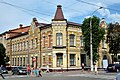 Khmelnytskyi
 -
 The fortress of Kamianets-Podilskyi
 -
 The main building of Uman National University of Horticulture
 -
 Maliivtsi Palace
 -
 Panorama of Rașcov as seen from across the Dniester river
 -
 Emblem
 -
 Kamianets-Podilskyi City Hall
 -

-
 An old street in Kamianets-Podilskyi's old town quarter. Recent restoration works were conducted in the city.
 -
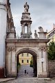 Arch of triumph in Kamianets-Podilskyi


,_%D0%B2%D1%83%D0%BB%D0%B8%D1%86%D1%8F_%D0%86%D0%BD%D1%81%D1%82%D0%B8%D1%82%D1%83%D1%82%D1%81%D1%8C%D0%BA%D0%B0,_4_(%D0%A3%D0%BC%D0%B0%D0%BD%D1%8C).JPG)

.jpg)


References
- ^ Słownik geograficzny Królestwa Polskiego i innych krajów słowiańskich, Tom III (in Polish). Warszawa. 1882. p. 748.
{{cite book}}: CS1 maint: location missing publisher (link) - ^ Polska encyklopedja szlachecka, Tom I (in Polish). Warszawa: Wydawnictwo Instytutu Kultury Historycznej. 1935. p. 42.
- ^ Joachim Bahlcke, Ungarischer Episkopat und österreichische Monarchie: Von einer Partnerschaft zur Konfrontation (1686–1790). 2005.
- ^ a b Bar-Levy, I. A. (1966). Blatman, Leon S. (ed.). 'Kamenetz-Podolsk': A Memorial to a Jewish Community Annihilated by the Nazis in 1941. New York: The Sponsors of the Kamenetz-Podolsk Memorial Book. p. 14 – via Princeton University Press.
- ^ Disorder in the Ukraine?, Time, December 12, 1927
- ^ Богомолець. О. "Замок-музей Радомисль на Шляху Королів Via Regia". — Київ, 2013
- This article incorporates text from a publication now in the public domain: Kropotkin, Peter Alexeivitch; Bealby, John Thomas (1911). "Podolia". In Chisholm, Hugh (ed.). Encyclopædia Britannica. Vol. 21 (11th ed.). Cambridge University Press. p. 875.
- The Road From Letichev, Chapin & Weinstock, Writers' Showcase 2000
External links
- Map of Podolia (1882)
- The Official Site of the Radomysl Castle Archived 2020-08-14 at the Wayback Machine
- (in Russian) Petrov N. (1891) Podolia. A Historical Description (Подолия. Историческое описание) at formats