Pomerape
| Pomerape | |
|---|---|
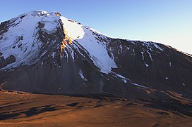
 Pomerape and the saddle below, as seen from south (Parinacota slopes) | |
| Highest point | |
| Elevation | 6,282 m (20,610 ft)[1] |
| Prominence | 950 m (3,120 ft) |
| Isolation | 4 km (2.5 mi) |
| Coordinates | 18°07′33″S 69°07′39″W / 18.12583°S 69.12750°W |
| Geography | |
| Parent range | Andes |
| Geology | |
| Age of rock | Pleistocene |
| Mountain type | Stratovolcano |
| Climbing | |
| Easiest route | snow/ice climb |
Pomerape is a
Parinacota Volcano to the south. The name "Payachata" means "twins" and refers to their appearance.[3] It hosts glaciers down to elevations of 5,300–5,800 metres (17,400–19,000 ft), lower on the northern slope.[4]
Pomerape is a complex of
lava flows which were emplaced atop of the domes.[5] It was active about 200,000 years ago.[6] The lava domes formed first and were later buried by the actual volcanic cone, which unlike the rhyolitic-dacitic domes is formed by hornblende andesite.[7] The "Chungará Andesites" and lava dome complex of Parinacota were laid down at this time.[8] Pomerape is associated with an adventive vent that has erupted mafic magmas. The main cone was last active 106,000 +- 7,000 years ago,[9] the adventive vent is dated to 205,000 ± 24,000 years ago.[10]
Climbing the volcano is
alpine grade PD by the east ridge.[11] Harder routes exist on the south face, sometimes on 50+ degree snow/rubble slope. For these routes a camp can be established at 5,300 metres (17,390 ft) at the saddle between Parinacota and Pomerape. Depending on the season, the main difficulty can be penitentes
(tall ice-blade needles), which make the ascent physically difficult or impossible.
See also
References
- ^ Chilean IGM elevation Archived 2007-09-27 at the Wayback Machine
- ^ Map of Curahuara de Carangas Municipality and population data. Archived 2014-11-11 at the Wayback Machine
- ISBN 9789401074636.
- .
- ISBN 9789562020541.
- ISBN 9783642773556.
- S2CID 129099050.
- doi:10.1130/b25954.1.
- ISSN 0716-0208.
- ISBN 9789562020541.
- ISBN 978-0-9536087-6-8.
- "Parinacota". Global Volcanism Program. Smithsonian Institution. (includes Pomerape)

