
Portal:Guatemala
The Guatemala portal
Republic of Guatemala República de Guatemala (Spanish) | |
|---|---|
Motto:
| |
| Anthem: Himno Nacional de Guatemala (English: "National Anthem of Guatemala") | |
| ISO 3166 code | GT |


Guatemala, officially the Republic of Guatemala, is a country in Central America. It is bordered to the north and west by Mexico, to the northeast by Belize, to the east by Honduras, and to the southeast by El Salvador. It is hydrologically bordered to the south by the Pacific Ocean and to the northeast by the Gulf of Honduras.
The territory of modern Guatemala hosted the core of the Maya civilization, which extended across Mesoamerica; in the 16th century, most of this was conquered by the Spanish and claimed as part of the viceroyalty of New Spain. Guatemala attained independence from Spain and Mexico in 1821. From 1823 to 1841, it was part of the Federal Republic of Central America.
For the latter half of the 19th century, Guatemala suffered instability and civil strife. From the early 20th century, it was ruled by a series of dictators backed by the United States. In 1944, authoritarian leader Jorge Ubico was overthrown by a pro-democratic military coup, initiating a decade-long revolution that led to social and economic reforms. In 1954, a US-backed military coup ended the revolution and installed a dictatorship.
From 1960 to 1996, Guatemala
Guatemala's abundance of biologically significant and unique ecosystems includes many endemic species and contributes to Mesoamerica's designation as a biodiversity hotspot.
Although rich in export goods, around a quarter of the population (4.6 million) face
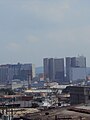
With an estimated population of around 17.6 million,0 Guatemala is the most populous country in Central America, the 4th most populous country in North America and the 11th most populous country in the Americas. Its capital and largest city, Guatemala City, is the most populous city in Central America. (Full article...)
Selected article -

La Blanca is a Maya pre-Columbian Mesoamerican archaeological site in the municipality of Melchor de Mencos in the northern Petén Department of Guatemala. It has an occupation dating predominantly from the Middle Preclassic (900–600 BC) period of Mesoamerican chronology. This site belongs to the later period of the Mokaya culture. The site is located in the lower reaches of the Mopan River valley and features a large acropolis complex. Activity at the site has been dated as far back as the Early Classic (AD 250–600), with principal occupation of the site occurring in the Late Classic period (AD 600–900), although some level of occupation continued into the Early Postclassic (AD 900–1200).
La Blanca occupied a frontier zone between the northeastern and southeastern Petén regions and the site is dominated by the acropolis, an especially well built palace complex. The city appears to have been an administrative centre with comparatively little emphasis upon religious or ceremonial activity. It is likely that La Blanca was a subsidiary of a major Maya city such as Yaxha or Naranjo, given the complete absence of hieroglyphic texts and sculpted monuments, and archaeologists presume that La Blanca served as a frontier post or trading centre. (Full article...)Did you know (auto-generated)

- ... that the Adelaide L. T. Douglas House, built for a New York City socialite, housed the United States Olympic Committee before being sold to Guatemala?
- ... that the Central American government voted for annexation to the First Mexican Empire after a request from Regent Agustín de Iturbide?
Subcategories
WikiProjects

 Good article -
.jpg)
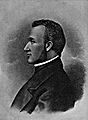
Carlos Castillo Armas (locally ['kaɾlos kas'tiʝo 'aɾmas]; 4 November 1914 – 26 July 1957) was a Guatemalan military officer and politician who was the 28th president of Guatemala, serving from 1954 to 1957 after taking power in a coup d'état. A member of the right-wing National Liberation Movement (MLN) party, his authoritarian government was closely allied with the United States.
Born to a planter, out of wedlock, Castillo Armas was educated at Guatemala's military academy. A protégé of ColonelSelected image -
-

-
 Lake Atitlán, from a dock in San Juan La Laguna
 -
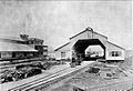 Station and Customs of Puerto Barrios, Guatemala, Northern Railway, 1896
 -
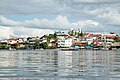 A view ofFlores, El Petén
 -

-
 A view of the beach in Livingston, Guatemala
 -
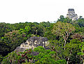 View from the top of the Lost World Pyramid, Temple IV on the right and top of pyramid 5C-49 (also known as the Talud-Tablero Temple) in the Plaza of the Lost World
 -
 A low impact trail built for ecotourists to protect an archeological site in Guatemala
 -
 A camioneta orchicken bus, a typical mode of transportation in Guatemala


_-_Guatemala-1525.jpg)


More did you know -
- Remittancesare the major source of foreign income for Guatemala, accounting for more than the combined value of exports and tourism.
 Featured article -

Quiriguá (Spanish pronunciation: [kiɾiˈɣwa]) is an ancient Maya archaeological site in the department of Izabal in south-eastern Guatemala. It is a medium-sized site covering approximately 3 square kilometres (1.2 sq mi) along the lower Motagua River, with the ceremonial center about 1 km (0.6 mi) from the north bank. During the Maya Classic Period (AD 200–900), Quiriguá was situated at the juncture of several important trade routes. The site was occupied by 200, construction on the acropolis had begun by about 550, and an explosion of grander construction started in the 8th century. All construction had halted by about 850, except for a brief period of reoccupation in the Early Postclassic (c. 900 – c. 1200). Quiriguá shares its architectural and sculptural styles with the nearby Classic Period city of Copán, with whose history it is closely entwined.
Quiriguá's rapid expansion in the 8th century was tied to kingList of Featured articles
|
|---|
-
 Day laborers pay day in Santa Rosa, ca. 1890, according to the Day Laborer Regulations established by Barrios (from History of Guatemala)
 -
 Inauguration of colonel Jacobo Árbenz as president of Guatemala in 1951 (from History of Guatemala)
 -
 Route Map of the Great White Fleet of the United Fruit Company, which had the monopoly of freight and passenger maritime transportante to and from Puerto Barrios in Guatemala since 1903 (from History of Guatemala)
 -
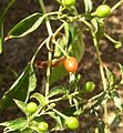 Chiltepe, a common pepper used on some Guatemalan dishes. (from Culture of Guatemala)
 -
 Finance Center in 2011. In 1981, a powerful bomb exploded in the basement of the building, leaving it without windows for several years. The owners -Industrial Bank- decided to keep it open to the public to defy the leftist guerrilla. (from History of Guatemala)
 -
 Manuel Estrada Cabrera ruled Guatemala between 1898 and 1920. (from History of Guatemala)
 -
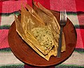 Chipilín Tamal, a common dish usually eaten at dinner. (from Culture of Guatemala)
 -
 General Carrera portrait celebrating the foundation of the Republic of Guatemala in 1847 (from History of Guatemala)
 -
 General Francisco Morazán (from History of Guatemala)
 -
 Coat of Arms of the Republic of Guatemala between 1858 and 1871. A replica was carved on the front side of the Carrera theater before it was remodeled in 1892. (from History of Guatemala)
 -
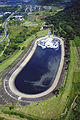 The Jurun Marinalá power plant was conceived during the Arbenz government to compete with the generation of the Electricity Company of Guatemala, which at that time was an American company and was using foreign oil instead of natural resources in Guatemala. Construction was not completed until 1968, fourteen years after Arbenz was removed in a CIA sponsored coup d'état. (from History of Guatemala)
 -
 Criollos rejoice upon learning about the declaration of independence on 15 September 1821. Painting by Rafael Beltranena. (from History of Guatemala)
 -
 State coat of Los Altos, carved in stone on the grave of heroes in the Cemetery of Quetzaltenango (from History of Guatemala)
 -
 1861 map of the boundary between British Honduras (now Belize) and Guatemala (from History of Guatemala)
 -
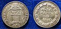 Proclamation Coin 1847 of the independent Republic of Guatemala (from History of Guatemala)
 -
 Captain General Rafael Carrera after being appointed president for life of the Republic of Guatemala in 1854 (from History of Guatemala)
 -
 Barrigones sculpture (from History of Guatemala)
 -
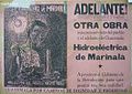 Marinalá power plant advertisement during Arbenz government (from History of Guatemala)
 -
 Guatemala territory during Rafael Carrera andVicente Cerna conservative regimes. Soconusco territories were given to México in exchange for their support to the Liberal revolution in 1871 by Herrera-Mariscal treaty of 1882. (from History of Guatemala)
 -
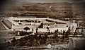 Guatemalan National Penitentiary, built by Barrios to incarcerate and torture his political enemies (from History of Guatemala)
 -
 Plaza Central of Antigua Guatemala in 1829. The old "Palacio de la Capitanía General" was still destroyed after the 1773 earthquake. (from History of Guatemala)
 -
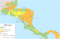 Central America in the 16th century before Spanish conquest (from History of Guatemala)
 -
 Map of railway lines in Guatemala and El Salvador, which were owned by the IRCA, the subsidiary of the United Fruit Company that controlled the railroad in both countries, while the only Atlantic port was controlled by the Great White Fleet, also a UFCO's company (from History of Guatemala)
 -
 Maya city of Tikal (from History of Guatemala)
 -
 Map of Guatemala in 1829. Note that borders with Mexico, Yucatán and Chiapas are not defined. (from History of Guatemala)
 -
 Location of Franja Transversal del Norte -Northern Transversal Strip- in Guatemala (from History of Guatemala)


Topics

Ancestral background of Guatemalan citizens | |
| Guatemalan native groups (Maya and others) | |
| Former and extinct | |
| Guatemalan mestizo |
|
| Descendants of Europeans (white or Criollo) | |
| Descendants of Asians | |
| Afro-descendants | |
| Americas |
|
Featured articles
Good articles
- 5to Piso
- 2010 Guatemala City sinkhole
- Adentro
- Gómez de Alvarado
- El Amor (Ricardo Arjona song)
- Francisco Javier Arana
- Jacobo Árbenz
- Ricardo Arjona
- La Blanca, Peten
- Bartolomé de las Casas
- Central America under Mexican rule
- Como Duele (Ricardo Arjona song)
- El Chal
- Fuiste Tú
- Guatemala at the 2016 Summer Paralympics
- Guatemalan Revolution
- Haʼ Kʼin Xook
- Independiente (Ricardo Arjona album)
- Itzam Kʼan Ahk II
- Iximche
- Kʼinich Yat Ahk II
- Kʼinich Yoʼnal Ahk I
- Manche Chʼol
- Marta (Ricardo Arjona song)
- Mi Novia Se Me Está Poniendo Vieja
- Mixco Viejo
- Motul de San José
- Mundo Perdido, Tikal
- North Acropolis, Tikal
- Poquita Ropa
- Puente (song)
- Quién Dijo Ayer
- Quién (Ricardo Arjona song)
- Quiero (Ricardo Arjona song)
- Battle of Roatán
- Simplemente Lo Mejor
- Spanish American wars of independence
- Spanish conquest of Yucatán
- Spanish conquest of the Maya
- Te Quiero (Ricardo Arjona song)
- Tikal
- Trópico (Ricardo Arjona album)
- Vida (Ricardo Arjona song)
- White-lipped peccary
- Yoʼnal Ahk III
- Zaculeu
Featured pictures
-
 Cinnamon hummingbird (Amazilia rutila) in flight Los Tarrales
 -
 Emerald swift (Sceloporus malachiticus) Finca El Pilar
 -
 Ocellated turkey (Meleagris ocellata) male Peten
_in_flight_Los_Tarrales.jpg)
_Finca_El_Pilar.jpg)
_male_Peten.jpg)
Associated Wikimedia
The following Wikimedia Foundation sister projects provide more on this subject:
-
 Commons
Free media repository -
 Wikibooks
Free textbooks and manuals -
 Wikidata
Free knowledge base -
 Wikinews
Free-content news -
 Wikiquote
Collection of quotations -
 Wikisource
Free-content library -
 Wikiversity
Free learning tools -
 Wikivoyage
Free travel guide -
 Wiktionary
Dictionary and thesaurus
Guatemala news
The current date and time in Guatemala is Wednesday, April 24, 2024, 20:14.
News media:
- The Guatemala Times
- La Prensa Libre (in Spanish)
- Wikinews Guatemala portal


