
Portal:Oceans
– Hover over image and scroll to middle for controls to see more selected panorama images –
-

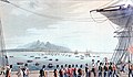
 A panorama of Zanzibar, Tanzania, particularly the Stone Town, taken from the Indian Ocean
 -
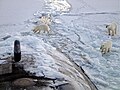
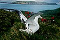
 Orca (Orcinus orca) hunting a Weddell seal in the Southern Ocean
 -
 Princeton-by-the-Sea, northern California
 -
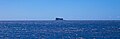
 Satellite view of the Pacific Ocean and the main windward Hawaiian Islands
 -
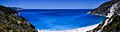 A view of Myrtos Beach and the Ionian Sea, Cephalonia, Ionian Islands, Greece
 -
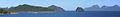
 South Pacific Oceanin Fiji
 -
 Clouds over the Southern Ocean, with continent labels
 -
 A mother sperm whale and her calf in the Indian Ocean off the coast of Mauritius
 -
 A view of the South China Sea, Bacuit Archipelago, municipality of El Nido, Palawan, Philippines
 -
 A view of the Southern Ocean from Great Ocean Road, Port Campbell, Princetown, Victoria, Australia
 -
 Icebergs broken off from glaciers in northern Baffin Bay, Cape York, Greenland
 -
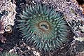 A sea anemone in the Pacific Ocean, Baja California, Mexico
 -
 A view of Filfla and the Mediterranean Sea. Filfla is a small, mostly barren, uninhabited islet 4.5 kilometres (2.8 miles) south of Malta.


Introduction
   |
| Earth's ocean |
|---|
|
Main five oceans division: Further subdivision: Marginal seas |

The ocean is the body of salt water that covers ~70.8% of the Earth. In English, the term ocean also refers to any of the large bodies of water into which the world ocean is conventionally divided. Distinct names are used to identify five different areas of the ocean: Pacific, Atlantic, Indian, Antarctic/Southern, and Arctic. The ocean contains 97% of Earth's water and is the primary component of the Earth's hydrosphere, thus the ocean is essential to life on Earth. The ocean influences climate and weather patterns, the carbon cycle, and the water cycle by acting as a huge heat reservoir. (Full article...)

A sea is a large body of salty water. There are particular seas and the sea. The sea commonly refers to the ocean, the wider body of seawater.
Selected article -

Tides are the rise and fall of sea levels caused by the combined effects of the gravitational forces exerted by the Moon (and to a much lesser extent, the Sun) and are also caused by the Earth and Moon orbiting one another.
Tide tables can be used for any given locale to find the predicted times and amplitude (or "tidal range").
The predictions are influenced by many factors including the alignment of the Sun and Moon, theList of selected articles
|
|---|
Interesting facts -
.jpg)
- The NOAAS Pisces (R 226) oceanographic research vessel (pictured) was named by five seventh graders from Southaven, Mississippi.
- The Top 10 New Species of 2014 included a protist that acts like a sponge.
- In 2018, an asteroid measuring 12 meters (39 feet) across exploded in an air burst over the Bering Sea near the Kamchatka Peninsula with the force of 173 kilotons of TNT.
Selected list articles and Marine habitat topics
| Marine habitats |
|---|
| Coastal habitats |
| Ocean surface |
|
| Open ocean |
| Sea floor |
- List of oceans
- List of ancient oceans
- List of seas
- List of circumnavigations
- List of cruise lines
- List of largest lakes and seas in the Solar System
- List of marine biologists
- List of marine ecoregions
- List of maritime explorers
- List of naval battles
- List of ocean liners
- List of oceanographic institutions and programs
- List of oldest surviving ships
- List of rogue waves
- List of seafood dishes
- List of submarine topographical features
Tasks
 |
Here are some tasks awaiting attention:
|
General images -
-

-
 The island geography of the Pacific Ocean Basin (from Pacific Ocean)
 -
-
 Banks of the northwest Atlantic (from Atlantic Ocean)
 -

-
 Agulhas Bank (from Atlantic Ocean)
 -

-
 The 1564 Typus Orbis Terrarum, a map by Abraham Ortelius, showed the imagined link between the proposed continent of Antarctica and South America. (from Southern Ocean)
 -
 Severe cracks in an ice pier in use for four seasons at McMurdo Station slowed cargo operations in 1983 and proved a safety hazard. (from Southern Ocean)
 -
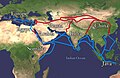 The economically important Silk Road was blocked from Europe by the Ottoman Empire in c. 1453 with the fall of the Byzantine Empire. This spurred exploration, and a new sea route around Africa was found, triggering the Age of Discovery. (from Indian Ocean)
 -
-
 A Chagossian on Diego Garcia in 1971, before the British expelled the islanders. He spoke a French-based creole language and his ancestors were likely brought as slaves in the 19th century. (from Indian Ocean)
 -
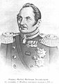 Admiral von Bellingshausen (from Southern Ocean)
 -
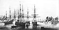
 USS Vincennes at Disappointment Bay, Antarctica in early 1840 (from Southern Ocean)
 -
 Map of the Pacific Ocean during European Exploration, circa 1702–1707 (from Pacific Ocean)
 -
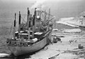
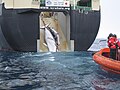 An adult and sub-adult Minke whale are dragged aboard the Japanese whaling vessel Nisshin Maru. (from Southern Ocean)
 -
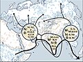
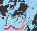
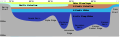 Distribution of the major water mass in the Arctic Ocean. The section sketches the different water masses along a vertical section from Bering Strait over the geographic North Pole to Fram Strait. As the stratification is stable, deeper water masses are denser than the layers above. (from Arctic Ocean)
 -
 Density structure of the upper 1,200 m (3,900 ft) in the Arctic Ocean. Profiles of temperature and salinity for the Amundsen Basin, the Canadian Basin and the Greenland Sea are sketched. (from Arctic Ocean)
 -
 The Antarctic Ocean, as delineated by the draft 4th edition of the International Hydrographic Organization's Limits of Oceans and Seas (2002) (from Southern Ocean)
 -
 The AtlanticPortuguese discoveries and trading port routes, here shown in the India Run ("Carreira da Índia"), which would be developed in subsequent years. (from Atlantic Ocean)
 -
 Tarawa Atoll in Kiribati (from Pacific Ocean)
 -
 An iceberg being pushed out of a shipping lane by (L to R) USS Burton Island, USS Atka, and USS Glacier near McMurdo Station, Antarctica, 1965 (from Southern Ocean)
 -
 Bahama Banks (from Atlantic Ocean)
 -
 The Arctic Ocean, with borders as delineated by the International Hydrographic Organization (IHO), including Hudson Bay (some of which is south of 57°N latitude, off the map) and all other marginal seas. (from Arctic Ocean)
 -
 1911 South Polar Regions exploration map (from Southern Ocean)
 -
 Location of the Southern Ocean gyres (from Southern Ocean)
 -
 Marine debris strewn over the beaches of the South Atlantic Inaccessible Island (from Atlantic Ocean)
 -
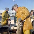 Cod fishery in Norway (from Atlantic Ocean)
 -
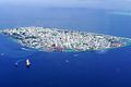 Malé's population has increased from 20,000 people in 1987 to more than 220,000 people in 2020. (from Indian Ocean)
 -
 Coral reefs of the Maldives (from Indian Ocean)
 -
 A general delineation of the Antarctic Convergence, sometimes used by scientists as the demarcation of the Southern Ocean (from Southern Ocean)
 -
 ACascadia Subduction Zone along part of the west coast of North America, whose trench is completely buried in sediments. (from Pacific Ocean)
 -
 Famous official portrait of Captain James Cook who proved that waters encompassed the southern latitudes of the globe. "He holds his own chart of the Southern Ocean on the table and his right hand points to the east coast of Australia on it." (from Southern Ocean)
 -
 Regional Working Group zones for SOOS (from Southern Ocean)
 -
-
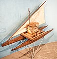 Model of a Fijian drua, an example of an Austronesian vessel with a double-canoe (catamaran) hull and a crab claw sail (from Pacific Ocean)
 -
 Weddell seals (Leptonychotes weddellii) are the most southerly of Antarctic mammals. (from Southern Ocean)
 -
 ASouth Georgia (from Southern Ocean)
 -
 An exclusive economic zone map of the Pacific which excludes non-tropical islands. (from Pacific Ocean)
 -
 Waves in the trade winds in the Atlantic Ocean – areas of converging winds that move along the same track as the prevailing wind – create instabilities in the atmosphere that may lead to the formation of hurricanes.
 -
 During summer, warm continental masses draw moist air from the Indian Ocean hence producing heavy rainfall. The process is reversed during winter, resulting in dry conditions. (from Indian Ocean)
 -
 Map showing the migration of the Austronesian peoples (from Pacific Ocean)
 -
 The bathyscaphe Trieste before her record dive to the bottom of the Mariana Trench, 23 January 1960 (from Pacific Ocean)
 -
 Continents and islands of the Southern Ocean (from Southern Ocean)
 -
 The Andaman Negritos are thought to be the first inhabitants of the Andaman Islands, having emigrated from the mainland tens of thousands of years ago. (from Indian Ocean)
 -
 As the Gulf Stream meanders across the North Atlantic from the North American east coast to Western Europe its temperature drops by 20 °C (36 °F).
 -
 On the sea ice of the Arctic Ocean temporary logistic stations may be installed, Here, aTwin Otter is refueled on the pack ice at 86°N, 76°43‘W. (from Arctic Ocean)
 -
 Iceberg A22A in the South Atlantic Ocean (from Atlantic Ocean)
 -
-
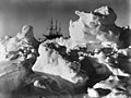 Frank Hurley: As time wore on it became more and more evident that the ship was doomed (Endurance trapped in pack ice), National Library of Australia. (from Southern Ocean)
 -
 In 2020, Japanese Prime Minister Suga declined to drink the bottle of Fukushima's treated radioactive water that he was holding, which would otherwise be discharged to the Pacific. (from Pacific Ocean)
 -
 Typhoon Tip at global peak intensity on 12 October 1979 (from Pacific Ocean)
 -
 cutter Beaufroy (from Southern Ocean)
 -
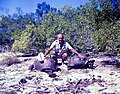
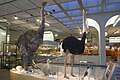 Madagascar's Elephant bird, Mauritius's Dodo bird and ostrich (from left to right) (from Indian Ocean)
 -
 False color map of ocean depth in the Atlantic basin (from Atlantic Ocean)
 -
 Sunset over the Pacific Ocean as seen from the International Space Station. Tops of thunderclouds are also visible. (from Pacific Ocean)
 -
 Emanuel Bowen's 1780s map of the Arctic features a "Northern Ocean". (from Arctic Ocean)
 -
 1937 delineation (from Southern Ocean)
 -
 Based on the medievalGrœnlendinga saga, this interpretative map of the "Norse World" shows that Norse knowledge of the Americas and the Atlantic remained limited. (from Atlantic Ocean)
 -
 The Kennedy Channel. (from Arctic Ocean)
 -
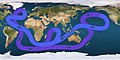 Path of the thermohaline circulation. Purple paths represent deep-water currents, while blue paths represent surface currents.
 -
 Seas that are parts of the Southern Ocean (from Southern Ocean)
 -
 According to the Coastal hypothesis, modern humans spread from Africa along the northern rim of the Indian Ocean. (from Indian Ocean)
 -
 The Arctic region; of note, the region's southerly border on this map is depicted by a red isotherm, with all territory to the north having an average temperature of less than 10 °C (50 °F) in July. (from Arctic Ocean)
 -
 The Antarctic Circumpolar Current (ACC) is the strongest current system in the world oceans, linking the Atlantic, Indian and Pacific basins. (from Southern Ocean)
 -
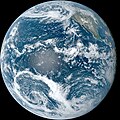 The Pacific Ocean, photograph taken from space by the GOES-18 spacecraft in September 2023 (from Pacific Ocean)
 -
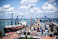 Mombasa Port on Kenya's Indian Ocean coast (from Indian Ocean)
 -
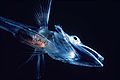
 A femalewarty squid (Moroteuthis ingens) (from Southern Ocean)
 -
 Made in 1529, theDiogo Ribeiro map was the first to show the Pacific at about its proper size (from Pacific Ocean)
 -
 Banks of the northeast Atlantic (from Atlantic Ocean)
 -
 The Arctic region showing the Northeast Passage, the Northern Sea Route within it, and the Northwest Passage. (from Arctic Ocean)
 -
 Thule archaeological site (from Arctic Ocean)
 -
 Maris Pacifici by Ortelius (1589). One of the first printed maps to show the Pacific Ocean (from Pacific Ocean)
 -
 Sunset in Monterey County, California, U.S. (from Pacific Ocean)
 -
 The International Hydrographic Organization's delineation of the "Southern Ocean" has moved steadily southwards since the original 1928 edition of its Limits of Oceans and Seas. (from Southern Ocean)
 -
 Portrait ofEdmund Halley by Godfrey Kneller (before 1721) (from Southern Ocean)
 -
 Excavation of the Ertebølle middens in 1880 (from Atlantic Ocean)
 -
 Impact ofLa Niña on North America (from Pacific Ocean)
 -
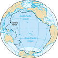 Area inside the black line indicates the area constituting the Pacific Ocean prior to 2002; darker blue areas are its informal current borders following the recreation of the Southern Ocean and the reinclusion of marginal seas. (from Southern Ocean)
 -
 Walruses on Arctic ice floe (from Arctic Ocean)
 -
 Capture of Atlantic northwest cod in million tons (from Atlantic Ocean)
 -
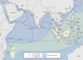
 Major ocean trade routes in the world include the northern Indian Ocean. (from Indian Ocean)
 -
 Minke whale (from Arctic Ocean)
 -
 1928 delineation (from Southern Ocean)
 -
 For most of the 16th century, the Portuguese dominated the Indian Ocean trade. (from Indian Ocean)
 -
 Upwelling in the Southern Ocean(from Southern Ocean)
 -

-
 Pacific Ocean currents have created three islands of debris. (from Pacific Ocean)
 -
 The Austronesian maritime trade network was the first trade routes in the Indian Ocean. (from Indian Ocean)
 -
 In the subpolar gyre of the North Atlantic warm subtropical waters are transformed into colder subpolar and polar waters. In the Labrador Sea this water flows back to the subtropical gyre. (from Atlantic Ocean)
 -
-
 Fish of the Notothenioidei suborder, such as this young icefish, are mostly restricted to the Antarctic and Subantarctic. (from Southern Ocean)
 -
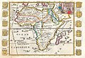
 "Southern Ocean" as alternative to theAethiopian Ocean, 18th century (from Southern Ocean)
 -
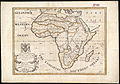
 TheAethiopian Ocean depicted in a 1710 French map of Africa (from Atlantic Ocean)
 -
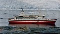 MS Explorer in Antarctica in January 1999. She sank on 23 November 2007 after hitting an iceberg. (from Southern Ocean)
 -
 Map of the Pacific Ocean during European Exploration, circa 1754. (from Pacific Ocean)
 -
 The three major cultural areas of the Pacific Ocean islands: Micronesia, Melanesia and Polynesia (from Pacific Ocean)
 -
 A copepod (from Arctic Ocean)
 -
 Universalis Cosmographia, also known as the Waldseemüller map, dated 1507, was the first map to show the Americas separating two distinct oceans. South America was generally considered the New World and shows the name "America" for the first time, after Amerigo Vespucci (from Pacific Ocean)
 -
 Greco-Roman trade with ancient India according to the Periplus of the Erythraean Sea 1st century CE (from Indian Ocean)
 -
 Embarked and disembarked slaves in the Atlantic slave trade 1525–1863 (first and last slave voyages) (from Atlantic Ocean)
 -
-
 A map of Australia's official interpretation of the names and limits of oceans and seas around Australia (from Southern Ocean)
 -
![Image 104"Terres Australes" [sic] label without any charted landmass (from Southern Ocean)](//upload.wikimedia.org/wikipedia/commons/thumb/8/8e/Geography_world_map.jpeg/120px-Geography_world_map.jpeg) "Terres Australes" [sic] label without any charted landmass (from Southern Ocean)
"Terres Australes" [sic] label without any charted landmass (from Southern Ocean) -
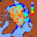 Decrease of old Arctic Sea ice 1982–2007 (from Arctic Ocean)
 -
 Air pollution in South Asia spread over the Bay of Bengal and beyond. (from Indian Ocean)
 -
 Manganese nodule (from Southern Ocean)
 -
 Sea cover in the Arctic Ocean, showing the median, 2005 and 2007 coverage (from Arctic Ocean)


.jpg)


.jpg)


.jpg)

.jpg)
.jpg)


_over_the_Marianas_Trench,_23_January_1960_(NH_96797).jpg)


_peak_intensity.jpg)


.png)


.jpg)


.jpg)


![Image 104"Terres Australes" [sic] label without any charted landmass (from Southern Ocean)](/File:Geography_world_map.jpeg)


Related portals
In the news
- 12 April 2024 – Iran–Israel proxy conflict
- Germany tells its citizens to leave Iran immediately, saying that "air, land and sea transport routes" will likely be affected by military action in the region. (Reuters)
- 8 April 2024 – Russian invasion of Ukraine
- Ukraine claims to have damaged the Russian Navy missile ship Serpukhov in the Baltic Sea near Kaliningrad. (Kyiv Independent)
- 1 April 2024 –
- North Korea fires a ballistic missile into the Sea of Japan near South Korean territory. (AP)
- 31 March 2024 – Visa policy of the Schengen Area
- EU citizens could get easier access to the European Union. (France 24)
- 28 March 2024 – 2023–24 South-West Indian Ocean cyclone season
- Cyclone Gamane makes landfall in Madagascar, killing at least eleven people and causing widespread flooding, according to local officials. (AP)
WikiProjects
Topics

Ocean currents and gyres | |||||||||||
|---|---|---|---|---|---|---|---|---|---|---|---|
| Currents |
| ||||||||||
| Gyres |
| ||||||||||
| Related | |||||||||||
| Present |  | |
|---|---|---|
| Former | ||

Need assistance? Do you have a question about oceans, seas or oceanography that you can't find the answer to? Consider asking it at the Wikipedia reference desk. External media
Discover Wikipedia using portals | |||||||||||||


