
Portal:World
The World Portal


The world is the totality of entities, the whole of reality, or everything that exists. The nature of the world has been conceptualized differently in different fields. Some conceptions see the world as unique while others talk of a "plurality of worlds". Some treat the world as one simple object while others analyze the world as a complex made up of parts.
In scientific cosmology, the world or universe is commonly defined as "[t]he totality of all space and time; all that is, has been, and will be". Theories of modality talk of possible worlds as complete and consistent ways how things could have been. Phenomenology, starting from the horizon of co-given objects present in the periphery of every experience, defines the world as the biggest horizon or the "horizon of all horizons". In philosophy of mind, the world is contrasted with the mind as that which is represented by the mind. Theology conceptualizes the world in relation to God, for example, as God's creation, as identical to God or as the two being interdependent. In religions, there is a tendency to downgrade the material or sensory world in favor of a spiritual world to be sought through religious practice. A comprehensive representation of the world and our place in it, as is found in religions, is known as a worldview. Cosmogony is the field that studies the origin or creation of the world while eschatology refers to the science or doctrine of the last things or of the end of the world.
In various contexts, the term "world" takes a more restricted meaning associated, for example, with the
Selected articles -
-
 Internationalism is a political principle that advocates greater political or economic cooperation among states and nations. It is associated with other political movements and ideologies, but can also reflect a doctrine, belief system, or movement in itself.
Supporters of internationalism are known as internationalists and generally believe that humans should unite across national, political, cultural, racial, or class boundaries to advance their common interests, or that governments should cooperate because their mutual long-term interests are of greater importance than their short-term disputes. (Full article...) -
The2018, replacing the BWF Super Series, which was held from 2007 to 2017.)
The BWF World Tour are divided into six levels, namely World Tour Finals, Super 1000, Super 750, Super 500, and Super 300 in order (part of the HSBC World Tour). One other category of tournament, the BWF Tour Super 100 level, also offers ranking points. (Full article... -
Athe DRC; European megacities are present in Russia, France, the United Kingdom, and Turkey (also in Asia); megacities can be found in Latin America in the countries of Brazil, Mexico, Colombia, Peru, and Argentina. Some sources identify Tokyo's Greater Tokyo Area as the largest megacity in the world, while some others give the title to the Pearl River Delta in China. (Full article...)
-

Earth's history with time-spans of the eons to scale
The history of Earth concerns the development of planet Earth from its formation to the present day. Nearly all branches of natural science have contributed to understanding of the main events of Earth's past, characterized by constant geological change and biological evolution.
The geological time scale (GTS), as defined by international convention, depicts the large spans of time from the beginning of the Earth to the present, and its divisions chronicle some definitive events of Earth history. (In the graphic, Ma means "million years ago".) Earth formed around 4.54 billion years ago, approximately one-third the age of the universe, by accretion from the solar nebula. Volcanic outgassing probably created the primordial atmosphere and then the ocean, but the early atmosphere contained almost no oxygen. Much of the Earth was molten because of frequent collisions with other bodies which led to extreme volcanism. While the Earth was in its earliest stage (Early Earth), a giant impact collision with a planet-sized body named Theia is thought to have formed the Moon. Over time, the Earth cooled, causing the formation of a solid crust, and allowing liquid water on the surface. In June 2023, scientists reported evidence that the planet Earth may have formed in just three million years, much faster than the 10−100 million years thought earlier. (Full article...) -
Alfred Crosby's concept of the Columbian exchange also played a central role in this process. Proto-globalization trade and communications involved a vast group including European, Middle Eastern, Indian, Southeast Asian, and Chinese merchants, particularly in the Indian Ocean region. (Full article...)
-
The rocky side of a mountain creek in Costa Rica
Earth science or geoscience includes all fields of natural science related to the planet Earth. This is a branch of science dealing with the physical, chemical, and biological complex constitutions and synergistic linkages of Earth's four spheres: the biosphere, hydrosphere/cryosphere, atmosphere, and geosphere (or lithosphere). Earth science can be considered to be a branch of planetary science but with a much older history.
There are reductionist and holistic approaches to Earth sciences. It is also the study of Earth and its neighbors in space. Some Earth scientists use their knowledge of the planet to locate and develop energy and mineral resources. Others study the impact of human activity on Earth's environment, and design methods to protect the planet. Some use their knowledge about Earth processes such as volcanoes, earthquakes, and hurricanes to help protect people from these dangerous events. (Full article...) -
General images -
The following are images from various world-related articles on Wikipedia.-
 Satellite time lapse imagery of Earth's rotation showing axis tilt (from Earth)
 -
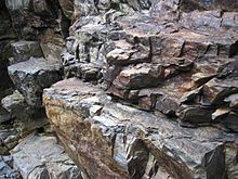
 Geologic map of North America, color-coded by age. From most recent to oldest, age is indicated by yellow, green, blue, and red. The reds and pinks indicate rock from the Archean.
 -

-

-
 Dinosaurs were the dominant terrestrial vertebrates throughout most of the Mesozoic (from History of Earth)
 -
 A reconstruction of Pannotia (550 Ma). (from History of Earth)
 -
 The pale orange dot, an artist's impression of the early Earth which might have appeared orange through its hazy methane rich prebiotic second atmosphere. Earth's atmosphere at this stage was somewhat comparable to today's atmosphere of Titan. (from History of Earth)
 -
 Shanghai. China urbanized rapidly in the 21st century.
 -
 Artist's impression of a Hadean landscape with the relatively newly formed Moon still looming closely over Earth and both bodies sustaining strong volcanism. (from History of Earth)
 -
 Tiktaalik, a fish with limb-like fins and a predecessor of tetrapods. Reconstruction from fossils about 375 million years old. (from History of Earth)
 -

-

-
 An artist's impression of the Archean, the eon after Earth's formation, featuring round stromatolites, which are early oxygen-producing forms of life from billions of years ago. After the Late Heavy Bombardment, Earth's crust had cooled, its water-rich barren surface is marked by continents and volcanoes, with the Moon still orbiting Earth half as far as it is today, appearing 2.8 times larger and producing strong tides. (from Earth)
 -
 A view of Earth with different layers of its atmosphere visible: thestratospheric blue sky at the horizon, and a line of green airglow of the lower thermosphere around an altitude of 100 km, at the edge of space (from Earth)
 -
 View of Earth from the Moon by the Lunar Reconnaissance Orbiter (from Earth)
 -
 Chloroplasts in the cells of a moss (from History of Earth)
 -
 Tracy Caldwell Dyson, a NASA astronaut, observing Earth from the Cupola module at the International Space Station on 11 September 2010 (from Earth)
 -
 Persepolis, Achaemenid Empire, 6th century BCE
 -
 Change in average surface air temperature and drivers for that change. Human activity has caused increased temperatures, with natural forces adding some variability. (from Earth)
 -

-

-
 Artist's conception of Devonian flora (from History of Earth)
 -

-
 A computer-generated image mapping the prevalence ofartificial satellites and space debris around Earth in geosynchronous and low Earth orbit (from Earth)
 -
 A Benin Bronze head from Nigeria
 -
 A view of Earth with itsglobal ocean and cloud cover, which dominate Earth's surface and hydrosphere; at Earth's polar regions, its hydrosphere forms larger areas of ice cover. (from Earth)
 -
 Angkor Wat temple complex, Cambodia, early 12th century
 -
 Empires of the world in 1898
 -
 Last Moon landing: Apollo 17 (1972)
 -
 Great Mosque of Kairouan, Tunisia, founded 670 CE
 -
 "Lucy", the first Australopithecus afarensis skeleton found. Lucy was only 1.06 m (3 ft 6 in) tall.
 -
 Machu Picchu, Inca Empire, Peru
 -
Pale orange dot, an artist's impression of Early Earth, featuring its tinted orange methane-rich early atmosphere (from Earth)
-
 A reconstruction of human history based on fossil data. (from History of Earth)
 -
 An artist's rendering of a protoplanetary disk (from History of Earth)
 -
 A map ofoceanic ridges (from Earth)
 -
 Lithified stromatolites on the shores of Lake Thetis, Western Australia. Archean stromatolites are the first direct fossil traces of life on Earth. (from History of Earth)
 -
 Standing Buddha from Gandhara, 2nd century CE
 -
 Earth's axial tilt causing different angles of seasonal illumination at different orbital positions around the Sun (from Earth)
 -
 A banded iron formation from the 3.15 Ga Moodies Group, Barberton Greenstone Belt, South Africa. Red layers represent the times when oxygen was available; gray layers were formed in anoxic circumstances. (from History of Earth)
 -
 Ajloun Castle, Jordan
 -
 Ming dynasty section, Great Wall of China
 -

-

-
 Yggdrasil, an attempt to reconstruct the Norse world tree which connects the heavens, the world, and the underworld. (from World)
 -
 Vitruvian Man by Leonardo da Vinci epitomizes the advances in art and science seen during the Renaissance. (from History of Earth)
 -
 Obelisk of Axum, Ethiopia
 -
 Earth's land use for human agriculture (from Earth)
 -

-
 Artist's conception ofHadean Eon Earth, when it was much hotter and inhospitable to all forms of life. (from History of Earth)
 -
 A composite image of artificial light emissions at night on a map of Earth (from Earth)
 -
 An artist's impression of ice age Earth at glacial maximum. (from History of Earth)
 -
 The replicator in virtually all known life isdeoxyribonucleic acid. DNA is far more complex than the original replicator and its replication systems are highly elaborate. (from History of Earth)
 -
 A pillar at Göbekli Tepe
 -
 An animation of the changing density ofocean surface (low in purple; high in yellow) (from Earth)
 -
 Earth's history with time-spans of the eons to scale (from History of Earth)
 -
 Cross-section through a liposome (from History of Earth)
 -
 First airplane, the Wright Flyer, flew on 17 December 1903.
 -
 A 580 million year old fossil ofCambrian Explosion. (from History of Earth)
 -
 Olmec colossal head, now at the Museo de Antropología de Xalapa
 -
 Earth's western hemisphere showing topography relative to Earth's center instead of tomean sea level, as in common topographic maps (from Earth)
 -
 A 2012 artistic impression of the early Solar System's protoplanetary disk from which Earth and other Solar System bodies were formed (from Earth)
 -
 A composite image of Earth, with its different types of surface discernible: Earth's surface dominating Ocean (blue), Africa with lush (green) to dry (brown) land and Earth's polar ice in the form of Antarctic sea ice (grey) covering the Antarctic or Southern Ocean and the Antarctic ice sheet (white) covering Antarctica. (from Earth)
 -
 Artist's impression of the enormous collision that probably formed the Moon (from History of Earth)
 -
 The Pantheon, originally a Roman temple, now a Catholic church
 -

-
 Florence, birthplace of the Italian Renaissance
 -

-

-
 Byzantine civilization
 -
 Pangaea was a supercontinent that existed from about 300 to 180 Ma. The outlines of the modern continents and other landmasses are indicated on this map. (from History of Earth)
 -
 Artist's rendition of an oxinated fully-frozen Snowball Earth with no remaining liquid surface water. (from History of Earth)
 -
 Trilobites first appeared during the Cambrian period and were among the most widespread and diverse groups of Paleozoic organisms. (from History of Earth)
 -
 A schematic view of Earth's magnetosphere with solar wind flowing from left to right (from Earth)
 -

-
 Notre-Dame de Paris, France
 -
 Chennakesava Temple, Belur, India
 -
 Graph showing range of estimated partial pressure of atmospheric oxygen through geologic time (from History of Earth)
 -

-

-
 Great Pyramids of Giza, Egypt
 -
 Battle during 1281 Mongol invasion of Japan
 -
 A High Desert storm, sweeps across the Mojave (from Earth)
 -
 Map of peopling of the world (Southern Dispersal paradigm), in thousands of years ago.
 -

-
Artist's impression of Earth during the later Archean, the largely cooled planetary crust and water-rich barren surface, marked by volcanoes and continents, features already round microbialites. The Moon, still orbiting Earth much closer than today and still dominating Earth's sky, produced strong tides. (from History of Earth)
-
 Fall of the Berlin Wall, 1989
 -
 Image of the physical world, captured by the Hubble Space Telescope (from World)
 -
 Taj Mahal, Mughal Empire, India
 -

-
 Earth's night-side upper atmosphere appearing from the bottom as bands of afterglow illuminating the troposphere in orange with silhouettes of clouds, and the stratosphere in white and blue. Next the mesosphere (pink area) extends to the orange and faintly green line of the lowest airglow, at about one hundred kilometers at the edge of space and the lower edge of the thermosphere (invisible). Continuing with green and red bands of aurorae streching over several hundred kilometers. (from Earth)
 -
 Japanese depiction of a Portuguese carrack. European maritime innovations led to proto-globalization.
Megacities of the world -
Tianjin is governed as one of the fourmost populous city proper.Bohai Gulf portion of the Yellow Sea. Part of the Bohai Economic Rim, it is the largest coastal city in Northern China and part of the Jing-Jin-Ji megapolis. (Full article...)Did you know -

- ... that Edward Hopper's 1963 painting Intermission can be viewed as a metaphor for the world as theater?
- ... that German cyclist Antonia Niedermaier won a stage on her first UCI Women's World Tour event, then crashed out of the event the next day?
- ... that the University of the West Indies Seismic Research Centre, which is 70 years old this year, once had an earthquake processing system called "WurstMachine"?
- ... that the plot of Fast and Feel Love involves a character competing to become the fastest cup-stacking competitor in the world?
- ... that the adoption of the Declaration of Independence of Azerbaijan made the Azerbaijan Democratic Republic the first successful republic in the Muslim world?
- ... that the novel Mama Dear by Christine Haidegger details her childhood in post–World War II Austria?
- ... that in developing the Dictionary of Women Worldwide, editors Anne Commire and Deborah Klezmer found other biographical dictionaries often devoted only five percent of their text to women?
- ... that Curtis Imrie won three world championships as a pack burro racer?
Countries of the world -

The Cape Verde archipelago was uninhabited until the 15th century, when Portuguese explorers discovered and colonized the islands, thus establishing the first European settlement in the tropics. Because the Cape Verde islands were conveniently located to play a role in the Atlantic slave trade, Cape Verde became economically prosperous during the 16th and 17th centuries, attracting merchants, privateers, and pirates. It declined economically in the 19th century after the suppression of the Atlantic slave trade, and many of its inhabitants emigrated during that period. However, Cape Verde gradually recovered economically by becoming an important commercial center and useful stopover point along major shipping routes. Cape Verde became independent in 1975. (Full article...)Savage Isles.TheThe National on June 7, 2007, making the official Seven Wonders of Canada, the Canoe, the Igloo, Niagara Falls, Old Quebec City, Pier 21 Halifax, Prairie Skies, and the Rockies. CBC anchor Peter Mansbridge commented on the top winner, “it’s hard to imagine Canada being Canada without the canoe. Explorers, missionaries, fur traders and First Nations—they’re all linked by this subtle and simple craft. To many, the quintessential Canadian experience begins by picking up a paddle. That’s why the canoe is one of the seven wonders” (Osler 2014). There were over 25,000 nominations and 1 million votes cast, according to the CBC website. The top audience votes were the Sleeping Giant, Niagara Falls, the Bay of Fundy, Nahanni National Park Reserve, the Northern Lights, the Rockies, and the Cabot Trail. The CBC website has a dedicated section for the Seven Wonders of Canada (https://www.cbc.ca/sevenwonders/index.html). (Full article...)Related portals
-


.svg)


.jpeg)


.jpg)


.jpg)


.jpg)


Protected areas of the world -
-

Part of the Brecon Beacons National Park, looking from the highest point of Pen y Fan (886 m/2907 feet) to Cribyn (795 m/2608 feet).
Protected areas of the United Kingdom are areas in the United Kingdom which need and /or receive protection because of their environmental, historical or cultural value to the nation. Methods and aims of protection vary depending on the nature and importance of the resource. Protection operates at local, regional, national and international levels, and may be backed by legislation and international treaty, or less formally by planning policy.
Within the United Kingdom, different approaches are taken to some forms of protection within the constituent countries of England, Scotland, Wales and Northern Ireland, while other forms of protection are more consistent across the UK. Protected areas can be divided according to the type of resource which each seeks to protect. Primarily, these are: scenic or landscape value; biodiversity value (species and habitats); geodiversity value (relating to geology and geomorphology); and cultural or historic value. Several types of protected areas are focused on more than one of these areas. (Full article...) -
The Ulyanovsk Oblast in Russia contains about 118 protected natural areas. (Full article...)
-
protected areas. In August 2023, it was estimated a total of 14.5 million hectares or 8.38% of Queensland's landmass was protected. (Full article...)
-
protected areas. Approximately 13.8 percent of Canada's territorial waters are conserved, including 8.9 percent designated as protected areas. Terrestrial areas conserved have increased by 65 percent in the 21st century, while marine areas conserved have increased by more than 3,800 percent.)
Conservation and protected areas have different mandates depending on the organization which manages them, with some areas having a greater focus on ecological integrity, historical preservation, public usage, scientific research, or a combination of usages. Some areas such as the Polar Bear Pass, are co-managed and overseen by government and local indigenous agencies. (Full article... -
Marine Protected Areas comprise over 15.7 million ha representing ca. 5% of territorial waters. (Full article...)
-
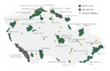
Map of protected areas of the Czech Republic: national parks (grey) and protected landscape areas (green)
There are several types of protected areas of the Czech Republic. The main form of landscape protection is delimitation of special protected areas. All the types of protected areas are determined by law. (Full article...) -
The country ofnational parks and other protected areas. (Full article...)
-
This is a list of the nationally designatedFull article...)
-

In the Philippines, Protected Areas are administered by the Department of Environment and Natural Resources (DENR)'s Biodiversity Management Bureau under the National Integrated Protected Areas System (NIPAS) Act of 1992. As of 2020, there are 244 Protected Areas in the Philippines covering a total area of about 7,760,000 hectares (19,200,000 acres) – 15.4% of the Philippines' total area. (Full article...) -
TheFull article...)
-
-
This is a list ofVitosha Nature Park, established in 1934. All of the nationally protected areas in Bulgaria are also part of the Natura 2000 network of protected natural areas in the territory of the European Union. Bulgaria has some of the largest Natura 2000 areas in the European Union covering 33.8% of its territory.)
- Parks and reserves in italic letters are part of Global 200 ecoregions.
-
National parks of Norway)
About 17 percent of the mainland of Norway is protected. Of this, ca. 8.3 percent is national parks, 1.3 percent is nature reserves and 4.7 percent otherwise protected. (Full article... -
Cadw is the historic environment service of the Welsh Government which manages historical buildings and ancient monuments in Wales. (Full article...)
-

A view of Kaptai National Park
This is a list of protected areas of Bangladesh. Bangladesh is a country in South Asia. It is the eighth-most populous country in the world, with a population exceeding 163 million people in an area of either 148,460 square kilometres (57,320 sq mi) or 147,570 square kilometres (56,980 sq mi), making it one of the most densely populated countries in the world. (Full article...)


Selected world maps
-
 The world map by Gerardus Mercator (1569), the first map in the well-known Mercator projection
 -
 Only a few of the largestlarge igneous provinces appear (coloured dark purple) on this geological map, which depicts crustal geologic provinces as seen in seismic refractiondata
 -
 Index map from the International Map of the World (1:1,000,000 scale)
 -
 The Goode homolosine projection is a pseudocylindrical, equal-area, composite map projection used for world maps.
 -
 Time zones of the world
 -
 1516 map of the world by Martin Waldseemüller
 -
 United Nations Human Development Index map by country (2016)
 -
 A plate tectonics map with volcano locations indicated with red circles
 -
 Mollweide projection of the world


World records
- List of Olympic records in athletics
- List of world records in athletics
- List of junior world records in athletics
- List of world records in masters athletics
- List of world youth bests in athletics
- List of IPC world records in athletics
- List of world records in canoeing
- List of world records in chess
- List of cycling records
- List of world records in track cycling
- List of world records in finswimming
- List of world records in juggling
- List of world records in rowing
- List of world records in speed skating
- List of world records in swimming
- List of IPC world records in swimming
- List of world records in Olympic weightlifting
Topics
Categories

Wikimedia
The following Wikimedia Foundation sister projects provide more on this subject:
-
 Commons
Free media repository -
 Wikibooks
Free textbooks and manuals -
 Wikidata
Free knowledge base -
 Wikinews
Free-content news -
 Wikiquote
Collection of quotations -
 Wikisource
Free-content library -
 Wikispecies
Directory of species -
 Wikiversity
Free learning tools -
 Wikivoyage
Free travel guide -
 Wiktionary
Dictionary and thesaurus


