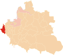
Poznań Voivodeship
Poznań Voivodeship was the name of several former administrative regions (województwo, rendered as
14th century to 1793

Poznań Voivodeship (
1793 to 1921
Between 1793 and 1921, the territory formerly contained in Poznań Voivodeship was part of the following territories: South Prussia, the Poznań Department of the Duchy of Warsaw, the Grand Duchy of Posen, and the Province of Posen in Prussia.
1921 to 1939

After
- Regional capital: Poznań.
- Principal cities: Miedzychód, Ostrów Wielkopolski, Rawicz.
1939 to 1945
During World War II, Poland was occupied by Nazi and Soviet forces and the territory annexed by Germany was named the Reichsgau Wartheland, which partially overlapped with the former Province of Posen and also had Poznań/Posen as its capital.
1945 to 1975
After 1945, the administrative unit centered on Poznań was again known as Poznań Voivodeship. It was superseded by a redrawn Poznań Voivodeship and Kalisz, Konin, Piła and Leszno Voivodeships.
1975 to 1998

The Poznań Voivodeship (Polish: województwo poznańskie) as redrawn in 1975 was again superseded by the Greater Poland Voivodeship, which was formed by the merger of five former Voivodeships.
Capital city: Poznań.
Major cities and towns (with populations in 1995):
- Poznań (581,800);
- Gniezno (71,000);
- Śrem(29,800);
- Września (28,600);
- Swarzędz (26,100);
- Środa Wielkopolska (21,400);
- Luboń (20,700);

