
Precipitation types


In
Precipitation can fall in either liquid or solid phases, is mixed with both, or transition between them at the freezing level. Liquid forms of precipitation include rain and drizzle and dew. Rain or drizzle which freezes on contact with a surface within a subfreezing air mass gains the preceding adjective "freezing", becoming the known freezing rain or freezing drizzle. Slush is a mixture of both liquid and solid precipitation. Frozen forms of precipitation include snow, ice crystals, ice pellets (sleet), hail, and graupel. Their respective intensities are classified either by rate of precipitation, or by visibility restriction.
Phases
Precipitation falls in many forms, or phases. They can be subdivided into:
- Liquid precipitation:
- Drizzle (DZ)
- Rain (RA)
- Cloudburst (CB)
- Freezing/Mixed precipitation:
- Freezing drizzle (FZDZ)
- Freezing rain (FZRA)
- Rain and snow mixed / Slush (RASN)
- Drizzle and snow mixed / Slush (DZSN)
- Frozen precipitation:
- Snow (SN)
- Snow grains (SG)
- Ice crystals (IC)
- Ice pellets / Sleet (PL)
- Snow pellets / Graupel (GS)
- Hail (GR)
- Megacryometeors (MC)
The parenthesized letters are the shortened METAR codes for each phenomenon.[1]
Mechanisms
Precipitation occurs when evapotranspiration takes place and local air becomes saturated with water vapor, and so can no longer maintain the level of water vapor in gaseous form, which creates clouds. This occurs when less dense moist air cools, usually when an air mass rises through the atmosphere to higher and cooler altitudes. However, an air mass can also cool without a change in altitude (e.g. through radiative cooling, or ground contact with cold terrain).
Convective precipitation occurs when air rises vertically through the (temporarily) self-sustaining mechanism of convection. Stratiform precipitation occurs when large air masses rise diagonally as larger-scale winds and atmospheric dynamics force them to move over each other. Orographic precipitation is similar, except the upwards motion is forced when a moving air mass encounters the rising slope of a landform such as a mountain ridge or slope.
Convectional

Convection occurs when the Earth's surface, especially within a conditionally unstable or moist
Graupel and hail indicate convection when either or both are present at the surface. They are indicative that some form of precipitation forms and exists at the freezing level, a varying point in the atmosphere in which the temperature is 0°C.[4] In mid-latitude regions, convective precipitation is often associated with cold fronts where it is often found behind the front, occasionally initiating a squall line.
Cyclonic

Frontal precipitation is the result of frontal systems surrounding
When masses of air with different densities (moisture and temperature characteristics) meet, the less dense warmer air overrides the more dense colder air. The warmer air is forced to rise and, if conditions are right, creates an effect of saturation and condensation, causing precipitation. In turn, precipitation can enhance the temperature and dewpoint contrast along a frontal boundary, creating more precipitation while the front lasts. Passing weather fronts often result in sudden changes in environmental temperature, and in turn the humidity and pressure in the air at ground level as different air masses switch the local weather.
Warm fronts occur where advancing warm air pushes out a previously extant cold air mass. The warm air overrides the cooler air and moves upward. Warm fronts are followed by extended periods of light rain and drizzle due to the fact that, after the warm air rises above the cooler air (which remains on the ground), it gradually cools due to the air's expansion while being lifted, which forms clouds and leads to precipitation.
Cold fronts occur when an advancing mass of cooler air dislodges and plows through a mass of warm air. This type of transition is sharper and faster than warm fronts, since cold air is more dense than warm air and sinks through in gravity's favor. Precipitation duration is often shorter and generally more intense than that which occurs ahead of warm fronts.
A wide variety of weather can be found along an occluded front, usually found near anticyclonic activity, but usually their passage is associated with a drying of the air mass.
Orographic


In
In South America, the
Intensity
Precipitation is measured using a rain gauge, and more recently remote sensing techniques such as a weather radar. When classified according to the rate of precipitation, rain can be divided into categories. Light rain describes rainfall which falls at a rate of between a trace and 2.5 millimetres (0.098 in) per hour. Moderate rain describes rainfall with a precipitation rate of between 2.6 millimetres (0.10 in) and 7.6 millimetres (0.30 in) per hour. Heavy rain describes rainfall with a precipitation rate above 7.6 millimetres (0.30 in) per hour, and violent rain has a rate more than 50 millimetres (2.0 in) per hour.[11]
Snowfall intensity is classified in terms of visibility instead. When the visibility is over 1 kilometre (0.62 mi), snow is determined to be light. Moderate snow describes snowfall with visibility restrictions between .5 kilometres (0.31 mi) and 1 kilometre (0.62 mi). Heavy snowfall describes conditions when visibility is restricted below .5 kilometres (0.31 mi).[12]
Gallery
-
 Tropical downpour in Hong Kong
 -
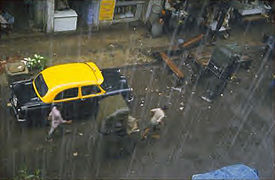 Heavy rain falling inKolkata, India
 -
 Freezing rain in Quebec City, Canada
 -
 Light snow in Portland
 -
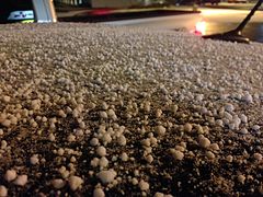 Graupel accumulation in Elko, Nevada
.jpg)


_in_Elko,_Nevada.JPG)
See also
- Weather
- Precipitation
- Flood
- Cyclone
- Low pressure area
References
- ^ "METAR Conversion Card". National Weather Service. Retrieved 2012-12-12.
- ^ B. Geerts. Convective and stratiform rainfall in the tropics. Retrieved on 2007-11-27.
- ISSN 1520-0477.
- ^ Glossary of Meteorology. Graupel. Archived 2008-03-08 at the Wayback Machine Retrieved on 2009-01-02.
- ^ Glossary of Meteorology (2009). "Stratiform precipitation area". American Meteorological Society. Archived from the original on 2011-06-06. Retrieved 2009-07-12.
- ^ Physical Geography. CHAPTER 8: Introduction to the Hydrosphere (e). Cloud Formation Processes. Retrieved on 2009-01-01.
- ^ Diana Leone Rain supreme. Retrieved on 2008-03-19.
- ^ Western Regional Climate Center. Climate of Hawaii. Retrieved on 2008-03-19.
- ^ Paul E. Lydolph. The Climate of the Earth. Retrieved on 2009-01-02.
- ^ Michael A. Mares. Encyclopedia of Deserts. Retrieved on 2009-01-02.
- ^ Glossary of Meteorology (2012). "Rain". American Meteorological Society. Retrieved 2014-11-13.
- ^ Glossary of Meteorology (2009). "Snow". American Meteorological Society. Archived from the original on 2009-02-20. Retrieved 2009-06-28.