Prince Charles Island
Source: Wikipedia, the free encyclopedia.
Uninhabited island in Canada, off the west coast of Baffin Island
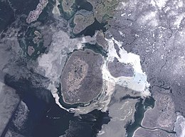
 NASA Landsat image of Prince Charles Island | |
 | |
| Geography | |
|---|---|
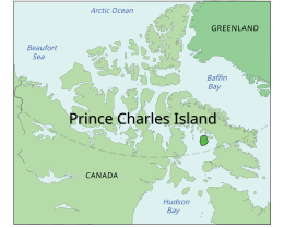
| Location | Foxe Basin |
| Coordinates | 67°47′N 76°12′W / 67.783°N 76.200°W / 67.783; -76.200 (Prince Charles Island)[1] |
| Area | 9,521 km2 (3,676 sq mi) |
| Highest elevation | 73 m (240 ft) |
| Administration | |
Canada | |
| Territory | Nunavut |
| Region | Qikiqtaaluk |
| Demographics | |
| Population | Uninhabited |
Prince Charles Island is a large, low-lying island in Canada. With an area of 9,521 km2 (3,676 sq mi), it is the
Prince Charles (later King Charles III), who was born in November the same year.[citation needed
]

See also
References
- ^ "Prince Charles Island". Geographical Names Data Base. Natural Resources Canada.
- ISBN 9781862393745– via Google Books.
- ISBN 9781136786808– via Google Books.
- ^ a b Hayes, Derek. 'Newestfoundland' (Canadian Geographic, 123 (5), Sep.-Oct. 2003: 34-35).
Further reading
- Morrison, R. I. G. 1997. "The Use of Remote Sensing to Evaluate Shorebird Habitats and Populations on Prince Charles Island, Foxe Basin, Canada". Arctic. 50, no. 1: 55.
| |||||||||||||
|---|---|---|---|---|---|---|---|---|---|---|---|---|---|
| Realms | |||||||||||||
| Titles and honours | |||||||||||||
| Family |
| ||||||||||||
| Life as Prince of Wales | |||||||||||||
| Accession and coronation | |||||||||||||
| Reign | |||||||||||||
| Charities and campaigns |
| ||||||||||||
| Residences |
| ||||||||||||
| Awards given and created | |||||||||||||
| Business ventures | |||||||||||||
| Depictions |
| ||||||||||||
| Eponyms | |||||||||||||
This Qikiqtaaluk Region, Nunavut location article is a stub. You can help Wikipedia by expanding it. |


