
Prospect Hill (New South Wales)
| Prospect Hill | |
|---|---|
 | |
| Highest point | |
| Elevation | 117 m (384 ft) |
| Coordinates | 33°49′1″S 150°55′35″E / 33.81694°S 150.92639°E |
| Dimensions | |
| Length | 3 km (1.9 mi) |
| Naming | |
| Native name | Mar-rong |
| Geography | |
 Prospect Hill Location in Greater metropolitan Sydney | |
| Country | Australia |
| State | New South Wales |
| Region | |
| Type of rock | Igneous rock Intrusive rock Laccolith Shale |
| Official name | Prospect Hill; Bellevue (Hill); Mar-Rong Reserve |
| Type | State heritage (landscape) |
| Designated | 17 October 2003 |
| Reference no. | 1662 |
| Type | Historic Landscape |
| Category | Landscape – Cultural |
Prospect Hill, or Marrong Reserve,
The site is a former industrial building, agricultural farms, quarry, rural housing, research facility and pastoral property and now industrial building, housing, park, public park, brick quarry and pastoral property.
Prospect Hill is a “nodal point” of the Cumberland Plain. Its summit affords a “goodly prospect” west to the Blue Mountains and east to the man-made landmarks of central Sydney. People have walked round and over Prospect Hill for 30,000 years[7] and have recognised it as a landmark, a meeting place and a boundary. It was known to local people as Mar-rong. For today's Australians it has historic significance, aesthetic values and commercial values. There are extensive industrial and housing developments on its slopes. The hill has a number of summits, with the Main Summit, now within Marrong Reserve, being the most popular for visitors.
Oval in shape, the hill has historical significance as one of the first places in the fledgling
History
Indigenous history
The area of Prospect Reservoir is an area of known Aboriginal occupation, with favourable camping locations along the Eastern Creek and Prospect Creek catchments, and in elevated landscapes to the south. There is also evidence to suggest that the occupation of these lands continued after European contact, through discovery of intermingled glass and stone flakes in archaeological surveys of the place. The area was settled by Europeans by 1789.[6]
European discovery

Very early after first settlement, on 26 April 1788, an exploration party heading west led by Governor Phillip, climbed Prospect Hill. An account by Phillip states that the exploration party saw from Prospect Hill, "for the first time since we landed Carmathen [sic] Hills (Blue Mountains) as likewise the hills to the southward". Phillip's "Bellevue" (Prospect Hill) acquired considerable significance for the new settlers. Prospect Hill provided a point from which distances could be meaningfully calculated, and became a major reference point for other early explorers.[9] Statements that Prospect Hill is the hill named Belle-Vue by Governor Phillip on its ascent by his expedition in April 1788 are unsubstantiated in contemporary record.[10]
When Captain-Lieutenant Watkin Tench made another official journey to the west in 1789, he began his journey with reference to Prospect Hill, which commanded a view of the great chain of mountains to the west. A runaway convict, George Bruce, used Prospect Hill as a hideaway from soldiers in the mid-1790s.[6] The first recorded ascent of Prospect Hill by a colonist is that of Tench and his party on 26 June 1789.[11] While there is no documentary evidence of Tench having named Prospect Hill, there is no doubt that it is in fact the hill that was shortly afterwards known by that name. In view of Tench's literary allusions to Milton's Paradise Lost, it seems highly probable that the experience of climbing it reminded him of the "goodly prospect of some forein land first-seen" by Milton's scout and that it was indeed Tench who first named it.[12]
The earliest written reference to the name Prospect Hill is probably the account of an after-dinner walk from Parramatta to the hill by Governor Phillip and Lieutenant (later Governor) Philip Gidley King in April 1790. King's account shows that the name Prospect Hill had become established by then.[13]
During the initial struggling years of European settlement in NSW, Governor Phillip began to settle time-expired convicts on the land as farmers, after the success of James Ruse at Rose Hill.[14] On 18 July 1791 Phillip placed a number of men on the eastern and southern slopes of Prospect Hill, as the soils weathered from the basalt cap were richer than the sandstone derived soils of the Cumberland Plain. The grants, mostly 12 hectares (30 acres), encircled Prospect Hill.[15] The settlers included William Butler, James Castle, Samuel Griffiths, John Herbert, George Lisk, Joseph Morley, John Nichols, William Parish and Edward Pugh.[6][14]
Aboriginal and European conflict
The arrival of the first settlers prompted the first organised Aboriginal resistance to the spread of settlement, with the commencement of a violent frontier conflict in which Pemulwuy and his Bidjigal clan played a central role.[16] This ended in violent attacks in February 1798 in which dozens of settlers were killed. Retaliation by Europeans was generally fast and austere with many aboriginals killed who had not been involved in the attacks on Europeans. Eventually, a reconciliation was started by the Aboriginal people, negotiated by their women and one of the Prospect Hill settlers, John Kennedy. On 1 May 1801 Governor King took drastic action, issuing a public order requiring that Aboriginal people around Parramatta, Prospect Hill and Georges River should be "driven back from the settlers" habitations by firing at them'. King's edicts appear to have encouraged a shoot-on-sight attitude whenever any Aboriginal men, women or children appeared.[16][6]
With the death of Pemulwuy, the main resistance leader, in 1802, Aboriginal resistance gradually diminished near Parramatta, although outer areas were still subject to armed hostilities. Prompted by suggestions to the Reverend
Land use
In 1791 Governor Phillip started granting plots of land (mostly 12 to 28 hectares (30 to 70 acres)) to emancipated convicts. Some convicts had spent years in prison and prison ships in England before being transported. Some of those who were under seven-year sentences had therefore completed them. Thirteen grants of land at Prospect Hill were made in July 1791.[18] In 1799 Ensign William Cummings of the New South Wales Corps was granted 30 hectares (75 acres) at Prospect Hill.[19] From its commencement in 1791 with the early settlement of the area, agricultural use of the land continued at Prospect Hill. Much of the land appears to have been cleared by the 1820s and pastoral use of the land was well established by then. When Governor Macquarie paid a visit to the area in 1810, he was favourably impressed by the comfortable conditions that had been created.[6][20]
A change in the interpretation of government policy in 1792 had opened the way for grants of land to officers of the New South Wales Marine Corps. Cummings was the first beneficiary of this change. In 1808 William Lawson was granted 220 hectares (550 acres) on the western slopes of the west ridge where he was to build his home Veteran Hall. He then bought Cummings' grant and it was here that his third son, Nelson Lawson built a magnificent home, Grey Stanes, on the crown of Prospect Hill.[6][21] Governor Macquarie confirmed the grant, where William Lawson had built a house, which he called "Veteran Hall", because he had a commission in the NSW Veterans Company. The house was demolished in 1928 and the site is now partly covered by the waters of Prospect Reservoir.
Greystanes was approached by a long drive lined with an avenue of English trees -
The land was farmed from 1806 to 1888 when the Prospect Reservoir was built. In 1867, the Governor of New South Wales appointed a Commission to recommend a scheme for Sydney's water supply, and by 1869 it was recommended that construction commence on the Upper Nepean Scheme. This consisted of two diversion weirs, located at Pheasant's Nest and Broughton's Pass, in the Upper Nepean River catchment, with water feeding into a series of tunnels, canals and aqueducts known as the Upper Canal. It was intended that water be fed by gravity from the catchment into a reservoir at Prospect. This scheme was to be Sydney's fourth water supply system, following the Tank Stream, Busby's Bore and the Botany (Lachlan) Swamps.[6] Designed and constructed by the NSW Public Works Department, Prospect Reservoir was built during the 1880s and completed in 1888. Credit for the Upper Nepean Scheme is largely given to Edward Orpen Moriarty, the Engineer in Chief of the Harbours and Rivers Branch of the Public Works Department from 1858 to 1888.[6][24] By the 1870s, with the collapse of the production of cereal grains across the Cumberland Plain, the Prospect Hill area appears to have largely been devoted to livestock. The dwellings of the earliest settlers largely appear to have been removed by this stage. By the time that any mapping was undertaken in this vicinity, most of these structures had disappeared, making their locations difficult to pinpoint.[14][6]
Modern history

Quarrying of the basalt plug at Prospect Hill was well underway by the mid-nineteenth century.
In 1998 Boral reviewed its holdings with a view to future redevelopment as its quarry neared the end of its life. SEPP59 was gazetted in 1999 applying to a number of
As at 19 February 2001, The southern portion of Prospect Hill, located within the Boral Brickworks site has been extensively quarried; however the CSIRO site has largely retained its original surface form. Archaeological potential high within the CSIRO site.[6] Long-term pastoral use on much of Prospect Hill has ensured the site retains its historical links and archaeological potential. However, Prospect Hill is under immediate threat from development, which has the potential to impact upon the significance of the site. This includes the rezoning of the site as part of SEPP 59 and development for residential/employment purposes, the continual quarrying of the southern portion of the hill; and new development proposals including a proposed flagpole to be erected on Prospect Hill commemorating Federation.[6] Various modifications, extensions and refurbishment of buildings within CSIRO research complex over time.[6] In 2002 Delfin Lend Lease entered a joint venture with Boral to develop the residential lands. This part of the estate is now known as Nelson's Ridge (after Nelson Lawson who owned the Greystanes Estate and commissioned Greystanes House in 1837). Nelson's Ridge is being developed by Lend Lease in two stages with the first comprising the northern employment and northern residential lands and the second comprising the southern equivalents.[6]
The former CSIRO site to the north of Nelson's Ridge was vacated in 1/2002 and sold to Stockland in March 2002. SEPP 59 also rezoned it for residential and employment uses. This site has its own precinct plan, now adopted into the Holroyd City Council's Development Control Plan: Part P Pemulwuy Residential Lands. It will eventually be integrated with the Nelson's Ridge development through Driftway Drive as well as cycleways and pedestrian links being established between the two.[26][6]

The land inside the oval-shaped ridge was
On 31 December 2019, during the intense 2019–20 Australian bushfire season, a grass fire broke out on the hill's pine forest and the contiguous grey box reserve, where it headed north towards Pemulwuy along the Prospect Highway. About 10 hectare size and burning a number of historic Monterey pine trees, the fire impacted a large industrial area and threatened numerous properties before being brought under control by about 9 pm that day.[28]
As of 2021, Boral have begun excavation and preparation of a significant area at the base of the hill for an extension of the housing development of Pemulwuy. The development will sit between the Canal Walkway and the pine forest.
Geography

Rain that falls on the southern slopes of Prospect Hill flows into Prospect Creek and then via the Georges River into Botany Bay. The northern slopes drain into Girraween Creek and eventually into the Parramatta River and Port Jackson (Sydney Harbour). Close by to the west is Prospect Reservoir and beyond it, Eastern Creek flows north-west into the Nepean-Hawkesbury River, the mighty river that encircles Sydney forming the boundary of the Cumberland Plain and eventually flowing into the sea at Broken Bay.
Lying centrally in the Cumberland Plain and dominating the landscape of the area, Prospect Hill is Sydney's largest body of igneous rock and rises to a height of 117 metres above sea level.[15] The hill is located between the south-west corner of CSIRO Division of Animal Production site and the south-east corner of the Boral Resources (NSW) site at Greystanes. The CSIRO portion of Prospect Hill is generally cleared for pasture grasses, with remnant stands of native vegetation along a creek line that runs from north to south along the site. The portion of Prospect Hill located within the Boral site has remnant stands of trees and has been partially used as part of the Boral Brickworks operation.[6]
The first settlement of the area occurred in 1791 on the eastern and southern slopes of Prospect Hill, however no buildings dating from the 18th or 19th century remain above ground.[14] A number of the original boundaries of the Prospect land grants of 1791 can be identified when looking east across the CSIRO site from Prospect Hill.[15] On the slope of Prospect Hill, north of the hilltop, is an abandoned quarry dating to the later part of the 19th century.[6][15]
Geology

In the Sydney Basin, insignificant igneous activity took place in the Early Jurassic (i.e. 210 million years ago), Late Mesozoic (i.e. 100-90 million years ago) and Cenozoic eras (i.e. 65 million years ago). The Early Jurassic activity resulted in the shaping of the Prospect dolerite intrusion, which unequivocally points that the hill had a volcanic origin. When Australia, then part of the Gondwana supercontinent, began to break up and drift away from Antarctica and Zealandia 80 million years ago, this may have also caused a period of volcanic activity along the east coast, as breakup tension caused deep faults in the continental crust allowing magma to ascent from the mantle regions below the earth's surface.[29]
The eroded residue of the volcanic core forms Prospect Hill, which was battered down over millions of years to a small bulge in the generally flat lands of western Sydney.
Summits
Prospect Hill is a narrow ridge curved round in the shape of an incomplete oval, about one kilometre from west to east and 2 kilometres (1.2 mi) from north to south. The most accurate description of the shape of the ridge is to say that it is J-shaped, with the upright of the J pointing a few degrees east of north. The summits are described in order starting from the top of the "J" and proceeding clockwise round the ridge.
.jpg)
- Prospect Hill: The northerly summit and the main summit, which is a free-standing Reconciliation Day, in addition to it being the site of focus for school excursions.[36]
- Marrong Reserve North: Situated just south of Butu Wargun Drive, it is now the highest point of Prospect Hill having an elevation of 117 metres (384 feet). The summit area contains a recreational scrub to Daruga Avenue in Pemulwuy. To the west there is the restituted face of Prospect Quarry, which can be viewed by visitors. Before quarrying, the hill was 122 metres (400 feet) high and the then highest point was the site of a trig point named Greystanes by the NSW Department of Lands. A larger area stretching southwards is also designated as Marrong Reserve. To note, this hill is colloquially known as Pemulwuy Lookout.[38]
- Marrong Reserve 'Saddle Bund': Features a long walking track that leads to the adjoining summit above and as well as a lookout area that overlooks the industrial zone and Prospect Quarry in the west.[36]

- One-Tree Hill: This hill has a prominent Moreton Bay figtree, dated to be over 150 years old, which was within the precincts of Grey Stanes, the house of Nelson Lawson. Although inaccessible to the public, the hill can be viewed from Prospect Highway south of the M4 or from Daruga Avenue, Pemulwuy.
- Marrong Reserve South: The summit ridge is fairly level but with steep sides. Its highest point is 100 metres (328 feet) above sea level. The western part of the
Heritage listing
As at 19 February 2001, the Prospect Hill area had state significance due to its unique combination of significant landscape feature, potential archaeological site, and association with important historical phases. As a dolerite outcrop rising to a height of 117 metres (384 ft) AHD , Prospect Hill is a rare geological and significant topographic feature providing expansive views across the Cumberland Plain.[15][6]
The site is significant as a major reference point for early explorers from 1788, and as the site of a number of the earliest farms in New South Wales, which were established in 1791.[14] Prospect Hill is also associated with Aboriginal frontier warfare during the early days of the colony, and as the site of one of the first Aboriginal/ European reconciliation meetings held in 1805 involving Samuel Marsden and Prospect Aboriginal groups.[16][6]
Through its ongoing pastoral and rural use, the site has the potential to provide archaeological evidence of early farming practice and settlement.[14] The landscape of Prospect Hill is likely to be one of the only remaining areas of rural land within the local and regional area that has retained its long-term pastoral use since the earliest days of the colony.[6]
Criteria
Prospect Hill was listed on the New South Wales State Heritage Register on 17 October 2003 having satisfied the following criteria.[6]
The place is important in demonstrating the course, or pattern, of cultural or natural history in New South Wales.
Prospect Hill is historically significant as the site of a number of the earliest farms in New South Wales, with a number of time-expired convicts settled on the land in 1791 by Governor Phillip.[14] As a significant landmark on the Cumberland Plain, Prospect Hill provided an important reference point for early explorers from 1788, and played a role in the earliest exploration of the east coast of Australia.[15] Prospect Hill is also associated with an important phase of Aboriginal/European contact; firstly through Pemulwuy's guerilla warfare in the area between 1797 and 1802, and in 1805 as the site of a reconciliation meeting involving Samuel Marsden.[16][6]
Prospect Hill has historical associations arising from the use of the site over time; including the Aboriginal frontier leader Pemulwuy, Samuel Marsden and those earliest former convicts who settled at Prospect Hill including William Butler, Samuel Griffiths and William Parish.[6]
The place is important in demonstrating aesthetic characteristics and/or a high degree of creative or technical achievement in New South Wales.
Prospect Hill has aesthetic significance as Sydney's largest body of igneous rock, which rises to a height of 117 metres and provides expansive views across the Cumberland Plain. The large dolerite formation of Prospect Hill is a rare geological and landmark topographic feature, lying centrally within the Cumberland Plain.[15] Through the long-term use of the site for pastoral use, the landscape retains an essentially rural character, which is becoming rare in the locality.[6]
The place has strong or special association with a particular community or cultural group in New South Wales for social, cultural or spiritual reasons.
Through its continued use for research purposes over the last 40 years, the CSIRO complex, which is located at the foot of Prospect Hill, has significance for those employees who have worked at the research facility, and in particular for those scientists who have carried out work which is of importance to Australia';s cultural history.[42][6]
The place has potential to yield information that will contribute to an understanding of the cultural or natural history of New South Wales.
Through its continual pastoral/rural use since 1791, Prospect Hill has the potential to provide archaeological evidence of early historical settlement or agricultural techniques used.[6][14]
The place possesses uncommon, rare or endangered aspects of the cultural or natural history of New South Wales.
Prospect Hill is unique as a significant landmark site, and through its ability to demonstrate historical links with early European exploration and settlement as well as Aboriginal conflict and reconciliation, with the landscape retaining its continual pastoral use since the early days of the colony.[6]
Gallery
-
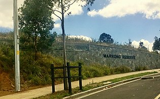 Entrance to Marrong Reserve (north)
 -
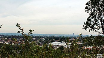 Lookout from the northern summit at Marrong Reserve, with a view of Parramatta, Chatswood and the Hills District (2017).
 -
 A walking and cycling track in Marrong Reserve South, which meanders around the southern summit (2018)
 -
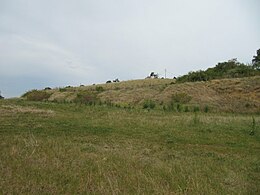
 Marrong Reserve South, as viewed from a neighbourhood in Smithfield (2007)
 -
 View of Prospect Hill, the northernmost summit (2019)
 -


.jpg)

See also
- Prospect, a suburb nearby
- Prospect Nature Reserve, a hill west of this summit
- Prospect Reservoir, a nearby reservoir
- Lower Prospect Canal Reserve
- Geography of Sydney
References
- ^ a b Yeo, Melissa (2017). "Marrong Reserve fenced off to residents over public liability stoush". The Daily Telegraph. Retrieved 22 November 2023.
- ^ Collins, D., Phillip, A. and Hunter, J., Vocabulary of the language of N S Wales in the neighbourhood of Sydney, MS 41645c in School of Oriental and African Studies library, London, c1788-1791.
- ^ NSW Government Architect's Office, Prospect Hill Heritage Landscape Study and Plan, NSW Department of Commerce, 2008, p 31.
- ^ Map by Wilshire in: Wallace, I. Prospect and Richmond: Engineering and environmental geology, Sydney, 1976.
- ^ Dawes, W. "The Aboriginal Language of Sydney" (Notebook). pp. 50–51.
- ^ .
- ^ Macey, Richard (2007). "Settlers' history rewritten: go back 30,000 years". The Sydney Morning Herald. Retrieved 5 July 2014.
- ^ Wilshire, H.G. (1967) The Prospect Alkaline Diabase-Picrite Intrusion New South Wales, Australia. Journal of Petrology 8(1) pp.97-163.
- ^ a b Karskens, Grace (1991). Holroyd - A social history of Western Sydney.
- ^ White, J. (1790). Journal of a Voyage to New South Wales. London: J. Debrett.
- ^ Tench, W. (1793). A Complete Account of the Settlement at Port Jackson in New South Wales. London: G. Nicol and J. Sewell.
- ^ Milton. J. (1667). Paradise Lost. Vol. II. p. 917.
- ^ King, P. G. (1793). Hunter, J. (ed.). An Historical Journal of the Transactions at Port Jackson and Norfolk Island. London: Stockdale.
- ^ a b c d e f g h i Higginbotham, Edward (2000). Historical and Archaeological Assessment of CSIRO site.
- ^ a b c d e f g Ashton, W. (2000). Landscape Heritage Assessment: CSIRO Division of Animal Production.
- ^ a b c d e f g Flynn, M., Holroyd History and the Silent Boundary Project, Holroyd City Council, August 1997.
- ^ Sydney Gazette, 5 May 1805
- ^ Historical Records of New South Wales, Vol 1 Part 2: Phillip 1783–1792, Sydney, 1892, pp 532 ff.
- ^ Ryan, R. J., Land grants 1788–1809, Sydney, 1981.
- ^ Pollen, Francis (1996). Greystanes - in 'The Book of Sydney Suburbs'.
- ^ Australian Dictionary of Biography, 2006, Vol. 2, pp 96–97.
- ^ Pollon, 1988, 116, amended Read, S.,2006 - the house can't have been "on the crest" of Prospect Hill as Pollon states, if its site was covered by the Reservoir.
- ^ Darwin, C. Compton, Keith (ed.). "Notes on the Geology of places visited during the Voyage". Mindat: Prospect, New South Wales. p. 814.
- ^ B Cubed Sustainability. 2005. p. 7.
- ^ Perumal Murphy Wu, 2000
- ^ Whelans InSites, 2010, 5
- ^ Holroyd 2007: Holroyd Development Control Plan 2007, (Part G: Former CSIRO Site Pemulwuy Residential Lands – Western Precinct), Holroyd City Council, 2007.
- ^ "NSW bushfires: Greystanes blaze brought under control". The Daily Telegraph. 31 December 2019. Archived from the original on 31 December 2019. Retrieved 31 December 2019.
- ^ Johnson R. W. (1989). Volcano distribution and classification. In: Johnson R. W., Knutson J. And Taylor S. R. eds. Intraplate Volcanism: In Eastern Australia and New Zealand, pp. 7 11. Cambridge University Press, Cambridge, UK.
- ISBN 978-0-521-38083-6.
- ^ Jones, I., and Verdel, C. (2015). Basalt distribution and volume estimates of Cenozoic volcanism in the Bowen Basin region of eastern Australia: Implications for a waning mantle plume. Australian Journal of Earth Sciences, 62(2), 255-263.
- ^ Wilshire: Wilshire, H.G., The Prospect alkaline diabase-picrite intrusion, New South Wales, Australia in Journal of Petrology, Vol. 8 (1), pp 97-163, 1967.
- ^ Conybeare Morrison, Prospect Hill Conservation Management Plan, Holroyd City Council, 2005
- ^ Jones, I., Verdel, C., Crossingham, T., and Vasconcelos, P. (2017). Animated reconstructions of the Late Cretaceous to Cenozoic northward migration of Australia, and implications for the generation of east Australian mafic magmatism. Geosphere, 13(2), 460-481.
- ^ England, B. M. (1994) Minerals of the Prospect Intrusion, New South Wales, Australia. Mineralogical Record 25, pp.185-194.
- ^ a b Prospect Hill Plan of Management Cumberland Council, March 2019. Retrieved 22 November 2023.
- ^ Look out! Snakes about! by Cumberland City Council. Retrieved November 21 2023.
- ^ Prospect 9030-2N, Topographic map 1:25 000, Third Edition, Land and Property Information NSW, 2001.
- ^ Horne, R. & Robinson, G.L. 1988. Development of basal area thinning prescription and predictive yield models for Pinus radiata plantations in New South Wales, 1962–1968. Research Paper No. 6. Sydney, Forestry Commission of New South Wales.
- ^ Holroyd 2009: Betteridge, C. and M., Heritage Interpretation Plan for Prospect Hill, Holroyd City Council, 2009.
- ^ Map "based on topography by Cumberland Co Council 1964" in Wilshire, H.G., The Prospect alkaline diabase-picrite intrusion, New South Wales, Australia in Journal of Petrology, Vol. 8 (1), 1967
- ^ Perumal Murphy Wu 2000
Bibliography
- It's over the Hill. 3 December 2003.
{{cite book}}:|work=ignored (help) - Ashton, W. (2000). Landscape Heritage Assessment: CSIRO Division of Animal Production.
- Morrison, Conybeare (2005). Prospect Hill Conservation Management Plan.
- Environmental Resources Management Australia (2002). Greystanes Estate - Residential Lands Precinct Plan.
- Flynn, M. (1997). Holroyd History and the Silent Boundary Project.
- Government Architect's Office (2008). Prospect Hill - Heritage Landscape Study & Plan - Final Report.
- Graham Brooks & Associates (2007). Heritage Impact Statement - State Heritage Register Precinct within the Lakewood Residential Estate, Pemulwuy.
- Higginbotham, Edward (2000). Historical and Archaeological Assessment of CSIRO site.
- Jo McDonald Cultural Heritage Management (2004). Archaeological Salvage Excavations in the Greystanes Estate.
- Karskens, Grace (1991). Holroyd - A social history of Western Sydney.
- Lend Lease (2015). Statement of Heritage Impact - Marrong Reserve South, Greystanes Estate, Pemulwuy (Nelsons Ridge Residential Lands).
- Perumal Murphy Wu (2000). Architectural Assessment- CSIRO Division of Animal Production.
- Pollen, Francis (1996). Greystanes - in 'The Book of Sydney Suburbs'.
- Sturt Noble Associates and Lend Lease, Issue for Public Exhibition, 17 November 2015 (2015). Draft Plan of Management – Marrong Reserve, Pemulwuy.
{{cite book}}: CS1 maint: multiple names: authors list (link) CS1 maint: numeric names: authors list (link) - Whelans InSites (2010). Statement of Environmental Effects - Mar-Rong Reserve, Pemulwuy - Construction of Landscaping and Public Domain Works, Greystanes Esttate, Nelsons Ridge.
Attribution
![]() This Wikipedia article was originally based on Prospect Hill, entry number 01662 in the New South Wales State Heritage Register published by the State of New South Wales (Department of Planning and Environment) 2018 under CC-BY 4.0 licence, accessed on 2 June 2018.
This Wikipedia article was originally based on Prospect Hill, entry number 01662 in the New South Wales State Heritage Register published by the State of New South Wales (Department of Planning and Environment) 2018 under CC-BY 4.0 licence, accessed on 2 June 2018.