
Provinces of Japan

Provinces of Japan (令制国, Ryōseikoku) were first-level administrative divisions of Japan from the 600s to 1868.
Provinces were established in Japan in the late 7th century under the
The Provinces of Japan were replaced with the current
History

The provinces were originally established by the
Edo period
In the Edo period, the fiefs became known as han. Imperial provinces and shogunal domains made up complementary systems. For example, when the shōgun ordered a daimyō to make a census or to make maps, the work was organized in terms of the boundaries of the provincial kuni.[2]
Meiji period
At the
Provinces are classified into
Today

No order has ever been issued explicitly abolishing the provinces, but they are considered obsolete. Nevertheless, their names are still widely used in names of natural features, company names, and brands. These province names are considered to be mainly of historical interest. They are also used for the names of items, including
Some of the province names are used to indicate distinct parts of the current prefectures along with their cultural and geographical characteristics. In many cases these names are also in use with directional characters, e.g. Hoku-Setsu (北摂) meaning Northern (北) Settsu (摂津) area.
The
The following list is based on the
Goki (五畿, Five Provinces in Capital Region)

| Kinai | ||
| Tōkaidō | Tōsandō | Hokurikudō |
| San'indō | San'yōdō | Nankaidō |
| Saikaidō |
Kinai (畿内, Capital Region)
- Yamashiro (Jōshū, Sanshū, Yōshū) (山城国 (城州, 山州, 雍州))
- Yamato (Washū) (大和国 (和州))
- Kawachi (Kashū) (河内国 (河州))
- Izumi (Senshū) (和泉国 (泉州)) - Created in 716 from Kawachi Province as Izumi Gen (和泉監). Although occupied by Kawachi Province in 740, in 757 the province divided again from Kawachi Province.
- Settsu (Sesshū) (摂津国 (摂州))
Shichidō (七道, Seven Circuits)
Tōkaidō (東海道, East Sea Circuit)
- Iga (Ishū) (伊賀国 (伊州)) – separated from Ise Province in 680
- Ise (Seishū) (伊勢国 (勢州))
- Shima (Shishū) (志摩国 (志州)) – separated from Ise Province at the beginning of the 8th century
- Owari (Bishū) (尾張国 (尾州))
- Mikawa (Sanshū) (三河国 (三州))
- Tōtōmi (Enshū) (遠江国 (遠州))
- Suruga (Sunshū) (駿河国 (駿州))
- Izu (Zushū) (伊豆国 (豆州)) – separated from Suruga Province in 680
- Kai (Kōshū) (甲斐国 (甲州))
- Sagami (Sōshū) (相模国 (相州))
- Musashi (Bushū) (武蔵国 (武州)) – Transferred from Tōsandō to Tōkaidō in 771
- Awa (Bōshū, Anshū) (安房国 (房州, 安州)) – Divided from Kazusa Province in 718. Although re-joined to Kazusa Province in 741, separated from Kazusa Province again in 781
- Kazusa (Sōshū) (上総国 (総州)) – divided from Fusa Province (総国) in the 7th century
- Shimōsa (Sōshū) (下総国 (総州)) – divided from Fusa Province in the 7th century
- Hitachi (Jōshū) (常陸国 (常州))
Tōsandō (東山道, East Mountain Circuit)
- Ōmi (Gōshū) (近江国 (江州))
- Mino (Nōshū) (美濃国 (濃州))
- Hida (Hishū) (飛騨国 (飛州))
- Shinano (Shinshū) (信濃国 (信州))
- Kōzuke (Jōshū) (上野国 (上州)) – divided from Keno Province (毛野国) during the 4th century
- Shimotsuke (Yashū) (下野国 (野州)) – divided from Keno Province during the 4th century
- Dewa (Ushū) (出羽国 (羽州)) – broke Dewa District in Echigo Province and create Dewa Province in 712. On October of the same year, Mogami and Okitama Districts in Mutsu Province merged into Dewa Province.
- Mutsu (Ōshū, Rikushū) (陸奥国 (奥州, 陸州)) – split off from Hitachi Province in the 7th century
Hokurikudō (北陸道, North Land Circuit)
- Wakasa (Jakushū) (若狭国 (若州))
- Echizen (Esshū) (越前国 (越州)) – broke off from Koshi Province (越国) during the end of the 7th century
- Kaga (Kashū) (加賀国 (加州)) – divided from Echizen Province in 823
- Noto (Nōshū) (能登国 (能州)) – divided from Echizen Province in 718. Although occupied by Etchu Province in 741, divided from Etchū Province in 757
- Etchū (Esshū) (越中国 (越州)) – broke off from Koshi Province during the end of the 7th century
- Echigo (Esshū) (越後国 (越州)) – broke off from Koshi Province during the end of the 7th century
- Sado (Sashū, Toshū) (佐渡国 (佐州, 渡州)) – although occupied by Echigo in 743, divided from Echigo in 752
San'indō (山陰道, Mountain's Shady Side Circuit)
- Tanba (Tanshū) (丹波国 (丹州))
- Tango (Tanshū) (丹後国 (丹州)) – divided from Tanba in 713
- Tajima (Tanshū) (但馬国 (但州))
- Inaba (Inshū) (因幡国 (因州))
- Hōki (Hakushū) (伯耆国 (伯州))
- Izumo (Unshū) (出雲国 (雲州))
- Iwami (Sekishū) (石見国 (石州))
- Oki (Onshū, Inshū) (隠岐国 (隠州))
San'yōdō (山陽道, Mountain's Sunny Side Circuit)
- Harima (Banshū) (播磨国 (播州))
- Mimasaka (Sakushū) (美作国 (作州)) – divided from Bizen Province in 713
- Bizen (Bishū) (備前国 (備州)) – broke off from Kibi (吉備国) during the 2nd half of the 7th century
- Bitchū (Bishū) (備中国 (備州)) – broke off from Kibi Province during the 2nd half of the 7th century
- Bingo (Bishū) (備後国 (備州)) – broke off from Kibi Province during the 2nd half of the 7th century
- Aki (Geishū) (安芸国 (芸州))
- Suō (Bōshū) (周防国 (防州))
- Nagato (Chōshū) (長門国 (長州))
Nankaidō (南海道, South Sea Circuit)
Equivalent to Shikoku and its surroundings, as well as a nearby area of Honshu
- Kii (Kishū) (紀伊国 (紀州))
- Awaji (Tanshū) (淡路国 (淡州))
- Awa (Ashū) (阿波国 (阿州))
- Sanuki (Sanshū) (讃岐国 (讃州))
- Iyo (Yoshū) (伊予国 (予州))
- Tosa (Doshū) (土佐国 (土州))
Saikaidō (西海道, West Sea Circuit)
Equivalent to Kyushu and its surroundings
- Buzen (Hōshū) (豊前国 (豊州)) – broke off from Toyo Province (豊国) at the end of the 7th century
- Bungo (Hōshū) (豊後国 (豊州)) – broke off from Toyo Province at the end of the 7th century
- Chikuzen (Chikushū) (筑前国 (筑州)) – broke off from Tsukushi Province (筑紫国) until the end of the 7th century
- Chikugo (Chikushū) (筑後国 (筑州)) – broke off from Tsukushi Province until the end of the 7th century
- Hizen (Hishū) (肥前国 (肥州)) – broke off from Hi Province (火国) until the end of the 7th century
- Higo (Hishū) (肥後国 (肥州)) – broke off from Hi Province until the end of the 7th century
- Hyūga (Nisshū, Kōshū) (日向国 (日州, 向州)) – earlier called Kumaso Province (熊曾国)
- Ōsumi (Gūshū) (大隅国 (隅州)) – divided from Hyūga Province in 713
- Satsuma (Sasshū) (薩摩国 (薩州)) – divided from Hyūga Province in 702
- Iki (Isshū) (壱岐国 (壱州)) – officially Iki no Shima (壱岐嶋)
- Tsushima (Taishū) (対馬国 (対州)) – officially Tsushima no Shima (対馬嶋)
Hachidō (八道, Eight Circuits)
Hokkaidō (北海道, North Sea Circuit)
Equivalent to
- Oshima (渡島国)
- Shiribeshi (後志国)
- Iburi (胆振国)
- Ishikari (石狩国)
- Teshio (天塩国)
- Kitami (北見国)
- Hidaka (日高国)
- Tokachi (十勝国)
- Kushiro (釧路国)
- Nemuro (根室国)
- Chishima (千島国) - After the Treaty of Saint Petersburg (1875), Japan added north of Urup Island and placed Uruppu (得撫郡), Shimushiru (新知郡), and Shumushu (占守郡) Districts.
Gallery
-
 Borders of the provinces from the Kamakura period until 1868.
 -
 Map of Japan at the end of the Edo period published in the United States in 1855.
 -
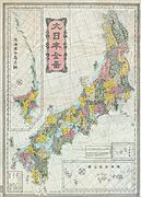 Meiji period map of Japan's provinces from ca. 1880s, after their replacement with the prefectures.


See also
- Code of Taihō
- Magiri
- Kokushi (officials)
- Demographics of Japan before Meiji Restoration
- Ritsuryō
- Han (administrative division)
- Samurai
Notes
- ^ Mass, Jeffrey P. and William B. Hauser. (1987). The Bakufu in Japanese History, p. 150.
- ^ Roberts, Luke S. (2002). Mercantilism in a Japanese Domain: the merchant origins of economic nationalism in 18th-century Tosa, p. 6; excerpt, "Imperial provinces "remained on the cultural map as commonly used definers of territorial regions called kuni ... because when the shogun ordered populations registers and maps to be made, he had them organized along the borders of the provincial kuni. This has been interpreted as important evidence of the shogun's styled role as a servant of the emperor, one of the important means by which he legitimized his authority."
References
External links
Detailed maps of the provinces at different times can be found at: