
Prowers County, Colorado
Prowers County | |
|---|---|
UTC−6 (MDT) | |
| Congressional district | 4th |
| Website | www |
Prowers County is a
Geography
According to the
Adjacent counties
- Kiowa County (north)
- Greeley County, Kansas (northeast)
- Hamilton County, Kansas (east)
- Stanton County, Kansas (southeast/Central Time border)
- Baca County (south)
- Bent County (west)
Major highways
- U.S. Highway 50
- U.S. Highway 287
- U.S. Highway 385
- U.S. Highway 400
 State Highway 89
 State Highway 196
Trails and byways
- American Discovery Trail
- Santa Fe Trail National Scenic Byway
Antipode
Prowers County is home of the
Demographics
| Census | Pop. | Note | %± |
|---|---|---|---|
| 1890 | 1,969 | — | |
| 1900 | 3,766 | 91.3% | |
| 1910 | 9,520 | 152.8% | |
| 1920 | 13,845 | 45.4% | |
| 1930 | 14,762 | 6.6% | |
| 1940 | 12,304 | −16.7% | |
| 1950 | 14,836 | 20.6% | |
| 1960 | 13,296 | −10.4% | |
| 1970 | 13,258 | −0.3% | |
| 1980 | 13,070 | −1.4% | |
| 1990 | 13,347 | 2.1% | |
| 2000 | 14,483 | 8.5% | |
| 2010 | 12,551 | −13.3% | |
| 2020 | 11,999 | −4.4% | |
| 2023 (est.) | 11,751 | [6] | −2.1% |
| U.S. Decennial Census[7] 1790-1960[8] 1900-1990[9] 1990-2000[10] 2010-2020[1] | |||
At the
The age distribution was 27.1% under the age of 18, 9.3% from 18 to 24, 22.7% from 25 to 44, 26.3% from 45 to 64, and 14.6% 65 or older. The median age was 36.7 years. For every 100 females there were 97.7 males. For every 100 females age 18 and over, there were 93.1 males.
The median household income was $33,969 and the median family income was $47,052. Males working full-time and year-round had a median income of $32,359 versus $28,727 for females. The per capita income for the county was $18,429. About 18.7% of families and 22.1% of the population were below the
Politics
Like all of the High Plains, Prowers County is majority Republican. It has not been carried by a Democratic presidential nominee since Jimmy Carter in 1976.
| Year | Republican | Democratic | Third party | |||
|---|---|---|---|---|---|---|
| No. | % | No. | % | No. | % | |
| 2020 | 4,008 | 72.07% | 1,458 | 26.22% | 95 | 1.71% |
| 2016 | 3,531 | 70.39% | 1,186 | 23.64% | 299 | 5.96% |
| 2012 | 3,230 | 66.42% | 1,519 | 31.24% | 114 | 2.34% |
| 2008 | 3,043 | 65.94% | 1,487 | 32.22% | 85 | 1.84% |
| 2004 | 3,392 | 71.49% | 1,308 | 27.57% | 45 | 0.95% |
| 2000 | 3,026 | 66.89% | 1,361 | 30.08% | 137 | 3.03% |
| 1996 | 2,504 | 53.83% | 1,745 | 37.51% | 403 | 8.66% |
| 1992 | 2,371 | 44.10% | 1,770 | 32.92% | 1,236 | 22.99% |
| 1988 | 2,978 | 56.34% | 2,207 | 41.75% | 101 | 1.91% |
| 1984 | 3,501 | 68.71% | 1,467 | 28.79% | 127 | 2.49% |
| 1980 | 3,115 | 59.77% | 1,669 | 32.02% | 428 | 8.21% |
| 1976 | 2,578 | 46.13% | 2,861 | 51.20% | 149 | 2.67% |
| 1972 | 3,272 | 61.58% | 1,860 | 35.01% | 181 | 3.41% |
| 1968 | 2,741 | 49.07% | 2,329 | 41.69% | 516 | 9.24% |
| 1964 | 2,044 | 35.11% | 3,759 | 64.57% | 19 | 0.33% |
| 1960 | 3,567 | 59.15% | 2,457 | 40.75% | 6 | 0.10% |
| 1956 | 3,350 | 57.61% | 2,460 | 42.30% | 5 | 0.09% |
| 1952 | 3,978 | 65.13% | 2,087 | 34.17% | 43 | 0.70% |
| 1948 | 2,505 | 49.63% | 2,497 | 49.47% | 45 | 0.89% |
| 1944 | 2,796 | 58.71% | 1,948 | 40.91% | 18 | 0.38% |
| 1940 | 3,115 | 56.87% | 2,309 | 42.16% | 53 | 0.97% |
| 1936 | 2,432 | 43.91% | 2,896 | 52.28% | 211 | 3.81% |
| 1932 | 2,568 | 44.85% | 3,020 | 52.74% | 138 | 2.41% |
| 1928 | 3,228 | 71.50% | 1,216 | 26.93% | 71 | 1.57% |
| 1924 | 2,564 | 59.21% | 1,042 | 24.06% | 724 | 16.72% |
| 1920 | 2,650 | 65.00% | 1,247 | 30.59% | 180 | 4.42% |
| 1916 | 1,683 | 40.48% | 2,168 | 52.14% | 307 | 7.38% |
| 1912 | 928 | 29.05% | 1,042 | 32.62% | 1,224 | 38.32% |
Education
Prowers County is served by four public school districts:
- Granada School District No. RE-1
- Lamar School District No. RE-2
- Holly School District No. RE-3
- Wiley School District
The county is also the home of Lamar Community College, which serves roughly 700 students annually.
Health care
Prowers Medical Center in Lamar, a critical access hospital with 25 beds and a level IV trauma center, serves the county.[13]
Communities
City
Towns
Unincorporated Community
Historic sites
- Granada Relocation Center National Historic District
- Santa Fe National Historic Trail
- Amache National Historic Site
- Lamar station
Gallery
-
 FormerAtchison, Topeka, and Santa Ferailroad locomotive on display in Lamar
 -

-
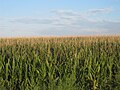 Cornfields flourish after a heavy rain in Prowers County, August 1, 2010
 -
 Area affected by 1930s Dust Bowl


.svg)
See also
- Bibliography of Colorado
- Geography of Colorado
- History of Colorado
- Index of Colorado-related articles
- List of Colorado-related lists
- Outline of Colorado
References
- ^ a b "State & County QuickFacts". United States Census Bureau. Retrieved September 5, 2021.
- ^ "Find a County". National Association of Counties. Retrieved June 7, 2011.
- ^ "US Gazetteer files: 2010, 2000, and 1990". United States Census Bureau. February 12, 2011. Retrieved April 23, 2011.
- ^ "Antipodes Map (AKA Tunnel Map)". www.findlatitudeandlongitude.com.
- ^ "United States Antipodes". www.weathergraphics.com.
- ^ "Annual Estimates of the Resident Population for Counties: April 1, 2020 to July 1, 2023". United States Census Bureau. Retrieved March 31, 2024.
- ^ "U.S. Decennial Census". United States Census Bureau. Retrieved June 10, 2014.
- ^ "Historical Census Browser". University of Virginia Library. Retrieved June 10, 2014.
- ^ "Population of Counties by Decennial Census: 1900 to 1990". United States Census Bureau. Retrieved June 10, 2014.
- ^ "Census 2000 PHC-T-4. Ranking Tables for Counties: 1990 and 2000" (PDF). United States Census Bureau. Archived (PDF) from the original on March 27, 2010. Retrieved June 10, 2014.
- ^ "U.S. Census website". United States Census Bureau. Retrieved February 28, 2018.
- ^ Leip, David. "Dave Leip's Atlas of U.S. Presidential Elections". uselectionatlas.org. Retrieved May 26, 2017.
- ^ "Prowers Medical Center". American Hospital Directory. February 2, 2024. Retrieved March 17, 2024.
Notes
External links
- Prowers County Government website
- Colorado County Evolution by Don Stanwyck
- Colorado Historical Society
Places adjacent to Prowers County, Colorado | ||||||||||||||||
|---|---|---|---|---|---|---|---|---|---|---|---|---|---|---|---|---|
| ||||||||||||||||
Municipalities and communities of Prowers County, Colorado, United States | ||
|---|---|---|
| City |  | |
| Towns | ||
| Unincorporated communities | ||
| Former communities | ||
| ||
37°58′N 102°24′W / 37.96°N 102.40°W
| International | |
|---|---|
| National | |