
Puerto Madryn
You can help expand this article with text translated from the corresponding article in Spanish. (February 2011) Click [show] for important translation instructions.
|
Puerto Madryn
Porth Madryn | ||
|---|---|---|
 | ||
|
Dialing code +54 2804 | | |
| Climate | BWk | |
| Website | www | |
Puerto Madryn (Spanish pronunciation:
Puerto Madryn is protected by the
A new shopping mall in the city centre has helped tourism develop significantly, making Puerto Madryn a more attractive place for both international and domestic tourists visiting
A basketball team,
El Tehuelche Airport is located 10 km (6 miles) northwest of the city centre. Commercial flights from Buenos Aires, Ushuaia, and other Argentinian cities are available. Most tourists fly into Trelew Airport as flights into Puerto Madryn are restricted as a result of environmental concerns.
Geography
Puerto Madryn is situated in Chubut on the Golfo Nuevo, which is formed by the Valdés Peninsula and Punta Ninfas. Puerto Madryn features a cold desert climate (Köppen BWk), with an annual precipitation of between 150 and 200 mm (6" to 8").
| Climate data for Puerto Madryn (extremes 1901–1950, 1982–present)[a] | |||||||||||||
|---|---|---|---|---|---|---|---|---|---|---|---|---|---|
| Month | Jan | Feb | Mar | Apr | May | Jun | Jul | Aug | Sep | Oct | Nov | Dec | Year |
| Record high °C (°F) | 43.4 (110.1) |
40.5 (104.9) |
37.9 (100.2) |
34.9 (94.8) |
28.5 (83.3) |
25.4 (77.7) |
24.5 (76.1) |
29.0 (84.2) |
30.2 (86.4) |
35.0 (95.0) |
38.0 (100.4) |
39.0 (102.2) |
43.4 (110.1) |
| Mean daily maximum °C (°F) | 27.4 (81.3) |
26.9 (80.4) |
24.4 (75.9) |
20.8 (69.4) |
16.1 (61.0) |
12.9 (55.2) |
12.8 (55.0) |
14.5 (58.1) |
17.0 (62.6) |
19.9 (67.8) |
23.7 (74.7) |
26.2 (79.2) |
20.2 (68.4) |
| Daily mean °C (°F) | 19.9 (67.8) |
19.4 (66.9) |
17.3 (63.1) |
14.2 (57.6) |
10.4 (50.7) |
7.8 (46.0) |
7.3 (45.1) |
8.5 (47.3) |
10.5 (50.9) |
13.1 (55.6) |
16.0 (60.8) |
18.3 (64.9) |
13.6 (56.5) |
| Mean daily minimum °C (°F) | 13.7 (56.7) |
13.2 (55.8) |
11.1 (52.0) |
8.1 (46.6) |
5.1 (41.2) |
3.0 (37.4) |
2.1 (35.8) |
2.7 (36.9) |
4.5 (40.1) |
6.9 (44.4) |
9.7 (49.5) |
12.0 (53.6) |
7.7 (45.9) |
| Record low °C (°F) | 3.7 (38.7) |
1.7 (35.1) |
−2.6 (27.3) |
−4.8 (23.4) |
−8.6 (16.5) |
−9.9 (14.2) |
−11.6 (11.1) |
−10.0 (14.0) |
−8.0 (17.6) |
−5.9 (21.4) |
−2.0 (28.4) |
−0.6 (30.9) |
−11.6 (11.1) |
| Average precipitation mm (inches) | 10.0 (0.39) |
14.1 (0.56) |
16.6 (0.65) |
12.6 (0.50) |
23.8 (0.94) |
14.1 (0.56) |
16.6 (0.65) |
10.6 (0.42) |
14.1 (0.56) |
17.8 (0.70) |
10.1 (0.40) |
12.4 (0.49) |
172.8 (6.80) |
| Average relative humidity (%)
|
49 | 53 | 54 | 56 | 63 | 66 | 63 | 59 | 58 | 59 | 51 | 48 | 57 |
| Mean monthly sunshine hours | 289 | 251 | 234 | 170 | 137 | 118 | 134 | 149 | 194 | 234 | 255 | 273 | 2,438 |
| Percent possible sunshine | 62 | 65 | 61 | 52 | 45 | 43 | 46 | 47 | 55 | 57 | 58 | 58 | 54 |
| Source 1: Secretaria de Mineria,[3] Oficina de Riesgo Agropecuario (extremes 1990–present)[4] Centro Nacional Patagónico (extremes 1982–2001)[5] | |||||||||||||
| Source 2: FAO (sun only)[6]
| |||||||||||||
History
The town was founded on 28 July 1865, when 150
The settlement grew as a result of the building of the
Puerto Madryn was the port to which Argentine
Twin towns
 Puerto Montt, Chile[10]
 Paola, Italy[10]
 Nefyn, Wales, United Kingdom[10]
 Pisco, Peru[10]
 Ciudad del Carmen, Mexico[10]
Gallery
-
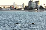 View of Puerto Madryn from the bay with a southern right whale.
 -
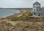 Puerto Madryn coast.
 -
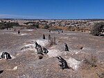 Penguin population near the coast.
 -
 Flag of Argentina in Puerto Madryn.
 -
 Flag flown to recognise the original Welsh settlement of the area


.JPG)

See also
- Immigration in Argentina
- Hospital A R Isola
Notes
- ^ The record highs and lows are based on the Secretaria de Mineria link for the period 1901–1950 while records beyond 1982 come from the Oficina de Riesgo Agropecuario link which covers from 1990–present and data from Centro Nacional Patagónico which covers 1982–2001.
References
- ^ https://www.indec.gob.ar/ftp/cuadros/poblacion/censo2022_indicadores_demograficos.pdf
- ^ Madryn, Discover; trip, Plan your; Seasons; city, Guide of the; subscribe, To; Contact. "Puerto Madryn". madryn.travel. Retrieved 29 January 2022.
- ^ "Provincia de Chubut – Clima Y Meteorologia: Datos Meteorologicos Y Pluviometicos" (in Spanish). Secretaria de Mineria de la Nacion (Argentina). April 2013. Archived from the original on 19 January 2015.
- ^ "Puerto Madryn, Chubut". Estadísticas meteorológicas decadiales (in Spanish). Oficina de Riesgo Agropecuario. Retrieved 29 November 2015.
- ^ "El Clima de la Ciudad de Puerto Madryn" (in Spanish). Centro Nacional Patagónico. Archived from the original on 8 December 2015. Retrieved 29 November 2015.
- ^ "Cuadro 13: Sumas Mensuales y Anuales de las Horas de Sol Efectivas y Porcentaje de los Totales de Horas de Sol" (PDF). Estudio Sobre la Rehabilitacion de Tierras en el Valle de Biedma: Informed Final–Volumen II (in Spanish). Food and Agriculture Organization. p. 97. Retrieved 13 July 2015.
- ^ "The History of the Welsh settlement of Patagonia, Argentina". Historic UK.
- ISBN 0-7083-0579-2.
- ^ "Britain and Argentina agree on return of most P.O.W.'s". The New York Times.
- ^ a b c d e Ciudades y Provincias argentinas hermanadas con contrapartes extranjeras, en Asuntos Federales y Electorales de la Secretaría de Relaciones Exteriores de Argentina
External links
- Project-Hiraeth – Documents the stories of the Welsh colony in Patagonia, Argentina through film, text and illustration.
- Municipal information: Municipal Affairs Federal Institute (IFAM), Municipal Affairs Secretariat, Ministry of Interior, Argentina. (in Spanish)
- Official website
| International | |
|---|---|
| National | |
| Geographic | |