
Puerto del Rosario
This article needs additional citations for verification. (April 2013) |
Puerto del Rosario | |
|---|---|
Municipality | |
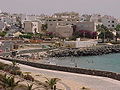
 The town at morning light | |
|
+34 (Spain) + 928 (Las Palmas) | |
| Website | www |
Puerto del Rosario (Spanish pronunciation:
History
Originally known as Puerto de Cabras (Port of the Goats), Puerto del Rosario was initially of little political importance on the island, living in the shadow of the ancient capital Betancuria. It had long been a fishing settlement and benefited from a sheltered natural harbour. The "Atlantic Navigator", written in 1854, describes the town then known as "Cabras" as "the main port", but goes on to describe it as an "insignificant place". The "Atlantic Navigator" describes the makeshift landing area for shipping as "indifferent", while calling the "beach of shingles" where ships anchor as "even worse".[3] It was this status as the "central port" of the island that saw it become the capital of the island in 1860, taking that honour from Antigua. The port was popular for shipping goats and this is where its original name came from. However, in 1957, it was decided that the name "Cabras" was not suitable. A more attractive name was selected and Puerto de Cabras was renamed Puerto del Rosario ("rosary port").
During the 1960s there was rural and urban migration from the smaller villages and farm areas of the island into Puerto del Rosario. The population grew in these years. Further population growth occurred in 1976 when, due to the decolonisation of the North African territories like the Spanish Sahara, the Spanish Foreign Legion made Puerto del Rosario their base.
Climate
Under the
| Climate data for Fuerteventura Airport 25m (1981-2010) | |||||||||||||
|---|---|---|---|---|---|---|---|---|---|---|---|---|---|
| Month | Jan | Feb | Mar | Apr | May | Jun | Jul | Aug | Sep | Oct | Nov | Dec | Year |
| Record high °C (°F) | 28.5 (83.3) |
30.8 (87.4) |
34.0 (93.2) |
38.0 (100.4) |
36.8 (98.2) |
41.6 (106.9) |
43.0 (109.4) |
41.0 (105.8) |
37.9 (100.2) |
36.5 (97.7) |
34.8 (94.6) |
29.5 (85.1) |
43.0 (109.4) |
| Mean daily maximum °C (°F) | 20.6 (69.1) |
21.0 (69.8) |
22.2 (72.0) |
22.9 (73.2) |
24.1 (75.4) |
25.8 (78.4) |
27.3 (81.1) |
27.8 (82.0) |
27.5 (81.5) |
26.1 (79.0) |
24.0 (75.2) |
22.0 (71.6) |
24.3 (75.7) |
| Daily mean °C (°F) | 17.6 (63.7) |
17.9 (64.2) |
18.9 (66.0) |
19.5 (67.1) |
20.6 (69.1) |
22.5 (72.5) |
24.0 (75.2) |
24.6 (76.3) |
24.4 (75.9) |
22.9 (73.2) |
20.9 (69.6) |
18.9 (66.0) |
21.1 (70.0) |
| Mean daily minimum °C (°F) | 14.7 (58.5) |
14.8 (58.6) |
15.5 (59.9) |
16.0 (60.8) |
17.1 (62.8) |
19.1 (66.4) |
20.8 (69.4) |
21.5 (70.7) |
21.2 (70.2) |
19.8 (67.6) |
17.7 (63.9) |
15.9 (60.6) |
17.8 (64.0) |
| Record low °C (°F) | 8.0 (46.4) |
8.0 (46.4) |
8.0 (46.4) |
9.5 (49.1) |
11.6 (52.9) |
13.0 (55.4) |
14.0 (57.2) |
15.0 (59.0) |
15.0 (59.0) |
12.0 (53.6) |
10.5 (50.9) |
9.0 (48.2) |
8.0 (46.4) |
| Average rainfall mm (inches) | 14 (0.6) |
16 (0.6) |
12 (0.5) |
5 (0.2) |
1 (0.0) |
0 (0) |
0 (0) |
0 (0) |
2 (0.1) |
8 (0.3) |
13 (0.5) |
26 (1.0) |
97 (3.8) |
| Average rainy days | 3 | 2 | 2 | 1 | 0 | 0 | 0 | 0 | 1 | 2 | 2 | 3 | 16 |
| Average relative humidity (%)
|
68 | 69 | 68 | 65 | 66 | 67 | 69 | 71 | 72 | 73 | 71 | 71 | 69 |
| Mean monthly sunshine hours | 190 | 190 | 233 | 242 | 280 | 285 | 294 | 289 | 246 | 227 | 203 | 186 | 2,836 |
| Source: Agencia Estatal de Meteorología[5]
| |||||||||||||
Transport
There are regular ferry services to Las Palmas and Santa Cruz de Tenerife with Naviera Armas. Fuerteventura Airport is situated near El Matorral, 6 km south of Puerto del Rosario.
Gallery
-
 Popular University. Puerto del Rosario (Fuerteventura)
 -
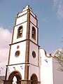 Bell tower of Santo Domingo de Guzmán church


See also
References
- ^ Instituto Canario de Estadística, area
- ^ Instituto Canario de Estadística Archived 2014-04-19 at the Wayback Machine, population
- ^ The Atlantic Navigator. J. Imray and son. 1854-01-01.
- ^ http://koeppen-geiger.vu-wien.ac.at/pdf/kottek_et_al_2006_A4.pdf [bare URL PDF]
- ^ "Valores climatológicos normales. Fuerteventura Aeropuerto".
External links
Places adjacent to Puerto del Rosario | ||||||||||||||||
|---|---|---|---|---|---|---|---|---|---|---|---|---|---|---|---|---|
| ||||||||||||||||
Island capitals of the Canary Islands | ||
|---|---|---|
| Province of Santa Cruz de Tenerife | ||
| Province of Las Palmas | ||
| International | |
|---|---|
| National | |