
Pulicat Lake
| Pulicat Lake | |
|---|---|
Dugarājupatnam Sullurpeta |
Pulicat Lake (பழவேற்காடு) is the second largest
History

In the 1st century, the anonymous mariner who wrote Periplus of the Erythraean Sea listed Podouke (Pulicat)[3] as one of the three ports on the east coast of India. In the 2nd century, Ptolemy's list of ports on this coast included Podouke Emporion.[4]
In the 13th century,
The
A scientific study of the
Geography and topography
The lagoon's boundary limits range between 13.33° to 13.66° N and 80.23° to 80.25°E, with a dried part of the lagoon extending up to 14.0°N.; with about 96% of the lagoon in Andhra Pradesh and 3% in Tamil Nadu. The lagoon is aligned parallel to the coast line with its western and eastern parts covered with sand ridges. Area of the lagoon varies with the tide; 450 square kilometres (170 sq mi) in high tide and 250 square kilometres (97 sq mi) in low tide. Its length is about 60 kilometres (37 mi) with width varying from 0.2 kilometres (0.12 mi) to 17.5 kilometres (10.9 mi). Climate of the lagoon coast line is dominated by
Hydrology
Two rivers which feed the lagoon are the Arani River at the southern tip and the Kalangi River from the northwest, in addition to some smaller streams. The Buckingham Canal, a navigation channel, is part of the lagoon on its western side. The lagoon's water exchange with the Bay of Bengal is through an inlet channel at the north end of Sriharikota and out flow channel of about 200 metres (660 ft) width at its southern end, both of which carry flows only during the rainy season.[9][10][14][15] The lagoon acts as buffer to retain the accumulated flood water till the flood water is discharged gradually to the sea during the monsoon period and cyclones. The lagoon and its river basins are located both in Andhra Pradesh and Tamil Nadu states. The lagoon and its drainage river basins become interstate river basin as per Interstate River Water Disputes Act 1956. Most of the lagoon area including its water outlet to the sea is located in Andhra Pradesh.

The water quality of the lagoon varies widely during various seasons – summer, pre–monsoon, monsoon and post–monsoon – as the depth and width of the lagoon mouth varies causing a dynamic situation of mixing and circulation of waters. The resultant salinity variation and DO (
Flora and fauna
The lagoon has rich flora and fauna diversity, which supports active commercial fisheries and a large and varied bird population.
Limnology
Fishing is the major occupation in the many villages located around the lagoon periphery and on the islands.[10] The lagoon has rich fish diversity, mostly marine species, some truly brackish water and a few freshwater species. Mullets and catfish are the major brackish water fish, which have supported sustenance fishing for the lagoon fishermen. The lagoon is a nursery for several species of fish.[1] Two thirds of the settlements in the lagoon area are in Tamil Nadu and the balance in Andhra Pradesh. 12,370 fishermen live on full-time fishery in the lagoon (6,000 in Andhra Pradesh and 6,370 in Tamil Nadu).[18]
An average 1200 tonnes of fish and crustaceans are harvested annually, of which prawns constitute 60%, followed by mullets.
Avifauna

The shallow lagoon is known for its diversity of aquatic birds and is an important stopover on migration routes and is reported to be the third most important wetland on the eastern coast of India for migratory shorebirds, particularly during the spring and autumn migration seasons. In view of the rich avifauna of the lagoon, two bird sanctuaries are established in the lagoon, one in each of the two states of Andhra Pradesh and Tamil Nadu.
Every year approximately 15,000
Aquatic vegetation
There are 59 species of aquatic vegetation, eight of
Threats and issues
This article may need to be rewritten to comply with Wikipedia's quality standards, as section. (August 2022) |
Due to climate change and delay in the northeast monsoons quite often, lack of dredging activities in the estuaries region like Duggarajapatanam, Mulapadava and Tupilipalem. Diversity of the lake looks like the semi salt desert of what was the Aral Sea. It directly impacts wildlife conversation in those area and livelihoods of the people of the coastal community. Evidence of these changes were inevitable, bird migrations has decreased rapidly due to lack of maintenance of the lake beds. It affects the almost 160 km2 of the lake. Almost 40% of the lake was dried up by 2020. Recent trends and data show that Pullicat Lake is in the verge of destruction due to the lack of dredging activities. If same trends continuous it would be like another Aral Sea.
In the Andhra Pradesh part of the lagoon, several threats to the lagoon have been identified. These are: pollution from sewage, pesticides, agricultural chemicals and industrial effluents from Arani and Kalangi rivers draining into the lagoon bringing fertilizers and pesticides with the runoff from the agricultural field into the drainage basin; domestic sewage; effluents and wastes from numerous fish-processing units; oil spills from the mechanized boats. Release of 4,780 hectares (11,800 acres) of marine chemicals, and salt-manufacturing industry and shrimp farming in more than 1,000 acres (400 ha) on the eastern part of the lagoon, have affected the Pulicat Bird Sanctuary; the livelihood of 30,000 fishermen and 20,000 agricultural labourers (for whom fishing is an off-season economic activity) have also been disturbed. This activity is also reported to have serious impact on aquaculture development.[15]
Runoff from agricultural fields in the drainage basins of the Arani and Kalangi rivers into the lagoon has increased pollution load from fertilizers and pesticides; pollution from domestic sewage is also being released to the lagoon. A petrochemical complex, power plant and a satellite port on Ennore creek have further aggravated the problem;[10] there is threat of flooding of 14 island – villages of the lagoon;[16] subsequent to the tsunami in 2004, the number of fishing boats have increased resulting in the "Catch Per Unit Effort" of fish, prawns and crabs declined from 1000 tonnes to about 700 tonnes;[16] and this has increased the social and fishing rights conflicts between marine based fishermen and the lagoon fishermen.
Due to the
Restoration and social activities
Various groups and non governmental organizations are active in the area. The AARDE Foundation maintains Pulicat Museum at Pazhaverkadu to create awareness among inhabitants and city dwellers. AARDE Foundation represented Pulicat at United Nation's World Urban Forum and Habitat III as an associate-partner. Pulicat Day, part of Ramsar's World Wetlands Day, is celebrated every February by AARDE to bring attention to this fragile environment. An expert plan on "Wildlife Action Plan for Conservation Measures on the Pulicat lagoon Sanctuary" has envisaged to set up a hydro biological research station, visitor center, provide shallow-bottomed boats to enable sanctuary staff to patrol the lagoon and to prepare a management plan and conservation strategy for the entire area. COPDANET is striving to implement traditional "Paadu system" and regular desilting to ensure adequate salt and fresh water mix in the lagoon which could enhance fish resources.[18] Centre for Research on New International Economic Order (CReNIEO) has been promoting welfare of fishermen and management of the natural resources of the lagoon.[24][26] A research study by Loyola College, Chennai reported in 2007 that the lagoon that bore the brunt of industrial pollution has made an ecological turnaround, recording toxicity levels well within permissible limits.[16] Under the Tsunami Emergency Assistance Project (TEAP), construction of a high level bridge across Pulicat lagoon along with approach roads on both sides of the lagoon has been constructed providing a safe escape route for people residing on the islands and also access for emergency response operations.[16][27]
The southern part of the lagoon in Tamil Nadu 5 kilometres (3.1 mi) from the estuary is rich in fishes and the fishing is controlled by a traditional Paadu system.[18] Paadu is a traditional system of getting entitlements to eligible members of a particular community for undertaking specified fishing activity in certain designated areas. The fishing grounds fall within a radius of5 kilometres (3.1 mi) from the mouth of the lagoon with a salinity well maintained without much drying even during low tides. However, this traditional practice is based on caste control of the access rights to the high productive areas and is opposed by eastern fishermen and ocean-side villages. As a result, conflicts leading to violence have been reported.[18]
Transportation
The Tamil Nadu part of the lagoon is 60 kilometres (37 mi) north of Chennai and the nearest airport and major railway station are in Chennai. The nearest suburban railway station is at Ponneri. To reach Pulicat on the National Highway 16 from Chennai, drive north toward Nellore, after 30 kilometres (19 mi), turn right towards Ponneri village and continue 18 km (11.2 mi) to Pulicat village.[19] Sullurpeta station is 17 kilometres (11 mi) from Sriharikota. The Buckingham Canal on the western side of the lagoon is the navigation route through the lagoon used by cargo and passenger vessels.[10]
Gallery
-
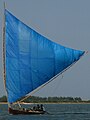 Traditional fishing boat
 -
 Asian openbill stork
 -
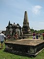 Old Dutch Cemetery
 -

-
 Pulicat Lake
 -
 Greater flamingo (sub adult)
 -
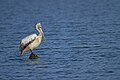 Spot-billed pelican (Pelecanus philippensis) at Pulicat Lake
 -
 House crow
 -
 Tourist in Pulicat Lake
 -
 Fishermen in Pulicat Lake
 -
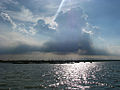
 Ocean-like backwater in Pulicat
 -
 Fisherman cleaning his net in Pulicat Lake


See also
- Nadari river
References
- ^ a b c d e f g h Sanjeeva Raj, P. J. "Macrofauna of Pulicat lagoon" (PDF). National Biodiversity Authority, Chennai. Archived from the original (PDF) on 27 July 2011.
- ^ Azariah, Jayapaul (2007). "4. My Biography Paliacatte to Pulicat 1400 to 2007" (PDF). History of Dutch Fort in Maps, The Fort and Its Settlements - Pallaicatta. Chennai, Tamil Nadu, India: CRENIEO. p. 68. Archived from the original (PDF) on 4 March 2009. Retrieved 21 November 2008.
- ^ Nambiar, O. K. "An Illustrated Maritime History of Indian Ocean Highlighting the Maritime History of the Eastern Sea Board". Archived from the original on 19 June 2009.
- ISBN 0-8248-2332-X.
- ^ a b c "Pulicat".
- ^ a b "Alternative Development Paradigm". Archived from the original on 20 November 2008.
- ^ Azariah, Jayapaul (2007). "3. My Biography Paliacatte to Pulicat 1400 to 2007" (PDF). Pulicat Place Names Through History. Chennai, Tamil Nadu, India: CRENIEO. Archived from the original (PDF) on 4 March 2009. Retrieved 21 November 2008.
- ^ Azariah, Jayapaul (2007). "5. My Biography Paliacatte to Pulicat 1400 to 2007" (PDF). Dutch Trade Relations. Chennai, Tamil Nadu, India: CRENIEO. Archived from the original (PDF) on 4 March 2009. Retrieved 21 November 2008.
- ^ a b c "Holocene sea-level and climatic fluctuations: Pulicat lagoon – A case study" (PDF).
- ^ a b c d e f g h i j "Inventory of Wetlands" (PDF). Archived from the original (PDF) on 3 March 2016. Retrieved 20 November 2008.
- ^ "Pulicat Lake".
- ^ "Chandrayaan-1 Successfully Enters Lunar Orbit". ISRO. Archived from the original on 18 November 2008. Retrieved 8 November 2008.
- ^ a b "Pulicat-Lake Pulicat Lake Lagoon".
- ^ ""My Biography Palliacatta - The Pulicat 1400 to 2007" by Jayapaul Azariah".
- ^ a b c "Pulicat lake: Ecologically Important Areas of Andhra Pradesh Coast". Archived from the original on 11 September 2007.
- ^ a b c d e "At Pulicat lagoon, an ecological turnaround". The Hindu. Chennai, India. 17 April 2007. Archived from the original on 19 April 2007.
- ISSN 2192-1709.
- ^ a b c d "Pulicat Lagoon Fishery Resources and Paadu System".
- ^ a b "... and a placid Pulicat experience". The Hindu. Archived from the original on 26 August 2010. Retrieved 20 November 2008.
{{cite web}}: CS1 maint: unfit URL (link) - ^ a b "Pulicat Lake: Ecologically Important Areas of Tamil Nadu Coast". Archived from the original on 10 April 2009.
- ^ Ramesh, D.A., Ramachandran, S. (2005) Factors influencing flamingo (Phoenicopterus roseus) distribution in the Pulicat Lagoon ecosystem, India. Wetlands Ecology and Management 13 (1):69-72
- ^ "Bird Forum, Pulicat Lake (Andhra Pradesh) (2008)".
- ^ "Pulicat Lake Bird Sanctuary". Tamil Nadu Forest Department. Archived from the original on 4 January 2017. Retrieved 9 September 2007.
- ^ a b "Post Tsunami Restoration of Mangroves, Education and Reestablishment of Livelihoods (EU Asia Pro-Eco II B Post Tsunami Project)".
- ^ "Physics of the tsunami" (PDF). p. 33). Archived from the original (PDF) on 31 October 2005.
- ^ "Pulicat - Projects". CRENIEO. 2004. Archived from the original on 3 July 2008.
- ^ "India:Tsunami Emergency Assistance (Sector) Project" (PDF). Archived from the original (PDF) on 28 October 2007. Retrieved 20 November 2008.